Discover 35 hidden attractions, cool sights, and unusual things to do in Snowdonia National Park (United Kingdom). Don't miss out on these must-see attractions: Snowdon, Llyn Idwal, and Glaslyn. Also, be sure to include Tryfan in your itinerary.
Below, you can find the list of the most amazing places you should visit in Snowdonia National Park (Wales).
Table of Contents
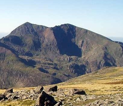
Snowdon
Mountain with panoramic views. Snowdon is the highest mountain in Wales, at an elevation of 1,085 metres above sea level, and the highest point in the British Isles outside the Scottish Highlands. It is located in Snowdonia National Park in Gwynedd. It is the busiest mountain in the United Kingdom and the third most visited attraction in Wales; in 2019 it was visited by 590,984 walkers, with an additional 140,000 people taking the train. It is designated as a national nature reserve for its rare flora and fauna.
The rocks that form Snowdon were produced by volcanoes in the Ordovician period, and the massif has been extensively sculpted by glaciation, forming the pyramidal peak of Snowdon and the arêtes of Crib Goch and Y Lliwedd. The cliff faces on Snowdon, including Clogwyn Du'r Arddu, are significant for rock climbing, and the mountain was used by Edmund Hillary in training for the 1953 ascent of Mount Everest.
The summit can be reached by a number of paths (there are six main paths) and by the Snowdon Mountain Railway, a rack railway opened in 1896 which carries passengers the 4+3⁄4 miles (7.6 kilometres) from Llanberis to the Summit station. The summit building, called Hafod Eryri, houses a cafe and is open only when the railway is operating; it opened in 2009 to replace one built in the 1930s. The railway generally operates from March to the end of October, with trains running to the summit station from May. The daily running schedule depends on weather and customer demand.
Snowdon is one of three mountains climbed as part of the National Three Peaks Challenge. In addition to being the highest mountain in Wales, Snowdon is also the high point (county top) of the historic county of Caernarfonshire.[1]
Address: Rhyd Ddu Path, LL55 4TT Caernarfon
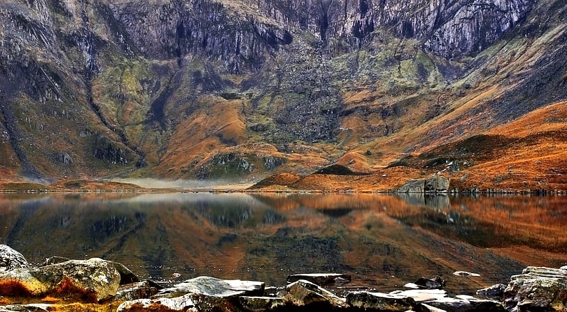
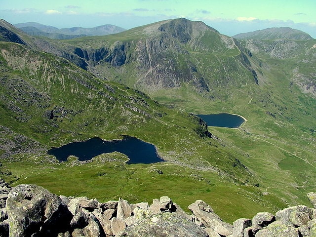
Llyn Idwal
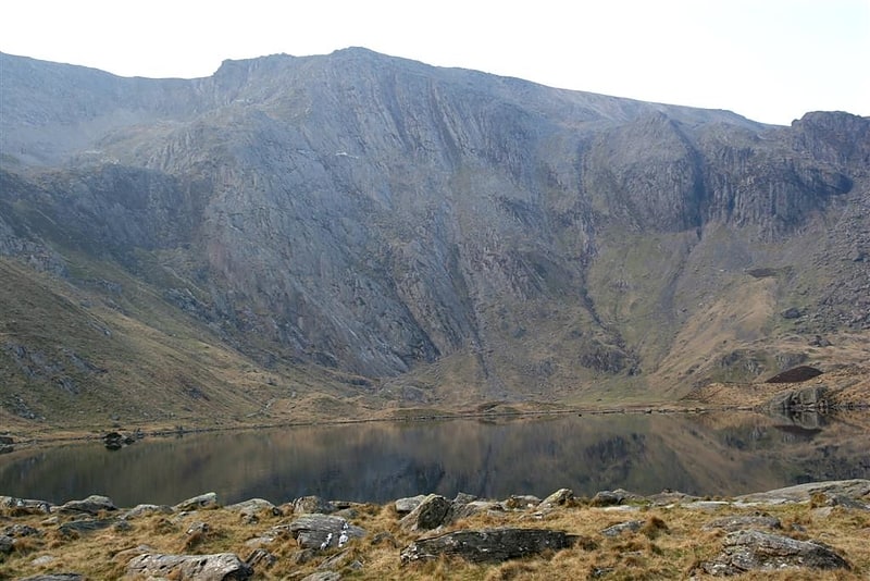
Lake in Wales. Llyn Idwal is a small lake that lies within Cwm Idwal in the Glyderau mountains of Snowdonia.
It is named after Prince Idwal Foel, a grandson of Rhodri Mawr, one of the ancient Kings of Wales. Legend states that the king's unfortunate offspring was murdered by being drowned in the lake. In fact Idwal Foel died in battle against the Saxons in 942 and an alternate version claims that he was cremated beside the lake, as was the burial custom for Celtic nobility.
A number of small streams flow into Llyn Idwal from around Cwm Idwal. One small river flows out and joins the Afon Ogwen river at Pont Pen-y-Benglog near Ogwen Cottage, immediately above the Rhaeadr Ogwen waterfall.[2]
Glaslyn
Lake in Wales. Glaslyn is a lake in the Snowdonia National Park in Gwynedd, north-west Wales.
It is found at approximately 600 metres (2,000 ft) above sea level in a cwm on the eastern flanks of Snowdon. It is a rough ellipse in shape, about 500 metres (1,600 ft) east–west and about 300 metres (1,000 ft) north–south, and the Miners' Track runs along the northern shore.
It has a maximum depth of 39 m (127 feet), and contains about 59 million cubic feet (1.7 million cubic metres) of water.
Glaslyn is the source of the Afon Glaslyn, the major river of Gwynedd, which runs east to the reservoir of Llyn Llydaw before turning south-west to reach the sea at Porthmadog.
In 2020, small particles of microplastic pollution – deposited by rain – were found in the lake, triggering a further investigation of the extent of environmental damage in UK lakes and mountains.[3]
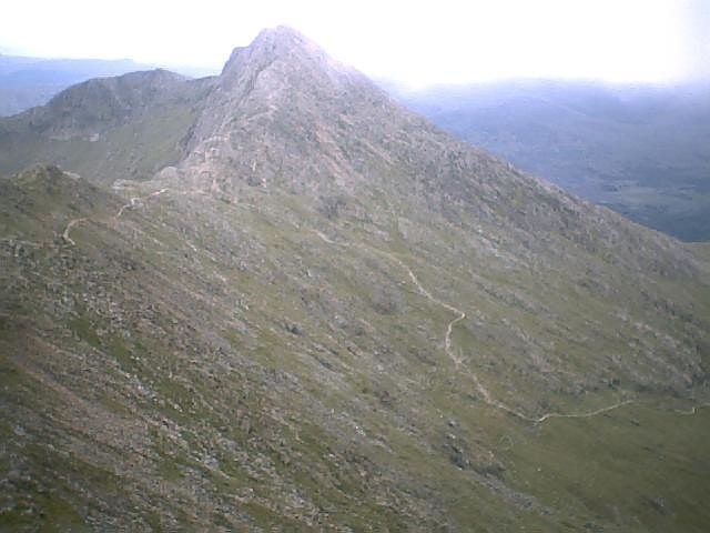
Tryfan
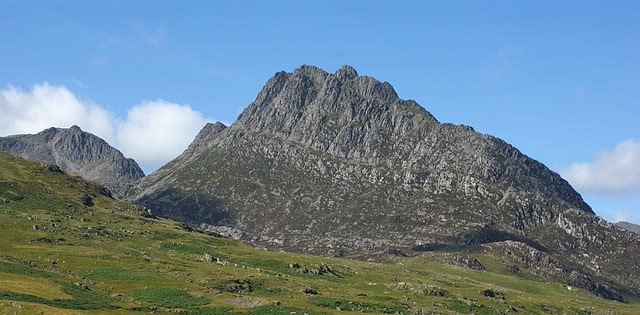
Mountain in Wales. Tryfan Welsh pronunciation:) is a mountain in the Ogwen Valley, Snowdonia, Wales. It forms part of the Glyderau group, and is one of the most recognisable peaks in Britain, having a classic pointed shape with rugged crags. At 917.5 metres above sea level, it is the fifteenth-highest mountain in Wales. Tryfan was voted Britain's favourite mountain by Trail magazine.
Between the mid-1980s and June 2010, its accepted height was 915 metres (3,002 ft). However, it was resurveyed using accurate GPS measurements and found to be 2.4 metres (eight feet) higher (which the pre-1980s surveys also recorded).
Tryfan is said to be the final resting-place of Sir Bedivere (Bedwyr) of Arthurian legend.[4]
National Slate Museum
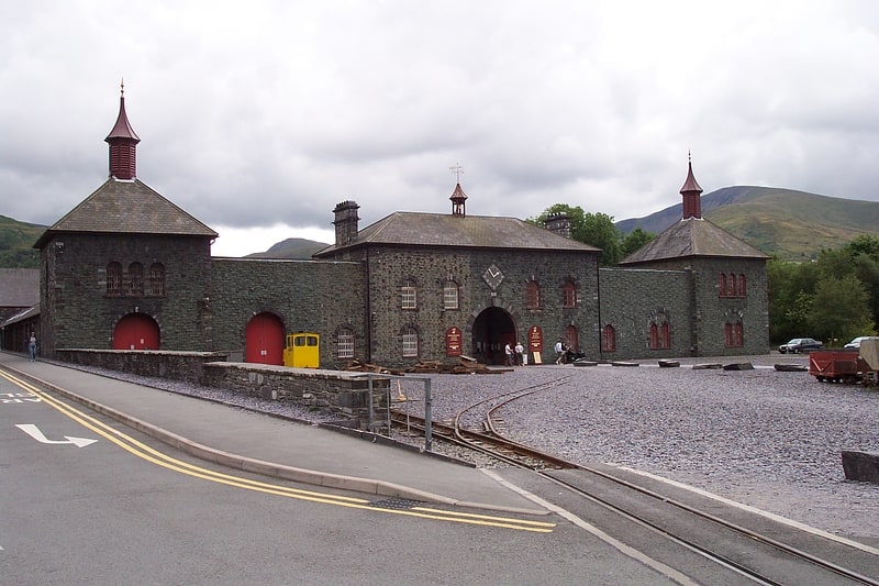
Museum in Wales. The National Slate Museum is located at Gilfach Ddu, the 19th-century workshops of the now disused Dinorwic quarry, within the Padarn Country Park, Llanberis, Gwynedd. The museum is dedicated to the preservation and display of relicts of the Slate industry in Wales.
The museum is an anchor point of the European Route of Industrial Heritage (ERIH) and part of Amgueddfa Cymru – National Museum Wales.[5]
Address: Gilfach Ddu Country Park, LL55 4TY Llanberis
Dolgoch Falls
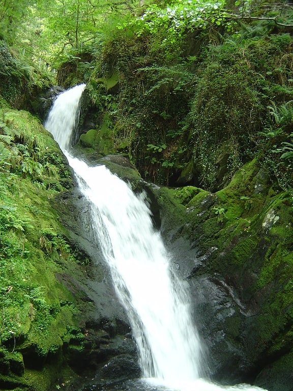
Waterfall. The Dolgoch Falls are a series of three waterfalls near Tywyn in Gwynedd, Mid Wales. The falls are part of the Nant Dol-gôch stream, which flows into the Afon Fathew, and form a popular walk from the nearby Dolgoch station on the Talyllyn Railway.[6]
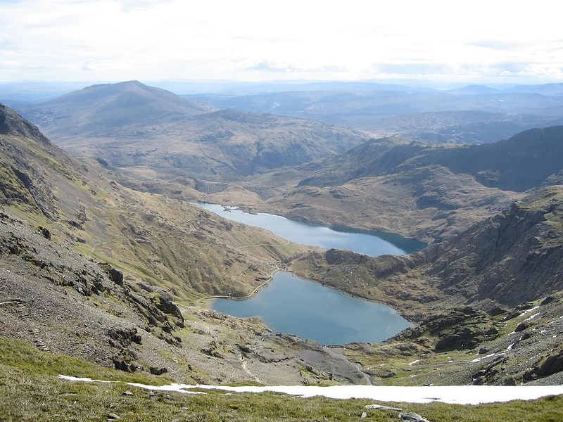
Llynnau Mymbyr
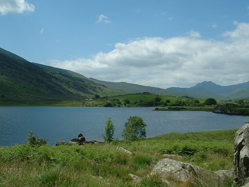
Lake in Wales. Llynnau Mymbyr are two lakes located in Dyffryn Mymbyr, a valley running from the village of Capel Curig to the Pen-y-Gwryd hotel in Snowdonia, north-west Wales. The A4086 runs along their northern banks.
Strictly speaking this is one lake, originally called Llyn Mymbyr, with a maximum depth of 30 feet. About 3/4 mile long in total, a delta has built up midway along the north shore, and this has to all purposes cut the lake in two - hence the plural name.
The river feeding the lakes is the Nantygwryd (or Nant-y-gwryd), which has its source at Llyn Cwm-y-ffynnon, also marked on maps as the Nant Gwryd, which is a tributary of the Afon Llugwy. The two rivers join at Capel Curig.
The lake was used for fly-fishing and sub-aqua courses in the 1960s and is still used today as a canoe training resource by Plas y Brenin and other local education authorities.[7]
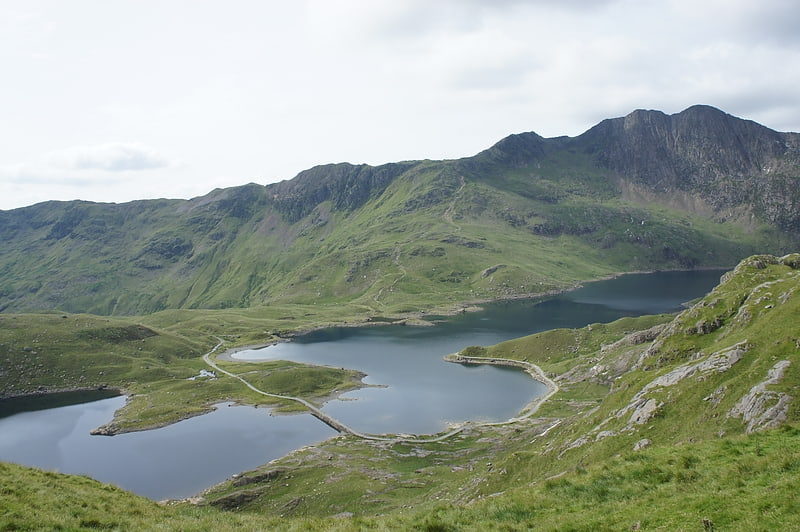
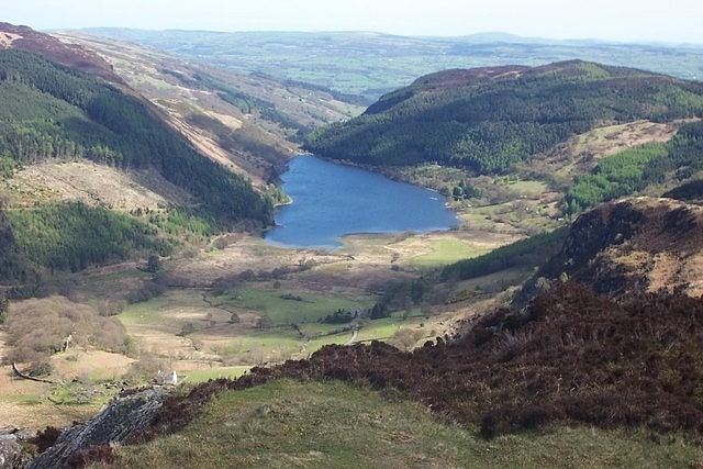
Llyn Llydaw
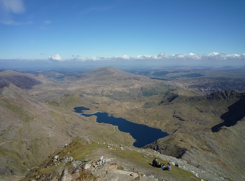
Lake in Wales. Llyn Llydaw is a natural lake in Snowdonia National Park on the flanks of Snowdon, Wales' highest mountain. This long thin lake has formed in a cwm about one-third of the way up the mountain. It is one of the most visited lakes in the United Kingdom. Thousands of people every year visit Snowdon and many walk past this lake on the Miners' Track.[8]
Cwm Idwal
Cwm Idwal is a cirque in the Glyderau range of mountains in northern Snowdonia, the national park in the mountainous region of North Wales. Its main interest is to hill walkers and rock climbers, but it is also of interest to geologists and naturalists, given its combination of altitude, aspect and terrain. In a 2005 poll conducted by Radio Times, Cwm Idwal was ranked the 7th greatest natural wonder in Britain.[9]
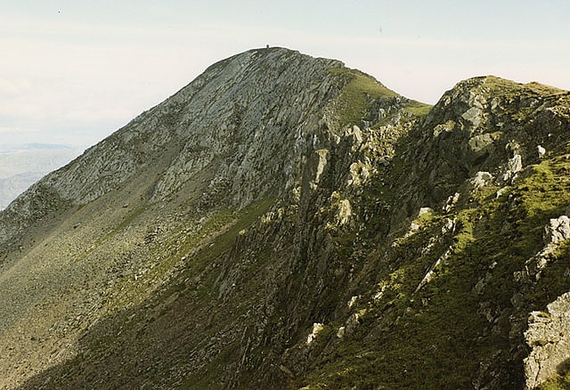
Crib Goch
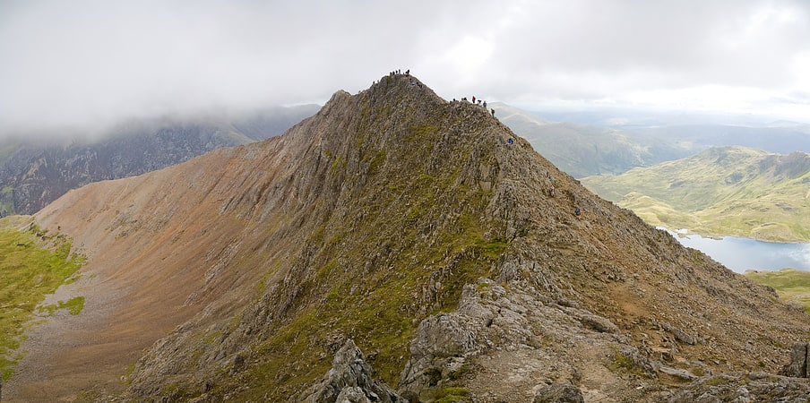
Arête in Wales. Crib Goch is described as a "knife-edged" arête in the Snowdonia National Park in Gwynedd, Wales. The name means "red ridge" in the Welsh language.
The highest point on the arête is 923 metres (3,028 ft) above sea level. All routes which tackle Crib Goch are considered mountaineering routes in winter or scrambles in summer—meaning that they must cross "graded territory" as defined in Steve Ashton's Scrambles in Snowdonia. The easiest of these lines (the ‘bad step’ part of the route) is given a scrambling grade of Grade 1 (the most difficult being Grade 3—routes more difficult than Grade 3 are considered rock climbs).[10]
Aberglaslyn Pass
Gorge in Wales. The Aberglaslyn Pass is a narrow gorge of considerable beauty in Snowdonia, Gwynedd, north Wales. The A498 road/A4085 road follows a relatively level route along the Afon Glaslyn through the pass from Beddgelert to Prenteg and then continues at the edge of the Traeth Mawr via Tremadog to Porthmadog.[11]
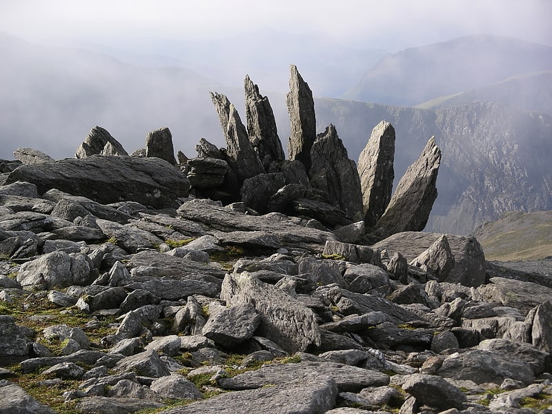
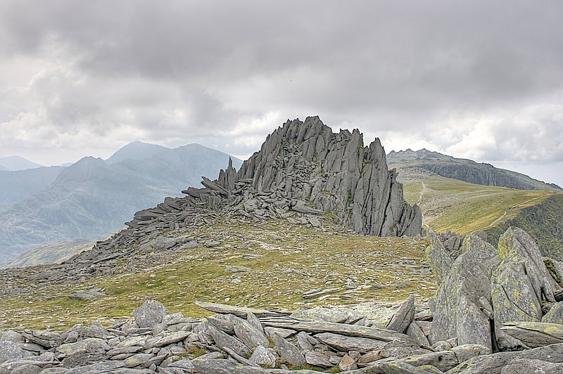
Glyder Fach
Mountain in Wales. Glyder Fach is a mountain in Snowdonia, north-west Wales, and is the second highest of the Glyderau and the sixth highest in Wales. Routes to the summit lead from Tryfan and Bristly Ridge to the north, via Glyder Fawr from Pen-y-Pass to the south, and along the Glyder ridge to the east, towards Capel Curig. It is a popular spot for climbers.
According to Sir Ifor Williams, the word "Glyder" derives from the Welsh word "Gludair", meaning a heap of stones.
Situated near the summit is Y Gwyliwr, a large rock which from the correct angle appears to be precariously balanced, making it a popular place for photographs. (The name means 'The Sentinel', but is usually anglicised as The Cantilever.) Another notable feature, west of the summit, is Castell y Gwynt, a spiky rocky outcrop.[12]
Llyn Crafnant
Lake in Wales. Llyn Crafnant is a lake that lies in a valley in Wales where the northern edge of the Gwydir Forest meets the lower slopes of the Carneddau mountains and, more specifically, the ridge of Cefn Cyfarwydd. The head of the valley offers a profile of crags which are silhouetted at sunset. The Forest Park guide states that "the is one of the most breathtaking views in all Snowdonia". The summits include Crimpiau 475 metres, and Craig Wen 548 metres which provide views to Moel Siabod and the Ogwen Valley, and Snowdon. Further up is Creigiau Gleision. At 63 acres it is the best part of a mile long, although it was clearly once much longer - its southern end shows the evidence of centuries of silting. Jehu's survey recorded a maximum depth of 71 ft.
Crafnant takes its name from “craf”, an old Welsh word for garlic, and “nant”, a stream or valley.
The lake can be reached by car only from Trefriw in the Conwy valley, though many visitors walk there from the village or from the neighbouring lake of Llyn Geirionydd, which runs parallel to it, but a mile distant, the two being separated by Mynydd Deulyn – “mountain of the two lakes”. The lake can also be reached on foot from Capel Curig.
There is a Natural Resources Wales car park with toilets, which is reached just before the lake itself, and the lakeside cafe (open from Easter until late summer) offers car parking for patrons. The lake is a popular fishing spot, and is kept stocked with brown trout and rainbow trout. From the cafe, it is possible to hire boats for fishing or for pleasure. Private boating and swimming are not permitted.
The lake is a reservoir and was dammed at its northern end in 1874, but the dam itself is barely visible as the outflow plunges down steeply from it. By the outflow is an obelisk, erected in 1896 by the inhabitants of Llanrwst which commemorates "the gift to that town of this lake with 19 acres (77,000 m2) of land" by Richard James. The lake is leased to the owners of what is now the cafe.
In the upper part of the valley there is no mains water connection and during the particularly dry summer of 2006 many properties were without water.
The River Crafnant ("Afon Crafnant" in Welsh) joins the River Conwy at Trefriw, but not before some of it has been diverted to pass through the Trefriw Woollen Mills to generate hydro-electricity for the machinery.
Cornel, a large property in 25 acres (10 ha) on the southern banks of the lake, is owned and operated by the Welsh Scout Council.
Areas around the lake have been used for location shots in Hollyoaks, Tomb Raider II, the 1981 fantasy movie Dragonslayer, and the lake also appeared briefly in the 1966 film Morgan: A Suitable Case for Treatment.[13]
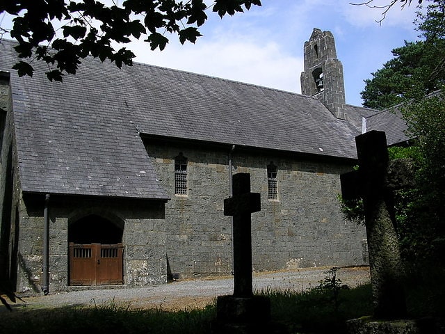
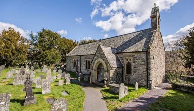
St Tanwg's Church
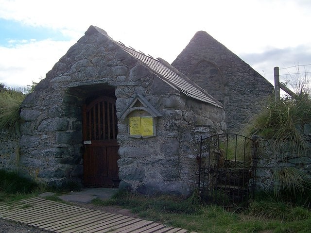
Church in Wales. St Tanwg's Church, Llandanwg, also known as "the church in the sand", is an early medieval church dedicated to St Tanwg in the village of Llandanwg, Gwynedd, Wales. The church is a Grade I listed building.[14]
Arenig Fawr
Mountain in Wales. Arenig Fawr is a mountain in Snowdonia, North Wales, close to Llyn Celyn reservoir, alongside the A4212 between Trawsfynydd and Bala.[15]
Moelwyn Mawr
Mountain in Wales. Moelwyn Mawr is a mountain in Snowdonia, North Wales and forms part of the Moelwynion. Its summit overlooks the Vale of Ffestiniog and has views in all directions.[16]
Glyder Fawr
Mountain in Wales. Glyder Fawr is a mountain in Snowdonia, Wales, the highest peak in the Glyderau range at just over 1,000 metres, having had its height recalculated in 2010 using GPS. It is the fifth-highest mountain in Wales and has several walking and scrambling routes leading to its summit. According to Sir Ifor Williams, the word "Glyder" derives from the Welsh word "Gludair", meaning a heap of stones.[17]
St Mark's Church
Church in Wales. St Mark's Church, Brithdir, is a redundant church in the hamlet of Brithdir, Gwynedd, Wales. It is designated by Cadw as a Grade I listed building, and is under the care of the Friends of Friendless Churches. It is considered to be one of the finest Arts and Crafts churches in Wales.[18]
Llyn Nantlle Uchaf
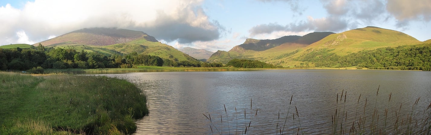
Lake in Wales. Llyn Nantlle Uchaf is a lake in the Nantlle Valley, Gwynedd, Wales. The lake forms the foreground in Richard Wilson's painting "Snowdon from Llyn Nantlle".
Llyn Nantlle Isaf (Lower Nantlle Lake) no longer exists as it was drained to protect the slate works.[19]
Rhobell Fawr
Mountain in Wales. Rhobell Fawr is the site of an ancient volcano that was active during the Early Ordovician period in the Arenig range within the Snowdonia National Park.
Despite its modest height of 734 m (2,408 feet), it is a mountain with views of higher peaks all around, including the north face of Cadair Idris and distant Snowdon.
The paths are not well trodden, but there is a distinct path up from Bwlch Goriwared, a couple of miles north-north-east of the small village of Llanfachreth.[20]
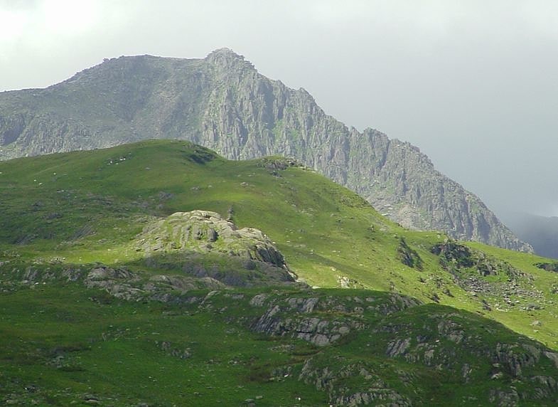
Y Lliwedd
Mountain in Wales. Y Lliwedd is a mountain, connected to Snowdon in the Snowdonia National Park, North Wales.
Its summit lies 898 metres (2,946 ft) above sea level.
The eastern flanks are steep cliffs rising above Glaslyn and Llyn Llydaw. Y Lliwedd is the most conspicuous of the peaks for those who approach Snowdon via the Miners' and Pyg tracks. Few that summit Snowdon continue over to Y Lliwedd as the challenge of Wales' highest peak is enough, leaving Y Lliwedd quiet and peaceful even when queues are forming at the summit of Snowdon.
Hikers and mountaineers often pass over Y Lliwedd when walking the Snowdon Horseshoe. The noted British climber George Mallory undertook many of his early climbs here. It was also the site of considerable training activity for the 1953 British Everest Expedition.
The north face of Y Lliwedd was explored in the late 19th century and in 1909 was the subject of the first British climbing guide, The climbs on Lliwedd by J. M. A. Thomson and A. W. Andrews.
Two subsidiary peaks of Y Lliwedd are listed as Nuttalls: Lliwedd Bach 818 metres (2,684 ft): SH628532 and Y Lliwedd East Peak 893 metres (2,930 ft): SH623532.[21]
Y Garn
Mountain in Wales. Y Garn is a mountain in Snowdonia, North Wales, part of the Glyderau.
It is one of the Welsh 3000s — the 15 summits in Wales over 3,000 feet (914.4 metres) in height. It is the tenth-highest peak in Wales. Moderate snow accumulations can take place on the western-sloping side of the mountain from October to May.
The south-westerly side of the mountain slopes gently down to the Nant Peris valley. The other, north-easterly side is of a different character, consisting of two steep-sided cwms, Cwm Clyd and Cwm Cywion, and finally Llyn Idwal and Ogwen Cottage. Along the ridge to the north lies Elidir Fawr, while to the south-east is the top of the Twll Du and Glyder Fawr.[22]
Mary Jones World
Mary Jones World is a small heritage centre located in Llanycil near Bala, Gwynedd, Wales. Situated on the north shore of Bala Lake, it provides information on Mary Jones, a fifteen-year-old girl from Llanfihangel-y-Pennant. After she had saved her money for six years, in 1800 Jones walked 26 miles to buy a copy of a Welsh-language Bible, which she thought would be available in Bala, only to find that they were sold out. The Reverend Thomas Charles was reputed to have given her his own spare copy.
The heritage centre is an initiative of the British and Foreign Bible Society and was opened on 5 October 2014 at a cost of £1.3 million in the former village church which was dedicated to Saint Beuno. It is open daily from April to October from 10am to 5pm with free visitor parking and a café. As well as information about Mary the centre tells about the growth of the Bible Society, and Thomas Charles who sold Mary her bible is buried in the church yard of St Beuno. School group visits are encouraged and there is a children's play area next to the centre.[23]
Castell Caer Seion
Castell Caer Seion is an Iron Age hillfort situated at the top of Conwy Mountain, in Conwy County, North Wales. It is unusual for the fact that the main fort contains a smaller, more heavily defended fort, complete with its own distinct defences and entrance, with no obvious means of access between the two. The construction date of the original fort is still unknown, but recent excavations have revealed evidence of occupation as early as the 6th century BC, whilst the smaller fort can be dated with reasonable certainty to around the 4th century BC. Whilst the forts were constructed in different periods, archaeologists have uncovered evidence of concurrent occupation, seemingly up until around the 2nd century BC. The larger fort contained around 50 roundhouses during its lifetime, whereas examinations of the smaller fort have turned up no more than six. The site was traditionally associated with Maelgwyn Gwynedd, but there is no evidence pointing to a 6th-century occupation. The fort and wider area beyond its boundaries have been said to retain significant archaeological potential, and are protected by law as a scheduled ancient monument.[24]
Pont Aberglaslyn
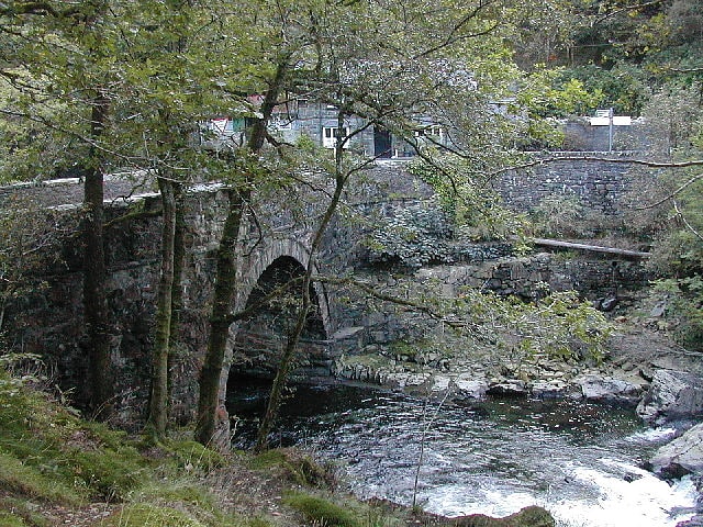
Bridge in Wales. Pont Aberglaslyn is a stone arch bridge over the Afon Glaslyn and the surrounding hamlet, located near Beddgelert and Nantmor in Gwynedd, north-west Wales. A well-known beauty spot, according to Peter Bishop it was "one of the most visited sites in north Wales" at the end of the eighteenth century; an 1883 guidebook wrote that it "has occupied the artist's pencil perhaps more than any other".[25]
Garnedd Ugain
Mountain in Wales. Garnedd Ugain, often referred to as "Crib-y-Ddysgl", is a pyramidal mountain in Wales that forms part of the Snowdon Massif. It is the second-highest peak in Wales, and lies just under one kilometre north of the summit of Snowdon itself.
It is part of the Snowdon Horseshoe route, being linked to Crib Goch via the col at Bwlch Coch, and to Snowdon summit via the col at Bwlch Glas. It is also linked to Cwm Glas to the northeast via a steep arete called Clogwyn y Person, which joins the main Crib y Ddysgl ridge about 500 metres (1,600 feet) east of the summit.[26]
Tŷ Mawr Wybrnant
Tourist attraction in Penmachno, Wales. Tŷ Mawr Wybrnant is a house located in the Wybrnant Valley, in the community of Bro Machno, near Betws-y-Coed in Conwy County Borough, North Wales. It was the birthplace of Bishop William Morgan, first translator of the whole Bible into Welsh.
Tŷ Mawr Wybrnant is owned by the National Trust and has been restored to its probable 16th-century appearance. Despite its name (Tŷ Mawr, "Big House") it is very small by today's standards, but it houses some old furniture and a collection of Welsh Bibles, including William Morgan's Bible of 1588. There are also other Bibles in many other languages, donated by visitors to the house from around the world.
The house is most easily reached from the village of Penmachno, 4 miles from Betws-y-coed, but can also be reached from the A470 between Betws-y-coed and Dolwyddelan.
Ty Mawr Wybrnant closed to visitors in early 2020 due to the COVID-19 pandemic. The collection of Bibles was temporarily moved to a dedicated exhibition at Chirk Castle.
The Afon Wybrnant is the stream near which the house is located, and its name is usually appended to the house's name to distinguish it from other Tŷ Mawrs. The origins of the name Wybrnant are not wholly known. Although nant denotes a small stream and wybr is an old word for sky or cloud, some would have it that the word is derived from a corruption of gwiber, meaning "adder" or "viper". According to legend, long ago a gwiber was a huge flying snake, and one lived in this valley.[27]
Mynydd Mawr
Mountain in Wales. Mynydd Mawr is a mountain in Snowdonia, North Wales, approximately 7 km west of Snowdon itself, overlooking Llyn Cwellyn and being the northern outlier of the Moel Hebog group. A popular ascent starts from Rhyd Ddu. On its western flank are the remains of ancient settlements and field systems. The profile of Mynydd Mawr from the north is often thought to resemble an elephant lying down, and consequently the mountain is often colloquially also called "Yr Eliffant", or "Elephant Mountain" by non-Welsh speakers.
The summit offers extensive views, on a clear day to the west, the views extend to the Lleyn Peninsula and Caernarfon Bay, from the north-west includes Anglesey. To the north lies Moel Eilio and to the east is Moel Hebog and Snowdon. On exceptionally clear days, the Wicklow Mountains in Ireland can be seen westwards across the Irish Sea from the summit.[28]
Plas Brondanw
Tea house in Garreg, Wales. Plas Brondanw in Garreg, Llanfrothen, Gwynedd, North Wales, was the family home of Clough Williams-Ellis, creator of the Italianate village Portmeirion, and elements of similar architectural styles can be seen at both locations. It is a grade II* listed building. The gardens, in a series of garden rooms enclosed by yew hedges and open lawns, linked by carefully planned vistas, is one of only three Grade I listed gardens in Gwynedd.
Plas Brondanw stands on the road to the tiny village of Croesor and the distinctive Snowdonia mountain named Cnicht, within the Snowdonia National Park.[29]
Aran Fawddwy
Mountain in Wales. Aran Fawddwy is a mountain in southern Snowdonia, Wales, United Kingdom. It is the highest point of the historic county of Merionethshire. It is the only peak in Wales outside North Snowdonia above 900m, and higher than anywhere in Great Britain outside Northern Snowdonia, the Scottish Highlands and the Lake District. The nearest urban centres to the mountain are Dinas Mawddwy to the south, Llanymawddwy to the southeast, Llanuwchllyn on the shores of Bala Lake to the north, and Rhydymain to the west. The nearest settlements with around 2,000 people are Bala and Dolgellau. On the eastern slopes of Aran Fawddwy is the small lake named Creiglyn Dyfi, the source of the River Dyfi. Its sister peak is Aran Benllyn at 885 metres. There is also a middle peak- Erw y Ddafad-ddu.
A cairn is placed on the eastern ridge as a memorial to RAF Mountain Rescue team member Michael Robert Aspain who was struck and killed by lightning in 1960.[30]
Mynydd y Dref
Mountain in Wales. Mynydd y Dref or Conwy Mountain is a hilly area to the west of the town of Conwy, in North Wales. To the north it overlooks the sea of Conwy Bay, and to the south lie the foothills of the Carneddau range of mountains, of which it forms a part. Mynydd y Dref is the remains of an ancient volcano that erupted about 450 million years ago.
At the summit of Conwy Mountain are the Neolithic Hut Circles and the Iron Age hillfort of Castell Caer Seion (sometimes called Castell Caer Lleion). Castell Caer Seion comprised a stone walled fort, and remains show this to have been an extensive site, incorporated more than 50 hut circles and levelled platform houses, and with a citadel and outposts.
Limited excavations were undertaken in 1951. No datable remains were found, only slingstones, querns and stone pestles and mortars, which suggests that, unlike many hillforts in north Wales, this site was not reoccupied in the late Roman period.
Millstones were quarried on Conwy Mountain during the Napoleonic wars.
Tracks and footpaths cross Conwy Mountain, and many walks, which can be accessed from Sychnant Pass at its western end. The route along Conwy Mountain comprises a section of the North Wales Path, a way-marked long-distance walk of some 60 miles which runs close to the North Wales coast between Prestatyn in the east and Bangor in the west.[31]
Carnedd Llewelyn
Mountain in Wales. Carnedd Llewelyn, usually spelt Carnedd Llywelyn in Welsh, is a mountain massif in the Carneddau range in Snowdonia, north-west Wales. It is the highest point of the Carneddau and the second highest peak by relative height in Wales, 49th in the British Isles and lies on the border between Gwynedd and Conwy.[32]
Pitt's Head
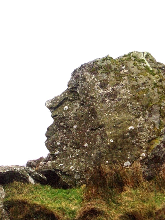
Pitt's Head is a distinctive rock located at grid reference SH576515, close to the A4085 road in Gwynedd, Wales. Its distinction lies in a resemblance to the profile of politician William Pitt the Younger.[33]
Castell y Gwynt
Summit in Wales. Castell y Gwynt is a top of Glyder Fach in Snowdonia, north-west Wales. It has the merit of being the only 3000 ft Welsh summit classed as only a Nuttall, hence it is not included in the Welsh 3000s. It has a prominence of 15.7 m, and was only included on the Nuttall's list after re-surveying in 2007. The top is more famous as a feature than a summit.
"Castell y Gwynt" and the "Cantilever Stone" featured in Walt Disney's Dragonslayer.[34]
Moel Hebog
Mountain in Wales. Moel Hebog is a mountain in Snowdonia, north Wales which dominates the view west from the village of Beddgelert. It gives name to a whole range of peaks in the north-western corner of Snowdonia, which include the Nantlle Ridge and Mynydd Mawr.
From that side, Moel Hebog has a rocky face with a distinctive pointed summit, although from other sides, it appears more rounded. The exposed rock means that it is often visited by students of geology. Much of the mountain consists of welded, fiamme rich rhyolitic tuff.
It is often climbed from Beddgelert and it can be combined with the nearby mountains of Moel yr Ogof and Moel Lefn for a longer walk. This route, however, does involve some easy scrambling.
On Moel yr Ogof can be found Owain Glyndŵr's Cave. The view of Moel Hebog and Llyn Gwynant from the north near Snowdon is one of the most photographed in Snowdonia.
A late Bronze Age shield was found in a bog near Moel Hebog in 1784. It is now in the British Museum's collection.[35]