Discover 35 hidden attractions, cool sights, and unusual things to do in Peak District (United Kingdom). Don't miss out on these must-see attractions: Odin Mine, Dovestone Reservoir, and St Peter's Church. Also, be sure to include Stanage Edge in your itinerary.
Below, you can find the list of the most amazing places you should visit in Peak District (England).
Table of Contents
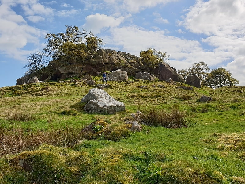
Odin Mine
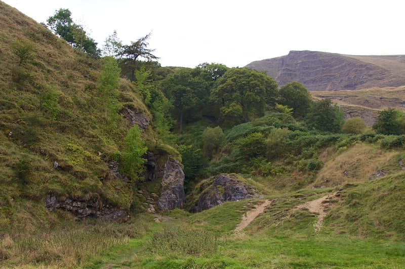
Tourist attraction in England. Odin Mine is a disused lead mine in the Peak District National Park, situated at grid reference SK133835. It lies on a site of 25 hectares near the village of Castleton, England. It is the oldest documented mine in Derbyshire and is thought to be one of the oldest lead mines in England. The mine is a Scheduled Ancient Monument and has biological and geological significance within the Castleton Site of Special Scientific Interest.[1]
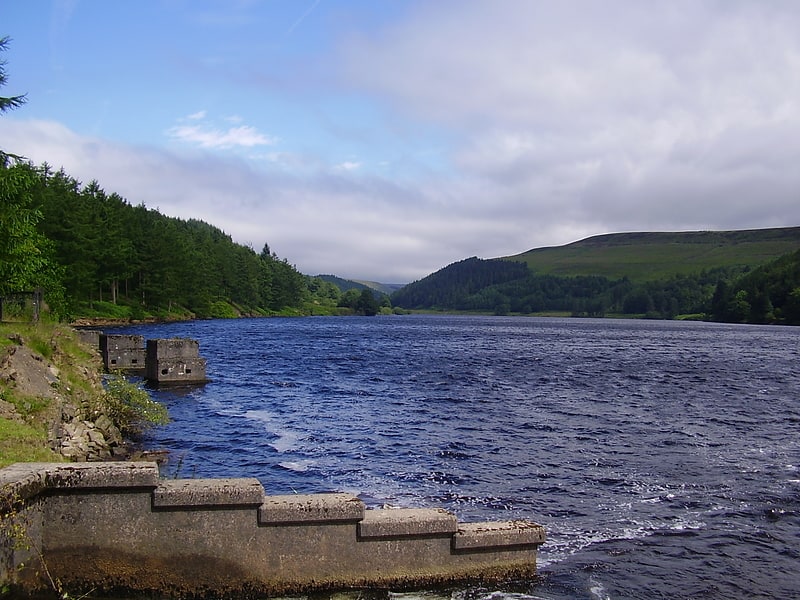
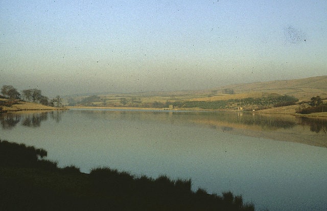
Dovestone Reservoir
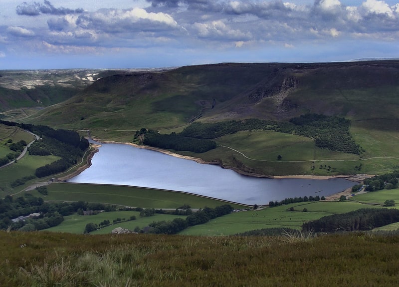
Reservoir in England. Dovestone Reservoir lies at the convergence of the valleys of the Greenfield and Chew Brooks above the village of Greenfield, on Saddleworth Moor in Greater Manchester, England. The reservoir is on the western edge of the Peak District National Park. It supplies drinking water to the surrounding area and is a tourist attraction, providing several walks amongst picturesque landscapes.[2]
St Peter's Church
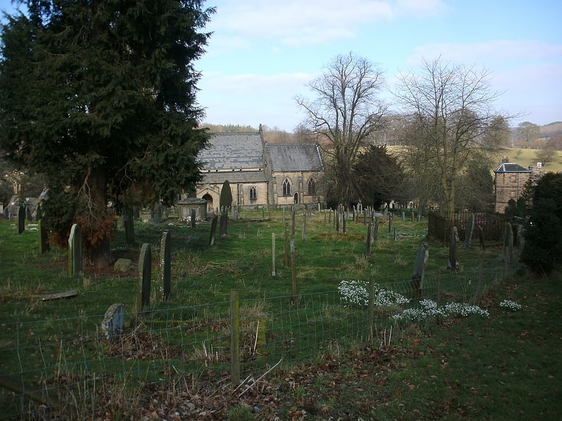
Church in Edensor, England. St Peter's Church, Edensor, is a Grade I listed church in Edensor, Derbyshire. St Peter's is the closest parish church in the Church of England to Chatsworth House, home of the Dukes of Devonshire, most of whom are buried in the churchyard. St Peter's is in a joint parish with St Anne's Church, Beeley.
The historic listing summary for the church states that it was built in the 12th century, modified in the 15th and "rebuilt in 1867 by Sir George Gilbert Scott".[3]
Address: 1 Jap Ln, DE45 1PH Bakewell
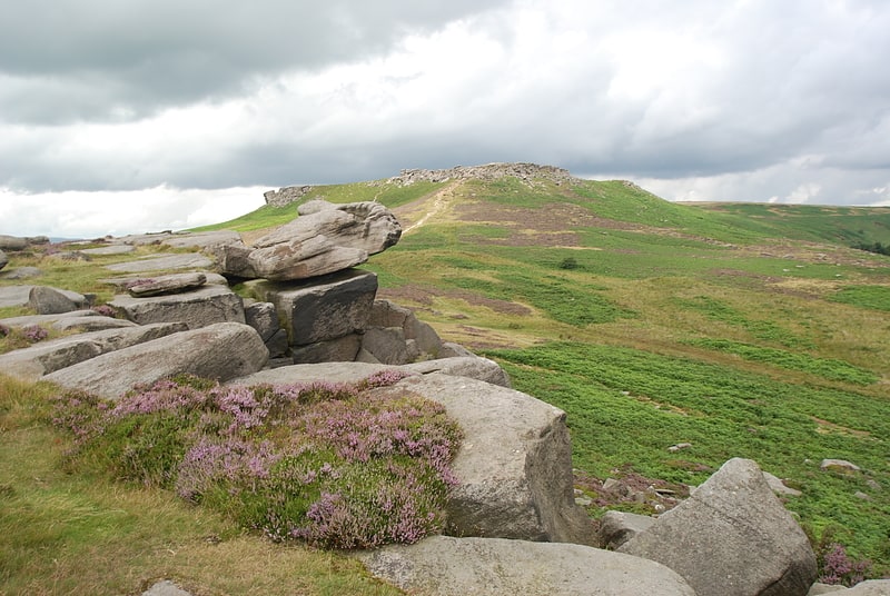
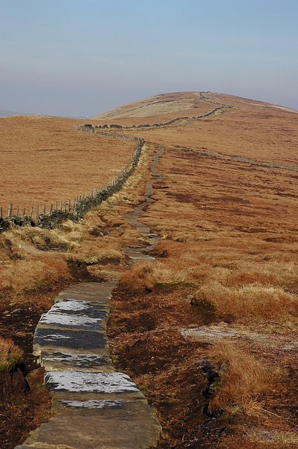
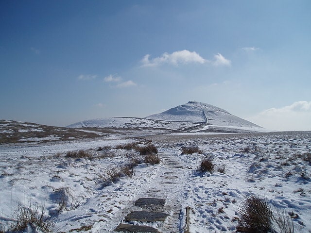
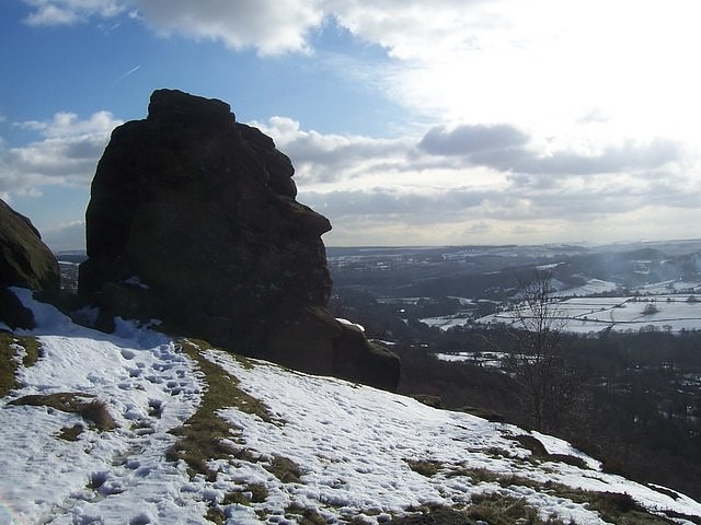
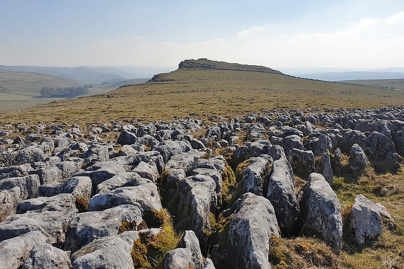
Stanage Edge
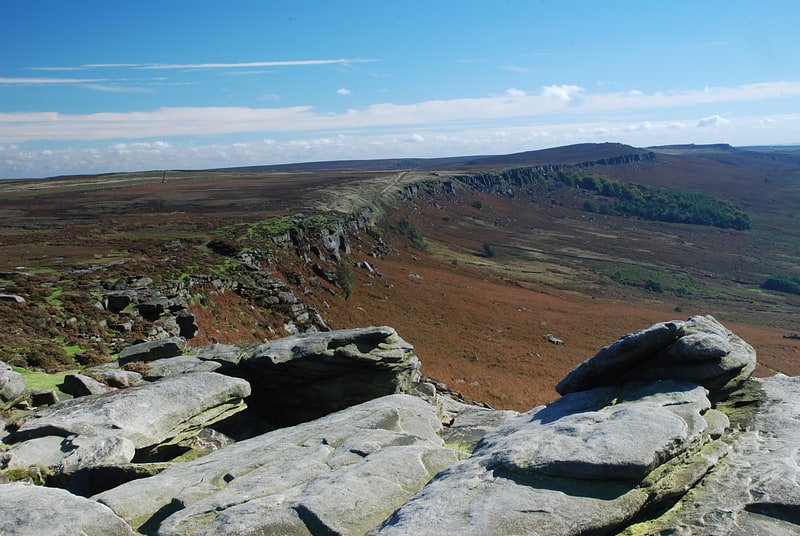
Landmark destination for rock climbers. Stanage Edge, or simply Stanage is a gritstone escarpment in the Peak District, England, famous as a location for climbing. It lies a couple of miles to the north of Hathersage, and the northern part of the edge forms the border between the High Peak of Derbyshire and Sheffield in South Yorkshire. Its highest point is High Neb at 458 metres above sea level. Areas of Stanage were quarried in the past to produce grindstones, and some can still be seen on the hillside—carved, but never removed.[4]
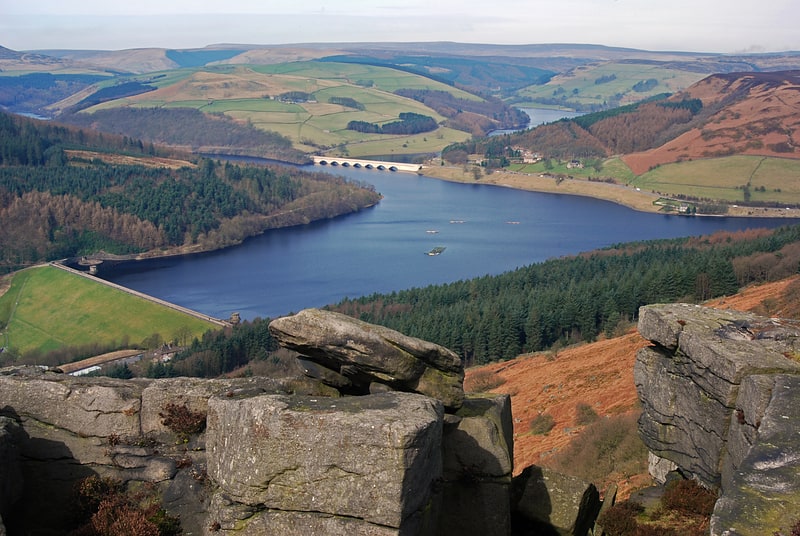
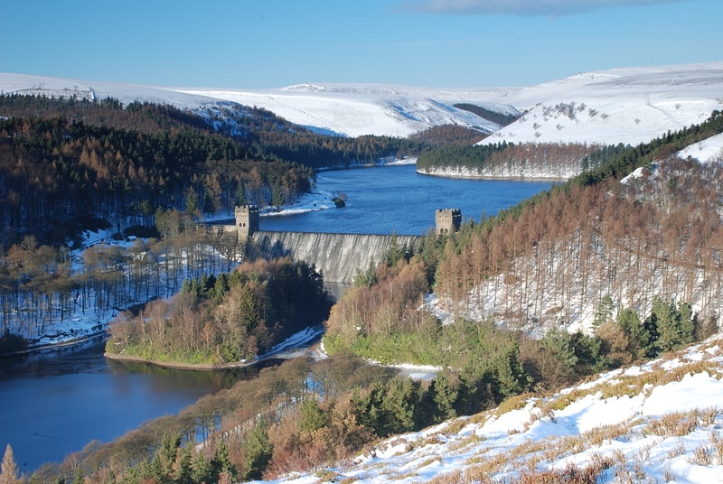
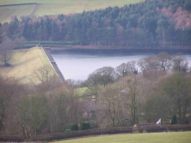
Derwent Reservoir
Reservoir in England. Derwent Reservoir is the middle of three reservoirs in the Upper Derwent Valley in the north of Derbyshire, England. It lies approximately 10 miles from Glossop and 10 miles from Sheffield. The River Derwent flows first through Howden Reservoir, then Derwent Reservoir and finally through Ladybower Reservoir. Between them they provide practically all of Derbyshire's water, as well as to a large part of South Yorkshire and as far afield as Nottingham and Leicester.
Derwent Reservoir is around 1.5 miles (2.4 km) in length, running broadly north–south, with Howden Dam at the northern end and Derwent Dam at the south. A small island lies near the Howden Dam. The Abbey Brook flows into the reservoir from the east.
At its full capacity the reservoir covers an area of 70.8 hectares (175 acres) and at its deepest point is 34.7 metres (114 ft) deep.[5]
Lud's Church
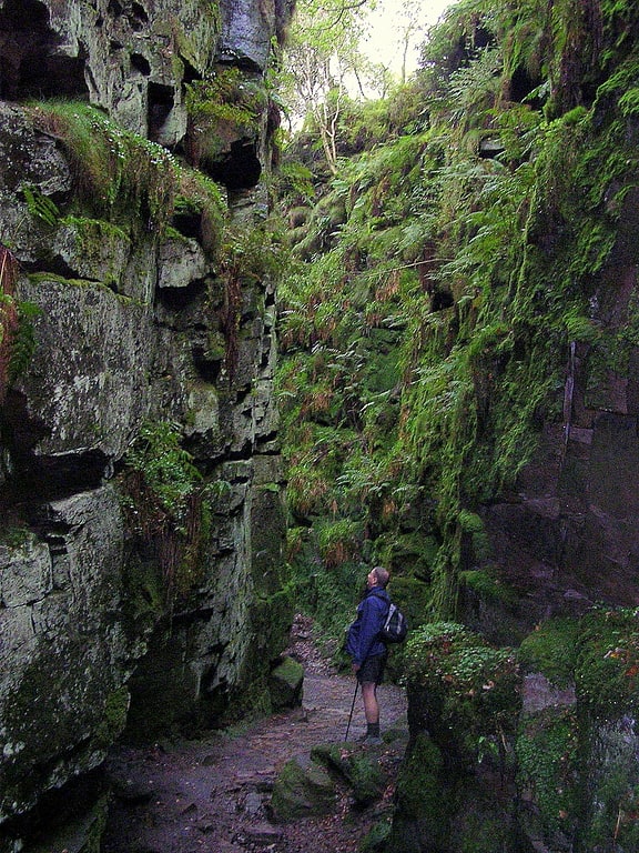
Tourist attraction in England. Lud's Church is a deep chasm penetrating the Millstone Grit bedrock created by a massive landslip on the hillside above Gradbach, Staffordshire, England. It is located in a wood known as Back Forest, in the Dark Peak, towards the southwest fringe of the Peak District National Park about 4 kilometres west of the A53 between Leek and Buxton. Over 100 metres long and 18 metres deep, all but the upper third of the slope has slipped forward towards the River Dane. It is mossy and overgrown, wet and cool even on the hottest of days.[6]
Ladybower Reservoir
Waterway for scenic walks and hikes. Ladybower Reservoir is a large Y-shaped, artificial reservoir, the lowest of three in the Upper Derwent Valley in Derbyshire, England. The River Ashop flows into the reservoir from the west; the River Derwent flows south, initially through Howden Reservoir, then Derwent Reservoir, and finally through Ladybower Reservoir. The reservoir is owned by Severn Trent plc.
The area is now a tourist attraction, with the Fairholmes visitors' centre located at the northern tip of Ladybower. The east arm of the reservoir, fed by the Ladybower Brook, is overlooked by Hordron Edge stone circle.[7]
Kinder Scout
Geographical feature. Kinder Scout is a moorland plateau and national nature reserve in the Dark Peak of the Derbyshire Peak District in England. Part of the moor, at 636 metres above sea level, is the highest point in the Peak District, the highest point in Derbyshire, and the highest point in the East Midlands. This summit is sometimes simply called the Peak. In excellent weather conditions the city of Manchester and the Greater Manchester conurbation can be seen, as well as Winter Hill near Bolton, and the mountains of Snowdonia in North Wales.
To the north across the Snake Pass lie the high moors of Bleaklow and Black Hill, which are of similar elevation.
Kinder Scout featured on the BBC television programme Seven Natural Wonders (2005) as one of the wonders of the Midlands, though it is considered by many to be in Northern England, lying between the cities of Manchester and Sheffield. In chronostratigraphy, the British sub-stage of the Carboniferous period, the "Kinderscoutian", derives its name from Kinder Scout.[8]
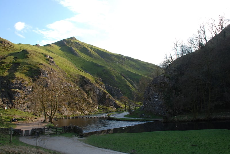
Dovedale

Valley in England. Dovedale is a valley in the Peak District of England. The land is owned by the National Trust, and annually attracts a million visitors. The valley was cut by the River Dove and runs for just over 3 miles between Milldale in the north and a wooded ravine near Thorpe Cloud and Bunster Hill in the south. In the wooded ravine, a set of stepping stones cross the river, and there are two caves known as the Dove Holes.
Dovedale's other attractions include rock pillars such as Ilam Rock, Viator's Bridge, and the limestone features Lovers' Leap and Reynard's Cave.[9]
Howden Reservoir
Reservoir in England. The Howden Reservoir is a Y-shaped reservoir, the uppermost of the three in the Upper Derwent Valley, England. The western half of the reservoir lies in Derbyshire and the eastern half is in Sheffield, South Yorkshire; the county border runs through the middle of the reservoir, following the original path of the River Derwent. The longest arm is around 1.25 miles in length. The reservoir is bounded at the southern end by Howden Dam; below this, the Derwent flows immediately into Derwent Reservoir and subsequently the Ladybower Reservoir. Other tributaries include the River Westend, Howden Clough and Linch Clough.
Work commenced on the dam's construction on 16 July 1901 and completed in July 1912. The chief engineer was Edward Sandeman. He was also in charge of building nearby Derwent dam and was awarded the Telford Medal in 1918 for his work ‘Derwent Valley Waterworks’. The works involved constructing a temporary village at Birchinlee, or "Tin Town", for the workers, a temporary railway line from the main line at Bamford, construction of a link aqueduct to the Derwent Dam. The dam is of solid masonry construction, and 117 ft tall (36 m), 1,080 ft long (330 m), and impounds 1,900,000 imperial gallons (8,600 kl) of water, from a catchment area of 5,155 acres (20.86 km2). The workers who died during the construction of the dam were buried in Bamford Church.
To the east of the reservoir stands Featherbed Moss, one of the highest tops in the area at 545 metres (1,788 ft), and one of several tops of that name in the area. This is not to be confused with the more well-known Featherbed Moss on the Pennine Way between Kinder Scout and Bleaklow.[10]
Thorpe Cloud
Peak in England. Thorpe Cloud is an isolated limestone hill lying between the villages of Thorpe and Ilam on the Derbyshire/Staffordshire border at the southern end of Dovedale. It is a popular hill amongst the many day-trippers who visit the area, and provides a fine viewpoint north up the dale and south across the Midland plain.
Like much of the dale, including Bunster Hill on the opposite bank, it is in the ownership of the National Trust, and is part of their South Peak Estate. These Dovedale properties were acquired by the Trust in 1934.
In 1997, the writer Jeff Kent discovered that a double sunset could be seen against Thorpe Cloud from the top of nearby Lin Dale and, two years later, the phenomenon was first captured on film by the photographer Chris Doherty. The occurrence is visible in good weather on and around the summer solstice and perhaps beyond, when the sun sets on the summit of the hill, partially reappears from its steep northern slope and sets for a second and final time shortly afterwards. The precise event and its location are described in Kent's book The Mysterious Double Sunset.
Thorpe Cloud and Dovedale were used as locations in the 2010 film of Robin Hood, starring Russell Crowe. Thorpe Cloud can be clearly made out in several scenes towards the end of the film.
Thorpe Cloud also has a rifle range which local and national shooting clubs use.[11]
Damflask Reservoir
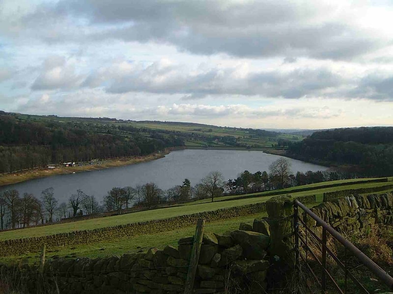
Reservoir in England. Damflask Reservoir is situated at grid reference SK277907 five miles west of the centre of Sheffield in the Loxley valley close to the village of Low Bradfield and within the city's boundaries. The hamlet of Stacey Bank is located to the east. The reservoir has a capacity of 4,250.9 million litres and has a surface area of 47 hectares with a maximum depth of 27 metres. The dam wall is approximately 400 metres wide with a height of 28 metres.[12]
Chee Dale
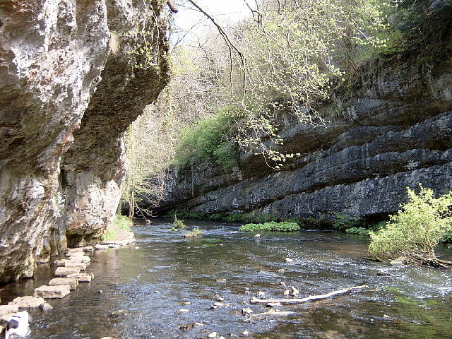
Chee Dale is a steep-sided gorge on the River Wye near Buxton, Derbyshire, in the Peak District of England.
Wye Dale continues upstream towards Buxton while downstream are Miller's Dale village and valley.
Chee Dale has a protected nature reserve (close to the village of Wormhill), which is overseen by the Derbyshire Wildlife Trust. The reserve contains ash, yew and rock whitebeam woodland on the cliff sides and abundant wild flowers including cowslips, early purple orchids, rock rose and the rare Jacob's ladder. Dippers are often seen darting low above the river and bobbing on rocks in the river. Other birds nesting in the valley include blackcap, chiffchaff and willow warbler. Chee Dale is part of the Wye Valley Site of Special Scientific Interest (SSSI), running for 15 kilometres (9.3 mi) east of Buxton.
The Monsal Trail bridleway runs for 8.5 miles (13.7 km) from Topley Pike Junction (at the head of Chee Dale) to Rowsley near Bakewell, along the disused Manchester, Buxton, Matlock and Midlands Junction Railway line. It passes through Upper Chee Dale and then enters Chee Tor Tunnels 1 and 2 through to Miller's Dale.
There is also a riverside footpath along the length of Chee Dale with several wooden footbridges over the river. Sets of stepping stones allow walkers to pass the foot of the cliffs.
The crags of carboniferous limestone in Upper Chee Dale and of Chee Tor cliff in Lower Chee Dale have extensive rock climbing routes.
At the head of Chee Dale it joins Great Rocks Dale to the north, at the former railway stations of Blackwell Mill and Chee Dale Halt. Great Rocks Dale is a dry valley and is the site of Tunstead Quarry, one of the largest limestone quarries in the UK.
The Pennine Bridleway crosses the River Wye over a footbridge at Blackwell Mill.
Access into the deep gorge is limited. Miller's Dale car park is the obvious place for visitors to get into Chee Dale. At the west end of Chee Dale there is Topley Pike layby with limited parking by the A6 road. There is also a short steep footpath into Chee Dale from Wormhill.[13]
Titan Cave
Titan is a natural cavern near Castleton in the Derbyshire Peak District, and is the deepest shaft of any known cave in Britain, at 141.5 metres. The existence of Titan was revealed in November 2006, following its discovery on 1 January 1999 after cavers discovered connections from the James Hall Over Engine Mine to both Speedwell Cavern and Peak Cavern. Previously, the deepest known underground shaft in Britain had been Gaping Gill on the slopes of Ingleborough in the Yorkshire Dales.
A group of Peak District cavers discovered the shaft after finding an account by an 18th-century academic, James Plumtree, in a university library. Initial explorations in the James Hall Over Engine Mine led to the discovery of a large shaft named Leviathan, before further excavations revealed the existence of Titan.[14]
Higger Tor
Peak in England. Higger Tor or Higgar Tor is a gritstone tor in the Dark Peak, in the north of the Peak District National Park in England. It overlooks the Burbage Valley and the Iron Age hill fort of Carl Wark to the southeast.
The tor stands to the south west of Sheffield, just within the city boundary, about 200 metres (220 yd) east of the border with Derbyshire, which runs along the nearby road to Ringinglow. The village of Hathersage is approximately 2 kilometres (1.2 mi) to the west.
A scene from the 1987 film The Princess Bride was filmed nearby at Carl Wark with Higger Tor visible in the background.[15]
Tissington Hall
Wedding venue in Tissington, England. Tissington Hall is an early 17th-century Jacobean mansion house in Tissington, near Ashbourne, Derbyshire. It is a Grade II* listed building.
The FitzHerberts, descended from the Norman family of Norbury Hall, acquired Tissington by the marriage of Nicholas FitzHerbert (the second son of John FitzHerbert of Somersal Herbert) to Ciceley Frauncis, heiress of Tissington, in 1465.
The old moated manor at Tissington was replaced with the new mansion in 1609 by Francis FitzHerbert and remains the home of the FitzHerbert family. The current occupant is Sir Richard FitzHerbert, 9th Baronet. Both Francis FitzHerbert and his son (Sir) John served as High Sheriff of Derbyshire, a post that circulated among the county families.
It is the hall that makes Tissington Hall unusual. It is one of a small group of compact Derbyshire gentry houses in which a central hall runs through the house from front to back. Nicholas Cooper surmises that the unusual, progressive character may be due to the influence of lodges (he counted some fifty emparked estates in Saxton's map of the shire, of 1570) and the grand example of a through-hall at Hardwick. Behind a two-storey enclosed entrance porch (illustration, right), the hall is entered at the centre of one end. On the left are two parlours separated by a stairhall, on the right a kitchen and buttery. Corner towers on the garden front, now linked by the additional upper floor above the gallery range, provide further rooms.
A rococo gothick fireplace in the house follows a published design by Batty Langley.
The Hall is open to the public at specified times of the year and is available for commercial and private functions.
The Hall is Grade II* listed, the second-highest designation. The garden terraces and walls, stable block, staff quarters and outbuildings, and entrance gates are separately listed, all at Grade II.[16]
Win Hill
Hill in England. Win Hill is a hill north west of Bamford in the Derbyshire Peak District of England. Its summit is 462 m above sea level and it is bounded by the River Derwent to the east, the River Noe to the south west and Ladybower Reservoir to the north, with a ridge running north west linking it to Kinder Scout. The Roman road from Glossop over the Snake Pass crosses the ridge to the north and descends to Hope and the old Roman base of Brough in the Hope Valley, with the Hope Cross, a marker post dating from 1737, at the highest point of the road.
On top of Win Hill lies Win Hill Pike, locally known as the Pimple. Win Hill Pike has an Ordnance Survey triangulation point, or trig point. Sometimes misnamed the Old Witches Knoll, Win Hill Pike is often used for a Duke of Edinburgh Award station.
Win Hill is commonly ascended from Yorkshire Bridge or Hope. The ascent from Yorkshire Bridge is a steep climb of 300 metres (980 ft) in 1.2 km (3⁄4 mi) by Parkin Clough, first through woods then over the moor to the top. Routes from Hope are gentler, either via Twitchill Farm or the villages of Aston and Thornhill. Depending on direction of travel, Win Hill is either the first or last hill on the Derwent Watershed and Edale Horseshoe challenge walks.
With around 144 m (472 ft) of relative height, Win Hill is only a few metres short of qualifying as a Marilyn.
The hill's counterpart, Lose Hill, lies to the west on the opposite side of the River Noe. In relatively recent times, the two hills' names have prompted a fanciful tale concerning the outcome of an imagined 7th-century battle between the forces of Edwin of Northumbria and Cynegils of Wessex. Edwin's forces occupied Win Hill, while Cynegils' men camped on Lose Hill. As the battle progressed, Cynegils' forces advanced up Win Hill, and Edwin's retreated behind a temporary wall they had built near the summit. They pushed the boulders of the wall downhill, crushing the Wessex soldiers and gaining victory in the battle. However, there is no historical basis for the tale, and no evidence of any battle ever being fought here. A more prosaic explanation for the name is that Win Hill was originally recorded as Wythinehull, meaning "Withy Hill" or "Willow Hill". Fragments of willow can still be found in the otherwise largely coniferous plantation on the approach from Yorkshire Bridge.[17]
Address: Win Hill, Peak District
The Roaches
Ridge in England. The Roaches is a prominent rocky ridge above Leek and Tittesworth Reservoir in the Staffordshire Peak District of England. The ridge with its rock formations rises steeply to 505 m.
Along with Ramshaw Rocks and Hen Cloud they form a gritstone escarpment, which is popular with hikers, rock climbers and freerunners. It is often very busy especially at weekends.
The Roaches Estate which includes Hen Cloud was purchased by the Peak District National Park Authority in the 1980s to safeguard the area from adverse development. From May 2013 Staffordshire Wildlife Trust took on the management of the Roaches Estate.
In clear conditions, it is possible to see much of Cheshire and views stretching as far as Snowdon in Wales and Winter Hill in Lancashire.
The Roaches are the most prominent part of a curving ridge which extends for several miles from Hen Cloud in the south to Back Forest and Hangingstone in the northwest. At the top there is a small pool called Doxey Pool that is, according to legend, inhabited by a water spirit. Nearby are the broad hills of Gun and Morridge.[18]
Padley Gorge
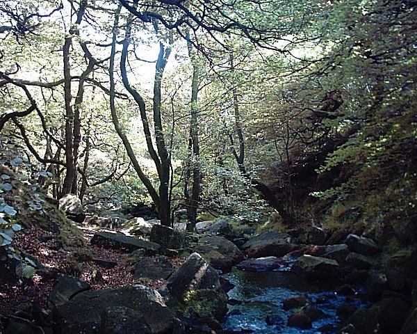
National reserve in England. Padley Gorge is a deep but narrow valley in the Peak District, Derbyshire between the village of Grindleford and the A6187 road.
The gorge is wooded with a stream, the Burbage Brook. This stream used to form the boundary between Derbyshire and Yorkshire but the boundary now follows the Hathersage Road, the A6187, formerly the A625.
Padley gorge is one of the furthest inland examples of Temperate Rainforest in the UK.
Padley Gorge begins near Grindleford Station at a stile where a post has been installed. Although the valley continues up towards Hathersage Road and Burbage, the gorge finishes at the edge of the woodland. Padley Gorge forms the backbone of several walks in the area and the railway station approach road forms a convenient car park for walkers.
A short distance from the upper section of the gorge is the Fox House, a pub and hotel on the road to Sheffield. Longshaw Estate is equally close and its lands include the gorge. The lands to the north and east of the gorge are moorland with relics of stone circles, for example the Stoke Flatt stone circle on Froggatt Edge and Bronze Age field system at Swine Sty.
The valley is part of the Yarncliff Wood, Padley Site of Special Scientific Interest (SSSI), designated in 1972 as "the best example of the remnant oak-birch woodland that once covered much of the edges of the gritstone uplands of the Peak District". The citation mentions three species of Umbilicaria lichen said to be very rare in the Midlands, and describes the site as a breeding site for pied flycatcher, wood warbler and hawfinch.
Padley Gorge is a popular tourist spot, and as of May 2020 has a five-star rating on TripAdvisor.[19]
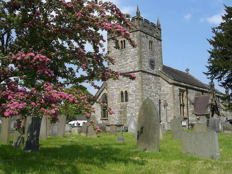
All Saints' Church
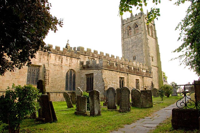
Church in Youlgreave, England. All Saints’ Church, Youlgreave is a Grade I listed parish church in the Church of England in Youlgreave, Derbyshire.[20]
Address: 26 Church St, DE45 1WL Bakewell
Arbor Low
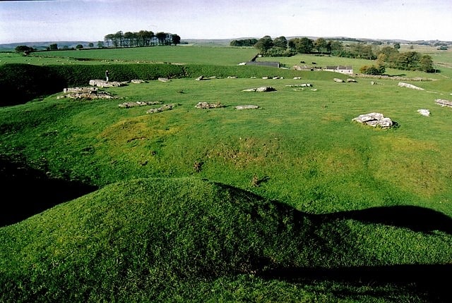
Historical landmark in England. Arbor Low is a well-preserved Neolithic henge in the Derbyshire Peak District, England. It lies on a Carboniferous Limestone plateau known as the White Peak area. The monument consists of a stone circle surrounded by earthworks and a ditch.[21]
Harthill Moor
Harthill Moor is a small upland area in the Derbyshire Peak District of central and northern England, lying between Matlock and Bakewell near the villages of Birchover and Elton. The moor is within the southern portion of Harthill civil parish. Its highest point is 272 metres above sea level. The River Bradford flows along the northern edge of the moor past Youlgreave and into the River Lathkill at Alport. Harthill Moor is a rich prehistoric landscape with several protected Scheduled Ancient Monuments.
The rock of Harthill Moor and nearby Stanton Moor is known as Ashover Grit, an outlier of Millstone Grit. This is a coarse-grained sandstone which weathers to produce coarse sub-soils, rich in sand, and the soils themselves are typically podzols. The Ashover Grit sandstone layer lies on top of shale, which in turn lie upon Carboniferous limestone.
Robin Hood's Stride (also called Mock Beggar Hall) is a prominent natural rock formation with distinctive pinnacle towers. Prehistoric rock art has been found on and close to the gritstone outcrop. It is a popular location for bouldering and limited short climbing is possible on Weasel pinnacle and Inaccessible pinnacle. Nearby Cratcliffe Tor provides more challenging rock climbing, with over 200 graded routes.
Cratcliff Rocks is an extensive rock outcrop on the edge of Harthill Moor in the eastern gritstone moors of Derbyshire. Cratcliff Rocks defended settlement is an ancient enclosure in the field to the north east of Robin Hood's Stride. The monument lies on the western edge of the Cratcliff Rocks outcrop and is in the form of a round enclosure about 100m wide with a 5m wide ditch cut into the rock. Several building platforms have been identified inside the enclosure. Whilst the site has not been excavated, it is considered to be linked to the other Bronze Age features of Harthill Moor. Cratcliff Rocks hermitage is a medieval hermit's cave. The rock shelter has a number of recesses cut into the walls for candles and sacred objects. A bas-relief crucifix carved in the cave has been dated to the 13th or 14th century. On the rock face outside the shelter, chiselled grooves and sockets for timber beams indicate where the roof structure was of a building adjoining the cave.
Nine Stones Close is a Bronze Age stone circle about 30m across, with four remaining upright stones about 2m high. Several original stones were removed in the 18th and 19th centuries, one of which stands in a field wall 70m to the south where it was taken to be used as a gatepost. Partial excavations of the circle were conducted by Thomas Bateman in 1847, Jewitt and Greenwell in 1877 and J P Heathcote in 1939. Many Bronze Age flints and pot-sherds were discovered. Doll Tor stone circle lies about 1 kilometre (0.62 mi) east of Nine Stones Close. A further 1.5 kilometres (0.93 mi) north east is Nine Ladies stone circle on Stanton Moor.
The Castle Ring defended settlement (immediately north of Harthill Moor Farm) now consists of an oval earthwork ditch (about 5m wide and 100m across) with inner and outer banks, up to 2m high. It hasn't been excavated but it is considered to be an integral part of the Bronze Age landscape of Harthill Moor. Harthill Moor bowl barrow is a Bronze Age burial mound about 150m SE of Harthill Moor Farm. It is 20m long and 11m wide. It was partially excavated in 1877 by Jewitt and Greenwell. A limestone cist was found with the remains from two cremations.
The Derbyshire Portway prehistoric road runs across Harthill Moor in a north-south direction. It passes between Robin Hood's Stride and Cratcliff Rocks and past Nine Stones Close. It was an ancient route between Mam Tor in the Peak District to the Hemlock Stone near Nottingham. The Limestone Way long distance footpath follows the Derbyshire Portway route across Harthill Moor but then heads around the Castle Ring earthwork towards Youlgreave.
Harthill Hall, on the northern edge of the moor near Alport, is the manor of a great 13th-century estate. The 16th-century manor house, farm house and 14th-century chapel still stand. Harthill was recorded as Hortel and Hortil in the Domesday Book, as part of the lands of the Norman knights Henry de Ferrers and Ralph FitzHubert.[22]
Thor's Cave
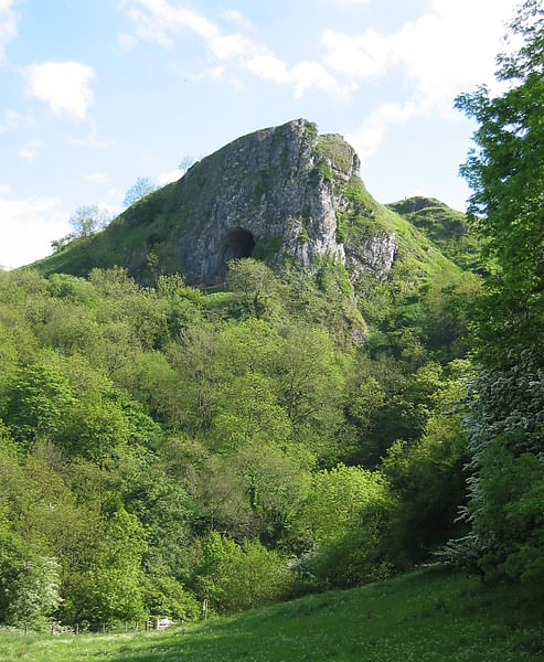
Cave in England. Thor's Cave is a natural cavern located at SK09865496 in the Manifold Valley of the White Peak in Staffordshire, England. It is classified as a karst cave. Located in a steep limestone crag, the cave entrance, a symmetrical arch 7.5 metres wide and 10 metres high, is prominently visible from the valley bottom, around 80 metres below. Reached by an easy stepped path from the Manifold Way, the cave is a popular tourist spot, with views over the Manifold Valley. The second entrance is known as the "West Window", below which is a second cave, Thor's Fissure Cavern.
Thor's Cave was served by a railway station on the Leek and Manifold Valley Light Railway from 1904 to 1934; the disused line now forms the Manifold Way.[23]
Derwent Edge
Escarpment in England. Derwent Edge is a Millstone Grit escarpment that lies above the Upper Derwent Valley in the Peak District National Park in the English county of Derbyshire. An Ordnance Survey column marks the highest point of the Edge at Back Tor. North of Back Tor the edge extends into Howden Edge and enters the county of South Yorkshire.[24]
Wet Withens
Wet Withens is a Bronze Age henge on Eyam Moor in the Derbyshire Peak District, England. The prehistoric circle of 10 upright stones is a protected Scheduled Monument.
It is sometimes known as Wet Withers (Old English for 'the wet land where willows grew').
On gritstone moorland over 300 metres above sea level, the site has clear views of the valley of the River Derwent and Higger Tor. The site is well away from public footpaths but is on "Open Access" land following the Countryside and Rights of Way Act 2000. The earthen bank of Wet Withens is over 30m in diameter, making it the largest embanked stone circle in Derbyshire. Most of the stones of the ring are quite hidden amongst the heather and reeds. 7 stones are still upright but some of those are leaning inwards. The 'Chair Stone' (70cm high) is the tallest and most prominent stone with a ledge cut out of its face, appearing as a seat. There could have been up to 18 stones originally if the stones had been spaced out evenly.
About 10m north of the henge is a large stone cairn (known as Eyam Moor Barrow) about 27m long and 1m high. The cairn has been damaged from quarrying and/or excavation activity over the centuries. Near the middle of the cairn is an unusual cup-marked stone. The cairn's shape indicates that it was likely to have been a prehistoric burial barrow.
Wet Withens is also known as Eyam Moor 1 because there are 2 smaller stone circles about 650m to the east, which are also Scheduled Monuments: Eyam Moor 2 and Eyam Moor 3.
There are a number of other ancient henges in Derbyshire including Arbor Low, The Bull Ring, Doll Tor, Hordron Edge, Nine Stone Close and Twyford Henge.[25]
Cats Tor
Hill. Cats Tor is a Peak District hill on the border between Cheshire and Derbyshire, between the towns of Macclesfield and Buxton. The summit is 518 metres above sea level. Tor is an Old English word for a high, rocky hill.
The higher peak of Shining Tor is about 2 km south along The Tors gritstone ridge. The ridge continues to the north past Windgather Rocks and Taxal Edge towards Whaley Bridge. On the west wide of the ridge, water drains into Todd Brook which feeds Toddbrook Reservoir. East of Cats Tor are views of the Goyt Valley, Foxlow Edge and Fernilee Reservoir.
The moorland ridge on which Cats Tor lies is designated "Open Access" land for the public, following the Countryside and Rights of Way Act 2000. The closest access is from Pym Chair car park, from where a public footpath, laid on large stone slabs, runs south across Cats Tor and continues south along the ridge to Shining Tor. A local legend tells that Pym Chair is the spot where a highway man called Pym robbed passers by on the packhorse route. Another story is that Pym was a preacher who gave sermons there.
The open gritstone moorlands of the Upper Goyt Valley (Wild Moor, Goyt's Moss, Burbage Edge, Shining Tor to Cats Tor ridge and Hop Moor) are a designated Site of Special Scientific Interest (SSSI). Heather is the main plant but the heathland is habitat for a variety of native grasses, rushes, sedges and shrubs including bilberry, crowberry, cowberry and cross-leaved heath. Hare’s-tail cottongrass and sphagnum moss are common along The Tors ridge. The area is important for upland breeding birds including a large population of golden plover, as well as red grouse, curlew, lapwing, whinchat, snipe, twite, ring ouzel and merlin.
On 30 September 1943 two Republic P-47D Thunderbolt planes crashed on Cats Tor. Both pilots were killed. The USAAF aircraft were from the 2906th Observation Group. The planes were on a training flight from RAF Atcham. Both aircraft flew straight into the hillside in cloud in the mid-afternoon.
Cats Tor is a popular location for paragliding, used by the Derbyshire Soaring Club and the Peak Soaring Association.
Oldgate Nick, on the northern slope of Cats Tor, is a gritstone buttress with 15 graded rock climbing routes.[26]
Navio Roman Fort
Navio Roman fort overlooks a tight bend of the River Noe at Brough-on-Noe near Hope, Derbyshire, in England. Navio fort and vicus is a Scheduled Monument.
The town was recorded as Nauione in the Ravenna Cosmography's list of all known places in the world in about 700 AD. The entry is followed by places with which Navio had road connections: Aquis Arnemeza (Buxton), Zerdotalia (Ardotalia, later called Melandra fort, near Glossop) and Mantio (Manchester). There is also an entry for the river Anava, next to the river Dorvantium, which is considered to be the River Derwent.
A Roman milestone was discovered in 1862 in the Silverlands district of Buxton. It is the oldest inscribed milestone found in Derbyshire. The inscription is:
TRIB POT COS II P P A NAVIONE M P XI
which means ‘With the tribune's power, twice consul, father of this country. From Navio 11 miles.' The milestone is on display in the Buxton Museum.
Navio is Latin for "on the river". The Roman name of the fort Navio was later changed to the Old English word for fort, brough. Excavations in th 1930s by Sir Ian Richmond and J.P. Gillam established the locations of the perimeters of successive forts on the same site. Navio fort was originally about 3 acres (1.2 ha) in size and built of timber and earthworks around 80 CE. It was rebuilt in stone in a rectangular form (about 90 by 105 metres (295 by 344 ft)) around 150 CE from when it was occupied for over 200 years. It was subsequently rebuilt and altered and in use until around 350 CE. The site of the fort now consists of earthwork banks and ditches around an earthen platform, buried remains and a few exposed stone slabs. Earlier excavations in 1903 by John Garstang uncovered steps into an underground stone-walled chamber below the Principia or headquarters building. A large Centurial stone and a gritsone altar were found in the fort's strong room. They are on display in the Buxton Museum.
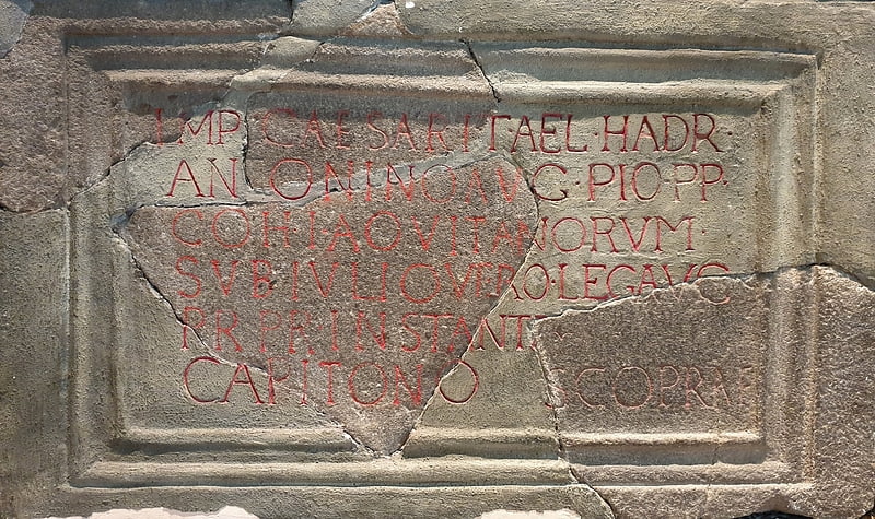
The Centurial stone found at Navio dates from the rebuilding of the fort in 154 CE by occupying soldiers from southwest France. The inscription on it reads:
IMP CAESARI T AEL HADR ANTONINO AVG PIO P P COH I AQVITANORVM SVB IVLIO VERO LEG AVG PR PR INSTANTE CAPITONO SCO PRAE
This translates as: "The 1st Cohort of Aquitanians under Julius Verus, the Emperor’s Governor of Britain, under the instructions of Capitonius Fuscus, Prefect of the Cohort, erected this stone in honour of the Emperor Caesar Titus Aelius Hadrianus Antoninus Augustus Pius, Father of his Country." The gritsone altar is dedicated to the goddess Arnemetia (or Arnomecta), who dwelt in the sacred waters at Buxton, and is inscribed with:
DEAE ARNOMECTE AEL MOTIO V S L L M
This translates as: "To the Goddess Arnomecta, Aelius Motio gladly, willingly and deservedly fulfilled his vow."
The fort guarded the Doctor's Gate route northwest to the larger fort of Melandra (near Glossop), the Portway road to the south and the Batham Gate road (between the fort at Templeborough and the Roman spa town of Aquae Arnemetiae, modern-day Buxton). This was an important route for access to sites of lead production in the Peak District.
In the 1980s geophysical surveys identified the extent of the vicus (settlement adjoining the fort) to the south and east of the fort. Excavations in the 1990s determined that the vicus extended further east beyond Bradwell Brook. In 2019 excavations of the vicus uncovered foundations from stone and timber buildings. The team also found many pottery fragments, carved stone pieces, coins and a ‘ballista ball’ (ammunition for a large missile-throwing device).[27]
Shutlingsloe
Hill in England. Shutlingsloe is a hill near the village of Wildboarclough, in the east of the county of Cheshire. It stands to the south of Macclesfield Forest, on the edge of the Peak District and within the Peak District National Park.
A steep-sided hill with a distinctive profile, sometimes described as the 'Matterhorn of Cheshire', it is the third highest peak in the historic county (Black Hill being the highest and Shining Tor second highest) with an elevation of 506 m (1,660 ft) and commands excellent views over Cheshire. The Peak District Boundary Walk crosses the summit, which is the highest point on the footpath's 200-mile long route.
The name derives from old English 'Scyttel's hlaw' meaning 'Scyttel's (personal name) hill' and is one of several 'low' names in the Peak District, from the same Old English root that gives rise to the name "Law" for many hills in southern Scotland.[28]
Chrome Hill
Chrome Hill is a limestone reef knoll in Derbyshire, England, in the upper Dove valley beside the border with Staffordshire. It is adjacent to Parkhouse Hill, another reef knoll.
Chrome Hill was declared open access land under the provisions of the Countryside and Rights of Way Act 2000. However, the only access from the north west remains along a concessionary footpath. Chrome Hill contains good exposures of Gigantoproductus fossils; it is part of a designated Site of Special Scientific Interest which makes it an offence for visitors to remove geological samples.
In 1997 the writer Jeff Kent discovered that a double sunset could be seen against Chrome Hill from the southern flank of Parkhouse Hill. Two years later he discovered that a similar event took place from nearby Glutton Bridge, on the upper valley of the River Dove, which was more easily accessible. The phenomenon is visible from Glutton Bridge in good weather for a short period around the summer solstice, when the sun sets just to the southwest of the summit of Chrome Hill, begins to re-emerge almost immediately afterwards from its steep northeastern slope before fully reappearing and later sets for a second and final time at the foot of the hill. The precise event and its location are described in Kent's book The Mysterious Double Sunset.
Chrome Hill has had songs written in its honour by the Norwegian musicians Sigurd Hole (Chrome Hill) and Jonas Howden Sjøvaag (Up on Chrome Hill). In 2008 the Norwegian jazz quartet Damp changed its name to Chrome Hill.[29]
Errwood Reservoir
Reservoir in England. Errwood Reservoir is a drinking-water reservoir in the Peak District National Park, within the county of Derbyshire and very close to the boundary with Cheshire. The reservoir was the second of two reservoirs built in the Goyt Valley, the other one being Fernilee Reservoir. It was constructed by the Stockport Water Corporation at a cost of £1.5 million, with work being completed in 1967; it is currently owned and operated by United Utilities. The reservoir provides drinking water for the town of Stockport and its surrounding areas, and it holds 4,215 million litres of water.
Errwood Sailing Club uses the reservoir for sailing training/racing, and fishing rights are controlled by Errwood Fly Fishing Club.
The Peak District Boundary Walk runs across Errwood dam and passes above the eastern side of the reservoir.[30]
Froggatt Edge
Escarpment in England. Froggatt Edge is a gritstone escarpment in the Dark Peak area of the Peak District National Park, in Derbyshire, England, close to the villages of Froggatt, Calver, Curbar, Baslow and Grindleford. The name Froggatt Edge applies only to the northernmost section of the escarpment; the middle and southernmost sections are called Curbar Edge and Baslow Edge respectively. The escarpment, like many in this area, is easily accessible from Sheffield.[31]
Mill Hill
Mill Hill is an open, flat-topped hill, 544 metres high, in the Peak District in the county of Derbyshire in England.[32]
Holy Trinity Church
Church in Ashford-in-the-Water, England. Holy Trinity Church, Ashford-in-the-Water is a Grade II listed parish church in the Church of England in Ashford-in-the-Water, Derbyshire.[33]
Address: 5 Court Ln, DE45 1QG Bakewell
High Edge
High Edge is a limestone hill overlooking Harpur Hill, Buxton in Derbyshire, in the Peak District. The summit is 472 metres above sea level. The lower hilltop is marked by a cairn.
Following the Countryside and Rights of Way Act 2000, this hilltop area became "Open Access" land for the public.
There are two machine gun bunkers on the hilltop as part of the defences of the former RAF Harpur Hill. From 1938 to 1969, the RAF Maintenance Unit 28 was based at Harpur Hill. The RAF site was established as an underground ammunitions store with an extensive tunnel system to house munitions and ordnance. The site is now operated by the Health and Safety Executive Laboratory, which has had a presence on the site since 1947, when it was the Safety in Mines Research Establishment (SMRE).
On the north-west side of High Edge is Buxton Raceway, a modern oval motorsport track. Racing started at the site in 1974 when it was known as 'High Edge'.[34]
Agden Reservoir
Reservoir in England. Agden Reservoir is a water storage reservoir, situated at grid reference SK260925, 6.5 miles west of the centre of Sheffield, South Yorkshire, England. It is owned by Yorkshire Water / Kelda Group. The reservoir covers an area of 25 hectares and has a capacity of 559 million gallons of water, the dam wall has a width of approximately 380 feet with a height of 100 feet. 'Agden' means 'Valley of the Oak Trees'.
The reservoir is one of four built in the second half of the 19th century to satisfy the developing steel industry of Sheffield, collecting water from the moorlands around the village of Low Bradfield, west of Sheffield. The other three being Damflask, Dale Dike and Strines reservoirs. Agden was completed in 1869 and is fed by Hobson Moss Dike and Emlin Dike which flow off the Broomhead and Bradfield moors respectively. The reservoir is surrounded mainly by coniferous woodland, however, Sheffield City Council who own much of the woodland have started a policy of replanting and thinning to encourage broadleaved varieties of trees which give a better habitat for wildlife and also look more attractive.
The reservoir is ringed by a popular walk which starts in the village of Low Bradfield and takes in Agden Bog which is a protected wetland area managed by the Wildlife Trust for Sheffield and Rotherham. The Peak District Boundary Walk runs past the eastern end of the dam. The former Keeper's cottage is at the western side of the dam wall, now a private home, and Agden Lodge built in 1870 for Samuel Fox of Stocksbridge, remains as a private residence. There are also remnants of old farm dwellings around the reservoir - the Water Authorities allegedly had a policy of buying any available property around their reservoirs, solely for demolition, claiming they were a source of possible water contamination. Many fine old buildings were lost to this rationale, including Frost House early-1950s, Rocher Head Farm early-1960s and the 17thC Agden House on the western side, demolished 1972, although it's barn survives. Details of a walk around the reservoir and remaining buildings can be found here:[35]