Discover 10 hidden attractions, cool sights, and unusual things to do in Bangor (United Kingdom). Don't miss out on these must-see attractions: Penrhyn Castle, Bangor Cathedral, and Bangor Mountain. Also, be sure to include Bangor University in your itinerary.
Below, you can find the list of the most amazing places you should visit in Bangor (Wales).
Table of Contents
Penrhyn Castle
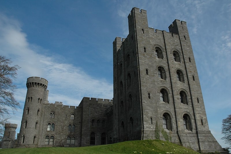
Building in Wales. Penrhyn Castle is a country house in Llandygai, Bangor, Gwynedd, North Wales, in the form of a Norman castle. It was originally a medieval fortified manor house, founded by Ednyfed Fychan. In 1438, Ioan ap Gruffudd was granted a licence to crenellate and he founded the stone castle and added a tower house. Samuel Wyatt reconstructed the property in the 1780s.
The present building was built between about 1822 and 1837 to designs by Thomas Hopper on behalf of its owner, who expanded and transformed the building beyond recognition. The owner of the castle had many slaves, and was compensated for being deprived of them after the abolition of slavery.[1]
Bangor Cathedral
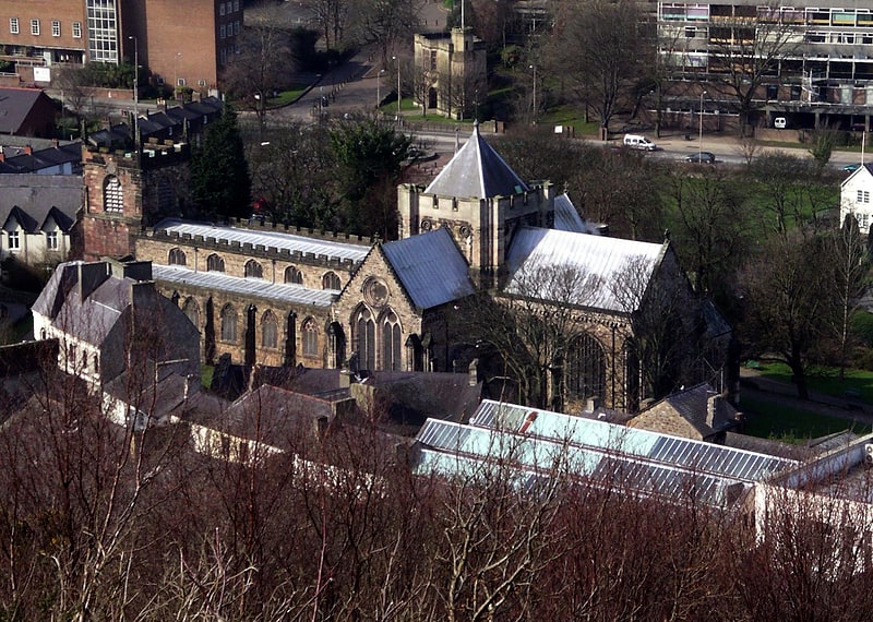
Cathedral in Bangor, Wales. Bangor Cathedral is a cathedral in Bangor, Gwynedd, Wales. It is dedicated to its founder, Saint Deiniol.
The site of the present building of Bangor Cathedral has been in use as a place of Christian worship since the 6th century. The cathedral was built on a low-lying and inconspicuous site, possibly so as not to attract the attention of Viking raiders from the sea in ancient times.
The Gothic style building on the hill is part of Bangor University.[2]
Address: Cathedral Close, LL57 1LH Bangor
Bangor Mountain
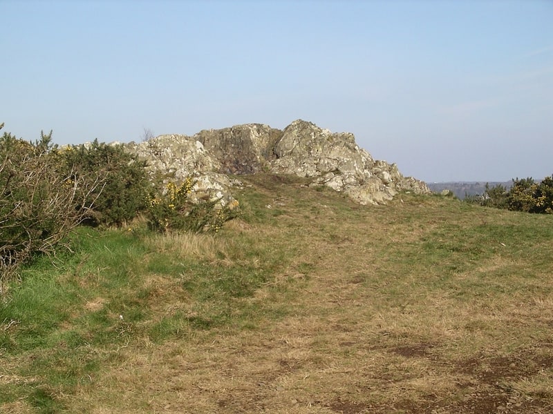
Mountain in Wales. Bangor Mountain is a scarp face of a hill below which the city of Bangor in Gwynedd, Wales, sits.
Though not a mountain in the true sense of the word it is so-called because of the way it rears up behind Bangor and appears mountainous, especially from the Glan Adda, High Street and Hirael areas of the city.
The north-facing part of the summit was worked up with a series of paths in the late 19th century when the area was promoted as 'the pleasure grounds' in tourism literature. The Mountain is much less precipitous on its southern side. Along a substantial part of the crest of the mountain is Bangor Golf Club more properly St Deiniol's Golf Club. Because of the shape of the mountain, the golf course is linear and crosses some lanes and minor roads, including Bishop's Mill Road which was once the main route into Bangor from the south. From the south, where access is permitted, there are fine views of Puffin Island, the Great Orme, parts of the coastline, and some of the (true) mountains of Snowdonia.
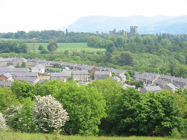
There are several rocky outcrops at high points on the mountain providing panoramic views of the city centre, the Menai Strait and over to the east of Anglesey, including the town of Beaumaris. This is probably the best location from which to see the buildings of the Bangor University and the cathedral as shown in the image below (the old Students Union building, and the former Theatr Gwynedd to the centre-left of this photo, have been replaced by the new Pontio building).
Along the side of the high street, the scarp slope is nearly vertical and clothed with trees. The slope is so severe and the mountain so close at the North end of the High Street, that one short section does not receive direct sunlight between November and February.
Bangor Mountain has a diverse ecology with a variety of mixed woods, open grassland and extensive areas of gorse although biodiversity appears to be significantly reduced within the confines of the golf course. To the north, there are some stands of Leycesteria formosa, and Japanese knotweed. The latter seems to have been present for many years without invading large areas. Around the rocky outcrops and alongside some of the many paths that weave their way around the mountain are large deposits of litter.
The extensive groves of gorse are often set alight by arsonists in dry summers producing a blaze that can be seen for many miles around. Whilst this may benefit the gorse and the ecosystem-based around gorse, the fires often spread into other areas of established woods where considerable damage is caused. These fires can also threaten gardens and outbuildings lining the base of the hill.
Bangor Mountain provides the main southern watershed for the River Adda, the principal river flowing through Bangor. However, as the river has now been culverted throughout its whole length in the built-up area of the city, it is little known to the city's population.
Part of Bangor Mountain was removed to provide car parking for a new discount supermarket. As a result, the footpath in this area now approaches very close to a precipitous edge protected by two-metre-high railings topped with sawtooth edging. The placement of the car park has occasionally led to vandals damaging parked cars utilising throwing rubble down from the footpath.[3]
Bangor University
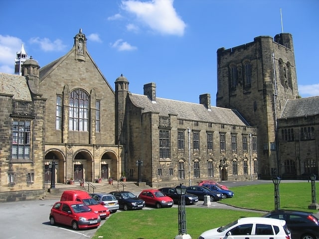
Public university in Bangor, Wales. Bangor University is a public university in Bangor, Wales. It received its Royal Charter in 1885 and was one of the founding institutions of the federal University of Wales. Officially known as University College of North Wales, and later University of Wales, Bangor, in 2007 it became Bangor University, independent from the University of Wales.[4]
Address: College Road, LL57 2DG Bangor
Port Penrhyn
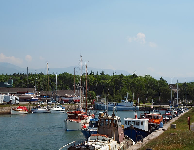
Port Penrhyn is a harbour located just east of Bangor in north Wales at the confluence of the River Cegin with the Menai Strait. It was formerly of great importance as the main port for the export of slate from the Penrhyn Quarry, the largest slate quarry in the world at the end of the nineteenth century. It was built, and later expanded, by the Pennant family of the nearby Penrhyn Castle.
Penrhyn is the Welsh word for 'promontory'.
The port is used by coastal vessels up to about 3,000 tonnes deadweight (DWT) and by fishing vessels.[5]
Afon Cegin
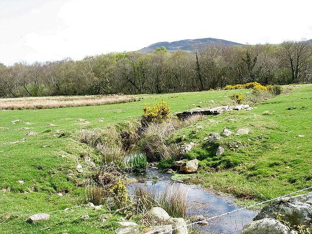
The Afon Cegin is a small river draining parts of North Wales and discharging to the Menai Strait at Porth Penrhyn. Its name means Kitchen River in English.[6]
University College of North Wales
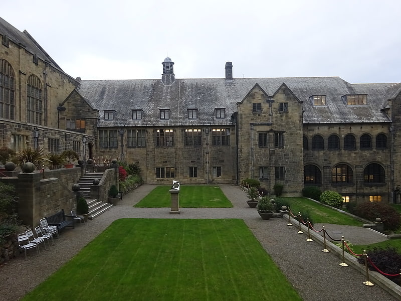
The original building for the University College of North Wales is a Grade I listed University building in the Collegiate Tudor style with Arts and Crafts influences. Designed by architect Henry Hare it was completed in 1911. The listed building record states that it is architecturally, one of the most significant public buildings of the period in Britain.
The building dominates the views of Bangor in Gwynedd, North Wales. Its highly visible location above the town meant that it became known, in Welsh as "Y Coleg ar y Bryn" (the College on the hill). The building contains the principal administrative areas of the university, in addition to the library, and the large Pritchard-Jones hall, named after Sir John Pritchard Jones.[7]
Garth Community Centre
Piers and boardwalks, Neighbourhood
Address: Garth Road, LL57 2SW Bangor
Garth Pier
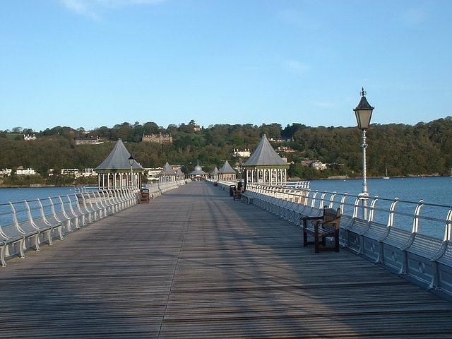
Tourist attraction in the United Kingdom. Garth Pier is a Grade II listed structure in Bangor, Gwynedd, Wales. At 1,500 feet in length, it is the second-longest pier in Wales, and the ninth longest in the British Isles.[8]
Maesgeirchen
Maesgeirchen is a large housing estate on the edge of the city of Bangor in Gwynedd, north-west Wales, with roughly 4,000 inhabitants.
It is the third-largest single housing estate in Wales behind Gurnos, Merthyr Tydfil, the second largest and Caia Park in Wrexham, which is the largest with nearly 12,000 inhabitants.
The estate is located away from Bangor's main spread, being separated by Bangor Mountain. The name of the estate is often shortened to a simpler "Maes-G" in casual use, by residents of both the estate and the city.
North it goes over Bangor Mountain towards the city and south it goes through the nearby Llandegai industrial estate. Recently there have been major environmental works throughout the river area including walkways, paths, and picnic areas designed for use by pedestrians and wheelchair users.
The estate also boasts its own residents' organisation and 'communities first' division which is run by locals. It has a community centre (Ty Cegin, built with National Lottery funding as a Healthy Living Centre and later taken over by the local Communities First Partnership following cessation of five years of lottery funding), It used to have a social club, which closed in 2014, although plans were made to demolish it and replace it with a Costcutter convenience store in 2020.[9]