Discover 9 hidden attractions, cool sights, and unusual things to do in Castleton (United Kingdom). Don't miss out on these must-see attractions: Peak Cavern, Treak Cliff Cavern, and Blue John Cavern. Also, be sure to include Mam Tor in your itinerary.
Below, you can find the list of the most amazing places you should visit in Castleton (England).
Table of Contents
Peak Cavern
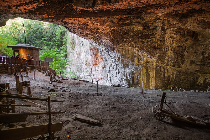
Cave in England. The Peak Cavern, also known as the Devil's Arse, is one of the four show caves in Castleton, Derbyshire, England. Peakshole Water flows through and out of the cave, which has the largest cave entrance in Britain.[1]
Treak Cliff Cavern
Tourist attraction in England. Treak Cliff Cavern is a show cave near Castleton in Derbyshire, England. It is part of the Castleton Site of Special Scientific Interest and one of only two sites where the ornamental mineral Blue John is still excavated. As part of an agreement with English Nature, the Blue John that can be seen in the show cave is not mined but it is extracted in small quantities from other areas of the cave and made into saleable items like bowls, jewellery and ornaments.
The cave comprises two sections, the Old Series, discovered by lead miners in the 18th century, and the New Series, discovered during blasting in the 1920s. Only the Old Series contains Blue John, but the New Series is well decorated with flowstone, stalagmites and stalactites. Three human skeletons and flint implements from the Neolithic era were found in a small cave nearby in 1921.[2]
Address: Buxton Road, S33 8WP Castleton
Blue John Cavern
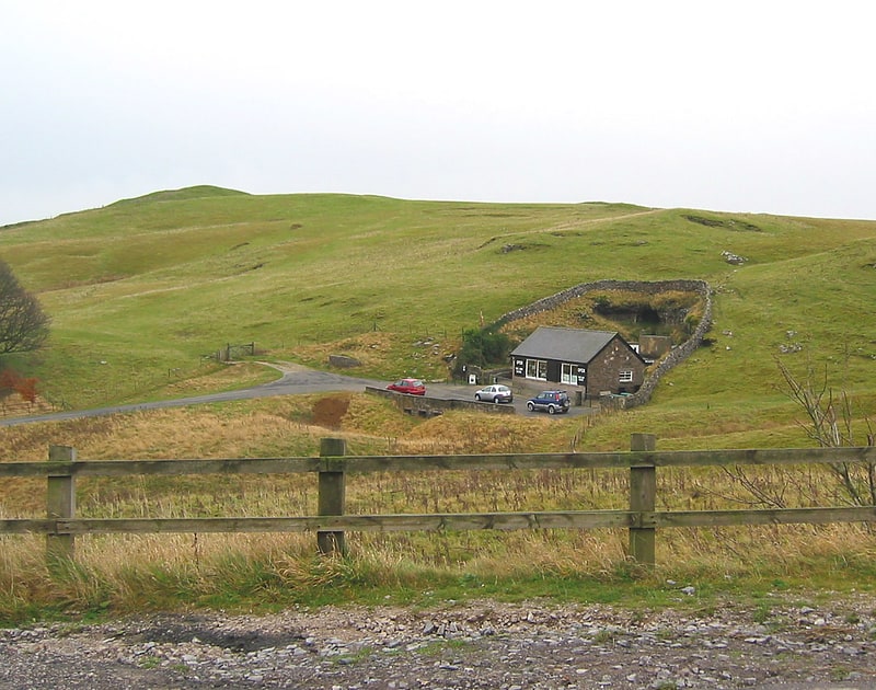
Tourist attraction in England. The Blue John Cavern is one of the four show caves in Castleton, Derbyshire, England.[3]
Address: Mam Tor, S33 8WA Castleton
Mam Tor
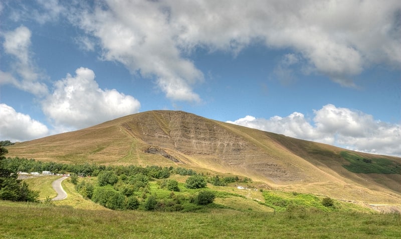
Hill in England. Mam Tor is a 517 m hill near Castleton in the High Peak of Derbyshire, England. Its name means "mother hill", so called because frequent landslips on its eastern face have resulted in a multitude of "mini-hills" beneath it. These landslips, which are caused by unstable lower layers of shale, also give the hill its alternative name of Shivering Mountain.
In 1979, the continual battle to maintain the A625 road (Sheffield to Chapel en le Frith) on the crumbling eastern side of the hill was lost when the road officially closed as a through-route, with the Fox House to Castleton section of the road being re-designated as the A6187.
The hill is crowned by a late Bronze Age and early Iron Age univallate hill fort, and two Bronze Age bowl barrows. At the base of the Tor and nearby are four show caves: Blue John Cavern, Speedwell Cavern, Peak Cavern and Treak Cliff Cavern where lead, Blue John, fluorspar and other minerals were once mined. Mam Tor was declared to be one of the Seven Wonders of the Peak by Thomas Hobbes in his 1636 book De Mirabilibus Pecci.
Simon Jenkins rates the panorama from Kinder Scout to Stanage Edge as one of the top ten in England.[4]
Peveril Castle
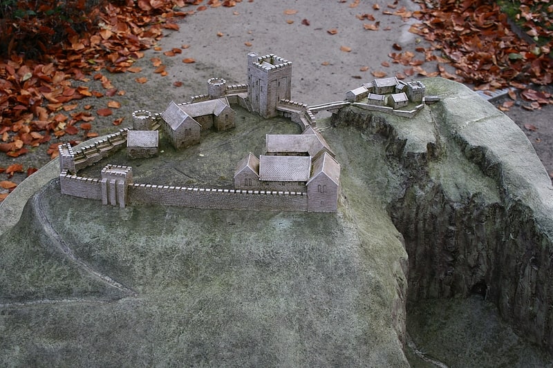
Ruined Norman fort in scenic location. Peveril Castle is a ruined 11th-century castle overlooking the village of Castleton in the English county of Derbyshire. It was the main settlement of the feudal barony of William Peverel, known as the Honour of Peverel, and was founded some time between the Norman Conquest of 1066 and its first recorded mention in the Domesday Survey of 1086, by Peverel, who held lands in Nottinghamshire and Derbyshire as a tenant-in-chief of the king. The town became the economic centre of the barony. The castle has views across the Hope Valley and Cave Dale.
William Peveril the Younger inherited his father's estates, but in 1155 they were confiscated by King Henry II. While in royal possession, Henry visited the castle in 1157, 1158, and 1164, the first time hosting King Malcolm IV of Scotland. During the Revolt of 1173–1174, the castle's garrison was increased from a porter and two watchmen to a force led by 20 knights shared with the castles of Bolsover and Nottingham. The Earls of Derby had a claim to the Peveril family's estates through marriage, and in 1199 William de Ferrers, the fourth earl, paid 2,000 marks for the Peak lordship, although the castle remained under royal control. The closest Peveril Castle came to seeing battle was in 1216, when King John gave the castle to William de Ferrers, but the castellan refused to relinquish control. Although they were both John's supporters, the king authorised the earl to use force to evict the castellan, who eventually capitulated, although there is no evidence that the castle was assaulted.
In 1223 the castle returned to the Crown. In the 13th century there were periods of building work at the castle, and by 1300 its final form had been established. Toward the end of the 14th century, the barony was granted to John of Gaunt, Duke of Lancaster. Having little use for the castle, he ordered some of its material to be stripped out for re-use, marking the beginning of its decline. From the time of John of Gaunt to the present day, the castle has been owned and administered by the Duchy of Lancaster. Peveril Castle became less important administratively, and by 1609 it was "very ruinous and serveth for no use". In the 19th century, Sir Walter Scott featured the castle in his novel Peveril of the Peak. The site is situated in a national park, and cared for by English Heritage. Peveril Castle is protected as a scheduled monument and a Grade I listed building.[5]
Address: Market Pl, S33 8WQ Castleton
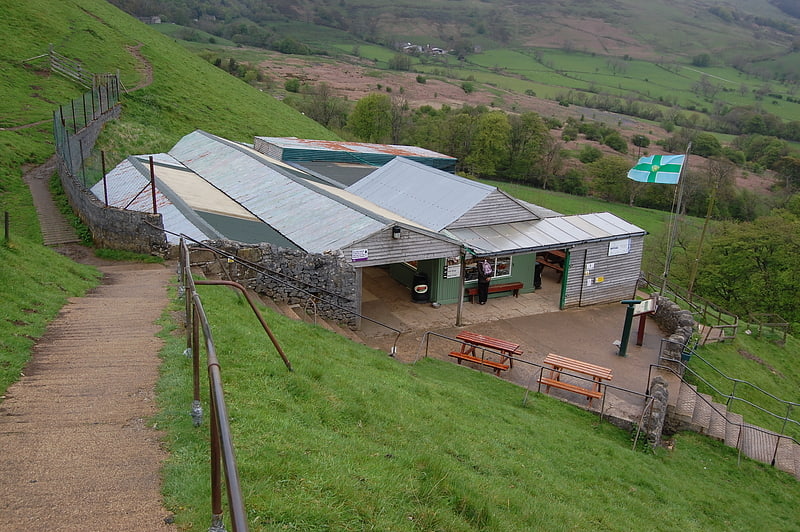
Speedwell Cavern
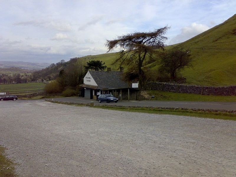
Cave in England. Speedwell Cavern is one of the four show caves in Castleton, Derbyshire, England.
The cave system consists of a horizontal lead miners' adit (a level passageway driven horizontally into the hillside) 200 metres below ground leading to the cavern itself, a limestone cave. The narrow adit is permanently flooded, so after descending a long staircase, access to the cave is made by boat. At the end of the adit, the cavern opens up with fluorspar veins, stalactites and stalagmites, and the so-called "Bottomless Pit". This chamber has an underground lake with a 20 metres (66 ft) high waterfall and an extremely deep vertical shaft, now choked to within 20 metres (66 ft) of the surface by rock spoil dumped by miners. The original depth of the shaft has been estimated, from the amount of spoil placed in the shaft over the years, at around 150 metres (490 ft).
The mine was developed in the 1770s but the limited lead ore deposits meant that it was not profitable and it was closed down by 1790.
At the foot of Winnats Pass, it is a tourist attraction with an underground boat trip to the cavern. Originally the guide propelled the boat by pushing against the walls with his hands, later the boat was legged through, and now it is powered by an electric motor.
A connection was discovered in 2006 between the Speedwell Cavern system and Titan, the largest natural shaft in the UK, which is 141.5 metres (464 ft) high.[6]
Address: Speedwell Cavern Winnat's Pass, S33 8WA Castleton
Cave Dale
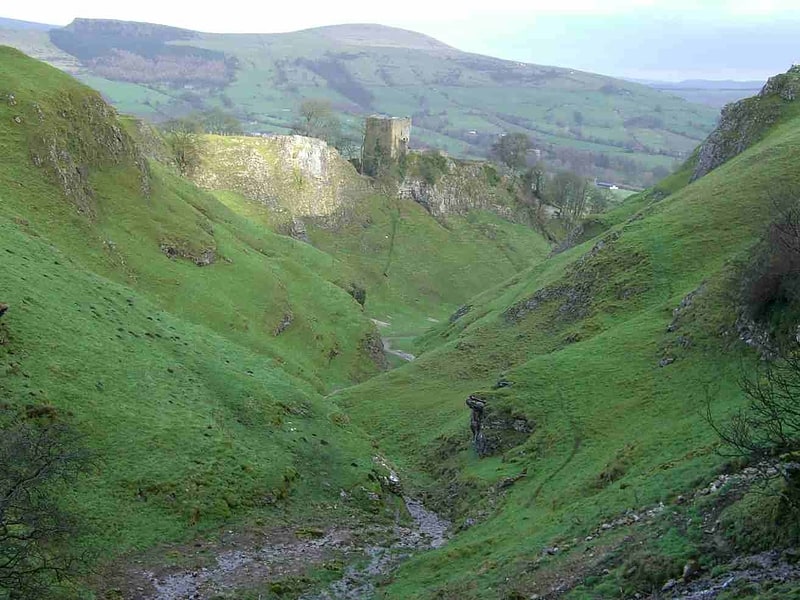
Landmark in England. Cave Dale is a dry limestone valley in the Derbyshire Peak District, England. It is located at grid reference SK149824. The northern end of the dale starts at the village of Castleton where the valley sides are almost perpendicular and over 50 metres in height. The dale rises gently after leaving Castleton for approximately 200 metres before becoming steeper culminating in a fine viewpoint down the dale taking in Peveril Castle with Lose Hill behind. After the viewpoint the dale swings west and levels out with gentle gradients, becoming just a shallow depression as it peters out onto the open pastureland between Castleton and Chapel-en-le-Frith.
Cave Dale was initially formed by glacial meltwater carving a deep narrow valley in the local soluble limestone. The river then found a route underground leaving a dry valley with caverns underneath. Later on the caverns below Cave Dale collapsed making the valley even deeper and gorge-like at the northern end. The Castleton entrance to Cave Dale had a narrow natural arch as recently as 200 years ago, a relic of the roof collapse. The lower slopes of the dale have large amounts of scree, frost on the higher limestone cliffs having caused the rock to shatter. Halfway up the valley is an outcrop of basaltic lava with a few small columns.
A bridleway runs the entire length of the dale, part of the Limestone Way footpath which travels 80 kilometres from Castleton to Rocester in Staffordshire. Cave Dale is accessed through a narrow rocky opening almost from the centre of Castleton, and Peveril Castle is seen high up on the almost vertical western slopes. The Normans chose this site because the steep sides of Cave Dale gave a natural defence and good lookout.
The chambers and caves of Peak Cavern run directly below Cave Dale and any small streams in the dale quickly disappear into the ground down limestone fissures and into the caverns beneath. Mineral veins can also be seen within the limestone of the dale. The cliffs at the northern end of Cave Dale are used by rock climbers and there are several routes in the Very Severe category. There are several small caves or old lead mines within the dale's limestone walls, one being larger than the rest with bars preventing access. Cave Dale's steep north-facing grassy slopes are damp and bryophyte-rich and are dominated by oat grass (Trisetum flavescent) and sheep's fescue (Festuca ovina). Lesser meadow-rue (Thalictrum minus) grows extensively on ledges in the dale.
At the southwestern extremity of the dale as it merges into the moorland between Castleton and Peak Forest are the remains of several old lead mines. The Hazard Mine lies at grid reference SK136812, and was one of the major mines of the area. Over 5000 tonnes of lead ore were mined and the main shaft goes down 700 feet (210 m). The Hollandtwine Mine lies 250 metres (820 ft) to the east. Drainage from both mines went directly into Peak Cavern.
In 1983 Cave Dale was the scene of the murder of a 21-year-old Manchester Polytechnic student, Susan Renhard. Norman Smith, a local 17-year-old, was subsequently jailed for life at Nottingham Crown Court in 1984.
Cave Dale features in the films The Princess Bride (1987) and The Other Boleyn Girl (2008).[7]
St Edmund's Church
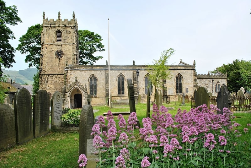
Parish church in Castleton, Derbyshire, England. St Edmund's Church, Castleton, is a Grade II* listed parish church in the Church of England in Castleton, Derbyshire.[8]
Peakshole Water
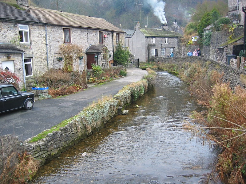
Stream in England. Peakshole Water is a stream in the Derbyshire Peak District named after its source, Peak Cavern. It flows through the village of Castleton to join the River Noe in nearby Hope. Despite its name, much of its flow actually emerges from the Russet Well, a resurgence in a garden on the east side of the gorge below the main Peak Cavern entrance, described as the "main resurgence of the Castleton area", which drains a series of swallets on the other side of the Pennine watershed below Rushup Edge. The resurgence has been explored by cave divers to a depth of 82 feet but further exploration was halted by a constriction.
The River Noe flows into the Derbyshire Derwent, which in turn leads to the River Trent and thence to the Humber estuary and the North Sea.
The stream once powered a corn mill in Castleton which remained in use until about 1920. The 10–12ft diameter water wheel survived until the 1950s. Little is left of the mill, apart from the wheel pit and the mill pond. A public footpath leads from Castleton past the mill and follows close to the stream as far as Pindale Road south of Hope. The stream has one main tributary, Odin Sitch, which rises above Odin Mine on the slopes of Mam Tor and joins Peakshole Water north of the visitor centre in Castleton.[9]