Discover 8 hidden attractions, cool sights, and unusual things to do in Thorold (Canada). Don't miss out on these must-see attractions: Welland Canal Bridge 11, Welland Canal, and Lake Gibson. Also, be sure to include Welland Recreational Waterway in your itinerary.
Below, you can find the list of the most amazing places you should visit in Thorold (Ontario).
Table of Contents
Welland Canal Bridge 11

Vertical-lift bridge. Bridge 11, also known as the Allanburg Bridge, is a vertical-lift bridge over the Welland Canal within the City of Thorold and community of Allanburg, Ontario, Canada. The location was used for the groundbreaking ceremony for the canal. It was constructed and completed in 1930. The bridge carries Hwy 20 connecting Niagara Falls to Fonthill.
The bridge has a 60.9-metre (200 ft) main span. It was designed by Harrington, Howard & Ash, the predecessor of HNTB. It was rehabilitated in 2001 and is a through-truss vertical-lift bridge with 36.5 m (119.8 ft) clearance for shipping.
On August 11, 2001, the bridge was struck by the MS Windoc (1959) when the lift span was lowered before the ship cleared the structure. The ship caught fire. After minor repairs to the bridge, it reopened to vehicular traffic on November 16, 2001.[1]
Welland Canal
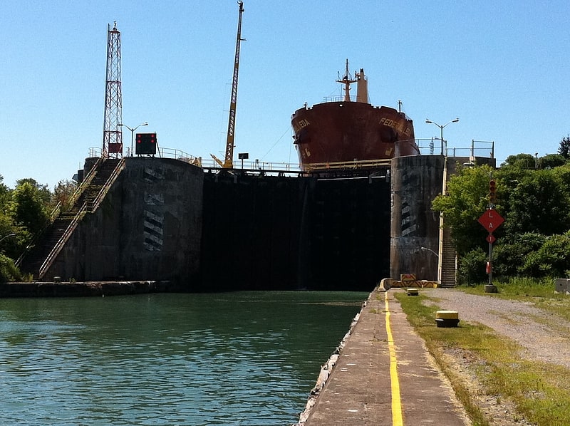
Canal in Ontario, Canada. The Welland Canal is a ship canal in Ontario, Canada, connecting Lake Ontario and Lake Erie. It forms a key section of the St. Lawrence Seaway and Great Lakes Waterway. Traversing the Niagara Peninsula from Port Weller in St. Catharines to Port Colborne, it enables ships to ascend and descend the Niagara Escarpment and bypass Niagara Falls. It is the fourth canal connecting these waterways; three smaller predecessors also bore the same name.
The Welland Canal passes about 3,000 ships which transport about 40,000,000 tonnes (39,000,000 long tons; 44,000,000 short tons) of cargo a year. It was a major factor in the growth of the city of Toronto, Ontario. The original canal and its successors allowed goods from Great Lakes ports such as Cleveland, Detroit, Milwaukee, and Chicago, as well as other heavily industrialized areas of the United States and Ontario, to be shipped to the port of Montreal or to Quebec City, where they were usually reloaded onto ocean-going vessels for international shipping.
The Welland Canal eclipsed other, narrower canals in the region, such as the Trent-Severn Waterway and, significantly, the Erie Canal (which linked the Atlantic and Lake Erie via New York City and Buffalo, New York) by providing a shorter, more direct connection to Lake Erie.
The southern, Lake Erie terminus of the canal is 99.5 metres (326 feet) higher than the northern terminus on Lake Ontario. The canal includes eight 24.4-metre-wide (80 ft) ship locks. Seven of the locks (Locks 1–7, the 'Lift' locks) are 233.5 m (766 ft) long and raise (or lower) passing ships by between 13 and 15 m (43 and 49 ft) each. The southernmost lock, (Lock 8 – the 'Guard' or 'Control' lock) is 349.9 m (1,148 ft) in length. The Garden City Skyway passes over the canal, restricting the maximum height of the masts of the ships allowed on this canal to 35.5 m (116 ft).
All other highway or railroad crossings of the Welland Canal are either movable bridges (of the vertical lift or bascule bridge types) or tunnels. The maximum permissible length of a ship in this canal is 225.5 metres (740 feet). It takes ships an average of about eleven hours to traverse the entire length of the Welland Canal.[2]
Lake Gibson
Lake in Ontario, Canada. Lake Gibson is a lake near Thorold in the Regional Municipality of Niagara, Ontario, Canada. The lake is not natural, but rather was created as a reservoir for hydroelectric power generation at the Ontario Power Generation Decew Falls 1 and Decew Falls 2 generating stations. The lake was created by flooding the shallow valley of Beaverdams Creek. Lake Moodie is located to the northwest of Lake Gibson and is a smaller segment of the overall Lake Gibson system. Almost all of the water supply to these lakes comes from Lake Erie via the Welland Canal. The lakes suck part of the Twelve Mile Creek watershed.
Highway 406 crosses over the lake. At the west end of the lake is Morningstar Mill, consisting of a working gristmill dating from 1872, plus a reconstructed sawmill. A short distance east of this are the ruins of DeCou House, the destination of Laura Secord's famous journey during the War of 1812.
Lake Gibson is part of St. Catharines' drinking water supply. Consequently, no boating is permitted.[3]
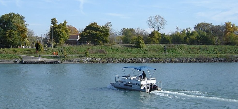
Welland Recreational Waterway

The Welland Recreational Waterway is a water channel in the city of Welland, Ontario, Canada. It is an old alignment of the Welland Ship Canal that was abandoned after the construction of the Welland By-Pass in the 1970s. The Waterway is now managed by the Welland Recreational Canal Corporation to provide enjoyment for the city's residents. Most local residents refer to it as the old canal or simply the canal.[4]
Allanburg
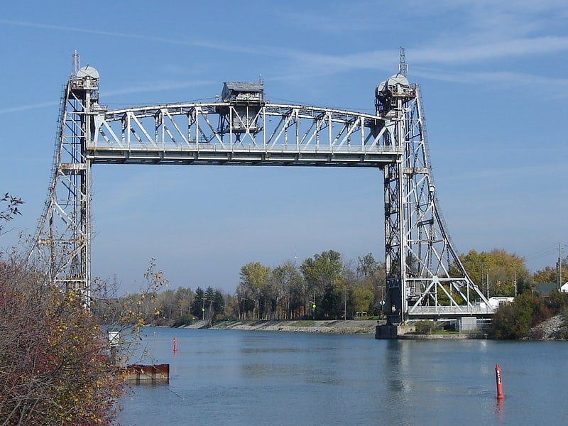
Allanburg is a community within the City of Thorold, Ontario, Canada. It is located on the Welland Canal and Highway 20, both important transportation routes through the Niagara Peninsula. The two cross at a vertical-lift bridge, numbered as Bridge 11 by the Saint Lawrence Seaway Authority, but often known simply as the Allanburg Bridge. The collision of the ship Windoc with the bridge made national news in 2001.[5]
Short Hills Provincial Park
Provincial park in Ontario, Canada. Short Hills Provincial Park is a provincial park located in the centre of the Niagara Peninsula, bordering the city of St. Catharines and the town of Pelham in the Niagara Region in southern Ontario, Canada. It occupies an area of 660 hectares. It also borders the new vineyard sub-appellation called the Short Hills Bench.
Located on the southern edge of the Niagara Escarpment, the park is a jumble of small but steep hills ("short hills") and valleys created by the last ice age. The effect was only compounded when the Twelve Mile Creek cut through the sedimentary deposits and glacial till.
Wildlife inhabiting the park include white-tailed deer, coyote, and meadow vole. Being at the north end of the Carolinian zone, many plants grow here that do not grow or are rarely found in other parts of Canada, including pawpaw, sweet chestnut and tulip-tree.
The only park of its scale in Niagara, Short Hills Provincial Park is a prime destination for residents of nearby cities, especially St. Catharines and Niagara Falls. Popular activities include hiking, horseback riding, fishing and mountain biking.
The park contains six-side trails including the Bruce Trail and several waterfalls, it has a nice mix of both dense forests and open meadows, with meandering creeks and gentle hills that offer good hiking conditions.[6]
Thorold Tunnel
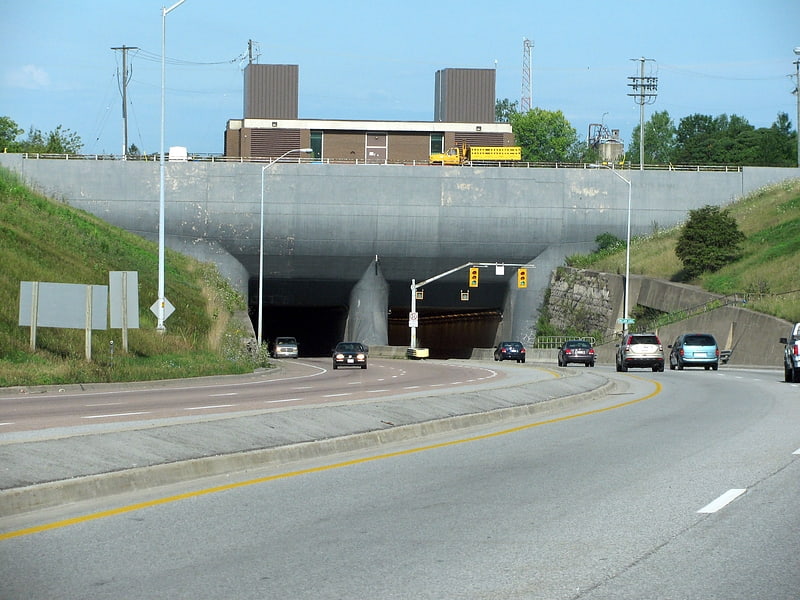
The Thorold Tunnel is an underwater tunnel in Thorold, Ontario, Canada carrying Highway 58 underneath the Welland Canal. Built between 1965 and 1967, the tunnel is 840 metres in length and consists of two separate tubes each containing two lanes of traffic. The westbound tube has a sidewalk for pedestrians.
It is one of three tunnels under the Welland Canal (the other two being the Main Street and Townline Tunnels in Welland), and the only tunnel to be constructed after the waterway opened.
The tunnel has been used as a filming location due to its relatively low traffic levels, including for the television series American Gothic and the movie Highwaymen.
Due to repair work on the tunnel's ceiling tiles, the Ontario Ministry of Transportation began daily closures of the westbound tube in April 2018 outside of morning rush hour. The repairs are an interim measure and a tender for full rehabilitation of the tunnel was issued by the Ministry on April 4, 2018.[7]
Port Robinson
Port Robinson is a small community in the southernmost part of Thorold, Ontario, Canada. The community is divided in half by the Welland Canal, as there is no bridge in the immediate vicinity to connect the two halves of the community. In the summer, a small free ferry for pedestrians and cyclists runs across the canal. In the winter, residents must use the bridge on Highway 20, which results in a 13.3 km trip to get to the other side.
Like all the ports on the first Welland Canal, Port Robinson was named after a member of the Family Compact that once ruled Upper Canada, as Ontario was then named. Sir John Beverly Robinson was Attorney General of Upper Canada at the time the first Canal was built, and the port was originally named Port Beverly. The post office dates from 1835 onward.[8]