Discover 35 hidden attractions, cool sights, and unusual things to do in Hamilton (Canada). Don't miss out on these must-see attractions: Webster's Falls, Tew's Falls, and Canadian Warplane Heritage Museum. Also, be sure to include Albion Falls in your itinerary.
Below, you can find the list of the most amazing places you should visit in Hamilton (Ontario).
Table of Contents
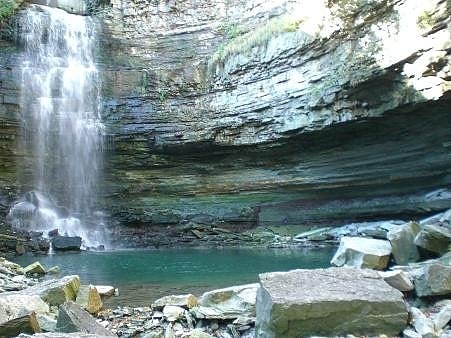
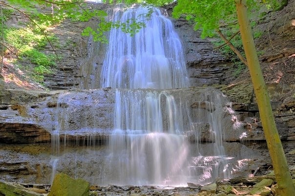
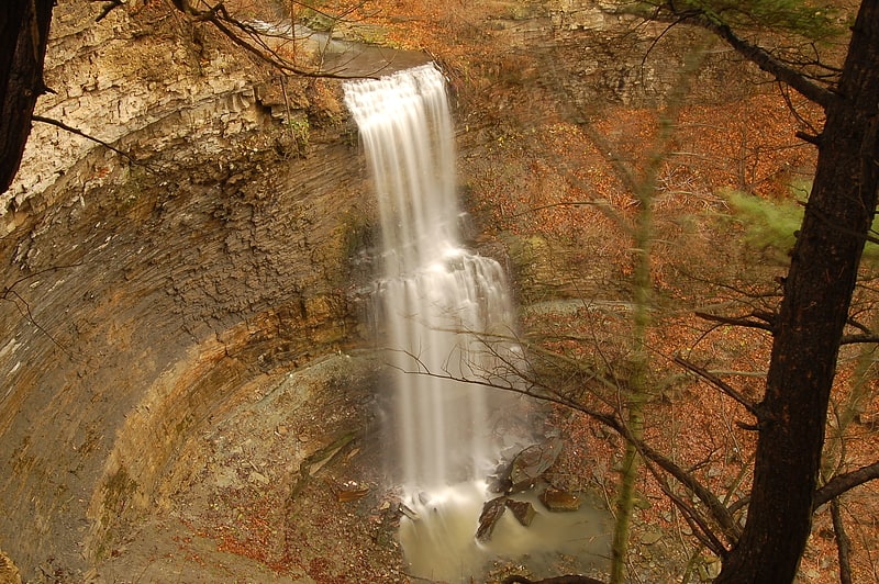
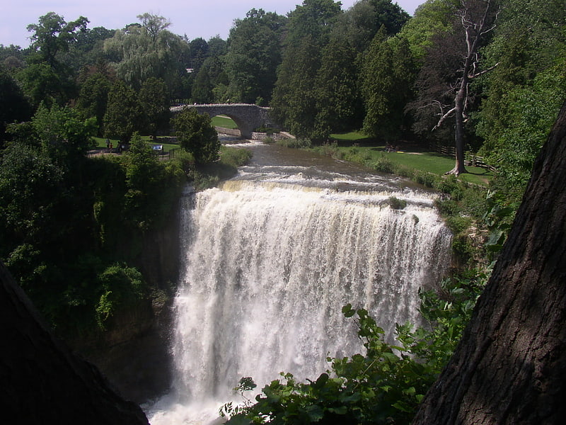
Webster's Falls
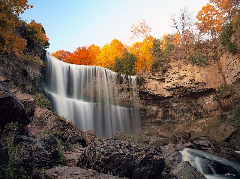
Waterfall in Ontario, Canada. Webster's Falls, noted for its panoramas, is a 22-metre-high classical curtain/ plunge waterfall found in the Spencer Gorge/Webster's Falls Conservation Area in Hamilton, Ontario, Canada. The water flows down Spencer Creek. In the past the falls have been known by various names such as Dr. Hamilton's Falls, Spencer Falls, Hart Falls, Fisher Falls and Flamborough Falls.
The cobblestone footbridge, as well as a newer and narrower stone/concrete footbridge, crosses over Spencer Creek to the west side. A shuttle service now runs between a large parking area just outside Dundas and Spencer Gorge/Webster Falls Conservation Area, for visitors to access this popular conservation area on weekends and holidays from Saturday, May 13 to Sunday, October 29, 2017.[1]
Address: 99-367 Fallsview Rd, Hamilton (Greensville)
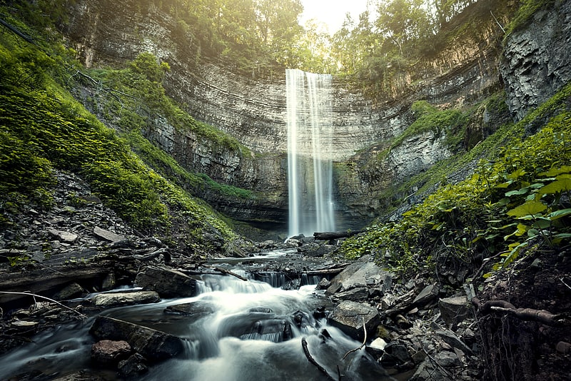
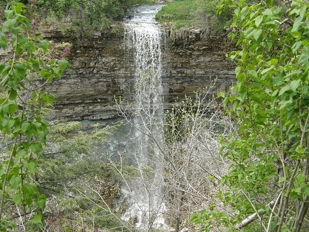
Tew's Falls
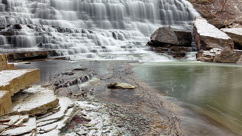
Waterfall in Ontario, Canada. The city of Hamilton in Ontario, Canada is home to more than 100 waterfalls and cascades, most of which are on or near the Bruce Trail as it winds through the Niagara Escarpment. Ontario's internationally recognized Niagara Escarpment provides perfect geological conditions for waterfalls to occur, from Tobermory to Niagara Falls.
The most scenic waterfall in Hamilton is Webster's Falls. With its 30 metres (98 ft) crest, it is the largest waterfall within the city. Tew's Falls is a 41 metres (135 ft) ribbon waterfall, and is the tallest waterfall found in Hamilton. Both Webster's and Tew's are located at the Spencer Gorge / Webster's Falls Conservation Area. Albion Falls was once seriously considered as a possible source of water for Hamilton. Rocks from the Albion Falls area were used in the construction of the Royal Botanical Gardens' Rock Garden.
There used to be more waterfalls in Hamilton than exist today. Many of the waterfalls in central Hamilton slowly vanished as population and construction on Hamilton Mountain increased. As well, in the early years, James Street extended south, but was interrupted by a bog at Hunter Street which eventually (1844) was drained out and graded. Many of Hamilton's main buildings and factories in the north end are built on reclaimed or infilled land, which harmed the drainage of Hamilton and the water ecology of Hamilton Harbour.
Many of the falls in west Hamilton are accessible from the Chedoke Radial Trail. It is built on what was once the route for the Brantford and Hamilton Electric Railway owned by the Cataract Power Light and Traction Company (later Dominion Power and Transmission). The "Five Johns", (John Cameron, John Dickenson (Canadian politician), John Morison Gibson, John Moodie, Sr. and John Sutherland), formed The Cataract Power Co. Ltd. introducing electric power to Hamilton in 1898. On August 25, 1898, power was sent twenty seven miles from DeCew Falls, St. Catharines, using water from the old Welland Canal. New industries, such as the forerunners of the Steel Co. of Canada (Stelco) and Canadian Westinghouse, were attracted here by the cheaper, more efficient power. One time this Company controlled hydro power from Brantford to St. Catharines, including the Hamilton Street Railway and the area's radial lines. Back then the city's nickname was "The Electric City."
There are four waterfall types and they are designated as follows:
- Ribbon – height is notably greater than its crest width; stream forms a thin ribbon of water.
- Classical – height and crest width are nearly equal.
- Curtain – height is notably smaller than its crest width.
- Cascade – vertical drop is broken into a series of steps causing water to cascade down incline.
Some of the criteria used to define a separate Hamilton waterfall include: The waterfall has to have a vertical drop of at least 3 metres or 10 feet (3.0 m) either as a vertical drop or a cascade, the crest width has to be at least 1 metre or 3 feet (0.91 m) wide, the waterfall must have some natural component and not be entirely man-made; If a waterfall is beside another waterfall but coming from two separate creeks or streams, then they could be considered as two separate waterfalls and the waterfall has to be located within the boundaries of the new City of Hamilton.
On January 1, 2001 the new city of Hamilton was formed from the amalgamation of the Regional Municipality of Hamilton-Wentworth and its six municipalities: Hamilton, Ancaster, Dundas, Flamborough, Glanbrook, and Stoney Creek. Before amalgamation, Hamilton had a population of 331,121 divided into 100 neighbourhoods. The new amalgamated city had 490,268 people in over 200 neighbourhoods.[2]
Address: Harvest Rd., Greensville, Hamilton (Greensville)
Canadian Warplane Heritage Museum
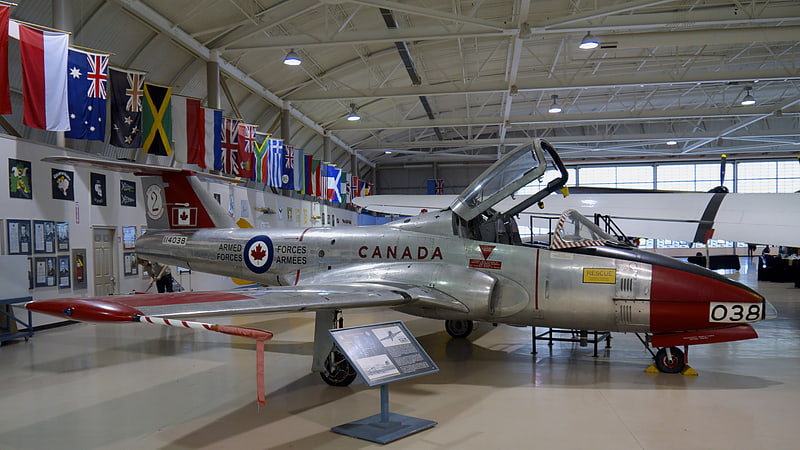
Museum in Hamilton, Ontario. The Canadian Warplane Heritage Museum is an aviation museum located at the John C. Munro Hamilton International Airport in Mount Hope, Ontario, Canada. The museum has 47 military jets and propeller-driven aircraft on display.
Displayed is a collection of Canadian military aircraft, many in flying condition. The museum is also restoring several Second World War and Cold War aircraft, including a TBM Avenger a De Havilland Canada built S-2 Tracker and a Bristol Bolingbroke. The flying collection performs at air shows and is made available for local flights by museum visitors.
The Avro Lancaster flown by the museum is one of only two airworthy Lancasters in the world. Known as the Mynarski Memorial Lancaster in honour of Pilot Officer Andrew Charles Mynarski, it is painted in the markings of his aircraft.[3]
Address: 9280 Airport Rd, L0R 1W0 Mount Hope (Rural Glanbrook)
Albion Falls
Waterfall in Ontario, Canada. Albion Falls is a 19 m classical/cascade waterfall flowing down the Niagara Escarpment in Red Hill Valley, in Hamilton, Ontario, Canada. With cascade falls the downpour is staggered into a series of steps causing water to "cascade". The top of the falls are located on Mountain Brow Blvd. The lower-end of the falls can be found at the south-end of King's Forest Park in lower Hamilton by following the Red Hill Creek south towards the Niagara Escarpment.
Albion Falls was once seriously considered as a possible source of water for Hamilton. Rocks from the Albion Falls area were used in the construction of the Royal Botanical Gardens' Rock Garden.
The ravine at the Albion Falls has a legend of the Lover's Leap. The story is that early in the 19th century young Jane Riley, disappointed in love with Joseph Rousseau, stood at the top of a steep cliff not far from thundering Albion Falls and flung herself to the bottom 100 ft (30 m) below. The steep drop has since been dubbed "Lovers' Leap" and many tales have grown up about the suicide.
Nearby attractions include the Bruce Trail, Buttermilk Falls, Devil's Punch Bowl, Felker's Falls, Confederation Park (via Red Hill Trail), Mohawk 4 Ice Centre at Mohawk Sports Park, scenic views of lower Hamilton, King's Forest Golf Course and Park, Gage Park and Hamilton Children's Museum.[4]
Address: Mountain Brow Blvd, Hamilton
Canadian Football Hall of Fame
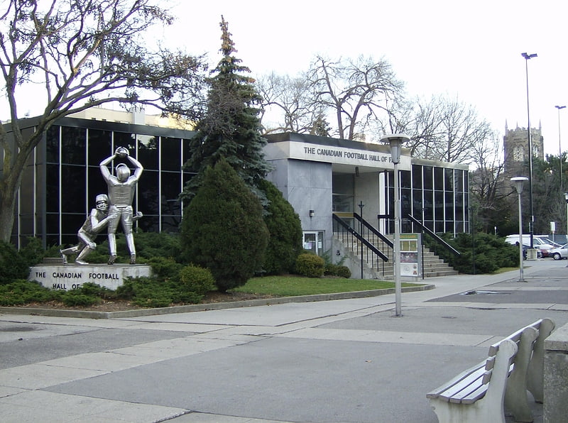
Museum in Hamilton, Ontario. The Canadian Football Hall of Fame is a not-for-profit corporation, located in Hamilton, Ontario, that celebrates great achievements in Canadian football. It is maintained by the Canadian Football League. It includes displays about the CFL, Canadian university football and Canadian junior football history.
The Hall previously had a main feature in the central portion of the museum where inducted members, each with a metal bust depicting their head, were displayed prior to the physical building being closed. There were also featured displays that highlight each CFL team's history, and an interactive Field goal kicking exhibit. The CFHOF is currently changing to a de-centralized model, which does not included a main museum building (see "Today" below).
Once during every CFL season, the Hall sponsors the induction ceremony of former players. Included in the "Hall of Fame Weekend" is a regular season game, usually (but not always) affiliated with the Hamilton Tiger-Cats. Traditionally, the inducted players will come to the Hall and make an acceptance speech in front of the building where their newly sculpted bust is unveiled. A player must be retired from the game for at least three years before being eligible for consideration. A Hall of Fame voting committee is composed of sports writers, selected CFL executives and inducted members.[5]
Address: 58 Jackson St W, L8P 1L4 Hamilton (Downtown Hamilton)
Devil's Punch Bowl
Waterfall in Ontario, Canada. Devil's Punch Bowl is a 37-metre ribbon waterfall on the Niagara Escarpment, in the Stoney Creek community of Hamilton, Ontario, Canada. It is found in the Devil's Punchbowl Conservation Area, maintained by the Hamilton Conservation Authority, and features an escarpment access trail with connections to a recently improved section of the Bruce Trail. Stoney Creek's Dofasco 2000 Trail is nearby. The Punch Bowl is also known as Horseshoe Falls for the distinctive shape of the cliff-face, which somewhat resembles its much larger cousin in Niagara Falls.
In addition to the 800 km-long Bruce Trail, nearby attractions include the historic Battlefield House Museum and Nash-Jackson House; on Lake Ontario, Fifty Point Conservation Area and Confederation Park; and Mohawk Sports Park and the Hamilton Museum of Steam & Technology in the city proper. There's also a convenience store, restaurant, motel, gas station and retail stores nearby.
Lower Punch Bowl Falls is a curtain waterfall located a few metres north of the Punch Bowl, spanning 7 metres in height and width.[6]
Address: Ridge Rd., Hamilton (Rural Stoney Creek)
FirstOntario Centre
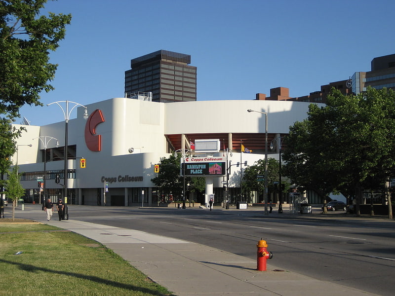
Sports arena in Hamilton, Ontario. FirstOntario Centre is a sports and entertainment arena at the corner of Bay Street North and York Boulevard in Hamilton, Ontario, Canada. Opened in 1985, it has a capacity of up to 19,000.[7]
Address: Hamilton, 101 York Boulevard
Tiffany Falls
Waterfall in Ontario, Canada. The city of Hamilton in Ontario, Canada is home to more than 100 waterfalls and cascades, most of which are on or near the Bruce Trail as it winds through the Niagara Escarpment. Ontario's internationally recognized Niagara Escarpment provides perfect geological conditions for waterfalls to occur, from Tobermory to Niagara Falls.
The most scenic waterfall in Hamilton is Webster's Falls. With its 30 metres (98 ft) crest, it is the largest waterfall within the city. Tew's Falls is a 41 metres (135 ft) ribbon waterfall, and is the tallest waterfall found in Hamilton. Both Webster's and Tew's are located at the Spencer Gorge / Webster's Falls Conservation Area. Albion Falls was once seriously considered as a possible source of water for Hamilton. Rocks from the Albion Falls area were used in the construction of the Royal Botanical Gardens' Rock Garden.
There used to be more waterfalls in Hamilton than exist today. Many of the waterfalls in central Hamilton slowly vanished as population and construction on Hamilton Mountain increased. As well, in the early years, James Street extended south, but was interrupted by a bog at Hunter Street which eventually (1844) was drained out and graded. Many of Hamilton's main buildings and factories in the north end are built on reclaimed or infilled land, which harmed the drainage of Hamilton and the water ecology of Hamilton Harbour.
Many of the falls in west Hamilton are accessible from the Chedoke Radial Trail. It is built on what was once the route for the Brantford and Hamilton Electric Railway owned by the Cataract Power Light and Traction Company (later Dominion Power and Transmission). The "Five Johns", (John Cameron, John Dickenson (Canadian politician), John Morison Gibson, John Moodie, Sr. and John Sutherland), formed The Cataract Power Co. Ltd. introducing electric power to Hamilton in 1898. On August 25, 1898, power was sent twenty seven miles from DeCew Falls, St. Catharines, using water from the old Welland Canal. New industries, such as the forerunners of the Steel Co. of Canada (Stelco) and Canadian Westinghouse, were attracted here by the cheaper, more efficient power. One time this Company controlled hydro power from Brantford to St. Catharines, including the Hamilton Street Railway and the area's radial lines. Back then the city's nickname was "The Electric City."
There are four waterfall types and they are designated as follows:
- Ribbon – height is notably greater than its crest width; stream forms a thin ribbon of water.
- Classical – height and crest width are nearly equal.
- Curtain – height is notably smaller than its crest width.
- Cascade – vertical drop is broken into a series of steps causing water to cascade down incline.
Some of the criteria used to define a separate Hamilton waterfall include: The waterfall has to have a vertical drop of at least 3 metres or 10 feet (3.0 m) either as a vertical drop or a cascade, the crest width has to be at least 1 metre or 3 feet (0.91 m) wide, the waterfall must have some natural component and not be entirely man-made; If a waterfall is beside another waterfall but coming from two separate creeks or streams, then they could be considered as two separate waterfalls and the waterfall has to be located within the boundaries of the new City of Hamilton.
On January 1, 2001 the new city of Hamilton was formed from the amalgamation of the Regional Municipality of Hamilton-Wentworth and its six municipalities: Hamilton, Ancaster, Dundas, Flamborough, Glanbrook, and Stoney Creek. Before amalgamation, Hamilton had a population of 331,121 divided into 100 neighbourhoods. The new amalgamated city had 490,268 people in over 200 neighbourhoods.[8]
Address: 936 Wilson St E, Hamilton (Ancaster)
Gage Park
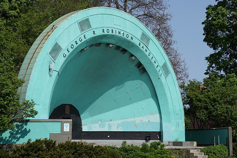
Gage Park is a large community park and civic gardens located in Hamilton, Ontario, Canada. It is located at the intersection of Main Street and Gage Avenue in East Hamilton.
Gage Park is the usual site of gay pride in this part of the city. The park hosts the annual Festival of Friends event in the first week of August. The park is also the site of the Hamilton Children's Museum.
The park includes a bandshell, fountain, and a greenhouse constructed in late 2020.
It is in the top three parks in Hamilton, in terms of urban parkland. The park is most famous for hosting "Movie In The Park" nights.[9]
Address: 222 Gage Ave. S., L8M 3M4 Hamilton
Battlefield House
Museum in Hamilton, Ontario. Battlefield House near King Street East and Centennial Parkway in Stoney Creek, Hamilton, Ontario, Canada is a living history museum and site of the historic Battle of Stoney Creek on June 6, 1813, which was fought during the War of 1812. It was built in 1796. The house and 15.5 acres of parkland, were the property of the Women's Wentworth Historical Society, and given by this society to the Niagara Parks Commission on January 19, 1962. The park was designated a National Historic Site of Canada in 1960.
Nestled under the Niagara Escarpment, this historic site is located on 32 acres (12.9 ha) of park land linked to the Bruce Trail. Also located on the property are the Battlefield Monument and the Grandview (Nash-Jackson House) building. Smith's Knoll Cemetery is also nearby, across King Street East from the park. During the first weekend in June, a re-enactment of the Battle of Stoney Creek is held with re-enactors in full regalia, representing both the British and American sides. The 2016 event was the 35th such re-enactment.
British units made a night attack on an American encampment. Due in large part to the capture of both American brigadier generals, and an overestimation of British strength by the Americans, the battle was a victory for the British, and a turning point in the defence of Upper Canada.
The museum is affiliated with: CMA, CHIN, and Virtual Museum of Canada.[10]
Address: 77 King St W, L8G 5E5 Stoney Creek (Stoney Creek)
Mill Falls

The city of Hamilton in Ontario, Canada is home to more than 100 waterfalls and cascades, most of which are on or near the Bruce Trail as it winds through the Niagara Escarpment. Ontario's internationally recognized Niagara Escarpment provides perfect geological conditions for waterfalls to occur, from Tobermory to Niagara Falls.
The most scenic waterfall in Hamilton is Webster's Falls. With its 30 metres (98 ft) crest, it is the largest waterfall within the city. Tew's Falls is a 41 metres (135 ft) ribbon waterfall, and is the tallest waterfall found in Hamilton. Both Webster's and Tew's are located at the Spencer Gorge / Webster's Falls Conservation Area. Albion Falls was once seriously considered as a possible source of water for Hamilton. Rocks from the Albion Falls area were used in the construction of the Royal Botanical Gardens' Rock Garden.
There used to be more waterfalls in Hamilton than exist today. Many of the waterfalls in central Hamilton slowly vanished as population and construction on Hamilton Mountain increased. As well, in the early years, James Street extended south, but was interrupted by a bog at Hunter Street which eventually (1844) was drained out and graded. Many of Hamilton's main buildings and factories in the north end are built on reclaimed or infilled land, which harmed the drainage of Hamilton and the water ecology of Hamilton Harbour.
Many of the falls in west Hamilton are accessible from the Chedoke Radial Trail. It is built on what was once the route for the Brantford and Hamilton Electric Railway owned by the Cataract Power Light and Traction Company (later Dominion Power and Transmission). The "Five Johns", (John Cameron, John Dickenson (Canadian politician), John Morison Gibson, John Moodie, Sr. and John Sutherland), formed The Cataract Power Co. Ltd. introducing electric power to Hamilton in 1898. On August 25, 1898, power was sent twenty seven miles from DeCew Falls, St. Catharines, using water from the old Welland Canal. New industries, such as the forerunners of the Steel Co. of Canada (Stelco) and Canadian Westinghouse, were attracted here by the cheaper, more efficient power. One time this Company controlled hydro power from Brantford to St. Catharines, including the Hamilton Street Railway and the area's radial lines. Back then the city's nickname was "The Electric City."
There are four waterfall types and they are designated as follows:
- Ribbon – height is notably greater than its crest width; stream forms a thin ribbon of water.
- Classical – height and crest width are nearly equal.
- Curtain – height is notably smaller than its crest width.
- Cascade – vertical drop is broken into a series of steps causing water to cascade down incline.
Some of the criteria used to define a separate Hamilton waterfall include: The waterfall has to have a vertical drop of at least 3 metres or 10 feet (3.0 m) either as a vertical drop or a cascade, the crest width has to be at least 1 metre or 3 feet (0.91 m) wide, the waterfall must have some natural component and not be entirely man-made; If a waterfall is beside another waterfall but coming from two separate creeks or streams, then they could be considered as two separate waterfalls and the waterfall has to be located within the boundaries of the new City of Hamilton.
On January 1, 2001 the new city of Hamilton was formed from the amalgamation of the Regional Municipality of Hamilton-Wentworth and its six municipalities: Hamilton, Ancaster, Dundas, Flamborough, Glanbrook, and Stoney Creek. Before amalgamation, Hamilton had a population of 331,121 divided into 100 neighbourhoods. The new amalgamated city had 490,268 people in over 200 neighbourhoods.[11]
Dundurn Castle
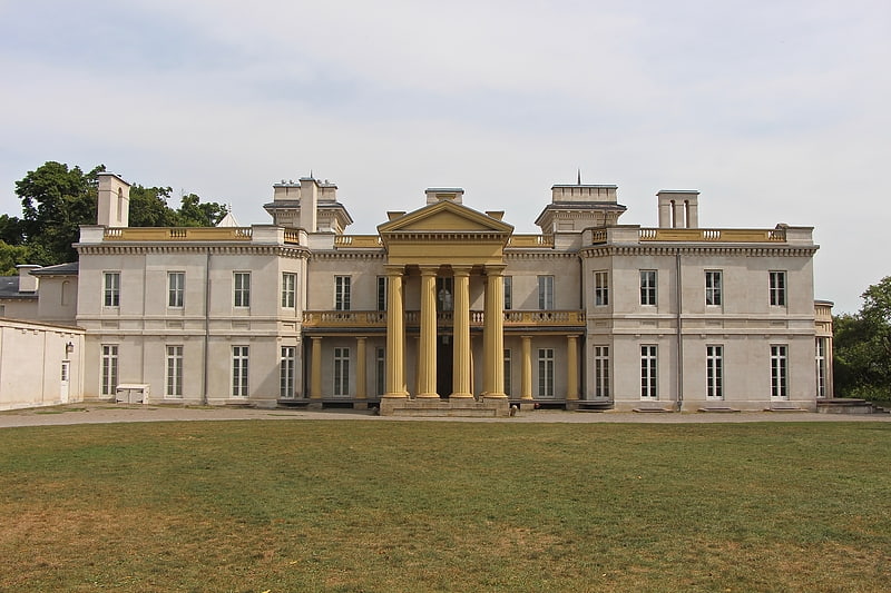
19th-century mansion. Dundurn Castle is a historic neoclassical mansion on York Boulevard in Hamilton, Ontario, Canada. The 1,700-square-metre house took three years and $175,000 to build, and was completed in 1835. The forty room castle featured the latest conveniences of gas lighting and running water. It is currently owned by the City of Hamilton, which purchased it in 1899 or 1900 for $50,000. The City has spent nearly $3 million renovating the site to make it open to the public. The rooms have been restored to the year 1855 when its owner Sir Allan Napier MacNab, 1st Baronet, was at the height of his career. Costumed interpreters guide visitors through the home, illustrating daily life from the 1850s. The Duchess of Cornwall, a descendant of Sir Allan MacNab, is the Royal Patron of Dundurn Castle.[12]
Address: 610 York Blvd, L8R 3E7 Hamilton
Chedoke Falls
Waterfall in Ontario, Canada. The city of Hamilton in Ontario, Canada is home to more than 100 waterfalls and cascades, most of which are on or near the Bruce Trail as it winds through the Niagara Escarpment. Ontario's internationally recognized Niagara Escarpment provides perfect geological conditions for waterfalls to occur, from Tobermory to Niagara Falls.
The most scenic waterfall in Hamilton is Webster's Falls. With its 30 metres (98 ft) crest, it is the largest waterfall within the city. Tew's Falls is a 41 metres (135 ft) ribbon waterfall, and is the tallest waterfall found in Hamilton. Both Webster's and Tew's are located at the Spencer Gorge / Webster's Falls Conservation Area. Albion Falls was once seriously considered as a possible source of water for Hamilton. Rocks from the Albion Falls area were used in the construction of the Royal Botanical Gardens' Rock Garden.
There used to be more waterfalls in Hamilton than exist today. Many of the waterfalls in central Hamilton slowly vanished as population and construction on Hamilton Mountain increased. As well, in the early years, James Street extended south, but was interrupted by a bog at Hunter Street which eventually (1844) was drained out and graded. Many of Hamilton's main buildings and factories in the north end are built on reclaimed or infilled land, which harmed the drainage of Hamilton and the water ecology of Hamilton Harbour.
Many of the falls in west Hamilton are accessible from the Chedoke Radial Trail. It is built on what was once the route for the Brantford and Hamilton Electric Railway owned by the Cataract Power Light and Traction Company (later Dominion Power and Transmission). The "Five Johns", (John Cameron, John Dickenson (Canadian politician), John Morison Gibson, John Moodie, Sr. and John Sutherland), formed The Cataract Power Co. Ltd. introducing electric power to Hamilton in 1898. On August 25, 1898, power was sent twenty seven miles from DeCew Falls, St. Catharines, using water from the old Welland Canal. New industries, such as the forerunners of the Steel Co. of Canada (Stelco) and Canadian Westinghouse, were attracted here by the cheaper, more efficient power. One time this Company controlled hydro power from Brantford to St. Catharines, including the Hamilton Street Railway and the area's radial lines. Back then the city's nickname was "The Electric City."
There are four waterfall types and they are designated as follows:
- Ribbon – height is notably greater than its crest width; stream forms a thin ribbon of water.
- Classical – height and crest width are nearly equal.
- Curtain – height is notably smaller than its crest width.
- Cascade – vertical drop is broken into a series of steps causing water to cascade down incline.
Some of the criteria used to define a separate Hamilton waterfall include: The waterfall has to have a vertical drop of at least 3 metres or 10 feet (3.0 m) either as a vertical drop or a cascade, the crest width has to be at least 1 metre or 3 feet (0.91 m) wide, the waterfall must have some natural component and not be entirely man-made; If a waterfall is beside another waterfall but coming from two separate creeks or streams, then they could be considered as two separate waterfalls and the waterfall has to be located within the boundaries of the new City of Hamilton.
On January 1, 2001 the new city of Hamilton was formed from the amalgamation of the Regional Municipality of Hamilton-Wentworth and its six municipalities: Hamilton, Ancaster, Dundas, Flamborough, Glanbrook, and Stoney Creek. Before amalgamation, Hamilton had a population of 331,121 divided into 100 neighbourhoods. The new amalgamated city had 490,268 people in over 200 neighbourhoods.[13]
Address: Scenic Drive & Denlow Avenue, Hamilton
Sherman Falls
Waterfall in Ontario, Canada. The city of Hamilton in Ontario, Canada is home to more than 100 waterfalls and cascades, most of which are on or near the Bruce Trail as it winds through the Niagara Escarpment. Ontario's internationally recognized Niagara Escarpment provides perfect geological conditions for waterfalls to occur, from Tobermory to Niagara Falls.
The most scenic waterfall in Hamilton is Webster's Falls. With its 30 metres (98 ft) crest, it is the largest waterfall within the city. Tew's Falls is a 41 metres (135 ft) ribbon waterfall, and is the tallest waterfall found in Hamilton. Both Webster's and Tew's are located at the Spencer Gorge / Webster's Falls Conservation Area. Albion Falls was once seriously considered as a possible source of water for Hamilton. Rocks from the Albion Falls area were used in the construction of the Royal Botanical Gardens' Rock Garden.
There used to be more waterfalls in Hamilton than exist today. Many of the waterfalls in central Hamilton slowly vanished as population and construction on Hamilton Mountain increased. As well, in the early years, James Street extended south, but was interrupted by a bog at Hunter Street which eventually (1844) was drained out and graded. Many of Hamilton's main buildings and factories in the north end are built on reclaimed or infilled land, which harmed the drainage of Hamilton and the water ecology of Hamilton Harbour.
Many of the falls in west Hamilton are accessible from the Chedoke Radial Trail. It is built on what was once the route for the Brantford and Hamilton Electric Railway owned by the Cataract Power Light and Traction Company (later Dominion Power and Transmission). The "Five Johns", (John Cameron, John Dickenson (Canadian politician), John Morison Gibson, John Moodie, Sr. and John Sutherland), formed The Cataract Power Co. Ltd. introducing electric power to Hamilton in 1898. On August 25, 1898, power was sent twenty seven miles from DeCew Falls, St. Catharines, using water from the old Welland Canal. New industries, such as the forerunners of the Steel Co. of Canada (Stelco) and Canadian Westinghouse, were attracted here by the cheaper, more efficient power. One time this Company controlled hydro power from Brantford to St. Catharines, including the Hamilton Street Railway and the area's radial lines. Back then the city's nickname was "The Electric City."
There are four waterfall types and they are designated as follows:
- Ribbon – height is notably greater than its crest width; stream forms a thin ribbon of water.
- Classical – height and crest width are nearly equal.
- Curtain – height is notably smaller than its crest width.
- Cascade – vertical drop is broken into a series of steps causing water to cascade down incline.
Some of the criteria used to define a separate Hamilton waterfall include: The waterfall has to have a vertical drop of at least 3 metres or 10 feet (3.0 m) either as a vertical drop or a cascade, the crest width has to be at least 1 metre or 3 feet (0.91 m) wide, the waterfall must have some natural component and not be entirely man-made; If a waterfall is beside another waterfall but coming from two separate creeks or streams, then they could be considered as two separate waterfalls and the waterfall has to be located within the boundaries of the new City of Hamilton.
On January 1, 2001 the new city of Hamilton was formed from the amalgamation of the Regional Municipality of Hamilton-Wentworth and its six municipalities: Hamilton, Ancaster, Dundas, Flamborough, Glanbrook, and Stoney Creek. Before amalgamation, Hamilton had a population of 331,121 divided into 100 neighbourhoods. The new amalgamated city had 490,268 people in over 200 neighbourhoods.[14]
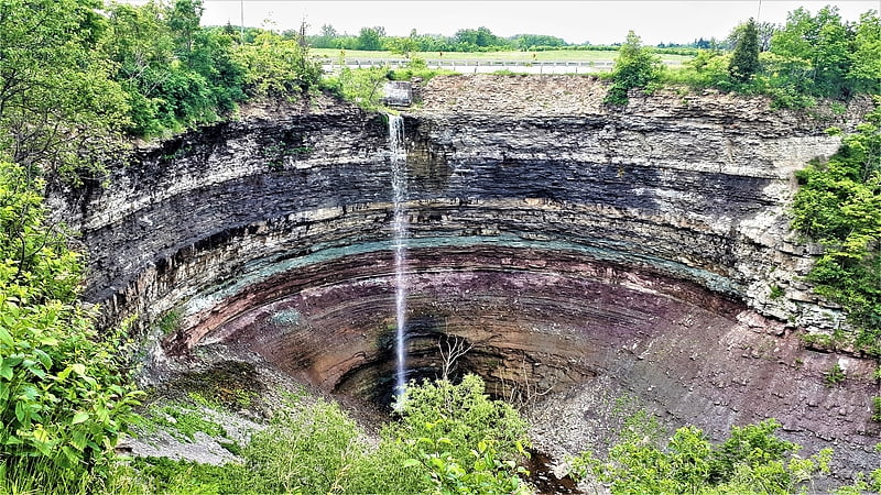
Buttermilk Falls
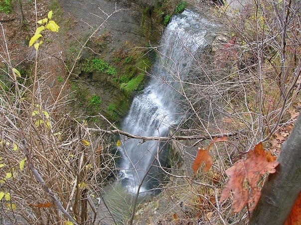
Waterfall in Ontario, Canada
Address: Mountain Brow Boulevard & Limeridge Road East, Hamilton
Great Falls
Waterfall. The city of Hamilton in Ontario, Canada is home to more than 100 waterfalls and cascades, most of which are on or near the Bruce Trail as it winds through the Niagara Escarpment. Ontario's internationally recognized Niagara Escarpment provides perfect geological conditions for waterfalls to occur, from Tobermory to Niagara Falls.
The most scenic waterfall in Hamilton is Webster's Falls. With its 30 metres (98 ft) crest, it is the largest waterfall within the city. Tew's Falls is a 41 metres (135 ft) ribbon waterfall, and is the tallest waterfall found in Hamilton. Both Webster's and Tew's are located at the Spencer Gorge / Webster's Falls Conservation Area. Albion Falls was once seriously considered as a possible source of water for Hamilton. Rocks from the Albion Falls area were used in the construction of the Royal Botanical Gardens' Rock Garden.
There used to be more waterfalls in Hamilton than exist today. Many of the waterfalls in central Hamilton slowly vanished as population and construction on Hamilton Mountain increased. As well, in the early years, James Street extended south, but was interrupted by a bog at Hunter Street which eventually (1844) was drained out and graded. Many of Hamilton's main buildings and factories in the north end are built on reclaimed or infilled land, which harmed the drainage of Hamilton and the water ecology of Hamilton Harbour.
Many of the falls in west Hamilton are accessible from the Chedoke Radial Trail. It is built on what was once the route for the Brantford and Hamilton Electric Railway owned by the Cataract Power Light and Traction Company (later Dominion Power and Transmission). The "Five Johns", (John Cameron, John Dickenson (Canadian politician), John Morison Gibson, John Moodie, Sr. and John Sutherland), formed The Cataract Power Co. Ltd. introducing electric power to Hamilton in 1898. On August 25, 1898, power was sent twenty seven miles from DeCew Falls, St. Catharines, using water from the old Welland Canal. New industries, such as the forerunners of the Steel Co. of Canada (Stelco) and Canadian Westinghouse, were attracted here by the cheaper, more efficient power. One time this Company controlled hydro power from Brantford to St. Catharines, including the Hamilton Street Railway and the area's radial lines. Back then the city's nickname was "The Electric City."
There are four waterfall types and they are designated as follows:
- Ribbon – height is notably greater than its crest width; stream forms a thin ribbon of water.
- Classical – height and crest width are nearly equal.
- Curtain – height is notably smaller than its crest width.
- Cascade – vertical drop is broken into a series of steps causing water to cascade down incline.
Some of the criteria used to define a separate Hamilton waterfall include: The waterfall has to have a vertical drop of at least 3 metres or 10 feet (3.0 m) either as a vertical drop or a cascade, the crest width has to be at least 1 metre or 3 feet (0.91 m) wide, the waterfall must have some natural component and not be entirely man-made; If a waterfall is beside another waterfall but coming from two separate creeks or streams, then they could be considered as two separate waterfalls and the waterfall has to be located within the boundaries of the new City of Hamilton.
On January 1, 2001 the new city of Hamilton was formed from the amalgamation of the Regional Municipality of Hamilton-Wentworth and its six municipalities: Hamilton, Ancaster, Dundas, Flamborough, Glanbrook, and Stoney Creek. Before amalgamation, Hamilton had a population of 331,121 divided into 100 neighbourhoods. The new amalgamated city had 490,268 people in over 200 neighbourhoods.[15]
Address: Mill Street South, L7R 3X5 Waterdown
Borer's Falls
Waterfall in Ontario, Canada. Borer's Falls is a 15-metre-high ribbon-style waterfall found in the Borer's Falls Conservation Area in Dundas, Hamilton, Ontario, Canada. Its source is Borer's Creek. A very picturesque waterfall featured on many Hamilton waterfall postcards over the years. Named after the Borer family who ran a sawmill for over a century. This mill was the lifeblood of the village of Rock Chapel. Also known as Rock Chapel Falls. The area is a hiker's haven and also an ice-climbing destination in the winter when the weather is cold enough to freeze the Falls.
Nearby attractions include the Bruce Trail, Cootes Paradise, Borer's Falls, Borer's Falls Conservation Area, the Spencer Gorge / Webster's Falls Conservation Area, Rock Chapel Sanctuary and Royal Botanical Gardens, who own the lands around the falls. There are also many other waterfalls in the area.
Lower Borer's Falls is a complex curtain/ cascade waterfall, 3 metres in height and 5 metres wide and a 10-minute walking distance south of Borer's Falls. Difficult to access. Good pair of hiking boots recommended to access by foot.[16]
Address: Rock Chapel Rd., Dundas, Hamilton (Rural Flamborough)
Hamilton Farmer's Market
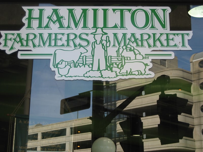
The Hamilton Farmers' Market was founded in 1837 is located within a large multi-faceted complex in downtown Hamilton, Ontario called Lloyd D. Jackson Square on the corner of James Street & York Boulevard. It is an indoor market known well by locals for its variety of foods and products, produced both locally and from around the world. In 2007 a proposal of $5.1-million for renovation was made.[17]
Address: 55 York Blvd, L8R 3K1 Hamilton (Downtown Hamilton)
Sisters of Mary Falls

The city of Hamilton in Ontario, Canada is home to more than 100 waterfalls and cascades, most of which are on or near the Bruce Trail as it winds through the Niagara Escarpment. Ontario's internationally recognized Niagara Escarpment provides perfect geological conditions for waterfalls to occur, from Tobermory to Niagara Falls.
The most scenic waterfall in Hamilton is Webster's Falls. With its 30 metres (98 ft) crest, it is the largest waterfall within the city. Tew's Falls is a 41 metres (135 ft) ribbon waterfall, and is the tallest waterfall found in Hamilton. Both Webster's and Tew's are located at the Spencer Gorge / Webster's Falls Conservation Area. Albion Falls was once seriously considered as a possible source of water for Hamilton. Rocks from the Albion Falls area were used in the construction of the Royal Botanical Gardens' Rock Garden.
There used to be more waterfalls in Hamilton than exist today. Many of the waterfalls in central Hamilton slowly vanished as population and construction on Hamilton Mountain increased. As well, in the early years, James Street extended south, but was interrupted by a bog at Hunter Street which eventually (1844) was drained out and graded. Many of Hamilton's main buildings and factories in the north end are built on reclaimed or infilled land, which harmed the drainage of Hamilton and the water ecology of Hamilton Harbour.
Many of the falls in west Hamilton are accessible from the Chedoke Radial Trail. It is built on what was once the route for the Brantford and Hamilton Electric Railway owned by the Cataract Power Light and Traction Company (later Dominion Power and Transmission). The "Five Johns", (John Cameron, John Dickenson (Canadian politician), John Morison Gibson, John Moodie, Sr. and John Sutherland), formed The Cataract Power Co. Ltd. introducing electric power to Hamilton in 1898. On August 25, 1898, power was sent twenty seven miles from DeCew Falls, St. Catharines, using water from the old Welland Canal. New industries, such as the forerunners of the Steel Co. of Canada (Stelco) and Canadian Westinghouse, were attracted here by the cheaper, more efficient power. One time this Company controlled hydro power from Brantford to St. Catharines, including the Hamilton Street Railway and the area's radial lines. Back then the city's nickname was "The Electric City."
There are four waterfall types and they are designated as follows:
- Ribbon – height is notably greater than its crest width; stream forms a thin ribbon of water.
- Classical – height and crest width are nearly equal.
- Curtain – height is notably smaller than its crest width.
- Cascade – vertical drop is broken into a series of steps causing water to cascade down incline.
Some of the criteria used to define a separate Hamilton waterfall include: The waterfall has to have a vertical drop of at least 3 metres or 10 feet (3.0 m) either as a vertical drop or a cascade, the crest width has to be at least 1 metre or 3 feet (0.91 m) wide, the waterfall must have some natural component and not be entirely man-made; If a waterfall is beside another waterfall but coming from two separate creeks or streams, then they could be considered as two separate waterfalls and the waterfall has to be located within the boundaries of the new City of Hamilton.
On January 1, 2001 the new city of Hamilton was formed from the amalgamation of the Regional Municipality of Hamilton-Wentworth and its six municipalities: Hamilton, Ancaster, Dundas, Flamborough, Glanbrook, and Stoney Creek. Before amalgamation, Hamilton had a population of 331,121 divided into 100 neighbourhoods. The new amalgamated city had 490,268 people in over 200 neighbourhoods.[18]
Bayfront Park
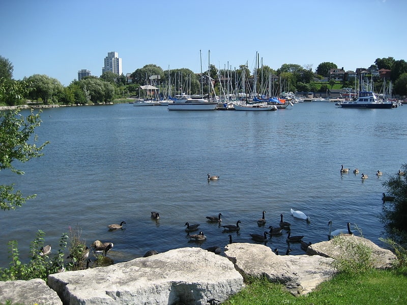
Park in Hamilton, Ontario. Bayfront Park is a 16-hectare park found in the West-end of Hamilton Harbour in the North End neighbourhood of Hamilton, Ontario, Canada.
Over $9 million transformed formerly vacant land into a versatile green space, with 1,800 metres (5,906 ft) of shoreline integrating fish habitat, native vegetation and facilities. The park is the site of a variety of summer festivals and concerts. A protected sandy beach and a 6-metre (20 ft) wide trail circles the park.
Other important features of the park include: a public boat launch, fishing opportunities, a 250 space parking lot, and pedestrian and bicycle trails leading to Pier 4 Park.
Nearby attractions include the Harbour West Marina Complex, Macassa Bay Yacht Club, Pier 4 Park, Pier 8, HHC Sailing School and the Royal Hamilton Yacht Club.[19]
Address: 200 Harbour Front Drive, L8L 1C8 Hamilton
Art Gallery of Hamilton
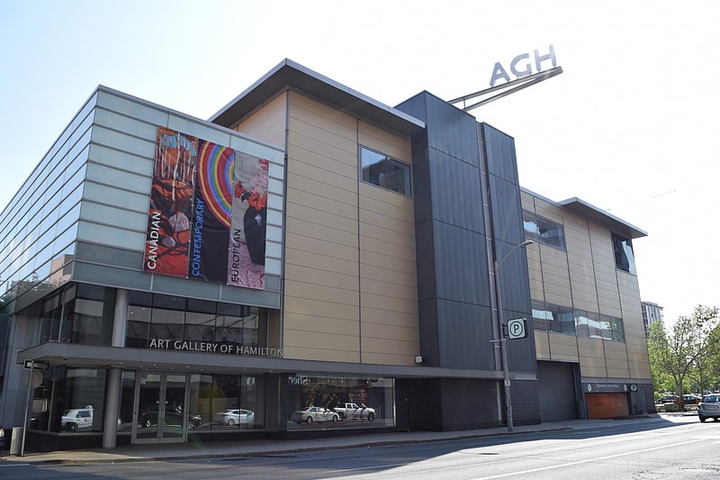
Museum in Hamilton, Ontario. The Art Gallery of Hamilton is an art museum located in Hamilton, Ontario, Canada. The museum occupies a 7,000 square metres building on King Street West in downtown Hamilton, designed by Trevor P. Garwood-Jones. The institution is southwestern Ontario's largest and oldest art museum.
The museum was established as the Municipal Gallery of Hamilton in January 1914, and was opened to the public in June 1914, at a Hamilton Public Library building on Main Street West. The museum continued to operate from that location until 1953, when the museum relocated to a new building in the neighbourhood of Westdale. In 1977, the museum moved to its present King Street West location. The museum building was renovated with designs by Bruce Kuwabara from 2003 to 2005.
The Art Gallery of Hamilton's permanent collection has over 10,000 works by artists from Canada, and around the world. In addition to exhibiting works from its collection, the museum has also organized, and hosted a number of travelling exhibitions.[20]
Address: 123 King St W, L8P 4S8 Hamilton (Downtown Hamilton)
Pier 4 Park
Park in Hamilton, Ontario. Pier 4 Park is a 2.4 hectare park found in the west-end of Hamilton Harbour near Bay Street North in Hamilton, Ontario, Canada.
The park features a multi-use asphalt trail, 349 metres in length and 4 metres wide which provides barrier-free access to all areas of the park and linkages with the surrounding harbourfront precinct. A total of $2.2 million has been invested for the redevelopment of the park which includes a 24-metre tugboat which acts as the centrepiece of an interactive water play area for children. A dramatically curved lookout pier includes a protected sun shelter and benches to view the marinas, parkland and vistas of the surrounding Bay.
In addition Hamilton Harbour Commissioners (HHC) have constructed Hamilton Pier which provides 0.4 hectares of additional parkland and fish habitat.
Nearby attractions include the Harbour West Marina Complex, Macassa Bay Yacht Club, Pier 8, Bayfront Park, HHC Sailing School and the Royal Hamilton Yacht Club.[21]
Address: Leander Dr., L8L 1N2 Hamilton
Gore Park
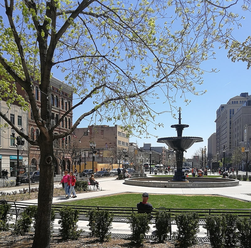
Park in Hamilton, Ontario. Gore Park is a town square or urban park located in downtown Hamilton, Ontario.[22]
Address: 1 Hughson Street South, Hamilton (Downtown Hamilton)
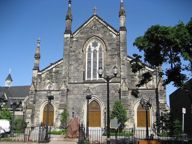
Cathedral Basilica of Christ the King
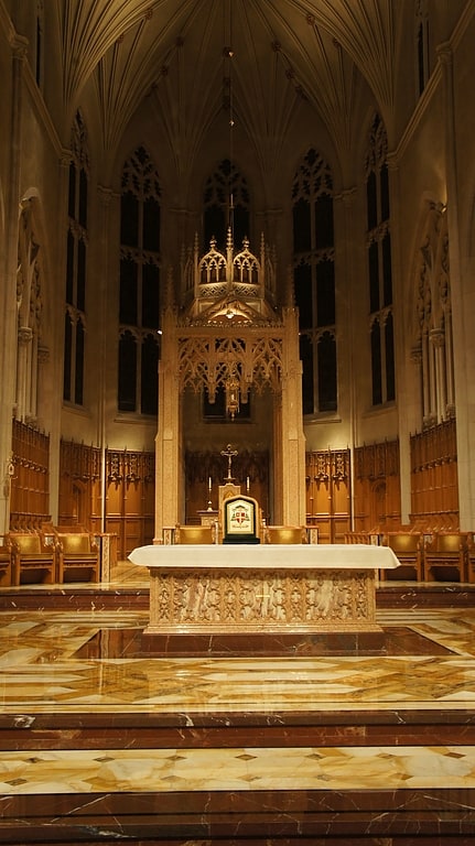
Catholic cathedral in Hamilton, Ontario. The Cathedral Basilica of Christ the King is a Roman Catholic church in Hamilton, Ontario, Canada. The cathedral was consecrated on December 19, 1933. It is the seat of the Bishop of the Diocese of Hamilton, and the cathedral of the Diocese of Hamilton. The cathedral contains the cathedra of the Bishop, the Most Rev. Douglas Crosby. The cathedral was raised to the status of a minor basilica in February 2013 by Pope Benedict XVI.
On the south side of the bell tower is the cornerstone blessed by Bishop McNally, builder of the cathedral and fifth bishop of the diocese. It is a stone excavated from the Roman Catacombs to symbolize the cathedral's unity with the ancient Christian church, the first generation after Christ. The cathedral is perched atop a hill overlooking Highway 403 leading in towards the rest of Hamilton and one travelling towards Oakville, Mississauga and Toronto. Christ the King Cathedral is close in proximity to the Hamilton-Wentworth Catholic District School Board administration offices, and the offices for the Diocese of Hamilton. The offices for the diocese are located just off to the side of the cathedral, next to the rectory.[23]
Address: 714 King St W, L8P 1C7 Hamilton
Tim Hortons Field
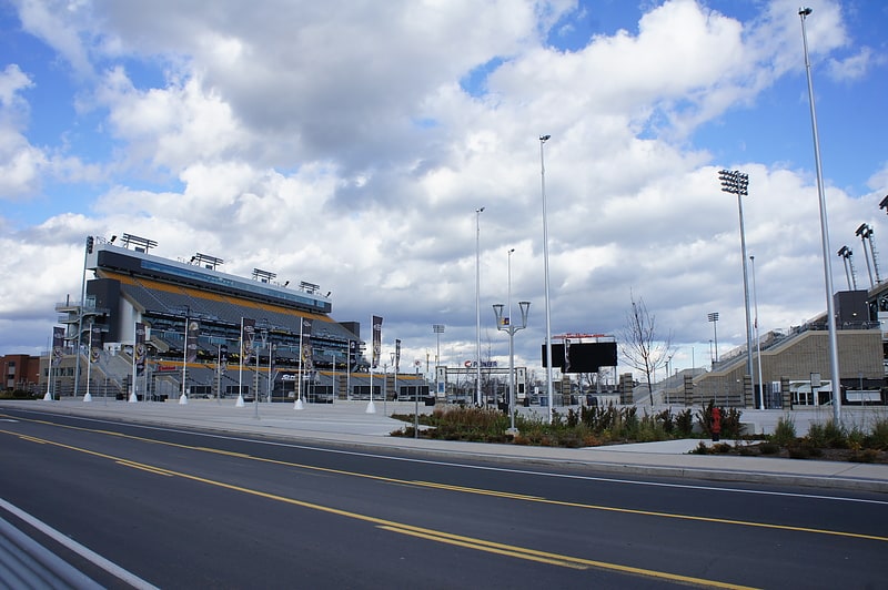
Multi-purpose stadium in Hamilton, Ontario. Tim Hortons Field, nicknamed "The Donut Box", is a multi-purpose stadium in Hamilton, Ontario, Canada. Built as a replacement for Ivor Wynne Stadium, Tim Hortons Field is primarily used for Canadian football and soccer, and is the home of the Hamilton Tiger-Cats of the Canadian Football League and Forge FC of the Canadian Premier League. During the 2015 Pan American Games, it was referred to as CIBC Hamilton Pan Am Soccer Stadium. The stadium opened in September 2014, two months after its original anticipated completion date of June 30, 2014.[24]
Address: Hamilton, 64 Melrose Avenue North
Felker's Falls
Waterfall in Ontario, Canada. The city of Hamilton in Ontario, Canada is home to more than 100 waterfalls and cascades, most of which are on or near the Bruce Trail as it winds through the Niagara Escarpment. Ontario's internationally recognized Niagara Escarpment provides perfect geological conditions for waterfalls to occur, from Tobermory to Niagara Falls.
The most scenic waterfall in Hamilton is Webster's Falls. With its 30 metres (98 ft) crest, it is the largest waterfall within the city. Tew's Falls is a 41 metres (135 ft) ribbon waterfall, and is the tallest waterfall found in Hamilton. Both Webster's and Tew's are located at the Spencer Gorge / Webster's Falls Conservation Area. Albion Falls was once seriously considered as a possible source of water for Hamilton. Rocks from the Albion Falls area were used in the construction of the Royal Botanical Gardens' Rock Garden.
There used to be more waterfalls in Hamilton than exist today. Many of the waterfalls in central Hamilton slowly vanished as population and construction on Hamilton Mountain increased. As well, in the early years, James Street extended south, but was interrupted by a bog at Hunter Street which eventually (1844) was drained out and graded. Many of Hamilton's main buildings and factories in the north end are built on reclaimed or infilled land, which harmed the drainage of Hamilton and the water ecology of Hamilton Harbour.
Many of the falls in west Hamilton are accessible from the Chedoke Radial Trail. It is built on what was once the route for the Brantford and Hamilton Electric Railway owned by the Cataract Power Light and Traction Company (later Dominion Power and Transmission). The "Five Johns", (John Cameron, John Dickenson (Canadian politician), John Morison Gibson, John Moodie, Sr. and John Sutherland), formed The Cataract Power Co. Ltd. introducing electric power to Hamilton in 1898. On August 25, 1898, power was sent twenty seven miles from DeCew Falls, St. Catharines, using water from the old Welland Canal. New industries, such as the forerunners of the Steel Co. of Canada (Stelco) and Canadian Westinghouse, were attracted here by the cheaper, more efficient power. One time this Company controlled hydro power from Brantford to St. Catharines, including the Hamilton Street Railway and the area's radial lines. Back then the city's nickname was "The Electric City."
There are four waterfall types and they are designated as follows:
- Ribbon – height is notably greater than its crest width; stream forms a thin ribbon of water.
- Classical – height and crest width are nearly equal.
- Curtain – height is notably smaller than its crest width.
- Cascade – vertical drop is broken into a series of steps causing water to cascade down incline.
Some of the criteria used to define a separate Hamilton waterfall include: The waterfall has to have a vertical drop of at least 3 metres or 10 feet (3.0 m) either as a vertical drop or a cascade, the crest width has to be at least 1 metre or 3 feet (0.91 m) wide, the waterfall must have some natural component and not be entirely man-made; If a waterfall is beside another waterfall but coming from two separate creeks or streams, then they could be considered as two separate waterfalls and the waterfall has to be located within the boundaries of the new City of Hamilton.
On January 1, 2001 the new city of Hamilton was formed from the amalgamation of the Regional Municipality of Hamilton-Wentworth and its six municipalities: Hamilton, Ancaster, Dundas, Flamborough, Glanbrook, and Stoney Creek. Before amalgamation, Hamilton had a population of 331,121 divided into 100 neighbourhoods. The new amalgamated city had 490,268 people in over 200 neighbourhoods.[25]
Address: Ackland Street, L8J 1R3 Stoney Creek (Stoney Creek Mountain)
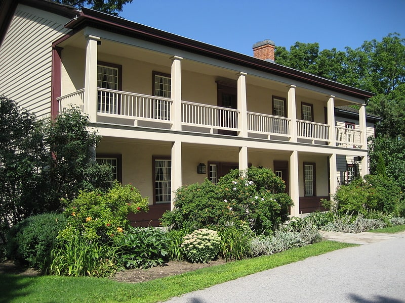
Erland Lee Museum
Museum in Hamilton, Ontario. The Erland Lee Museum is a National Historic Site of Canada located on the ridge of the Niagara Escarpment in Stoney Creek, Hamilton, Ontario. Originally a farmhouse belonging to Erland and Janet Lee, the museum is recognized as the birthplace of the first Women's Institute, an international organization formed in 1897 to promote the education of isolated rural women.
The oldest part of the home, a log cabin, dates to 1808. An addition was built onto the log cabin in 1873 in the Carpenter Gothic style, part of the Gothic Revival Architectural tradition. This is best exemplified by the steeply-pitched gables, gingerbread trim, and the board-and-batten planks.
The Lee Family lived in the house from 1808 until 1970. Its first historical designation was granted in 1961, by the South Wentworth Women’s Institute. In 1972, the home was opened to the public as a museum, and has since been owned and operated by the Federated Women's Institutes of Ontario. In 1995, the museum was designated as a historic home under the Ontario Heritage Act, and in 2003, the museum was granted status as a National Historic Site of Canada.
The museum closed in December 2010, but reopened 21 April 2013.
The museum itself contains three floors of original Victorian furniture and furnishings, with an emphasis on the history of the Lee family, and the events surrounding the 1897 founding of the Women's Institutes. For example, the dining room table on which Janet Lee wrote the first Women’s Institute constitution still stands in its original location. The farmhouse is complemented by an 1873 carriage house, which contains two floors of local history exhibits.[26]
Address: 552 Ridge Rd, L8J 2Y6 Stoney Creek (Rural Stoney Creek)
Whitehern
Museum in Hamilton, Ontario. Whitehern Historic House and Garden in Hamilton, Ontario, Canada, built shortly before 1850, is a Late Classical house that is now a historic house museum.
At one time, Whitehern was the home of the McQuesten family, including Mary Baker McQuesten and Thomas McQuesten. His historic downtown family home was willed to the City of Hamilton, after the death of the last of his five unmarried siblings in 1968. It is situated on the corner of Jackson Street West and MacNab Street South, just east of the Hamilton City Hall and behind the Canadian Football Hall of Fame museum. After its restoration was complete in 1971, Whitehern has been open as a civic museum and has occasionally served as a period film location. It was designated a National Historic Site of Canada in 1962. An Ontario Historical Plaque was erected by the province to commemorate Whitehern's role in Ontario's heritage.
Among the many Hamilton civic leaders and boosters, McQuesten helped encourage McMaster University to relocate from downtown Toronto to west Hamilton in 1930, and was instrumental in the creation of the Royal Botanical Gardens.[27]
Address: 41 Jackson St W, L8P 1L3 Hamilton (Downtown Hamilton)
Lower Little Falls
The city of Hamilton in Ontario, Canada is home to more than 100 waterfalls and cascades, most of which are on or near the Bruce Trail as it winds through the Niagara Escarpment. Ontario's internationally recognized Niagara Escarpment provides perfect geological conditions for waterfalls to occur, from Tobermory to Niagara Falls.
The most scenic waterfall in Hamilton is Webster's Falls. With its 30 metres (98 ft) crest, it is the largest waterfall within the city. Tew's Falls is a 41 metres (135 ft) ribbon waterfall, and is the tallest waterfall found in Hamilton. Both Webster's and Tew's are located at the Spencer Gorge / Webster's Falls Conservation Area. Albion Falls was once seriously considered as a possible source of water for Hamilton. Rocks from the Albion Falls area were used in the construction of the Royal Botanical Gardens' Rock Garden.
There used to be more waterfalls in Hamilton than exist today. Many of the waterfalls in central Hamilton slowly vanished as population and construction on Hamilton Mountain increased. As well, in the early years, James Street extended south, but was interrupted by a bog at Hunter Street which eventually (1844) was drained out and graded. Many of Hamilton's main buildings and factories in the north end are built on reclaimed or infilled land, which harmed the drainage of Hamilton and the water ecology of Hamilton Harbour.
Many of the falls in west Hamilton are accessible from the Chedoke Radial Trail. It is built on what was once the route for the Brantford and Hamilton Electric Railway owned by the Cataract Power Light and Traction Company (later Dominion Power and Transmission). The "Five Johns", (John Cameron, John Dickenson (Canadian politician), John Morison Gibson, John Moodie, Sr. and John Sutherland), formed The Cataract Power Co. Ltd. introducing electric power to Hamilton in 1898. On August 25, 1898, power was sent twenty seven miles from DeCew Falls, St. Catharines, using water from the old Welland Canal. New industries, such as the forerunners of the Steel Co. of Canada (Stelco) and Canadian Westinghouse, were attracted here by the cheaper, more efficient power. One time this Company controlled hydro power from Brantford to St. Catharines, including the Hamilton Street Railway and the area's radial lines. Back then the city's nickname was "The Electric City."
There are four waterfall types and they are designated as follows:
- Ribbon – height is notably greater than its crest width; stream forms a thin ribbon of water.
- Classical – height and crest width are nearly equal.
- Curtain – height is notably smaller than its crest width.
- Cascade – vertical drop is broken into a series of steps causing water to cascade down incline.
Some of the criteria used to define a separate Hamilton waterfall include: The waterfall has to have a vertical drop of at least 3 metres or 10 feet (3.0 m) either as a vertical drop or a cascade, the crest width has to be at least 1 metre or 3 feet (0.91 m) wide, the waterfall must have some natural component and not be entirely man-made; If a waterfall is beside another waterfall but coming from two separate creeks or streams, then they could be considered as two separate waterfalls and the waterfall has to be located within the boundaries of the new City of Hamilton.
On January 1, 2001 the new city of Hamilton was formed from the amalgamation of the Regional Municipality of Hamilton-Wentworth and its six municipalities: Hamilton, Ancaster, Dundas, Flamborough, Glanbrook, and Stoney Creek. Before amalgamation, Hamilton had a population of 331,121 divided into 100 neighbourhoods. The new amalgamated city had 490,268 people in over 200 neighbourhoods.[28]
Stephanie Falls

The city of Hamilton in Ontario, Canada is home to more than 100 waterfalls and cascades, most of which are on or near the Bruce Trail as it winds through the Niagara Escarpment. Ontario's internationally recognized Niagara Escarpment provides perfect geological conditions for waterfalls to occur, from Tobermory to Niagara Falls.
The most scenic waterfall in Hamilton is Webster's Falls. With its 30 metres (98 ft) crest, it is the largest waterfall within the city. Tew's Falls is a 41 metres (135 ft) ribbon waterfall, and is the tallest waterfall found in Hamilton. Both Webster's and Tew's are located at the Spencer Gorge / Webster's Falls Conservation Area. Albion Falls was once seriously considered as a possible source of water for Hamilton. Rocks from the Albion Falls area were used in the construction of the Royal Botanical Gardens' Rock Garden.
There used to be more waterfalls in Hamilton than exist today. Many of the waterfalls in central Hamilton slowly vanished as population and construction on Hamilton Mountain increased. As well, in the early years, James Street extended south, but was interrupted by a bog at Hunter Street which eventually (1844) was drained out and graded. Many of Hamilton's main buildings and factories in the north end are built on reclaimed or infilled land, which harmed the drainage of Hamilton and the water ecology of Hamilton Harbour.
Many of the falls in west Hamilton are accessible from the Chedoke Radial Trail. It is built on what was once the route for the Brantford and Hamilton Electric Railway owned by the Cataract Power Light and Traction Company (later Dominion Power and Transmission). The "Five Johns", (John Cameron, John Dickenson (Canadian politician), John Morison Gibson, John Moodie, Sr. and John Sutherland), formed The Cataract Power Co. Ltd. introducing electric power to Hamilton in 1898. On August 25, 1898, power was sent twenty seven miles from DeCew Falls, St. Catharines, using water from the old Welland Canal. New industries, such as the forerunners of the Steel Co. of Canada (Stelco) and Canadian Westinghouse, were attracted here by the cheaper, more efficient power. One time this Company controlled hydro power from Brantford to St. Catharines, including the Hamilton Street Railway and the area's radial lines. Back then the city's nickname was "The Electric City."
There are four waterfall types and they are designated as follows:
- Ribbon – height is notably greater than its crest width; stream forms a thin ribbon of water.
- Classical – height and crest width are nearly equal.
- Curtain – height is notably smaller than its crest width.
- Cascade – vertical drop is broken into a series of steps causing water to cascade down incline.
Some of the criteria used to define a separate Hamilton waterfall include: The waterfall has to have a vertical drop of at least 3 metres or 10 feet (3.0 m) either as a vertical drop or a cascade, the crest width has to be at least 1 metre or 3 feet (0.91 m) wide, the waterfall must have some natural component and not be entirely man-made; If a waterfall is beside another waterfall but coming from two separate creeks or streams, then they could be considered as two separate waterfalls and the waterfall has to be located within the boundaries of the new City of Hamilton.
On January 1, 2001 the new city of Hamilton was formed from the amalgamation of the Regional Municipality of Hamilton-Wentworth and its six municipalities: Hamilton, Ancaster, Dundas, Flamborough, Glanbrook, and Stoney Creek. Before amalgamation, Hamilton had a population of 331,121 divided into 100 neighbourhoods. The new amalgamated city had 490,268 people in over 200 neighbourhoods.[29]
Hamilton Cemetery
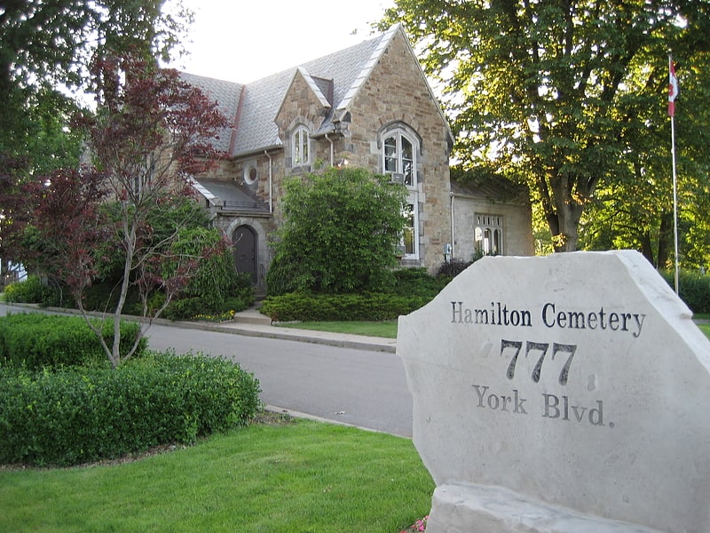
Burial ground. Hamilton Cemetery on York Boulevard in Hamilton, Ontario is the oldest, public burial ground in the city of Hamilton. It is located on Burlington Heights, a high sand- and gravel isthmus that separates Hamilton's harbor on the east from Cootes Paradise on the west.
Historically, the cemetery consists of three, separate burial grounds over 100 acres: Burlington Heights Cemetery, the Christ Church Grounds, and the Church of Ascension Grounds. It has been a contentious issue whether a flood, around the 1860s inundated the city, necessitating the re-collecting of gravestones to be amassed in one place. From 1850 until 1892, each burial ground was administered separately, but by the beginning of the 1890s, the church wardens were encountering difficulty paying for the maintenance-and upkeep of their areas of the grounds. In 1892, an agreement with the City of Hamilton who assumed responsibility for all the grounds, which were renamed "Hamilton Cemetery".[30]
Address: 777 York Blvd, L8R 2A4 Hamilton
HMCS Haida
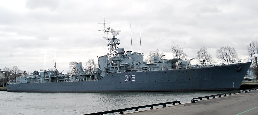
Docked naval destroyer with guided tours. HMCS Haida is a Tribal-class destroyer that served in the Royal Canadian Navy from 1943 to 1963, participating in World War II and the Korean War. She was named for the Haida people.
The only surviving Tribal-class destroyer out of 27 vessels constructed for the RCN, the Royal Navy, and the Royal Australian Navy between 1937 and 1945, Haida sank more enemy surface tonnage than any other Canadian warship and as such is commonly referred to as the "Fightingest Ship in the Royal Canadian Navy".
Designated a National Historic Site of Canada in 1984, she now serves as a museum ship berthed next to HMCS Star, an active Royal Canadian Naval Reserve Division, in Hamilton, Ontario. In 2018, Haida was designated the ceremonial flagship of the RCN.[31]
Address: 658 Catharine St N, L8L 8K4 Hamilton
Eramosa Karst
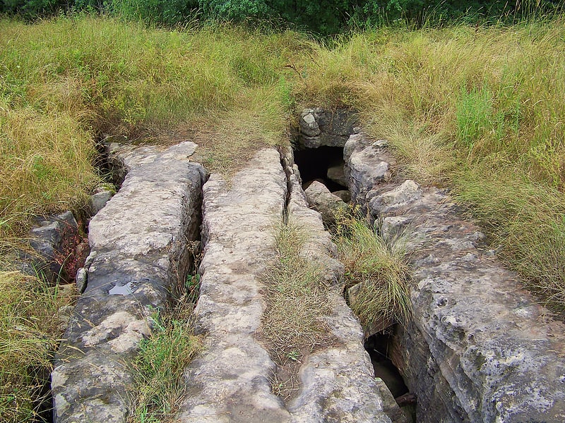
Hiking area in Hamilton, Ontario. The Eramosa Karst is a provincially significant Earth Science Area of Natural and Scientific Interest in Ontario, Canada, located in Stoney Creek, a constituent community of the City of Hamilton, and immediately south of the Niagara Escarpment.
It exhibits sixteen different karstic geological features, of which seven are provincially significant, and is considered to be the best example of karst topography found in Ontario. The area is composed of parcels of land that are provincially, municipally and privately owned. It received ANSI-ES designation on February 13, 2003.[32]
Darnley Cascade
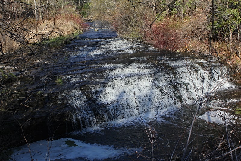
Cascade in Ontario, Canada. Darnley Cascade is a 4-metre-high cascade waterfall located at Crooks Hollow Conservation Area in Greensville, Hamilton, Ontario, Canada. Nearby attractions include Bruce Trail, Dundas Valley Conservation Area, Spencer Gorge/Webster's Falls Conservation Area, Hermitage ruins, Royal Botanical Gardens, Dundurn Castle, Christie Lake Conservation Area, Dundas Historical Society Museum and Carnegie Gallery.
The waterfall got its name from the Darnley Grist Mill, completed in 1813 by Scottish settler James Crooks, who admired Lord Darnley and claimed him as an ancestor. The grist mill was sold to James Stutt after Crooks' death in 1860. Darnley Cascade is sometimes referred to as Stutt's Falls, a name which is used on vintage postcards of the area. The mill burned down in 1934, but the ruins remain.
An article published in November 2020 states that the Darnley mill was expanded in 1829 to include "a distillery, a linseed oil mill, a cooperage, a card clothing factory, a fulling and drying works, a tannery, a woollen mill, a foundry, an agricultural implement factory and Upper Canada’s first paper mill". The community also grew in that era, with a general store and inn; residents lived along the valley road. Today, the site "is considered to be one of Ontario’s oldest ruins and is just one of the remains of the early industrial empire of James Crooks and of the community which became Crooks Hollow".
Another nearby mill which was destroyed by fire in 1875, also built by James Crooks, is considered to have been "Upper Canada's First Paper Mill (1826)".[33]
Christ's Church Cathedral
Cathedral in Hamilton, Ontario. Christ's Church Cathedral is a cathedral of the Anglican Diocese of Niagara, located at 252 James Street North, in Hamilton, Ontario, Canada. The parish was established in 1835, with construction for the present building taking place from 1852 to 1873. The cathedral has gone through several expansions and renovations since its opening in 1876.[34]
Address: 252 James St N, L8R 2L3 Hamilton (Downtown Hamilton)