Discover 11 hidden attractions, cool sights, and unusual things to do in Nanaimo (Canada). Don't miss out on these must-see attractions: Nanaimo Bastion, Saysutshun Park, and Christian Science Society. Also, be sure to include Vancouver Island Conference Centre in your itinerary.
Below, you can find the list of the most amazing places you should visit in Nanaimo (British Columbia).
Table of Contents
Nanaimo Bastion
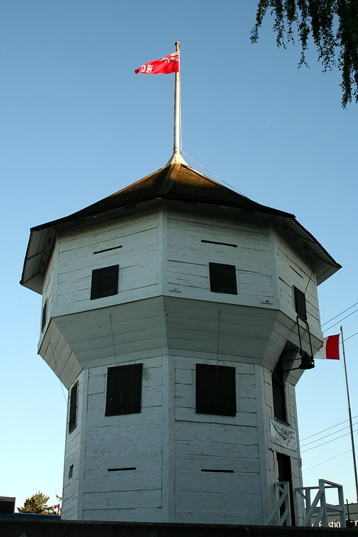
Fortification in Nanaimo, British Columbia. The Nanaimo Bastion is a historical octagon-shaped blockhouse located at 98 Front Street in Nanaimo, British Columbia, Canada. The Hudson's Bay Company, which then held a royal lease on all of what was then the Colony of Vancouver Island, built it between 1853 and 1855 to defend its coal mining operations in Nanaimo. It has been called "Nanaimo's premier landmark", because of its shape and its high visibility from both land and sea.
The Bastion was constructed using the pièce-sur-pièce (post-and-plank) method. This entailed laying timbers across each other horizontally, with tenons cut into the ends. These tenons would then be inserted into vertical posts. This method was used partially due to the expensive cost of nails; by using the pièce-sur-pièce method, very few nails were needed. The logs were squared using only basic hand tools: a crosscut saw, broadaxe, adze, auger and pit saw. The wooden structure sat on a masonry foundation and was three stories tall. It is the only remaining freestanding tower structure built by the Hudson's Bay Company.
In 1891, the Bastion faced demolition threats. The city, recognising the historic value of the building, paid a sum of $175 for the building and moved it across the street from its original location (this would be the parking lot of the modern day Dorchester Hotel). It was moved a second time in 1979, when the roads were being widened. On December 12, 1985, the city of Nanaimo designated it a local heritage site. During the summer of 2010, the Bastion was torn apart to renew rotting boards and add stabilizing steel beams. The director of the event said that they were "making a historic movement".
The Bastion is managed by the Nanaimo Museum and is open to visitors during the summer (May Long to Labour Day) from 9:00 am to 5:00 pm (hours subject to change). It functions as a tourist information center on behalf of Tourism Nanaimo, and holds exhibits on the history of the building. The Nanaimo Museum also hosts a daily cannon firing at noon during the summer months, just a few feet away from the Bastion.
The Bastion is the main image on HMCS Nanaimo's ships crest. HMCS Nanaimo is a Kingston-class Coastal Defence vessel that has been serving in the Royal Canadian Navy since 1997.[1]
Address: 98 Front Street, V9R 5H7 Nanaimo
Saysutshun Park
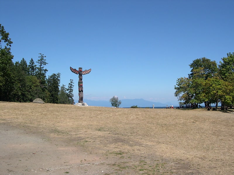
Island. Saysutshun Park, formally known as Newcastle Island Marine Provincial Park, is a provincial park located on a small island off the coast of Nanaimo, British Columbia, Canada.[2]
Christian Science Society
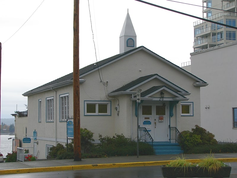
Building in Nanaimo, British Columbia. Christian Science Society, also called the Christian Science Society Building, is an historic single storey style Christian Science church edifice located at 20 Chapel Street in Nanaimo, British Columbia, Canada. It was built between 1900 and 1910 as a single-family house and was known as the McDonald Property. In 1932 it was converted to church use by being placed on a concrete foundation and having its exterior stuccoed while the interior was gutted and remodeled for its new use. Citing the building as a "good example of early adaptive re-use" and '"very good example of Classical Period Revival architecture", albeit "a very modest rendition of the style", the city designated it a local heritage site on October 7, 2002.
Christian Science Society is still an active congregation listed in the Christian Science Journal.[3]
Vancouver Island Conference Centre
Public library system. The Vancouver Island Regional Library is the fourth-largest library system in British Columbia. It serves more than 430,000 people on Vancouver Island, Haida Gwaii and the Central Coast through 39 branch libraries and a books-by-mail service. Administrative offices are located in Nanaimo. Vancouver Island Regional Library opened its doors in 1936 as the Vancouver Island Union Library; it was the second regional library in North America.[4]
Address: 101 Gordon St, V9R 5J8 Nanaimo
Protection Island
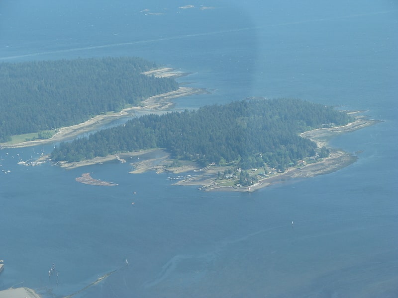
Island in Nanaimo, British Columbia. Protection Island is a small island located 1.5 km north-east of downtown Nanaimo, British Columbia, Canada in the Nanaimo Harbour. The island was originally named Douglas Island, after James Douglas the first Governor of the Colony of Vancouver Island and British Columbia. It was renamed Protection Island in 1960. The permanent year-round population is about 350 people.
There are no paved roads on the island. Some residents move about the island in golf carts, others with cars, but most walk. Locals frequently transport their groceries from the community dock with their own wheelbarrows. Access to the island can be via private vessel or a small, privately run ferry which departs from downtown Nanaimo at Maffeo Sutton Park and docks at Dinghy Dock Pub on the island. Dinghy Dock Pub is Canada’s only registered floating pub. Some residents also commute by kayak or rowboat as well.[5]
Nanaimo Harbour
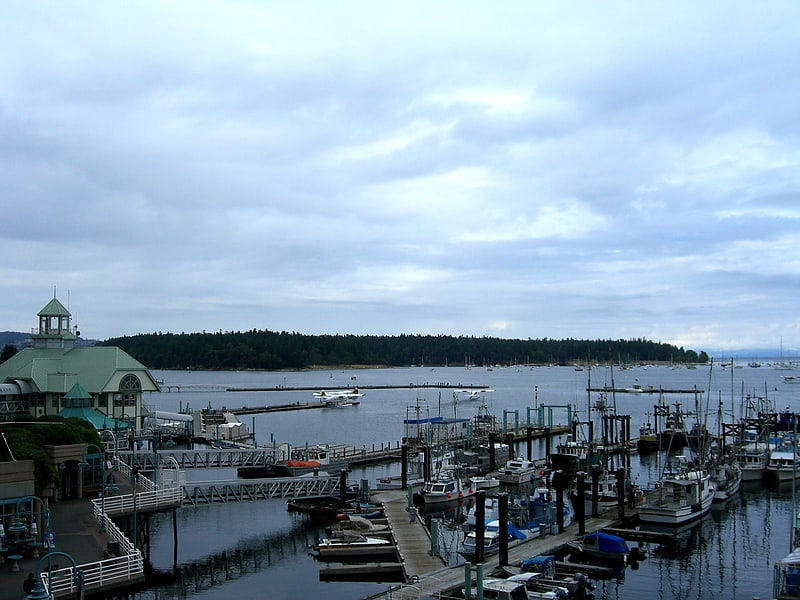
Nanaimo Harbour, also known as the Port of Nanaimo, is a natural harbour on the east coast of Vancouver Island, British Columbia, Canada. The City of Nanaimo runs along the west side of the harbour. Three islands, Newcastle, Protection, and Gabriola, along with Duke Point, form the eastern edge. The Port of Nanaimo includes the Inner Harbour, Nanaimo River estuary, Departure Bay, the waters on the east side of Newcastle and Protection Islands, and Northumberland Channel. The port is under the management of the Nanaimo Port Authority.[6]
Duke Point Ferry Terminal
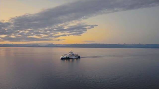
Boat or ferry, Bridge
Address: 400 Duke Point Hwy, V9X 1H6 Nanaimo
Buttertubs Marsh
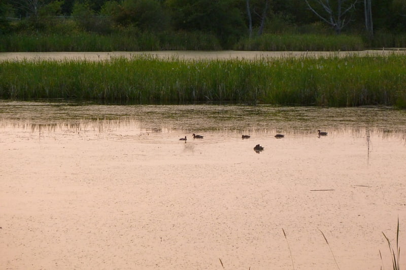
Park in Nanaimo, British Columbia. Buttertubs Marsh is a bird sanctuary in Nanaimo, British Columbia, Canada.
Located in the middle of the city of Nanaimo, the marsh covers approximately 100 acres (40 hectares). Within this is the 46 acre (18.7 hectare) Buttertubs Marsh Conservation Area, owned by the Nature Trust of British Columbia.
The marsh is man-made and is home to great blue herons, mallards, Canada geese, ring-necked ducks, hooded mergansers, American wigeons, violet-green swallows and red-winged blackbirds.
The sanctuary is Vancouver Island's only documented breeding site of American bittern.
Approximately half of the wetland area is privately owned, and efforts are underway to purchase the remaining land to protect it against development. Some residential development has already taken place on the eastern edge of the site.[7]
Harewood Skatepark
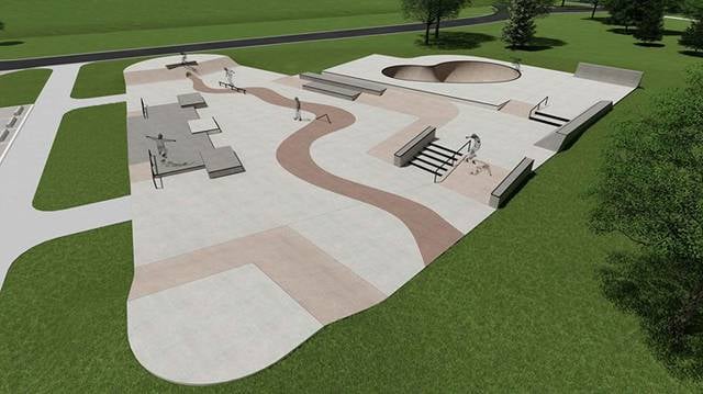
Park, Relax in park
Address: Howard Ave, Nanaimo (Harewood)
Petroglyph Provincial Park
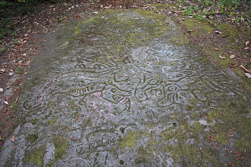
Provincial park in Nanaimo, British Columbia. Petroglyph Provincial Park is a provincial park located at the south end of the city of Nanaimo in British Columbia, Canada. The park was established on August 24, 1948 to protect a collection of petroglyphs found near the estuary of the Nanaimo River.[8]
Duke Point
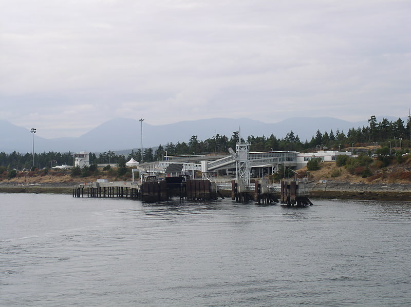
Duke Point is a geographical location in the extreme southeastern part of the city of Nanaimo in British Columbia. It is located on a thin peninsula to the east of the Nanaimo River estuary, just across the Northumberland Channel from Gabriola Island.
An industrial park is located at Duke Point, which includes one sawmill. The Duke Point ferry terminal is also located here, but there are no public transit connections.[9]