Discover 11 hidden attractions, cool sights, and unusual things to do in Grimsby (Canada). Don't miss out on these must-see attractions: Beamer Memorial Conservation Area, Dewitt Falls, and Fruitland Falls. Also, be sure to include McNeilly Falls in your itinerary.
Below, you can find the list of the most amazing places you should visit in Grimsby (Ontario).
Table of Contents
Beamer Memorial Conservation Area
Nature preserve in Grimsby, Ontario. Beamer Memorial Conservation Area is located on the Niagara Escarpment in Grimsby, Ontario, Canada, and is owned and operated by the Niagara Peninsula Conservation Authority. It is noted for being the best location on the Niagara Peninsula to observe the annual spring migration of raptors.[1]
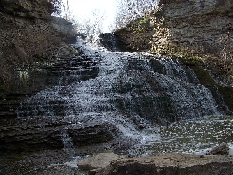
Dewitt Falls

The city of Hamilton in Ontario, Canada is home to more than 100 waterfalls and cascades, most of which are on or near the Bruce Trail as it winds through the Niagara Escarpment. Ontario's internationally recognized Niagara Escarpment provides perfect geological conditions for waterfalls to occur, from Tobermory to Niagara Falls.
The most scenic waterfall in Hamilton is Webster's Falls. With its 30 metres (98 ft) crest, it is the largest waterfall within the city. Tew's Falls is a 41 metres (135 ft) ribbon waterfall, and is the tallest waterfall found in Hamilton. Both Webster's and Tew's are located at the Spencer Gorge / Webster's Falls Conservation Area. Albion Falls was once seriously considered as a possible source of water for Hamilton. Rocks from the Albion Falls area were used in the construction of the Royal Botanical Gardens' Rock Garden.
There used to be more waterfalls in Hamilton than exist today. Many of the waterfalls in central Hamilton slowly vanished as population and construction on Hamilton Mountain increased. As well, in the early years, James Street extended south, but was interrupted by a bog at Hunter Street which eventually (1844) was drained out and graded. Many of Hamilton's main buildings and factories in the north end are built on reclaimed or infilled land, which harmed the drainage of Hamilton and the water ecology of Hamilton Harbour.
Many of the falls in west Hamilton are accessible from the Chedoke Radial Trail. It is built on what was once the route for the Brantford and Hamilton Electric Railway owned by the Cataract Power Light and Traction Company (later Dominion Power and Transmission). The "Five Johns", (John Cameron, John Dickenson (Canadian politician), John Morison Gibson, John Moodie, Sr. and John Sutherland), formed The Cataract Power Co. Ltd. introducing electric power to Hamilton in 1898. On August 25, 1898, power was sent twenty seven miles from DeCew Falls, St. Catharines, using water from the old Welland Canal. New industries, such as the forerunners of the Steel Co. of Canada (Stelco) and Canadian Westinghouse, were attracted here by the cheaper, more efficient power. One time this Company controlled hydro power from Brantford to St. Catharines, including the Hamilton Street Railway and the area's radial lines. Back then the city's nickname was "The Electric City."
There are four waterfall types and they are designated as follows:
- Ribbon – height is notably greater than its crest width; stream forms a thin ribbon of water.
- Classical – height and crest width are nearly equal.
- Curtain – height is notably smaller than its crest width.
- Cascade – vertical drop is broken into a series of steps causing water to cascade down incline.
Some of the criteria used to define a separate Hamilton waterfall include: The waterfall has to have a vertical drop of at least 3 metres or 10 feet (3.0 m) either as a vertical drop or a cascade, the crest width has to be at least 1 metre or 3 feet (0.91 m) wide, the waterfall must have some natural component and not be entirely man-made; If a waterfall is beside another waterfall but coming from two separate creeks or streams, then they could be considered as two separate waterfalls and the waterfall has to be located within the boundaries of the new City of Hamilton.
On January 1, 2001 the new city of Hamilton was formed from the amalgamation of the Regional Municipality of Hamilton-Wentworth and its six municipalities: Hamilton, Ancaster, Dundas, Flamborough, Glanbrook, and Stoney Creek. Before amalgamation, Hamilton had a population of 331,121 divided into 100 neighbourhoods. The new amalgamated city had 490,268 people in over 200 neighbourhoods.[2]
Fruitland Falls
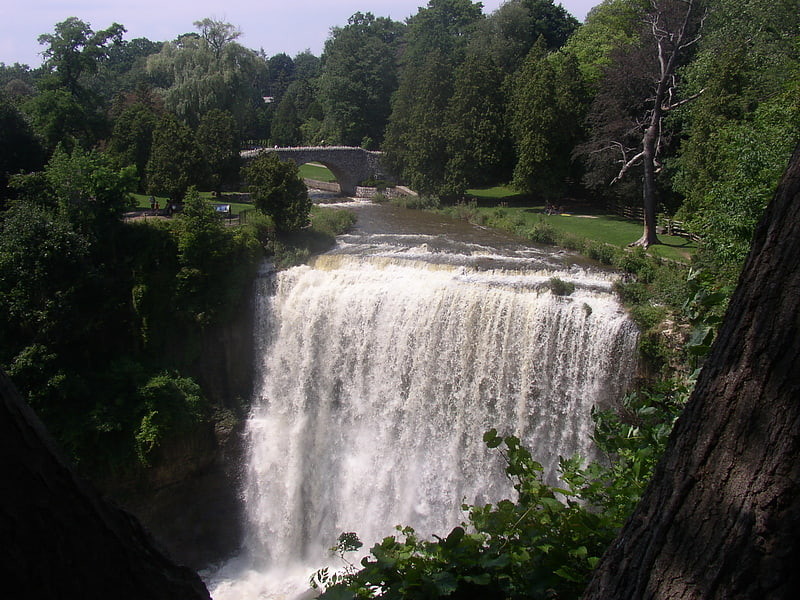
The city of Hamilton in Ontario, Canada is home to more than 100 waterfalls and cascades, most of which are on or near the Bruce Trail as it winds through the Niagara Escarpment. Ontario's internationally recognized Niagara Escarpment provides perfect geological conditions for waterfalls to occur, from Tobermory to Niagara Falls.
The most scenic waterfall in Hamilton is Webster's Falls. With its 30 metres (98 ft) crest, it is the largest waterfall within the city. Tew's Falls is a 41 metres (135 ft) ribbon waterfall, and is the tallest waterfall found in Hamilton. Both Webster's and Tew's are located at the Spencer Gorge / Webster's Falls Conservation Area. Albion Falls was once seriously considered as a possible source of water for Hamilton. Rocks from the Albion Falls area were used in the construction of the Royal Botanical Gardens' Rock Garden.
There used to be more waterfalls in Hamilton than exist today. Many of the waterfalls in central Hamilton slowly vanished as population and construction on Hamilton Mountain increased. As well, in the early years, James Street extended south, but was interrupted by a bog at Hunter Street which eventually (1844) was drained out and graded. Many of Hamilton's main buildings and factories in the north end are built on reclaimed or infilled land, which harmed the drainage of Hamilton and the water ecology of Hamilton Harbour.
Many of the falls in west Hamilton are accessible from the Chedoke Radial Trail. It is built on what was once the route for the Brantford and Hamilton Electric Railway owned by the Cataract Power Light and Traction Company (later Dominion Power and Transmission). The "Five Johns", (John Cameron, John Dickenson (Canadian politician), John Morison Gibson, John Moodie, Sr. and John Sutherland), formed The Cataract Power Co. Ltd. introducing electric power to Hamilton in 1898. On August 25, 1898, power was sent twenty seven miles from DeCew Falls, St. Catharines, using water from the old Welland Canal. New industries, such as the forerunners of the Steel Co. of Canada (Stelco) and Canadian Westinghouse, were attracted here by the cheaper, more efficient power. One time this Company controlled hydro power from Brantford to St. Catharines, including the Hamilton Street Railway and the area's radial lines. Back then the city's nickname was "The Electric City."
There are four waterfall types and they are designated as follows:
- Ribbon – height is notably greater than its crest width; stream forms a thin ribbon of water.
- Classical – height and crest width are nearly equal.
- Curtain – height is notably smaller than its crest width.
- Cascade – vertical drop is broken into a series of steps causing water to cascade down incline.
Some of the criteria used to define a separate Hamilton waterfall include: The waterfall has to have a vertical drop of at least 3 metres or 10 feet (3.0 m) either as a vertical drop or a cascade, the crest width has to be at least 1 metre or 3 feet (0.91 m) wide, the waterfall must have some natural component and not be entirely man-made; If a waterfall is beside another waterfall but coming from two separate creeks or streams, then they could be considered as two separate waterfalls and the waterfall has to be located within the boundaries of the new City of Hamilton.
On January 1, 2001 the new city of Hamilton was formed from the amalgamation of the Regional Municipality of Hamilton-Wentworth and its six municipalities: Hamilton, Ancaster, Dundas, Flamborough, Glanbrook, and Stoney Creek. Before amalgamation, Hamilton had a population of 331,121 divided into 100 neighbourhoods. The new amalgamated city had 490,268 people in over 200 neighbourhoods.[3]
McNeilly Falls

The city of Hamilton in Ontario, Canada is home to more than 100 waterfalls and cascades, most of which are on or near the Bruce Trail as it winds through the Niagara Escarpment. Ontario's internationally recognized Niagara Escarpment provides perfect geological conditions for waterfalls to occur, from Tobermory to Niagara Falls.
The most scenic waterfall in Hamilton is Webster's Falls. With its 30 metres (98 ft) crest, it is the largest waterfall within the city. Tew's Falls is a 41 metres (135 ft) ribbon waterfall, and is the tallest waterfall found in Hamilton. Both Webster's and Tew's are located at the Spencer Gorge / Webster's Falls Conservation Area. Albion Falls was once seriously considered as a possible source of water for Hamilton. Rocks from the Albion Falls area were used in the construction of the Royal Botanical Gardens' Rock Garden.
There used to be more waterfalls in Hamilton than exist today. Many of the waterfalls in central Hamilton slowly vanished as population and construction on Hamilton Mountain increased. As well, in the early years, James Street extended south, but was interrupted by a bog at Hunter Street which eventually (1844) was drained out and graded. Many of Hamilton's main buildings and factories in the north end are built on reclaimed or infilled land, which harmed the drainage of Hamilton and the water ecology of Hamilton Harbour.
Many of the falls in west Hamilton are accessible from the Chedoke Radial Trail. It is built on what was once the route for the Brantford and Hamilton Electric Railway owned by the Cataract Power Light and Traction Company (later Dominion Power and Transmission). The "Five Johns", (John Cameron, John Dickenson (Canadian politician), John Morison Gibson, John Moodie, Sr. and John Sutherland), formed The Cataract Power Co. Ltd. introducing electric power to Hamilton in 1898. On August 25, 1898, power was sent twenty seven miles from DeCew Falls, St. Catharines, using water from the old Welland Canal. New industries, such as the forerunners of the Steel Co. of Canada (Stelco) and Canadian Westinghouse, were attracted here by the cheaper, more efficient power. One time this Company controlled hydro power from Brantford to St. Catharines, including the Hamilton Street Railway and the area's radial lines. Back then the city's nickname was "The Electric City."
There are four waterfall types and they are designated as follows:
- Ribbon – height is notably greater than its crest width; stream forms a thin ribbon of water.
- Classical – height and crest width are nearly equal.
- Curtain – height is notably smaller than its crest width.
- Cascade – vertical drop is broken into a series of steps causing water to cascade down incline.
Some of the criteria used to define a separate Hamilton waterfall include: The waterfall has to have a vertical drop of at least 3 metres or 10 feet (3.0 m) either as a vertical drop or a cascade, the crest width has to be at least 1 metre or 3 feet (0.91 m) wide, the waterfall must have some natural component and not be entirely man-made; If a waterfall is beside another waterfall but coming from two separate creeks or streams, then they could be considered as two separate waterfalls and the waterfall has to be located within the boundaries of the new City of Hamilton.
On January 1, 2001 the new city of Hamilton was formed from the amalgamation of the Regional Municipality of Hamilton-Wentworth and its six municipalities: Hamilton, Ancaster, Dundas, Flamborough, Glanbrook, and Stoney Creek. Before amalgamation, Hamilton had a population of 331,121 divided into 100 neighbourhoods. The new amalgamated city had 490,268 people in over 200 neighbourhoods.[4]
Puddicombe Falls

The city of Hamilton in Ontario, Canada is home to more than 100 waterfalls and cascades, most of which are on or near the Bruce Trail as it winds through the Niagara Escarpment. Ontario's internationally recognized Niagara Escarpment provides perfect geological conditions for waterfalls to occur, from Tobermory to Niagara Falls.
The most scenic waterfall in Hamilton is Webster's Falls. With its 30 metres (98 ft) crest, it is the largest waterfall within the city. Tew's Falls is a 41 metres (135 ft) ribbon waterfall, and is the tallest waterfall found in Hamilton. Both Webster's and Tew's are located at the Spencer Gorge / Webster's Falls Conservation Area. Albion Falls was once seriously considered as a possible source of water for Hamilton. Rocks from the Albion Falls area were used in the construction of the Royal Botanical Gardens' Rock Garden.
There used to be more waterfalls in Hamilton than exist today. Many of the waterfalls in central Hamilton slowly vanished as population and construction on Hamilton Mountain increased. As well, in the early years, James Street extended south, but was interrupted by a bog at Hunter Street which eventually (1844) was drained out and graded. Many of Hamilton's main buildings and factories in the north end are built on reclaimed or infilled land, which harmed the drainage of Hamilton and the water ecology of Hamilton Harbour.
Many of the falls in west Hamilton are accessible from the Chedoke Radial Trail. It is built on what was once the route for the Brantford and Hamilton Electric Railway owned by the Cataract Power Light and Traction Company (later Dominion Power and Transmission). The "Five Johns", (John Cameron, John Dickenson (Canadian politician), John Morison Gibson, John Moodie, Sr. and John Sutherland), formed The Cataract Power Co. Ltd. introducing electric power to Hamilton in 1898. On August 25, 1898, power was sent twenty seven miles from DeCew Falls, St. Catharines, using water from the old Welland Canal. New industries, such as the forerunners of the Steel Co. of Canada (Stelco) and Canadian Westinghouse, were attracted here by the cheaper, more efficient power. One time this Company controlled hydro power from Brantford to St. Catharines, including the Hamilton Street Railway and the area's radial lines. Back then the city's nickname was "The Electric City."
There are four waterfall types and they are designated as follows:
- Ribbon – height is notably greater than its crest width; stream forms a thin ribbon of water.
- Classical – height and crest width are nearly equal.
- Curtain – height is notably smaller than its crest width.
- Cascade – vertical drop is broken into a series of steps causing water to cascade down incline.
Some of the criteria used to define a separate Hamilton waterfall include: The waterfall has to have a vertical drop of at least 3 metres or 10 feet (3.0 m) either as a vertical drop or a cascade, the crest width has to be at least 1 metre or 3 feet (0.91 m) wide, the waterfall must have some natural component and not be entirely man-made; If a waterfall is beside another waterfall but coming from two separate creeks or streams, then they could be considered as two separate waterfalls and the waterfall has to be located within the boundaries of the new City of Hamilton.
On January 1, 2001 the new city of Hamilton was formed from the amalgamation of the Regional Municipality of Hamilton-Wentworth and its six municipalities: Hamilton, Ancaster, Dundas, Flamborough, Glanbrook, and Stoney Creek. Before amalgamation, Hamilton had a population of 331,121 divided into 100 neighbourhoods. The new amalgamated city had 490,268 people in over 200 neighbourhoods.[5]
Jones Road Falls

The city of Hamilton in Ontario, Canada is home to more than 100 waterfalls and cascades, most of which are on or near the Bruce Trail as it winds through the Niagara Escarpment. Ontario's internationally recognized Niagara Escarpment provides perfect geological conditions for waterfalls to occur, from Tobermory to Niagara Falls.
The most scenic waterfall in Hamilton is Webster's Falls. With its 30 metres (98 ft) crest, it is the largest waterfall within the city. Tew's Falls is a 41 metres (135 ft) ribbon waterfall, and is the tallest waterfall found in Hamilton. Both Webster's and Tew's are located at the Spencer Gorge / Webster's Falls Conservation Area. Albion Falls was once seriously considered as a possible source of water for Hamilton. Rocks from the Albion Falls area were used in the construction of the Royal Botanical Gardens' Rock Garden.
There used to be more waterfalls in Hamilton than exist today. Many of the waterfalls in central Hamilton slowly vanished as population and construction on Hamilton Mountain increased. As well, in the early years, James Street extended south, but was interrupted by a bog at Hunter Street which eventually (1844) was drained out and graded. Many of Hamilton's main buildings and factories in the north end are built on reclaimed or infilled land, which harmed the drainage of Hamilton and the water ecology of Hamilton Harbour.
Many of the falls in west Hamilton are accessible from the Chedoke Radial Trail. It is built on what was once the route for the Brantford and Hamilton Electric Railway owned by the Cataract Power Light and Traction Company (later Dominion Power and Transmission). The "Five Johns", (John Cameron, John Dickenson (Canadian politician), John Morison Gibson, John Moodie, Sr. and John Sutherland), formed The Cataract Power Co. Ltd. introducing electric power to Hamilton in 1898. On August 25, 1898, power was sent twenty seven miles from DeCew Falls, St. Catharines, using water from the old Welland Canal. New industries, such as the forerunners of the Steel Co. of Canada (Stelco) and Canadian Westinghouse, were attracted here by the cheaper, more efficient power. One time this Company controlled hydro power from Brantford to St. Catharines, including the Hamilton Street Railway and the area's radial lines. Back then the city's nickname was "The Electric City."
There are four waterfall types and they are designated as follows:
- Ribbon – height is notably greater than its crest width; stream forms a thin ribbon of water.
- Classical – height and crest width are nearly equal.
- Curtain – height is notably smaller than its crest width.
- Cascade – vertical drop is broken into a series of steps causing water to cascade down incline.
Some of the criteria used to define a separate Hamilton waterfall include: The waterfall has to have a vertical drop of at least 3 metres or 10 feet (3.0 m) either as a vertical drop or a cascade, the crest width has to be at least 1 metre or 3 feet (0.91 m) wide, the waterfall must have some natural component and not be entirely man-made; If a waterfall is beside another waterfall but coming from two separate creeks or streams, then they could be considered as two separate waterfalls and the waterfall has to be located within the boundaries of the new City of Hamilton.
On January 1, 2001 the new city of Hamilton was formed from the amalgamation of the Regional Municipality of Hamilton-Wentworth and its six municipalities: Hamilton, Ancaster, Dundas, Flamborough, Glanbrook, and Stoney Creek. Before amalgamation, Hamilton had a population of 331,121 divided into 100 neighbourhoods. The new amalgamated city had 490,268 people in over 200 neighbourhoods.[6]
Tallman West Falls

The city of Hamilton in Ontario, Canada is home to more than 100 waterfalls and cascades, most of which are on or near the Bruce Trail as it winds through the Niagara Escarpment. Ontario's internationally recognized Niagara Escarpment provides perfect geological conditions for waterfalls to occur, from Tobermory to Niagara Falls.
The most scenic waterfall in Hamilton is Webster's Falls. With its 30 metres (98 ft) crest, it is the largest waterfall within the city. Tew's Falls is a 41 metres (135 ft) ribbon waterfall, and is the tallest waterfall found in Hamilton. Both Webster's and Tew's are located at the Spencer Gorge / Webster's Falls Conservation Area. Albion Falls was once seriously considered as a possible source of water for Hamilton. Rocks from the Albion Falls area were used in the construction of the Royal Botanical Gardens' Rock Garden.
There used to be more waterfalls in Hamilton than exist today. Many of the waterfalls in central Hamilton slowly vanished as population and construction on Hamilton Mountain increased. As well, in the early years, James Street extended south, but was interrupted by a bog at Hunter Street which eventually (1844) was drained out and graded. Many of Hamilton's main buildings and factories in the north end are built on reclaimed or infilled land, which harmed the drainage of Hamilton and the water ecology of Hamilton Harbour.
Many of the falls in west Hamilton are accessible from the Chedoke Radial Trail. It is built on what was once the route for the Brantford and Hamilton Electric Railway owned by the Cataract Power Light and Traction Company (later Dominion Power and Transmission). The "Five Johns", (John Cameron, John Dickenson (Canadian politician), John Morison Gibson, John Moodie, Sr. and John Sutherland), formed The Cataract Power Co. Ltd. introducing electric power to Hamilton in 1898. On August 25, 1898, power was sent twenty seven miles from DeCew Falls, St. Catharines, using water from the old Welland Canal. New industries, such as the forerunners of the Steel Co. of Canada (Stelco) and Canadian Westinghouse, were attracted here by the cheaper, more efficient power. One time this Company controlled hydro power from Brantford to St. Catharines, including the Hamilton Street Railway and the area's radial lines. Back then the city's nickname was "The Electric City."
There are four waterfall types and they are designated as follows:
- Ribbon – height is notably greater than its crest width; stream forms a thin ribbon of water.
- Classical – height and crest width are nearly equal.
- Curtain – height is notably smaller than its crest width.
- Cascade – vertical drop is broken into a series of steps causing water to cascade down incline.
Some of the criteria used to define a separate Hamilton waterfall include: The waterfall has to have a vertical drop of at least 3 metres or 10 feet (3.0 m) either as a vertical drop or a cascade, the crest width has to be at least 1 metre or 3 feet (0.91 m) wide, the waterfall must have some natural component and not be entirely man-made; If a waterfall is beside another waterfall but coming from two separate creeks or streams, then they could be considered as two separate waterfalls and the waterfall has to be located within the boundaries of the new City of Hamilton.
On January 1, 2001 the new city of Hamilton was formed from the amalgamation of the Regional Municipality of Hamilton-Wentworth and its six municipalities: Hamilton, Ancaster, Dundas, Flamborough, Glanbrook, and Stoney Creek. Before amalgamation, Hamilton had a population of 331,121 divided into 100 neighbourhoods. The new amalgamated city had 490,268 people in over 200 neighbourhoods.[7]
Tallman East Falls

The city of Hamilton in Ontario, Canada is home to more than 100 waterfalls and cascades, most of which are on or near the Bruce Trail as it winds through the Niagara Escarpment. Ontario's internationally recognized Niagara Escarpment provides perfect geological conditions for waterfalls to occur, from Tobermory to Niagara Falls.
The most scenic waterfall in Hamilton is Webster's Falls. With its 30 metres (98 ft) crest, it is the largest waterfall within the city. Tew's Falls is a 41 metres (135 ft) ribbon waterfall, and is the tallest waterfall found in Hamilton. Both Webster's and Tew's are located at the Spencer Gorge / Webster's Falls Conservation Area. Albion Falls was once seriously considered as a possible source of water for Hamilton. Rocks from the Albion Falls area were used in the construction of the Royal Botanical Gardens' Rock Garden.
There used to be more waterfalls in Hamilton than exist today. Many of the waterfalls in central Hamilton slowly vanished as population and construction on Hamilton Mountain increased. As well, in the early years, James Street extended south, but was interrupted by a bog at Hunter Street which eventually (1844) was drained out and graded. Many of Hamilton's main buildings and factories in the north end are built on reclaimed or infilled land, which harmed the drainage of Hamilton and the water ecology of Hamilton Harbour.
Many of the falls in west Hamilton are accessible from the Chedoke Radial Trail. It is built on what was once the route for the Brantford and Hamilton Electric Railway owned by the Cataract Power Light and Traction Company (later Dominion Power and Transmission). The "Five Johns", (John Cameron, John Dickenson (Canadian politician), John Morison Gibson, John Moodie, Sr. and John Sutherland), formed The Cataract Power Co. Ltd. introducing electric power to Hamilton in 1898. On August 25, 1898, power was sent twenty seven miles from DeCew Falls, St. Catharines, using water from the old Welland Canal. New industries, such as the forerunners of the Steel Co. of Canada (Stelco) and Canadian Westinghouse, were attracted here by the cheaper, more efficient power. One time this Company controlled hydro power from Brantford to St. Catharines, including the Hamilton Street Railway and the area's radial lines. Back then the city's nickname was "The Electric City."
There are four waterfall types and they are designated as follows:
- Ribbon – height is notably greater than its crest width; stream forms a thin ribbon of water.
- Classical – height and crest width are nearly equal.
- Curtain – height is notably smaller than its crest width.
- Cascade – vertical drop is broken into a series of steps causing water to cascade down incline.
Some of the criteria used to define a separate Hamilton waterfall include: The waterfall has to have a vertical drop of at least 3 metres or 10 feet (3.0 m) either as a vertical drop or a cascade, the crest width has to be at least 1 metre or 3 feet (0.91 m) wide, the waterfall must have some natural component and not be entirely man-made; If a waterfall is beside another waterfall but coming from two separate creeks or streams, then they could be considered as two separate waterfalls and the waterfall has to be located within the boundaries of the new City of Hamilton.
On January 1, 2001 the new city of Hamilton was formed from the amalgamation of the Regional Municipality of Hamilton-Wentworth and its six municipalities: Hamilton, Ancaster, Dundas, Flamborough, Glanbrook, and Stoney Creek. Before amalgamation, Hamilton had a population of 331,121 divided into 100 neighbourhoods. The new amalgamated city had 490,268 people in over 200 neighbourhoods.[8]
Nelles Manor
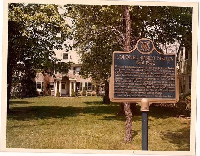
History museum, Museum
Address: 126 Main St W, L3M 1R8 Grimsby
Lewis Road East Falls

The city of Hamilton in Ontario, Canada is home to more than 100 waterfalls and cascades, most of which are on or near the Bruce Trail as it winds through the Niagara Escarpment. Ontario's internationally recognized Niagara Escarpment provides perfect geological conditions for waterfalls to occur, from Tobermory to Niagara Falls.
The most scenic waterfall in Hamilton is Webster's Falls. With its 30 metres (98 ft) crest, it is the largest waterfall within the city. Tew's Falls is a 41 metres (135 ft) ribbon waterfall, and is the tallest waterfall found in Hamilton. Both Webster's and Tew's are located at the Spencer Gorge / Webster's Falls Conservation Area. Albion Falls was once seriously considered as a possible source of water for Hamilton. Rocks from the Albion Falls area were used in the construction of the Royal Botanical Gardens' Rock Garden.
There used to be more waterfalls in Hamilton than exist today. Many of the waterfalls in central Hamilton slowly vanished as population and construction on Hamilton Mountain increased. As well, in the early years, James Street extended south, but was interrupted by a bog at Hunter Street which eventually (1844) was drained out and graded. Many of Hamilton's main buildings and factories in the north end are built on reclaimed or infilled land, which harmed the drainage of Hamilton and the water ecology of Hamilton Harbour.
Many of the falls in west Hamilton are accessible from the Chedoke Radial Trail. It is built on what was once the route for the Brantford and Hamilton Electric Railway owned by the Cataract Power Light and Traction Company (later Dominion Power and Transmission). The "Five Johns", (John Cameron, John Dickenson (Canadian politician), John Morison Gibson, John Moodie, Sr. and John Sutherland), formed The Cataract Power Co. Ltd. introducing electric power to Hamilton in 1898. On August 25, 1898, power was sent twenty seven miles from DeCew Falls, St. Catharines, using water from the old Welland Canal. New industries, such as the forerunners of the Steel Co. of Canada (Stelco) and Canadian Westinghouse, were attracted here by the cheaper, more efficient power. One time this Company controlled hydro power from Brantford to St. Catharines, including the Hamilton Street Railway and the area's radial lines. Back then the city's nickname was "The Electric City."
There are four waterfall types and they are designated as follows:
- Ribbon – height is notably greater than its crest width; stream forms a thin ribbon of water.
- Classical – height and crest width are nearly equal.
- Curtain – height is notably smaller than its crest width.
- Cascade – vertical drop is broken into a series of steps causing water to cascade down incline.
Some of the criteria used to define a separate Hamilton waterfall include: The waterfall has to have a vertical drop of at least 3 metres or 10 feet (3.0 m) either as a vertical drop or a cascade, the crest width has to be at least 1 metre or 3 feet (0.91 m) wide, the waterfall must have some natural component and not be entirely man-made; If a waterfall is beside another waterfall but coming from two separate creeks or streams, then they could be considered as two separate waterfalls and the waterfall has to be located within the boundaries of the new City of Hamilton.
On January 1, 2001 the new city of Hamilton was formed from the amalgamation of the Regional Municipality of Hamilton-Wentworth and its six municipalities: Hamilton, Ancaster, Dundas, Flamborough, Glanbrook, and Stoney Creek. Before amalgamation, Hamilton had a population of 331,121 divided into 100 neighbourhoods. The new amalgamated city had 490,268 people in over 200 neighbourhoods.[9]
Lewis Road West Falls

The city of Hamilton in Ontario, Canada is home to more than 100 waterfalls and cascades, most of which are on or near the Bruce Trail as it winds through the Niagara Escarpment. Ontario's internationally recognized Niagara Escarpment provides perfect geological conditions for waterfalls to occur, from Tobermory to Niagara Falls.
The most scenic waterfall in Hamilton is Webster's Falls. With its 30 metres (98 ft) crest, it is the largest waterfall within the city. Tew's Falls is a 41 metres (135 ft) ribbon waterfall, and is the tallest waterfall found in Hamilton. Both Webster's and Tew's are located at the Spencer Gorge / Webster's Falls Conservation Area. Albion Falls was once seriously considered as a possible source of water for Hamilton. Rocks from the Albion Falls area were used in the construction of the Royal Botanical Gardens' Rock Garden.
There used to be more waterfalls in Hamilton than exist today. Many of the waterfalls in central Hamilton slowly vanished as population and construction on Hamilton Mountain increased. As well, in the early years, James Street extended south, but was interrupted by a bog at Hunter Street which eventually (1844) was drained out and graded. Many of Hamilton's main buildings and factories in the north end are built on reclaimed or infilled land, which harmed the drainage of Hamilton and the water ecology of Hamilton Harbour.
Many of the falls in west Hamilton are accessible from the Chedoke Radial Trail. It is built on what was once the route for the Brantford and Hamilton Electric Railway owned by the Cataract Power Light and Traction Company (later Dominion Power and Transmission). The "Five Johns", (John Cameron, John Dickenson (Canadian politician), John Morison Gibson, John Moodie, Sr. and John Sutherland), formed The Cataract Power Co. Ltd. introducing electric power to Hamilton in 1898. On August 25, 1898, power was sent twenty seven miles from DeCew Falls, St. Catharines, using water from the old Welland Canal. New industries, such as the forerunners of the Steel Co. of Canada (Stelco) and Canadian Westinghouse, were attracted here by the cheaper, more efficient power. One time this Company controlled hydro power from Brantford to St. Catharines, including the Hamilton Street Railway and the area's radial lines. Back then the city's nickname was "The Electric City."
There are four waterfall types and they are designated as follows:
- Ribbon – height is notably greater than its crest width; stream forms a thin ribbon of water.
- Classical – height and crest width are nearly equal.
- Curtain – height is notably smaller than its crest width.
- Cascade – vertical drop is broken into a series of steps causing water to cascade down incline.
Some of the criteria used to define a separate Hamilton waterfall include: The waterfall has to have a vertical drop of at least 3 metres or 10 feet (3.0 m) either as a vertical drop or a cascade, the crest width has to be at least 1 metre or 3 feet (0.91 m) wide, the waterfall must have some natural component and not be entirely man-made; If a waterfall is beside another waterfall but coming from two separate creeks or streams, then they could be considered as two separate waterfalls and the waterfall has to be located within the boundaries of the new City of Hamilton.
On January 1, 2001 the new city of Hamilton was formed from the amalgamation of the Regional Municipality of Hamilton-Wentworth and its six municipalities: Hamilton, Ancaster, Dundas, Flamborough, Glanbrook, and Stoney Creek. Before amalgamation, Hamilton had a population of 331,121 divided into 100 neighbourhoods. The new amalgamated city had 490,268 people in over 200 neighbourhoods.[10]