Discover 35 hidden attractions, cool sights, and unusual things to do in Saskatoon (Canada). Don't miss out on these must-see attractions: Saskatchewan Railway Museum, Saskatoon Farmers' Market, and Western Development Museum. Also, be sure to include Marquis Downs in your itinerary.
Below, you can find the list of the most amazing places you should visit in Saskatoon (Saskatchewan).
Table of Contents
Saskatchewan Railway Museum
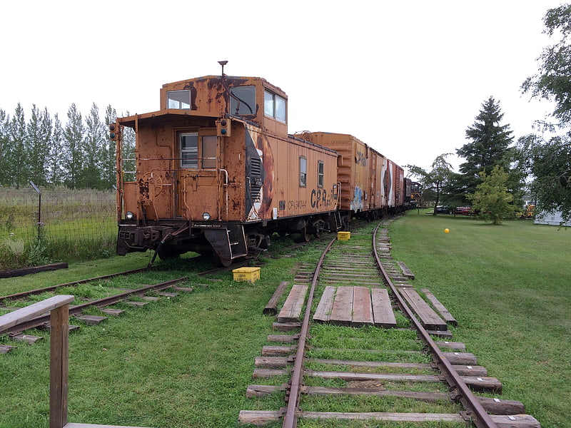
Museum in Saskatchewan, Canada. The Saskatchewan Railway Museum is a railway museum located west of Saskatoon, Saskatchewan at the intersection of the Pike Lake Highway and the Canadian National Railway tracks. It is operated by the Saskatchewan Railroad Historical Association and was opened in 1990.[1]
Address: Trans-Canada Hwy 60,, S7H 5N9 Saskatoon
Saskatoon Farmers' Market
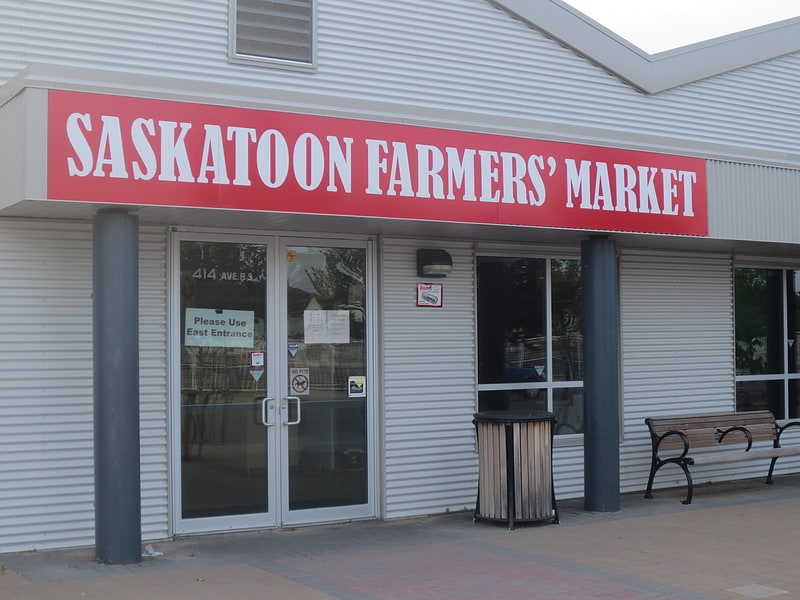
Farmers' market in Saskatoon, Saskatchewan. The Saskatoon Farmers' Market is a non-profit, vendor-owned cooperative that operates year-round, twice-weekly Farmers' market in Saskatoon, Saskatchewan, Canada. Featuring more than 100 vendors and resolutely supporting local makers, bakers, gatherers, and growers, the Saskatoon Farmers’ Market is a true and authentic farmers’ market. In addition to its year-round weekend markets at 2600 Koyl Ave, the Saskatoon Farmers' Market also operates seasonally on Wednesday evenings at the Spiffy Car Wash in Stonebridge. It also operates a virtual market online.[2]
Address: 414 Avenue B S, S7M 1M8 Saskatoon
Western Development Museum
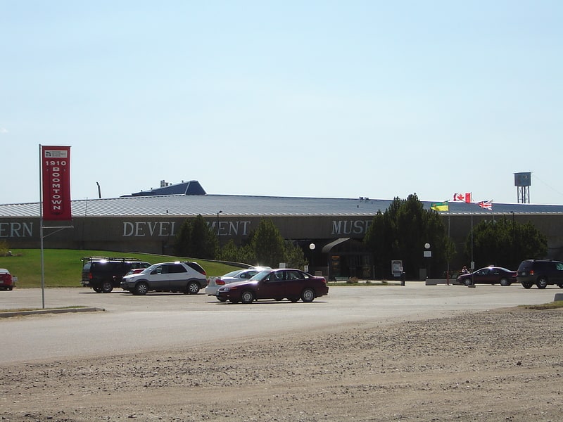
Museum in North Battleford, Saskatchewan. The Western Development Museum is a network of four museums in Saskatchewan, Canada preserving and recording the social and economic development of the province. The museum has branches in Moose Jaw, North Battleford, Saskatoon and Yorkton. Respectively, each branch focuses on a different theme: transportation, agriculture, economy, and people. The museum is affiliated with the Canadian Museums Association, the Canadian Heritage Information Network, and Virtual Museum of Canada.[3]
Address: 2610 Lorne Ave, S7J 0S6 Saskatoon (Nutana)
Marquis Downs
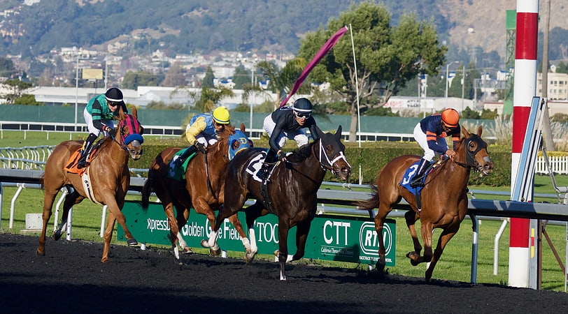
Sports venue in Saskatoon, Saskatchewan. Marquis Downs was a horse racing venue in the Exhibition subdivision of Saskatoon, Saskatchewan, Canada. It featured thoroughbred horse racing.[4]
Address: 503 Ruth St, Saskatoon (Nutana)
SaskTel Centre
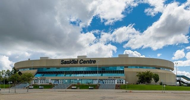
Arena in Saskatoon, Saskatchewan. SaskTel Centre is an arena located in the Agriplace Industrial Park, Saskatoon, Saskatchewan, Canada. With 15,195 permanent stadium seats, and situated near the city's northern entrance, the facility opened in February 1988 with a seating capacity of around 7,800. It was expanded to 11,330 for the World Junior Hockey Championships in 1990. Additional permanent seating was added in 2008 and 2009. The current capacity is 15,190 for hockey.
It is the home venue of the Saskatoon Blades of the Western Hockey League, the Saskatchewan Rattlers of the Canadian Elite Basketball League and the Saskatchewan Rush of the National Lacrosse League, with the arena being referred to as Co-op Field at SaskTel Centre during Rush games as per a separate sponsorship with Saskatoon Co-op.
The ashes of Saskatoon-born Detroit Red Wings player Gordie Howe, as well as those of his wife Colleen Howe, are buried at the base of a statue of Howe outside SaskTel Centre's main entrance.[5]
Address: Saskatoon, 3315 Thatcher Avenue
Diefenbaker Canada Centre
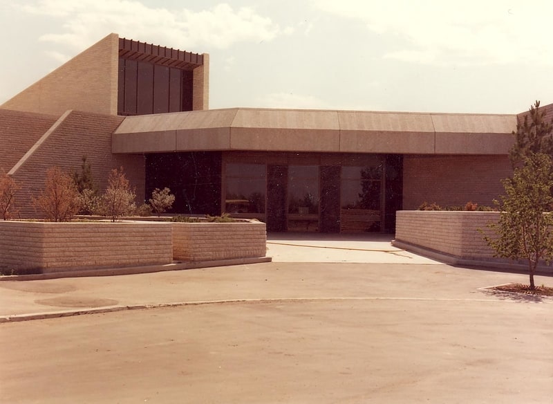
Museum in Saskatoon, Saskatchewan. The Right Honourable John G. Diefenbaker Centre for the Study of Canada, popularly known as the Diefenbaker Canada Centre, is a Prime Ministerial Museum and Archives located in Saskatoon, honouring Canada's 13th Prime Minister, the Rt. Hon. John G. Diefenbaker.
Upon his election as Chancellor of the University of Saskatchewan in 1969, Diefenbaker approached the University with an offer to donate his estate to the institution, on the condition that a museum and archives be built to house and display his items. Diefenbaker's inspiration in this regard was the Harry S. Truman Presidential Library and Museum in Independence, Missouri, which he had previously visited.
The University accepted Diefenbaker's donation. Construction began on the Centre, which opened on June 12, 1980.
The Centre's museum contains a permanent display on the life and career of Diefenbaker, highlighted by replica rooms of the Prime Minister's Office and Privy Council Chambers, as they existed on Parliament Hill during his governments from 1957-1963.
A portion of the museum is set aside for traveling exhibits related to his career interests. In 1997 one of these exhibitions was the site of a theft when items were stolen from an exhibition of French jewelry.
The Diefenbaker Canada Centre archives contains Diefenbaker's personal and professional papers, photographs, and audio-visual material, including his Prime Ministerial papers. The papers of Diefenbaker, and those of R.B. Bennett, are the only Prime Ministerial papers not housed at Library and Archives Canada.[6]
Address: 101 Diefenbaker Pl, S7N 5B8 Saskatoon (University Heights)
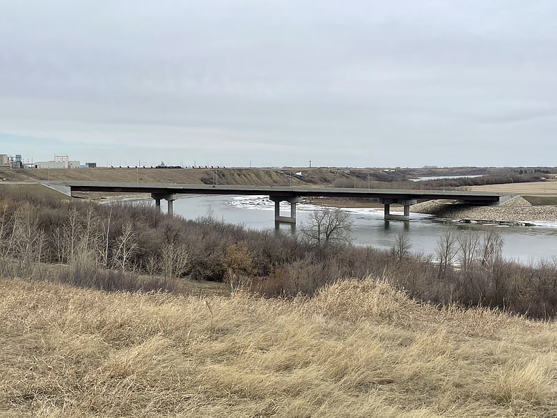
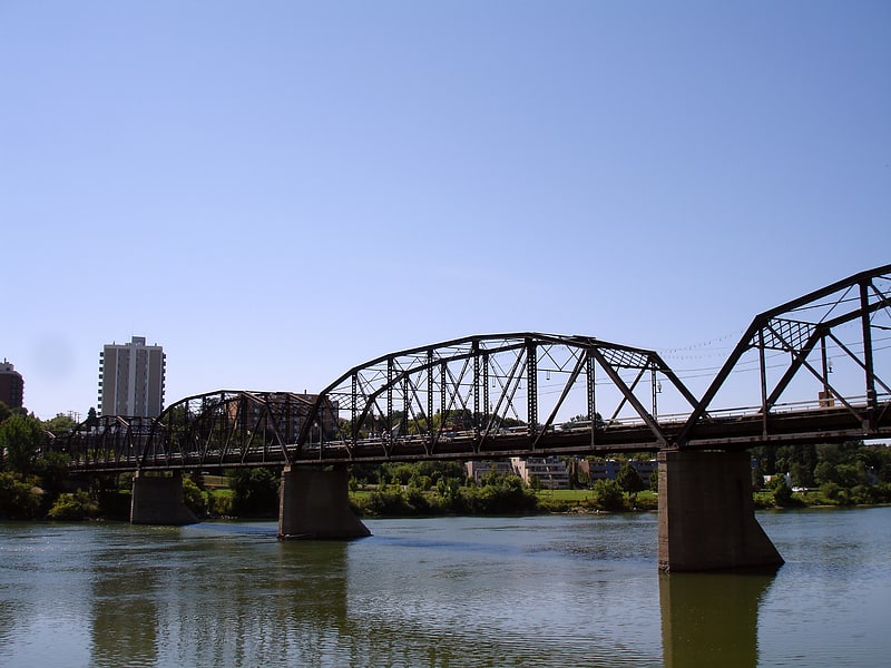
CPR
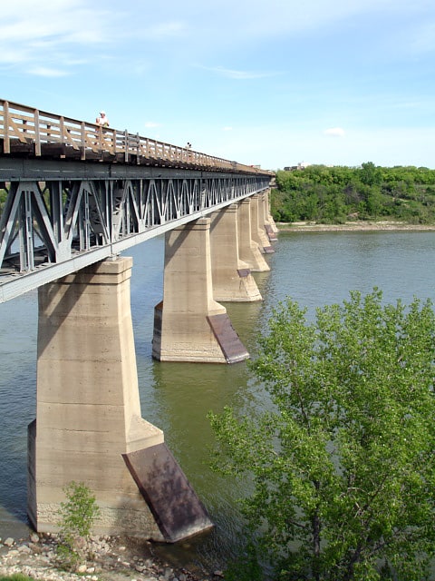
Truss bridge in Saskatoon, Saskatchewan. The CPR Bridge is a Canadian railway bridge that spans the South Saskatchewan River in Saskatoon, Saskatchewan.
The bridge was built by the Canadian Pacific Railway in 1908 and is referred to by locals as the CPR Bridge or CP Railway Bridge, or simply the Train Bridge or Railway Bridge. The city's second rail bridge, to avoid confusion, is generally known as the Grand Trunk Bridge or CN Railway Bridge; that second bridge opened several months before the CPR Bridge. With the demolition of the city's original Traffic Bridge in 2016 (it was subsequently replaced by a new structure), the CPR Bridge became the second-oldest surviving bridge in the city.
The CPR Bridge is part of the CP rail line to its Sutherland rail yards. It is unusual for a rail bridge in that it includes a pedestrian walkway, which was added in 1909. It allows users to cross between the west side of the bridge, adjacent to the Meewasin Valley trails, and the east side, near Innovation Place Research Park. The bridge stands 19.5 metres (64 ft) above the river.
Originally, the City of Saskatoon asked that the bridge be designed so that a single lane of vehicular traffic could be added later. However, this plan was abandoned and the University Bridge was instead built upstream.
The bridge is referred to on page 1 of Farley Mowat's 1961 novella, Owls in the Family; Mowat refers to the bridge by a variation of its nickname, The Railroad Bridge.[7]
Broadway Bridge
Arch bridge in Saskatoon, Saskatchewan. Broadway Bridge is an arch bridge that spans the South Saskatchewan River in Saskatoon, Saskatchewan, Canada.[8]
Broadway Theatre
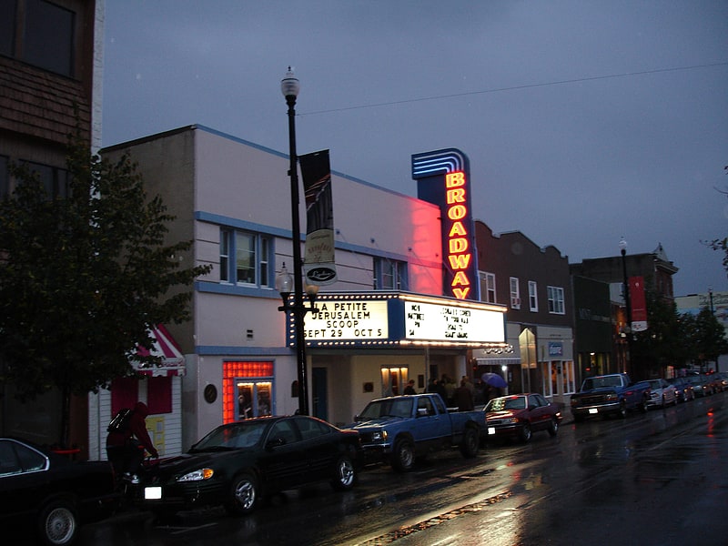
Theatre in Saskatoon, Saskatchewan. The Broadway Theatre is an art film and performance theatre located on Broadway Avenue in the Nutana neighborhood of Saskatoon, Saskatchewan, Canada. The theatre is Canada's only community-owned non-profit repertory cinema.[9]
Address: Saskatoon, 715 Broadway Avenue
Forestry Farm Park and Zoo
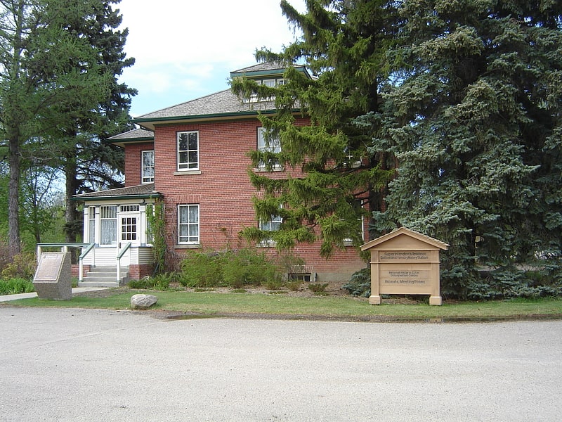
Rustic ecological park with animals. The Forestry Farm Park and Zoo is a forested park and zoo located in Saskatoon, Saskatchewan, Canada. The park was originally established as the Dominion Forest Nursery Station and later Sutherland Forest Nursery Station. Between 1913-1966 was responsible for growing and shipping 147 million trees shipped across the northern prairie provinces. The first shipment of trees were sent to farmers in 1916. The park is designated a National Historic Site of Canada. The nursery grew caragana, ash, maple, elm, and willow. After the nursery closed in 1966 a portion was re-opened as a city park.
The park contains the following areas:
- Forestry Farm House (The Superintendent's Residence) – is a historical farm house of a Georgian brink design built in 1913 located within the park. The building was officially designated a heritage property on July 3, 1990.
- Hall – With a capacity of 225 people
- Gazebo Picnic Site – With seating for up to 100 people
- Fishing Pond – A Pond stocked with Rainbow Trout (daily permit required)
- Kinsmen Express Zoo Train – Guided tour through the zoo area
- Paws Inn Concession and Gift Shop – A Concession Stand and Gift Shop operated by the Zoo Society
- Meditation Garden – Cared for by the Perennial Society
- Heritage Rose Garden – Cared for by the Perennial Society
- Zoo – The zoo facilities
- Demonstration Forest – Original demonstration forest once part of the nursery.
Developed long before any major residential development in the region, since the 1990s the park has been virtually surrounded by Saskatoon's urban sprawl, casting the Forestry Farm, along with several contiguous linear parks, in an additional role as part of the region's greenbelt.[10]
Address: 1903 Forest Dr, S7S 1G9 Saskatoon (University Heights)
Marr Residence
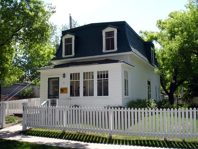
Monument in Saskatoon, Saskatchewan. The Marr Residence is a National Historic Site located in the Nutana neighbourhood of Saskatoon, Saskatchewan, and was part of the original temperance colony that predated the city. Built in 1884 for stonemason Alexander "Sandy" Marr, it is the oldest building in Saskatoon on its original site. It was one of several houses requisitioned as a field hospital to treat wounded soldiers during the North-West Rebellion in 1885. When the hospital was closed in 1885 the home was returned to the Marr family. Although they left Saskatoon in 1889, the Marr family name remained associated with the house. The house remained a residential property until the 1970s.
The Marr Residence was designated a municipal heritage property on January 11, 1982. It is noted for its blend of Second Empire and pioneer architecture, particularly its Mansard roof. The building is currently owned by the City of Saskatoon.
On July 4, 2016, the Marr Residence was designated a National Historic Site.[11]
Address: Saskatoon, 326 11th Street East
Wanuskewin Heritage Park
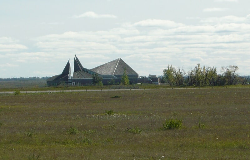
Heritage museum in Saskatchewan, Canada. Wanuskewin Heritage Park is a non-profit cultural and historical centre of the First Nations. The site is a National Historic Site of Canada due to the importance of its archaeological resources representing nearly 6000 years of the history of the Northern Plains peoples. In 2016, it was announced that Wanuskewin intends to seek UNESCO World Heritage designation, which would make it the first World Heritage Site in Saskatchewan.[12]
Address: Penner Rd, S7K 3J7 Saskatoon
Cathedral of St. John the Evangelist
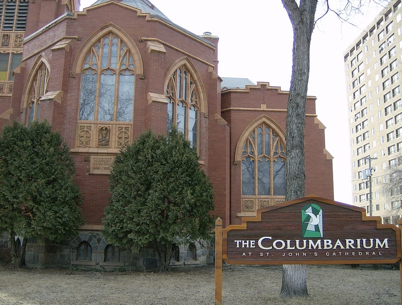
The Cathedral of St. John the Evangelist, located at 816 Spadina Crescent East in the Central Business District neighbourhood of Saskatoon, Saskatchewan, Canada is the cathedral of the Anglican Diocese of Saskatoon.[13]
Address: 816 Spadina Crescent E, S7K 3H4 Saskatoon
Museum of Antiquities
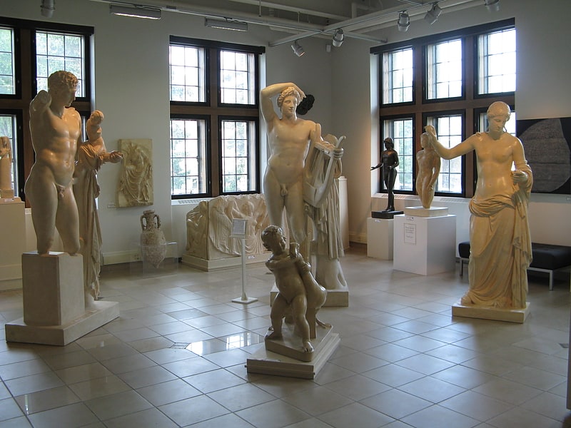
Museum in Saskatoon, Saskatchewan. The Museum of Antiquities is an archaeological museum at the University of Saskatchewan in Saskatoon, Canada. It opened in 1974 to provide an opportunity to study ancient works. The Museum currently features a variety of Greek and Roman sculpture, and contains a collection of Near Eastern, Egyptian, Byzantine, Islamic and Medieval art. It is one of only a handful of museums of its kind in Canada.[14]
Address: Administration Place, Saskatoon (University Heights)
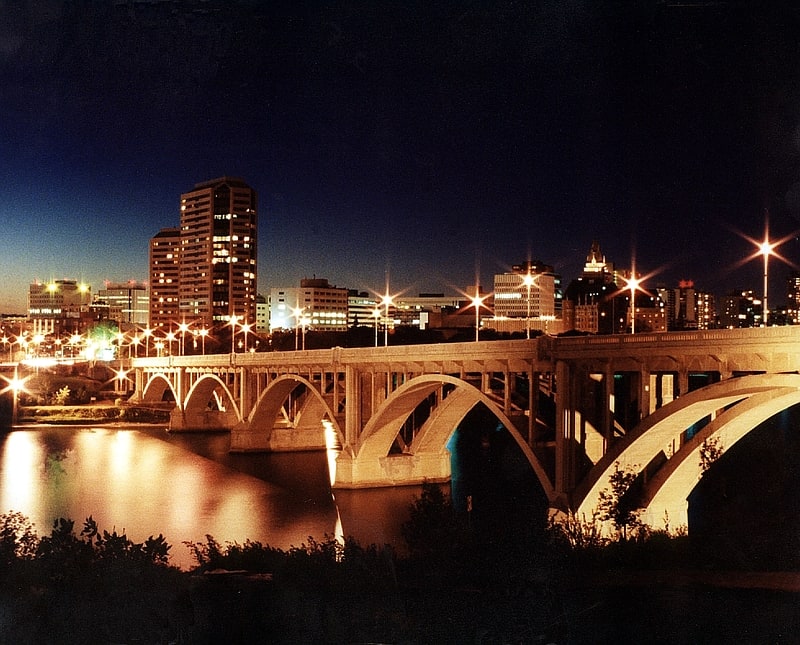
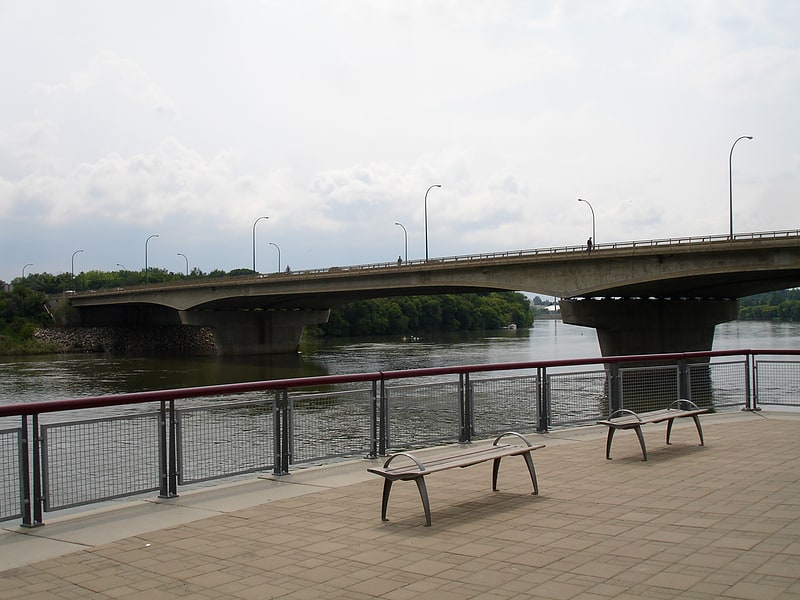
University Bridge
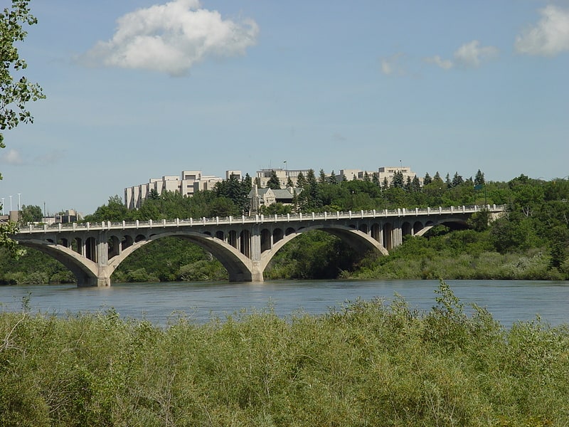
Bridge in Saskatoon, Saskatchewan. The University Bridge spans the South Saskatchewan River between Clarence Avenue and College Drive on the east shore with 25th Street on the west in Saskatoon, Saskatchewan Canada. The bridge is also known as the 25th Street Bridge and is a major commuter route between the two halves of Saskatoon. Between its opening in 1916 and the opening of the Circle Drive Bridge in 1983, it was the northernmost vehicular river crossing in the city. It is named for the fact that it provides access to the University of Saskatchewan.
The University Bridge was originally planned to be of steel truss construction, much like the Traffic Bridge. Instead, a new design was used and Saskatoon saw the start of its first reinforced concrete arch bridge in 1913. Unfortunately the original contractor, R.J. Lecky, badly underbid on the tender, had problems with its concrete, and faced conflict of interest charges. One pier of the bridge had to be rebuilt and, due to the impact of the First World War on the global economy, the company went bankrupt and the provincial government had to finish building the bridge itself. When completed in 1916 it was the longest bridge of its kind in Canada.
A number of urban legends have surrounded the bridge since its construction. One of the stories was that the original contractor mixed straw in with the concrete to save money. Another rumour said that a worker fell to his death into one of the forms when the bridge piers were being poured, and his remains lie entombed to the present day. While sensational, none of these stories are supported by actual evidence.
In February 1969, the City of Saskatoon included a replacement of University Bridge (a task estimated to cost $7 million) within a 15-year capital plan. These plans did not come to fruition and the original University Bridge has undergone rehabilitation and repair work in 1972, 1985, 1998 and 2015. With the closure and demolition of the original Traffic Bridge in 2016, the University Bridge became Saskatoon's oldest surviving vehicular bridge.[15]
Remai Modern
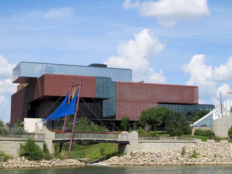
Museum in Saskatoon, Saskatchewan. Remai Modern is a public art museum in Saskatoon, Saskatchewan, Canada. The art museum is situated along the west bank of the South Saskatchewan River, at the River Landing development in Saskatoon's Central Business District. The museum's 11,582 square metres building was designed by Bruce Kuwabara of KPMB Architects in association with Architecture49.
Plans to create a new art museum in Saskatoon emerged after plans to renovate the Mendel Art Gallery were abandoned in 2009. The new art museum was formally incorporated on 9 July 2009 as the Art Gallery of Saskatchewan. In 2016, the institution was rebranded as Remai Modern by the Saskatoon City Council; after Saskatoon-based entrepreneur and philanthropist Ellen Remai announced a donation of CA$30 million on behalf of the Frank and Ellen Remai Foundation to fund the construction and programming for the museum. Construction for the art museum took place from June 2013 to 2017, and was opened to the public in October 2017.
The museum's permanent collection features over 8,000 works from Canadian and international artists. Its collection includes the collection of the former Mendel Art Gallery; and a collection of more than 400 linocuts and ceramics by Pablo Picasso. In addition to exhibiting works from its collection, the museum organizes exhibitions and hosts a number of travelling exhibitions.[16]
Address: 102 Spadina Cres East, Saskatoon
Circle Drive Bridge
Bridge in Saskatoon, Saskatchewan. Circle Drive Bridge spans the South Saskatchewan River in Saskatoon, Saskatchewan, Canada. It is a steel girder bridge, built in 1983 as part of the Circle Drive freeway system in northeast Saskatoon. At the time of construction, it cost $11.8 million to build. Between its opening in 1983 and the opening of the Chief Mistawasis Bridge in 2018, it was the northernmost vehicular river crossing in the city.
As with other bridges in the city, locals use several different names for this bridge. During construction there was an unsuccessful campaign to have it named after recently deceased former Prime Minister John Diefenbaker (despite the politician already having a road, a park, a museum and a memorialized street corner named after him). Longtime Saskatonians also refer to it as the 42nd Street Bridge, a reference to a former name of the northern east-west leg of Circle Drive dating back to the 1960s; this name was also commonly applied to the bridge in media coverage and city council references to its planning and construction dating back to the early 1960s. For a brief time in the mid-2010s, it was referred to informally as the Circle Drive North Bridge to differentiate it from the formally-named Circle Drive South Bridge constructed at the opposite end of the city, until the latter bridge was officially renamed the Gordie Howe Bridge.
The Circle Drive Bridge is a twin-span bridge; it was designed so that more lanes could be added by filling in the centre. Early published plans for the bridge called for the addition of an observation deck/interpretive centre to the underside of the bridge at that point. However, rather than widening the bridge by filling in the centre gap, it was deemed to be more cost effective to convert the outside pedestrian walkways into driving lanes. In 2006, construction started on adding a third outside lane in both directions to increase capacity and ease congestion during peak traffic times. The lane additions were completed in 2007. A new pedestrian walkway was built below and between the two bridge structures, and opened in July 2007. The walkway was dedicated as the Stew Uzelman Pedway on October 31, 2009.
The bridge was the scene of a notable accident on 30 December 2013, when Breanna Pegg lost control of her car after hitting ice on the bridge. Her car went over built-up snow along the guard rail, which launched the vehicle up and over the side of the bridge. It crashed onto the frozen river below and started to sink through the broken ice. Pegg escaped the vehicle by kicking out the windshield, standing on top of the car and swimming to a nearby sheet of ice. She then pulled herself onto the ice before being assisted by police and a bystander. As a result of the accident, the city changed its policy regarding snow removal from bridges. The city was sued by Saskatchewan Government Insurance for the cost of the vehicle and its salvage.[17]
St. Paul's Cathedral
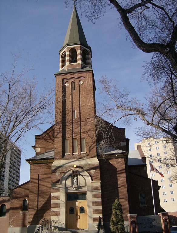
Co-cathedral in Saskatoon, Saskatchewan. St. Paul's Co-Cathedral is a parish of the Roman Catholic Church in Saskatoon, Saskatchewan, Canada, and mother church and co-cathedral of the Diocese of Saskatoon.
The Co-Cathedral is located in the city's Central Business District at the corner of 22nd Street East and Spadina Crescent, on the west bank of the South Saskatchewan River. The cornerstone of St. Paul's was laid on July 25, 1910, by Canadian Prime Minister Sir Wilfrid Laurier and a year later it was formally consecrated by Archbishop Adelard Langevin of St. Boniface, Manitoba. Originally built as parish church, it became a pro-cathedral in 1921, and elevated to a full cathedral in 1934 when the Diocese of Saskatoon was established. The Casavant organ was installed in 1912.
The Institute for Stained Glass in Canada has documented the stained glass at St Paul's Cathedral. The stained glass was added in 1945 to commemorate those who lost their lives in World War II and in 1976 for those that lost their lives to a fire.
Due to its small size and lack of space to expand, the building had been unable to effectively function as a cathedral since the mid-1990s. On December 18, 2011, the new Holy Family Cathedral was opened, and St. Paul's became a co-cathedral and continued to function as a local parish.
In 2019, two paintings of Sts. Peter and Paul by German religious artist Berthold Imhoff were acquired from the church of St. Andrew's in Blaine Lake, which was being decommissioned. Unveiled on June 29, the feast of Sts. Peter and Paul, they remain on display in the sanctuary.[18]
Address: 720 Spadina Crescent E, S7K 3H2 Saskatoon
Chief Mistawasis Bridge
Bridge in Saskatoon, Saskatchewan. The Chief Mistawasis Bridge is a girder bridge in Saskatoon, Saskatchewan. The bridge officially opened on Oct. 2, 2018, and extends McOrmond Drive across the South Saskatchewan River to connect to Marquis Drive, providing a commuter bypass connecting communities on Saskatoon's northeast and eastern sides more directly to industrial and business development on the city's north. Construction of this bridge, located in the northern portion of the city, was financed in concert with construction of replacement for the 1907 Traffic Bridge in the downtown core, which was closed in 2010; that project was opened to traffic on October 3, 2018.
In July 2016 officials announced that, when the bridge was complete, it would be given a name tied to Canada's indigenous peoples. The bridge was officially named the Chief Mistawasis Bridge, in honour of Mistawasis, the head of the Prairie Tribe and signer of Treaty 6 in 1876, at a ceremony on June 21, 2018.
In March of 2017 CBC News described how a berm constructed in the river bed, to channel water around where the bridge's piers were being built was providing an opportunity for urban surfers. Officials warned thrill-seekers that construction made the water near the bridge extra hazardous.
With its bridge-deck 21.6 metres (71 ft) above the river, it is Saskatoon's second highest bridge.[19]
Gordie Howe Bridge

Girder bridge in Saskatoon, Saskatchewan. The Gordie Howe Bridge is a vehicular freeway bridge that spans the South Saskatchewan River in Saskatoon, Saskatchewan, Canada. It is a steel girder bridge, built as part of the Circle Drive freeway system in southwestern Saskatoon. At the time of construction, it was projected to cost $272.5 million to build. It is the southernmost road bridge in the city. The bridge is located adjacent to the Grand Trunk Bridge. It is also the longest of Saskatoon's bridges at 440 metres in length, and the first to have a concrete road surface. The bridge was scheduled to open with the completion of the entire Circle Drive South project on September 30, 2012. However, record rainfall, high water tables and an early snowfall made that deadline unfeasible. The actual completion and opening date was July 31, 2013.[20]
Knox United Church
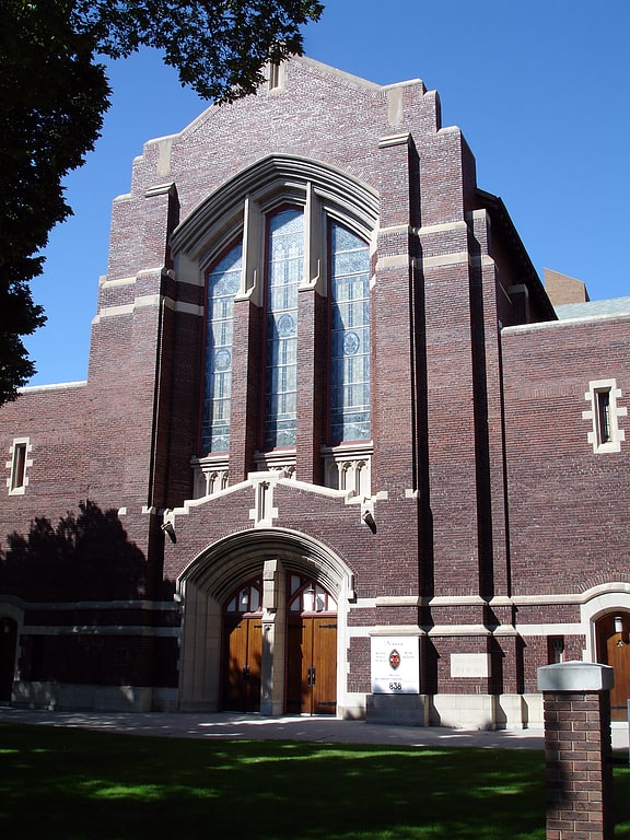
United church of canada in Saskatoon, Saskatchewan. Knox United Church is a designated municipal heritage building at 838 Spadina Crescent East, in the Central Business District, of Saskatoon, Saskatchewan, Canada.
The congregation was established as part of the Saskatoon Presbyterian Field Mission in 1885 after the North-West Rebellion. Meetings were held in homes, the Old Stone Schoolhouse, the Methodist Church and even the railway roundhouse until a wood church holding 160 was constructed near the river.
Architects Brown and Vallance of Montreal designed the present-day church in the Collegiate Gothic style. Construction started in 1912 and was completed in 1914. The two-storey building is made of dark red brick walls, features stained-glass windows, and has seating 1,200. The acoustic qualities of the church have made it a regular venue for various social and cultural events, including chamber music performances. The Institute for stained glass in Canada has documented the stained glass at Knox United Church[21]
Address: 838 Spadina Crescent E, S7K 3H4 Saskatoon
Roxy Theatre
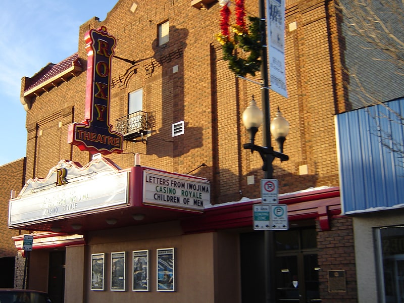
Theatre. The Roxy Theatre is a movie theatre located in the Riversdale neighborhood of Saskatoon, Saskatchewan, Canada, built during the onset of the Great Depression.
The interior was decorated in a Spanish Villa style with the walls covered with small balconies, windows and towers that gave the impression of a quaint Spanish village. The ceiling was painted in an atmospheric-style (dark blue and had twinkling lights set in the plaster) to give the impression of the night sky. The Roxy was built for sound pictures ("talkies") and was the first building in Saskatoon with air conditioning. The New York Roxy, largest cinema ever built in North America (demolished 1960) named after its manager noted radio personality and impresario "Roxy" Rothafel, spawned hundreds of unrelated theatres across North America named Roxy, since the word came to mean the latest and best in showmanship. Rothstein Theatres, who built the Roxy in Saskatoon, used the name in many of their locations. It is one of the last atmospheric cinemas remaining in Canada.[22]
Address: 320 20th St W, S7M 0X2 Saskatoon
Albert Community Centre
Auditorium in Saskatoon, Saskatchewan. The Albert Community Centre is a designated Municipal Heritage Property located in the Varsity View, neighborhood of Saskatoon, Saskatchewan, Canada. Originally built as the Albert School, the 2+1⁄2-storey brick building served as a public school until 1978 when the building was sold to the city and became the Albert Community Centre. The school was originally named for Prince Albert, Queen Victoria's Consort. The most noticeable feature of the building include limestone trim, crenellated tower, crossed mullioned windows, dormers and curved parapet gables.[23]
Traffic Bridge
Truss bridge in Saskatoon, Saskatchewan. The Traffic Bridge is the name given to two truss bridges constructed across the South Saskatchewan River, connecting Victoria Avenue to 3rd Avenue South and Spadina Crescent in Saskatoon, Saskatchewan, Canada. The original bridge opened on October 10, 1907 and was the first bridge to carry motor vehicle traffic in Saskatoon, replacing an unreliable ferry service. The promised construction of the bridge was considered a prime factor in the amalgamation of the towns of Saskatoon, Nutana and Riversdale into one city named Saskatoon. The Traffic Bridge was the only road bridge in Saskatoon until 1916, when the University Bridge was completed. In 2010, the bridge was permanently closed due to severe corrosion and was demolished by 2016.
A new truss bridge, a near-replica of the original except with fewer steel spans and a wider road bed, was constructed on the same site after the original bridge was closed. It opened on October 3, 2018.[24]
Diefenbaker Management Area
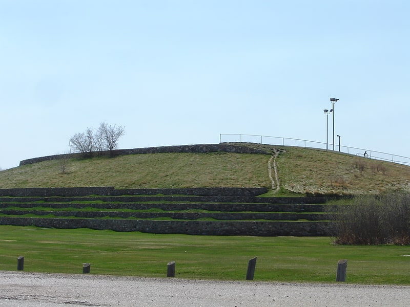
The Diefenbaker Management Area is an area of Saskatoon, to the west of the Exhibition subdivision. The area includes Diefenbaker Park and the Nutana Pioneer Cemetery. The park includes a medium-sized hill which is used for tobogganing and snowboarding, and the park itself is a frequently-used venue for picnics and public events and performances.[25]
Memorial Gates
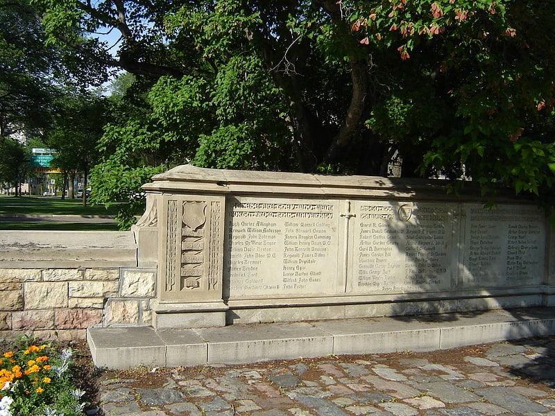
Memorial Gates are a military memorial which are part of the University of Saskatchewan, City of Saskatoon, Saskatchewan. These Gates were originally the entrance gates to the university campus and flanked University Drive. In the 1980s, due to increased traffic to the southwest portion of the campus, primarily Royal University Hospital, a new road entrance was built to the west. The gates remain, with the remnant of University Drive passing through them renamed Memorial Crescent. The gates are now primarily used by pedestrians, though the roadway is open to vehicles.[26]
Prairieland Park
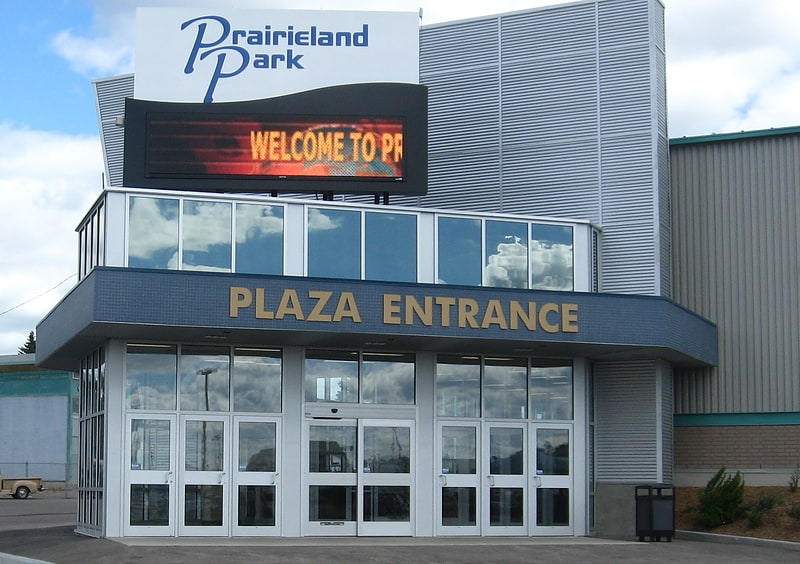
Event venue in Saskatoon, Saskatchewan. Prairieland Park is an events centre in the south-eastern portion of Saskatoon, Saskatchewan. The park is located in the Exhibition neighbourhood of Saskatoon. Each year the park hosts an annual Saskatoon Exhibition called "The Ex". During the remainder of the year most of the park venues are rented out to special events. Some events held are Western Canadian Crop Production Show, Saskatchewan indemand trade show, Saskatoon Fall Fair cattle show and sale, Pet Expo, Chuckwagon Racing, and the Prairieland Junior Ag Showcase.
The Agriculture Department is heavily involved in the community host 4H events.
It currently hosts 321 events a year, which attracts 1.6 million people.[27]
Address: 503 Ruth St W, Saskatoon (Nutana)
Cathedral of St. George
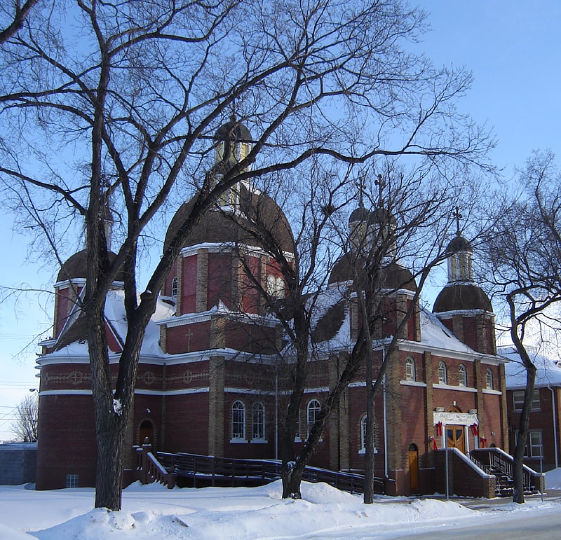
Catholic cathedral in Saskatoon, Saskatchewan. The Ukrainian Catholic Cathedral of St. George was designed by architect the Very Reverend Philip Ruh, O.M.I. in 1923. It is located in Pleasant Hill, Core Neighbourhoods SDA, Saskatoon, Saskatchewan, Canada and is the Episcopal See of the Bishop of the Saskatoon Eparchy.[28]
Address: 214M S, S7M 2K4 Saskatoon
Paddock Wood Brewing Co.
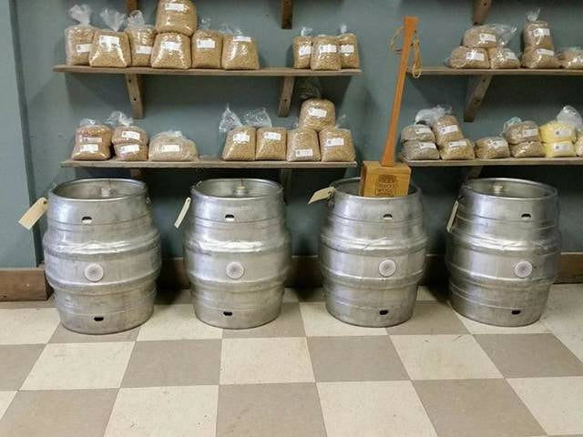
Brewery, Eat and drink, Nightlife, Drinks
Address: B1 - 116 103rd St E, Saskatoon (University Heights)
Remai Arts Centre
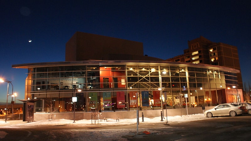
Theatre in Saskatoon, Saskatchewan. Frank & Ellen Remai Arts Centre is a performing arts centre in the River Landing area of Saskatoon, Saskatchewan, Canada. The centre is owned by and the main venue for the Persephone Theatre. Constructed in 2007 at a cost of $11 Million Canadian, the main theatre seats 450, with a second smaller 100-seat theatre and other supporting facilities and workshops that make up the centre.
The Remai Modern art gallery is adjacent and connected to the Remai Arts Centre. Both facilities share an underground parking garage.[29]
Address: 100 Spadina Crescent, Saskatoon
Civic Conservatory
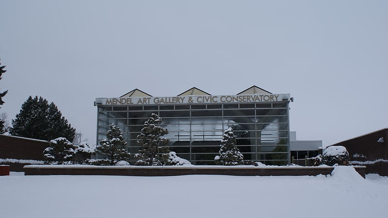
Art gallery in Saskatoon, Saskatchewan. The Mendel Art Gallery was a major creative cultural centre in City Park, Saskatoon, Saskatchewan. Operating from 1964 to 2015, it housed a permanent collection of more than 7,500 works of art. The gallery was managed by the city-owned Saskatoon Gallery and Conservatory Corporation, which also managed the Mendel's sister institution, the Saskatoon Civic Conservatory. In 1999, it was the 16th largest public art gallery in Canada by budget size and had the sixth highest overall attendance in the country. By 2010, it had more than 180,000 visitors.
Plans to expand the Mendel Art Gallery began in the 2000s, although they were later abandoned by the City of Saskatoon government in favour of establishing a new art museum. The Mendel Art Gallery was closed on 7 June 2015, with its assets divided between the City of Saskatoon government and the new art museum. The permanent collection of the Mendel Art Gallery was transferred to the new art museum, the Remai Modern, after its opening in October 2017.[30]
Address: 950 Spadina Cres E, S7K 3H6 Saskatoon
Senator Sid Buckwold Bridge
Bridge in Saskatoon, Saskatchewan. The Senator Sid Buckwold Bridge is a bridge that spans the South Saskatchewan River between west and east shore in Saskatoon, Saskatchewan, Canada. It was built in 1966, on the same site as the original Qu'Appelle, Long Lake and Saskatchewan bridge. The bridge is part of the Idylwyld Freeway, for which the former CNR Bridge was torn down. The act of dynamiting the original piers of the CNR Bridge became something of a spectacle as demolition experts were unable to completely destroy them. At the time, the new bridge cost $1.5 million to build.
Construction of the bridge was one of several simultaneous, interconnected major projects that occurred in Saskatoon during the mid-to-late 1960s. Related projects included: the construction of the Midtown Plaza shopping centre and CN Towers office block which followed the demolition of the former CNR Station and the removal of the attending railyard and CNR Bridge; construction of the Saskatoon Centennial Auditorium (now called TCU Place) also on former railway land; and construction of the Idylwyld Freeway itself from 20th Street southwards to just south of Ruth Street where it joined with another late-1960s freeway project, the south east leg of Circle Drive.
Also known by its former name, the Idylwyld Bridge and, by locals, as the Freeway Bridge, the structure was renamed in honor of former mayor and senator Sidney Buckwold in 2001, following Buckwold's death. Buckwold served two non-consecutive terms as mayor between 1958 and 1971, the period of time in which the bridge planning and construction and the nearby inner-city redevelopment took place.
When a major rehabilitation project began on the bridge in 2019, crews discovered that approximately 350 tons of pigeon droppings were stuck to the structure. In addition to removing the droppings, the contractor was ordered to trap and humanely euthanize the 1500 pigeons roosting on the bridge. The plan to euthanize the birds drew criticism from wildlife advocates, and the city later stopped the use of 4-Aminopyridine for pest control. The construction project was completed in September 2020; the work done included repairing and resurfacing the bridge deck, and widening the pedestrian walkways.[31]
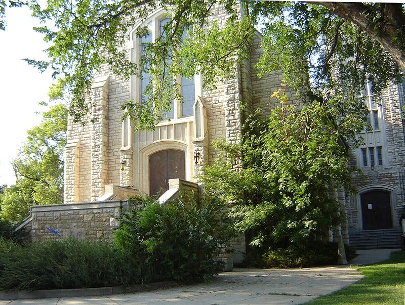
Holy Family Cathedral
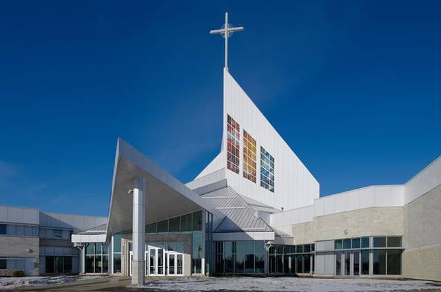
Cathedral in Saskatoon, Saskatchewan. The Cathedral of the Holy Family is a Roman Catholic cathedral in the University Heights Suburban Centre neighbourhood of Saskatoon, Saskatchewan, Canada. The Cathedral is located on land adjacent to St. Joseph High School.
St. Paul's Cathedral had reached its physical limits, which necessitated the Roman Catholic Diocese of Saskatoon to build the Cathedral of the Holy Family. Construction on the CAD$28.5 million 65,000 sq ft (6,000 m2) cathedral started in 2010. and it opened on December 18, 2011.
The main worship space seats 1,200 with provision to use an overflow area bringing the total to 2,000. The building serves as a parish church, diocesan cathedral, private residence, meeting space, office building, library, archive storage, banquet hall and community centre. The building is designed in an anachronistic modernist style, which is not particularly contemporary, but seems to exemplify a late 1950s-60s attitude towards the future.
Some of the cathedral stained glass windows are equipped with solar panels. This makes the church the first in North America to make use of photovoltaic cells in a stained glass installation. The installation makes use of 1,000 solar cells embedded in 54 panels.[32]
Address: 123 Nelson Rd, S7S 1H1 Saskatoon (University Heights)
Canada Building
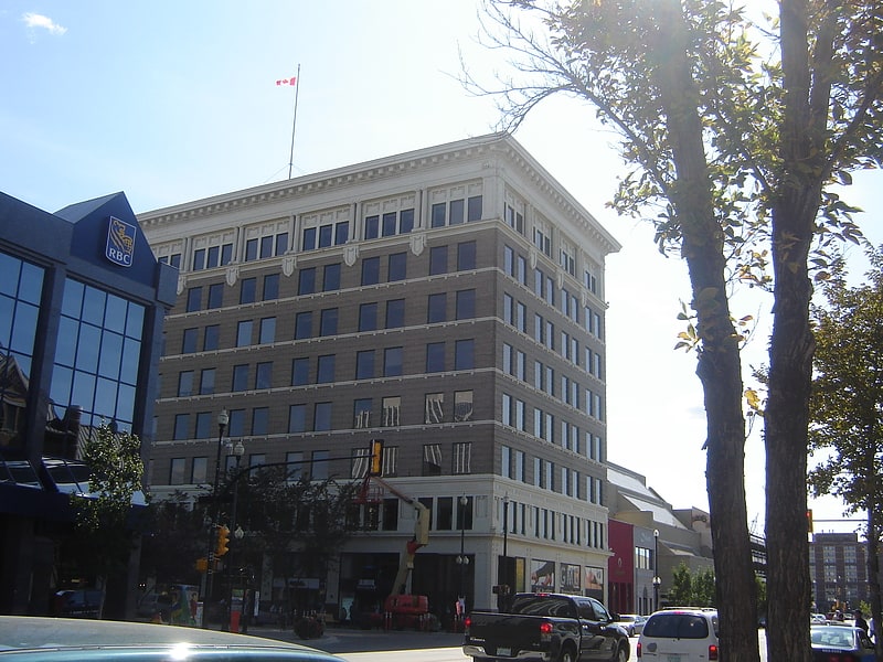
Building in Saskatoon, Saskatchewan. The Canada Building is a historic eight-story office block in the Central Business District of Saskatoon, Saskatchewan, Canada. The building is 35.05 m in height featuring red granite facing on the base, with terra cotta details on the lower two floors and cornice near the roof. The office building features large bison heads flanking the main doorway.
The office building was built by Allan Bowerman. Bowerman was also responsible for the development of the Bowerman House.[33]
Address: 21st Street East, Saskatoon
St. Thomas More College
Liberal arts college in Saskatoon, Saskatchewan. St. Thomas More College is a Catholic, undergraduate, liberal arts college located in Saskatoon, Saskatchewan, Canada, and is a federated college of the University of Saskatchewan.[34]
Address: 1437 College Dr, S7N 0W6 Saskatoon (University Heights)