Discover 15 hidden attractions, cool sights, and unusual things to do in Plymouth (United Kingdom). Don't miss out on these must-see attractions: Mount Edgcumbe House, Dartmoor Zoological Park, and Mutley Baptist Church. Also, be sure to include Tamar Bridge in your itinerary.
Below, you can find the list of the most amazing places you should visit in Plymouth (England).
Table of Contents
Mount Edgcumbe House
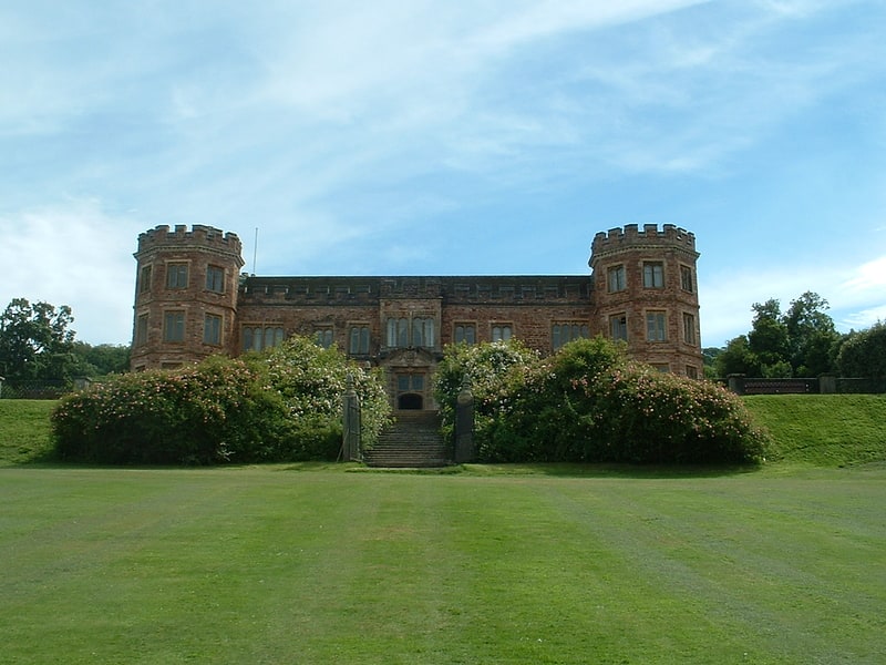
Building in England. Mount Edgcumbe House is a stately home in south-east Cornwall and is a Grade II listed building, whilst its gardens and parkland are listed as Grade I in the Register of Parks and Gardens of Special Historic Interest in England.
Mount Edgcumbe Country Park is situated in the parish of Maker on the Rame Peninsula, overlooking Plymouth Sound; its main entrance is in the village of Cremyll.
It was the principal seat of the Edgcumbe family since Tudor times, many of whom served as MP before Richard Edgcumbe was raised to the peerage as Baron Edgcumbe in 1742. His 2nd son, George, was advanced to the rank of Earl in 1789.[1]
Address: Mount Edgcumbe House, PL10 1HZ Plymouth
Dartmoor Zoological Park

Zoo in England. Dartmoor Zoological Park is a 30-acre zoo just north of the village of Sparkwell, on the south-west edge of Dartmoor, in the county of Devon in the South West of England. It was opened in 1968 by Ellis Daw who ran it until its licence was revoked and it was forced to close in 2006. The zoo was bought in August 2006 by Benjamin Mee, who reopened the zoo in July 2007, later writing a book about his experiences called We Bought a Zoo. A 2011 film of the same title was loosely based on the book.[2]
Mutley Baptist Church
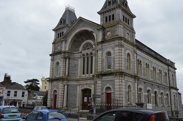
Baptist church in Plymouth, England. Mutley Baptist Church is an evangelical Baptist church and congregation in Mutley Plain, Plymouth, Devon, situated in a large Grade II building, designed by architect J. Ambrose in 1867.[3]
Tamar Bridge
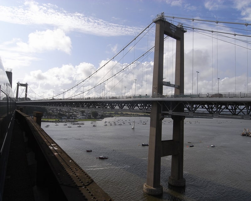
Suspension bridge in Saltash, United Kingdom. The Tamar Bridge is a suspension bridge over the River Tamar between Saltash, Cornwall and Plymouth, Devon in southwest England. It is 335 metres long, running adjacent to the Royal Albert Bridge, and part of the A38, a main road between the two counties.
During the 20th century, there was increasing demand to replace or supplement the Saltash and Torpoint ferries, which could not cope with the rise in motor traffic. The Government refused to prioritise the project, so it was financed by Plymouth City Council and Cornwall County Council. Construction was undertaken by the Cleveland Bridge & Engineering Company and began in 1959. It was unofficially opened in October 1961, with a formal presentation by Queen Elizabeth The Queen Mother in April 1962. A reconstruction of the bridge began in 1999 after it was found to be unable to support a European Union requirement for goods vehicle weights. The work involved building two new parallel decks while the original construction was completely rebuilt. The project was completed in late 2001 and formally opened by Princess Anne in April 2002. The extra decks have remained in use, increasing the bridge's capacity.
The bridge is tolled for eastbound travel, with a discount available via an electronic payment scheme. It has become a significant landmark in Plymouth, Saltash and the surrounding area, and used on several occasions for protests or to highlight the work of charities and fundraisers.[4]
Plymouth Breakwater
Plymouth Breakwater is a 1,560-metre stone breakwater protecting Plymouth Sound and the anchorages near Plymouth, Devon, England. It is 13 metres wide at the top and the base is 65 metres. It lies in about 10 metres of water. Around 4 million tons of rock were used in its construction in 1812 at the then-colossal cost of £1.5 million.[5]
The Plymouth Athenaeum
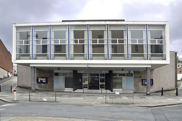
Plymouth Athenaeum, located in Plymouth, England, is a society dedicated to the promotion of learning in the fields of science, technology, literature and art.
The Athenaeum building, located at Derry's Cross in Plymouth City Centre, includes a 340-seat auditorium and a local interest library.[6]
Staddon Fort
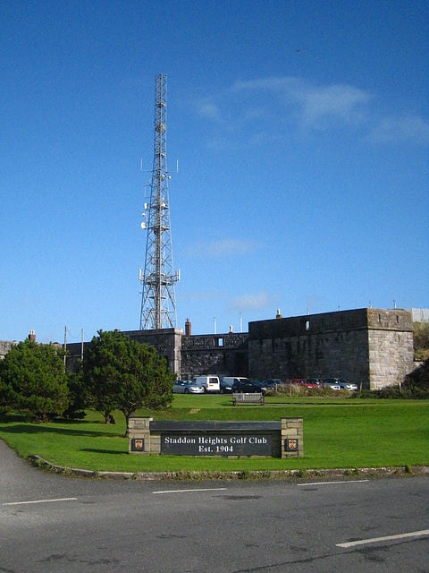
Staddon Fort is a 19th-century fort, built as a result of the Royal Commission on National Defence of 1859. Part of an extensive scheme known as Palmerston Forts, after the prime minister who championed the scheme, it was built to defend the landward approaches to the east of Plymouth, as an element of the plan for the defence of the Royal Naval Dockyard at Devonport.
Designed by Captain (later Maj General) Edmund Frederick Du Cane, it was built by George Roach and Company. The fort was connected by a military road to the nearby Stamford Fort, Watch House Battery and Brownhill Battery. It was designed to be armed with 34 guns and 6 mortars. To house the fort's garrison a barrack block for 250 men was built within the rear section of the fort.
By the early 1900s the fort had become obsolete as a defensive position and was disarmed. It remains in use by the Royal Navy as a communications centre. Along with a number of other parts of the Staddon Heights defences, it became a scheduled monument in 1969.[7]
Stoke Damerel Church
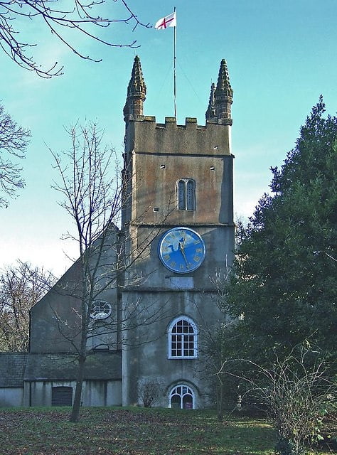
Anglican church in Plymouth, England. Stoke Damerel Church, also known as the Church of St Andrew with St Luke, is a Church of England church in Stoke, Plymouth, Devon, England. Dating from the 15th century, the church has been Grade II* listed since 1954. In addition to its listed status, the northern churchyard gate piers are also Grade II listed, alongside two 19th-century tombs, one of which belongs to Captain Tobias Furneaux.[8]
Fort Bovisand
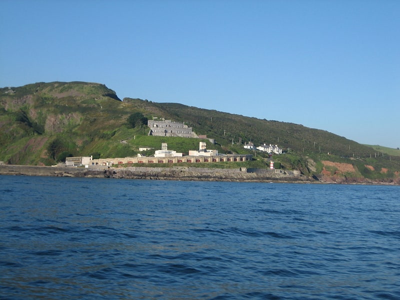
Historical landmark in England. Fort Bovisand is a fort in Devon, England near the beach of Bovisand. It was built as a result of the Royal Commission on the Defence of the United Kingdom which reported in 1860. It is located on the mainland to defend the entrance of Plymouth Sound, at the narrows opposite the east end of Plymouth Breakwater. The fort is beside Bovisand harbour.[9]
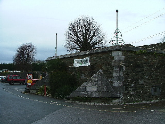
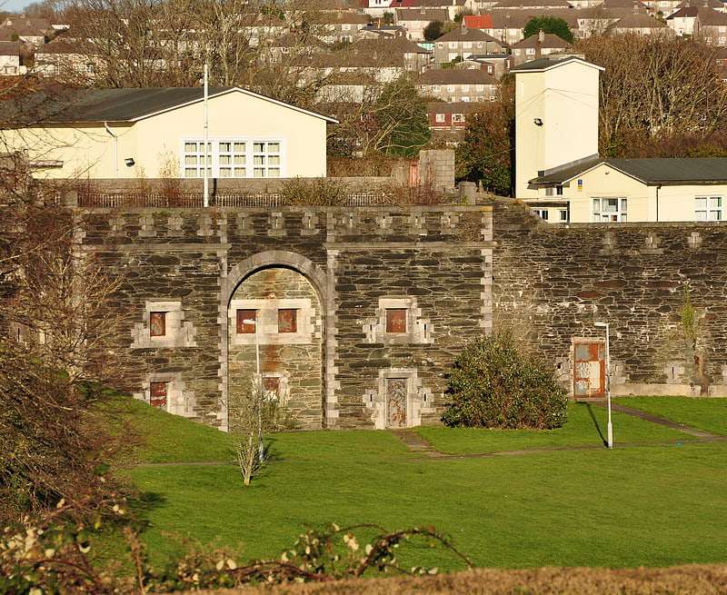
Fort Austin
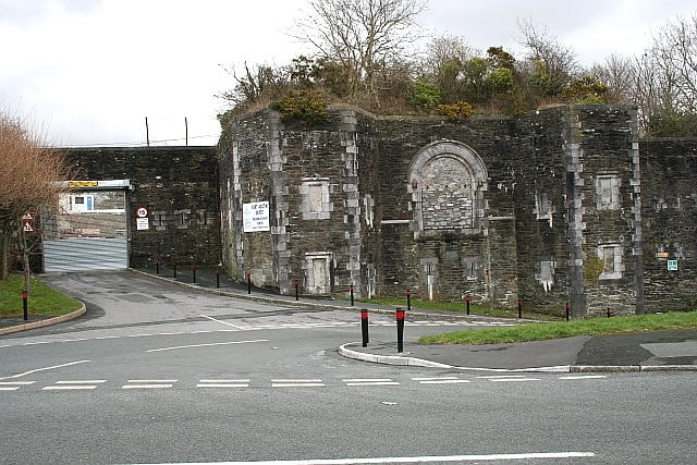
Fort Austin is a former 19th-century Fort, built as a result of the Royal Commission on National Defence of 1859. It was built to defend the landward approaches to the North East of Plymouth. This was part of an overall scheme for the defence of the Royal Naval Dockyard at Devonport. They were known as Palmerston Forts after the Prime Minister who championed the scheme.
Designed by Captain (later Maj General) Edmund Frederick Du Cane, it was built by George Baker and Company and finished by the Royal Engineers. It was armed with fifteen guns and five mortars. To house part of the Forts' Garrison a barrack block to house 60 men was built within the rear section of the Fort.
By the early 1900s the Fort had become obsolete as a defensive position and was disarmed. During the Second World War it was used by the Devon and Cornwall Auxiliary Unit. It was sold by the War Office to Plymouth City Council in 1958. It was Grade II listed in 2008. It is now used as a Depot for Plymouth City Council.[10]
Bowden Fort
Bowden Fort is a former 19th-century fort, built as a result of the Royal Commission on National Defence of 1859. Part of an extensive scheme known as Palmerston Forts, after the prime minister who championed the scheme, it was built to defend the landward approaches to the north east of Plymouth, as an element of the plan for the defence of the Royal Naval Dockyard at Devonport.
Designed by Captain (later Maj General) Edmund Frederick Du Cane, it was built by George Baker and Company and finished by the Royal Engineers. The fort was connected by a military road to the nearby Crownhill Fort and Forder Battery. It was armed with 12 guns and 3 mortars. To house part of the fort's garrison a barrack block for 12 men was built within the rear section of the fort.
By the early 1900s the fort had become obsolete as a defensive position and was disarmed. By 1960 it had been sold by the War Office to Plymouth City Council. It was Grade II listed in 1973. It is now used as a garden centre. The rear gorge has been filled in and now provides car parking.[11]
Knowles Battery
Knowles Battery is a former 19th-century fort, built as a result of the Royal Commission on National Defence of 1859. Part of an extensive scheme known as Palmerston Forts, after the prime minister who championed the scheme, it was built to defend the landward approaches to the north east of Plymouth, as an element of the plan for the defence of the Royal Naval Dockyard at Devonport.
Designed by Captain (later Maj General) Edmund Frederick Du Cane, it was built by George Baker and Company and finished by the Royal Engineers. It was designed to be armed with thirteen guns. Fire from the battery linked with nearby Woodlands Fort and Agaton Fort
By the early 1900s the fort had become obsolete as a defensive position and was disarmed. It was sold by the War Department in 1930. A school was built on the site in the 1960s. Knowles Battery was Grade II listed in 1973. It is now part of Knowle Primary School.[12]
Cremyll School and Chapel
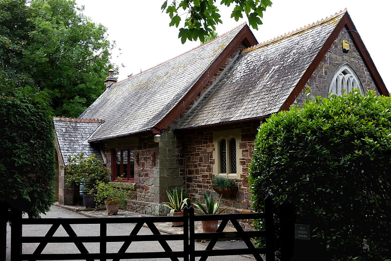
Cremyll School and Chapel is a former schoolroom and chapel in Cremyll, Cornwall, England. It was erected in 1867 and is now a private residence, known as the Old School Rooms.[13]
Western King's Redoubt
The Western King's Redoubt is an 18th and 19th-century artillery battery in Plymouth, Devonshire, England, upgraded as a result of the Royal Commission on the Defence of the United Kingdom of 1859. Part of an extensive scheme known as Palmerston Forts, after the prime minister who championed the scheme, it was built to defend the seaward approaches to the Hamoaze, as an element of the plan for the defence of the Royal Naval Dockyard at Devonport.
In 1779, a pair of small forts or redoubts were constructed overlooking Firestone Bay in Plymouth Sound, known as Western and Eastern King's Redoubts. The western redoubt mounted twelve 18-pounder cannons. In 1861, a battery was built to mount nine guns, with a further seven guns in the older redoubt to the rear of the battery. By 1893 it mounted nine 64 Pounder Rifled Muzzle Loading Guns.
By 1897 the battery was remodelled and a battery for seven 12 Pounder Quick Firing (QF) guns was built over the west flank and redoubt. By 1918 only four of these guns remained.
In 1941 two positions were created for twin 6 pounder Quick Firing guns to provide rapid firing capability against enemy Motor Torpedo Boats (MTBs). These positions remained armed until the dissolution of coast artillery in 1956 when they were removed.
Today the site is open and can be explored. The 12 Pounder Quick Firing gun positions survive intact and the positions for the twin 6 Pounder guns have been partly filled in but retain their overhead cover, designed as protection against air attack.[14]
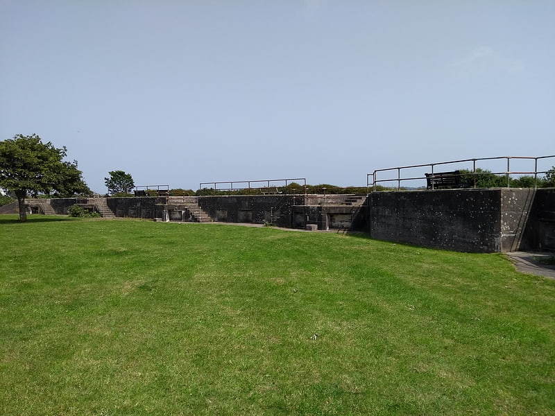
Lord Howard's Battery
Historical landmark in Plymouth, England. Lord Howard's Battery is a former gun battery built in 1908–09 to defend the approach to HMNB Devonport through Plymouth Sound and Jennycliff Bay.
The battery was armed with two BL 6-inch Mk VII guns, which were removed prior to World War II. The battery was recommissioned in 1941 with the installation of two guns of the same type, and these remained in place until the battery's closure in 1946.
After its closure, the battery was used as a caravan site. During the late 20th-century, the battery and its surrounding area was transformed into a public space by Plymouth City Council. The two gun emplacements and magazine were infilled with earth, and all ancillary buildings were demolished. The features that remain visible include the concrete aprons of the emplacements and a concrete parapet. Adjacent to Jennycliff Cafe is the battery's former blockhouse.[15]