Discover 15 hidden attractions, cool sights, and unusual things to do in Oldham (United Kingdom). Don't miss out on these must-see attractions: Alexandra Park, Tandle Hill, and Saddleworth Museum. Also, be sure to include Oldham War Memorial in your itinerary.
Below, you can find the list of the most amazing places you should visit in Oldham (England).
Table of Contents
Alexandra Park
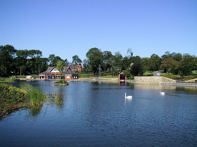
Park in Oldham, England. Alexandra Park is a public park in Oldham, Greater Manchester, England. It was created in response to the Lancashire Cotton Famine of 1861–1865 as an attempt to keep local textile workers employed. The park is located in the Glodwick area of Oldham.
Oldham was hit hard by the Lancashire Cotton Famine of 1861–1865 when supplies of raw cotton from the United States were cut off. Wholly reliant upon the textile processing industry, the economy of Oldham strained as the cotton famine created chronic unemployment in the town. By 1863 a committee had been formed and with a loan from central government, land at Swine Clough was purchased from Reverend John Cocker of Shaw and Crompton whom made it a condition that local unemployed cotton workers were employed to construct the park which opened on 28 August 1865. John Thomas Cocker, Esq. of New-bank Heyside purchased the estate of Swine Clough in 1850 from the Ogden Family. This family enjoyed this estate for several generations. It was sold to Adam Ogden the elder in 1670 by Edmund Assheton, Esq. of Chadderton, Swine Clough was an ancient farm a short distance to the west of Glodwick.
Opened by Josiah M Radcliffe, the then Mayor of Oldham, the park was named to commemorate the marriage of Albert, Prince of Wales to Alexandra of Denmark. During its history it has had a "refreshment room", a boating lake (constructed in 1903) and been the site of statues honouring local Oldhamers of eminence.
A number of structures in the park are grade II listed, including ornamental features, buildings and statues of John Platt and Robert Ascroft.
Oldham council plans to open a state of the art eco-centre at the park sometime in Spring 2022.[1]
Tandle Hill
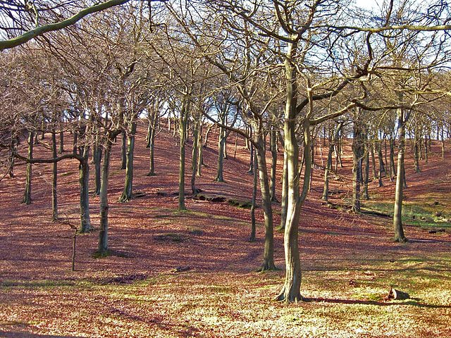
Country park in Royton, England. Tandle Hill Country Park is a country park in Royton, Greater Manchester, England. It consists of approximately 110 acres, a combination of beech woodland and open grassland. The park contains a countryside centre, picnic areas, children's play area and numerous trails and paths into the surrounding area. Two countryside rangers are based at the countryside centre. In fine weather conditions, it offers views of Manchester and the Welsh mountains.[2]
Address: Tandle Hill Road, OL2 5UX Royton, Oldham (Oldham)
Saddleworth Museum
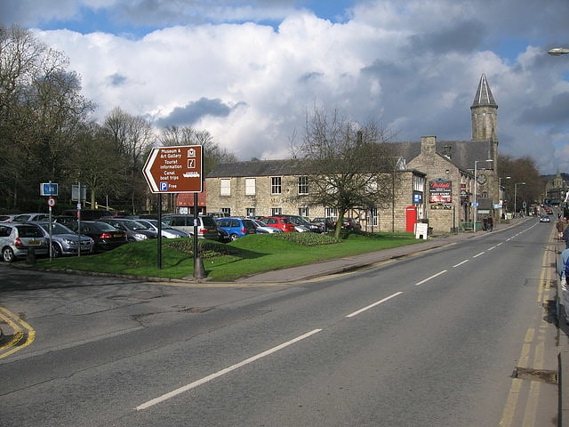
Museum in Uppermill, England. Saddleworth Museum is an independent museum in Uppermill village, Saddleworth, Metropolitan Borough of Oldham, Greater Manchester, England. It is a registered charity and was accredited by the MLA.
The museum opened in 1962 and is housed in the outbuildings of the Victoria Mill, a 19th-century mill building which stood beside the Huddersfield Narrow Canal. Its collections show the history of Saddleworth, which until 1974 local government reorganisation was part of the West Riding of Yorkshire. In September 2015 the museum closed for repair and remedial work to be undertaken and there was a temporary cabin in place while work on the building continued. the museum re-opened a year later in September 2016 after a £1.25 million refurbishment.[3]
Address: High St, OL3 6HS Oldham
Oldham War Memorial
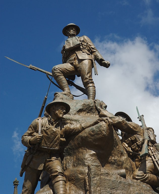
Memorial park in Oldham, England. Oldham War Memorial is a war memorial in Oldham, England, comprising a large bronze sculpture group on a granite plinth. It was built to commemorate the men of Oldham who were killed in the First World War. Bronze plaques on the wall of the churchyard nearby list the fallen, including Mabel Drinkwater, a nurse who died after an operation at Oldham Royal Infirmary. A mechanised roll of honour was added in the 1950s, listing the men from Oldham who were killed in the Second World War. The memorial became a Grade II listed building in 1973. The listing was upgraded to Grade II* in December 2016.[4]
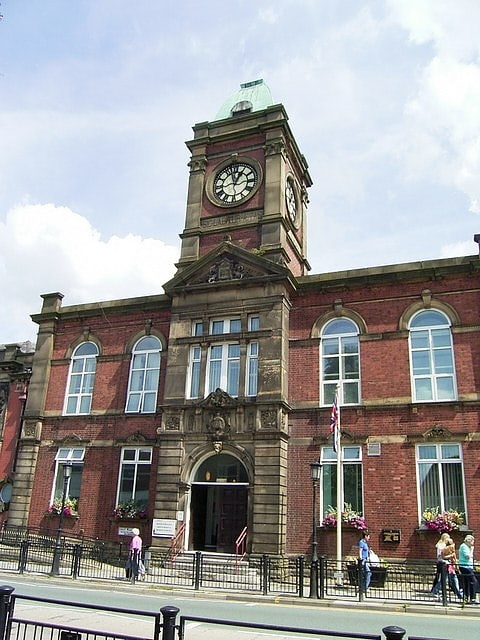
Chadderton Town Hall
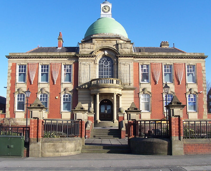
Chadderton Town Hall is a municipal building on Middleton Road, Chadderton, Greater Manchester, England. The town hall, which was the headquarters of Chadderton Urban District Council, is a grade II listed building.[5]
Gallery Oldham
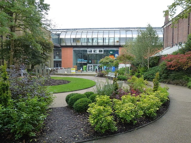
Museum in Oldham, England. Gallery Oldham is a free-to-view public museum and art gallery in the Cultural Quarter of central Oldham, in Greater Manchester, England.[6]
Address: 35 Greaves St, OL1 1TJ Oldham (Oldham)
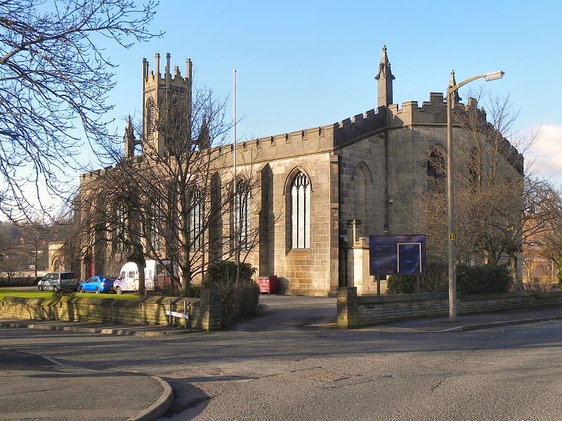
Oldham Parish Church
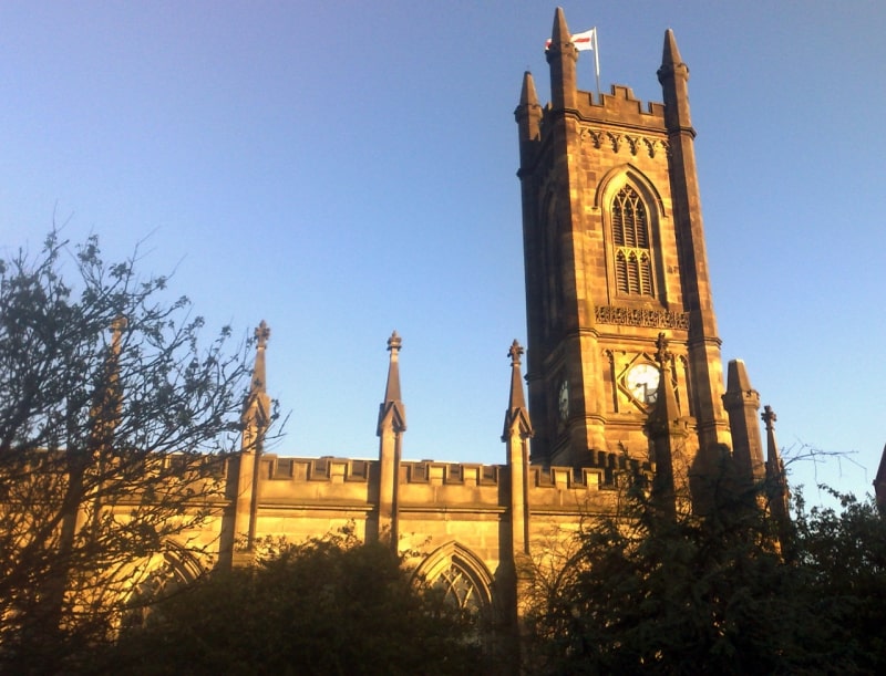
Parish church in Oldham, England. The Church of St. Mary with St. Peter, mostly known as Oldham Parish Church, is the Church of England parish church for Oldham in Greater Manchester, England. It forms part of the Diocese of Manchester, and is one of several Grade II* listed buildings in Greater Manchester.
A church building had existed on the site since 1280. During this time, a small chapel stood on the site to serve the local townships of Oldham, Chadderton, Royton and Crompton. This was later replaced by an Early English Gothic Church in the 15th century. With the coming of the Industrial Revolution, the population of Oldham increased at a rapid rate (from under 2,000 in 1714, to over 32,000 by 1831). The rapid growth of the local population warranted that the building be rebuilt into the current structure. Though the budget was originally agreed at £5,000, the final cost of building was £30,000, one third of which was spent on the crypt structure. Alternative designs by Sir Charles Barry, the designer of the Palace of Westminster, although now regarded by some as superior, were rejected. In 1805 the churchyard was enlarged and nearby Church Lane, Oldham became a cul-de-sac severing an ancient route through the town. The previous continuance of the road (Church Street) was lowered by 6 feet and became an extension of the recently created Church Terrace.
The church its present form, dates from 1830 and was designed in the Gothic Revival Style by Richard Lane, a Manchester-based Architect. It has been designated by English Heritage as a Grade II* listed building. It was linked with St Mary's Church in Prestwich and together the sites were principal churches of the ancient ecclesiastical parish of Prestwich-cum-Oldham.
The peal of twelve bells was cast in 1922 by John Taylor & Co of Loughborough. An additional flat 6th was cast in 1978. The church also retains its original bell, cast in 1722 by Abraham Rudhall II of Gloucester.[7]
Address: Rock St, OL1 3UH Oldham (Oldham)
Chadderton Hall Park
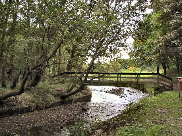
Park in Chadderton, England. Chadderton Hall Park is a park in Chadderton, in the Metropolitan Borough of Oldham, Greater Manchester, England. Its roots stretch back to the 13th century being the land on which Chadderton Hall once stood. It contains a large field area with a small football pitch, a playground area, several flower gardens and a small café situated next to the Park's bowling green. The River Irk runs through the centre of the park.[8]
Royton Town Hall
Royton Town Hall is a municipal building in Rochdale Road, Royton, Greater Manchester, England. The town hall was the headquarters of Royton Urban District Council.[9]
Lees
Village in England. Lees is a village in the Metropolitan Borough of Oldham, Greater Manchester, England, amongst the Pennines east of the River Medlock, 1.8 miles east of Oldham, and 8.2 miles northeast of Manchester.
In the 14th century, when John de Leghes was a retainer of the local Lord of the Manor, Lees was a conglomeration of hamlets, ecclesiastically linked with the township of Ashton-under-Lyne. Farming was the main industry of this rural area, with locals supplementing their incomes by hand-loom weaving in the domestic system. At the beginning of the 19th century, Lees had obtained a reputation for its mineral springs; ambitions to develop a spa town were thwarted by an unplanned process of urbanisation caused by the rise of textile manufacture during the Industrial Revolution.
Lees expanded into a mill town in the late-19th century, on the back of neighbouring Oldham's boom in cotton spinning. Lees Urban District had eleven cotton mills at its manufacturing zenith.[10]
St Patrick's
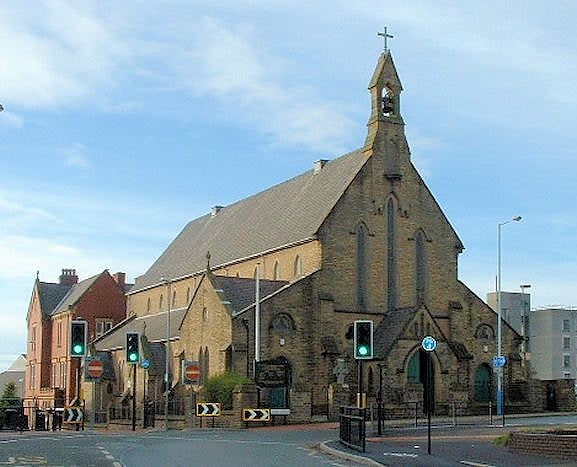
Building. Our Lady of Mount Carmel and St Patrick Church or St Patrick's Church is a Roman Catholic Parish church in Oldham, Greater Manchester, England. It was founded in 1858 and was built in 1870. It is situated on the corner of John Street and Union Street West, north of Oldham Sixth Form College in the centre of the town. It is a Gothic Revival church and is a Grade II listed building.[11]
Address: 40 Union St W, OL8 1DL Oldham (Oldham)
Oldham Civic Centre
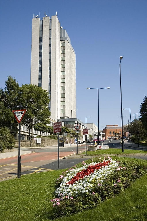
Government office in Oldham, England. Oldham Civic Centre is a municipal building in West Street, Oldham, England.[12]
St James' Church
Church in Oldham, England. St James' Church is in Barry Street, Greenacres Moor, Oldham, Greater Manchester, England. It is an active Anglican parish church in the deanery of Oldham East, the archdeaconry of Rochdale, and the diocese of Manchester. The church is recorded in the National Heritage List for England as a designated Grade II listed building. It was a Commissioners' church, having received a grant towards its construction from the Church Building Commission.[13]
Address: Barry Street, Oldham (Oldham)
St Matthew's Church
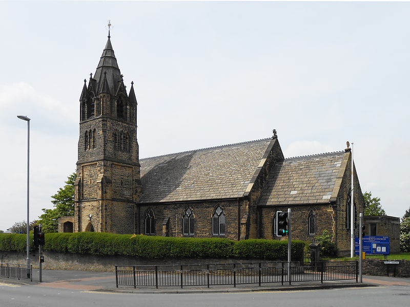
Commissioners' church in Chadderton, England. The Parish Church of St. Matthew is the Church of England parish church for Chadderton in Greater Manchester, England. It forms part of the Diocese of Manchester and is one of several Grade II listed buildings in Greater Manchester.
The Parish of St. Matthew, Chadderton was formed in 1844. Prior to the present building there was a small wooden chapel erected in 1845, to meet the spiritual needs of the parish, whilst the present building was constructed. Work, by E. H. Shellard began in 1847 and the church in its original form was completed and consecrated in 1857. Although the parish at that time was geographically large the number of dwellings was not. However, over the years more housing was built and the parish was divided to form the parishes St. Mark, St. Luke, St. Gabriel, Middleton Junction, St. Anne, Royton and St. Matthew; part of the parish was also annexed to the parish of St. Leonard, Middleton. The current parish has about 2500 dwellings with a population of approximately 7000 souls. Much of the parish is made up of semi-detached housing, with some detached and some terraced. Whilst the area in general can be described as sub-urban, there are pockets of rural land which is farmed, and areas of green-belt. The parish has various ages of housing (most of which is privately owned) some 19th Century, some pre-war and post-war, as well as a 1970s estate and some local authority housing. Around the parish a small retail park and various local shops are located.
The churchyard contains war graves of 14 service personnel of World War I and 9 of World War II.[14]
Address: Chadderton Hall Rd, OL1 2RT Oldham (Oldham)
Strinesdale Reservoir
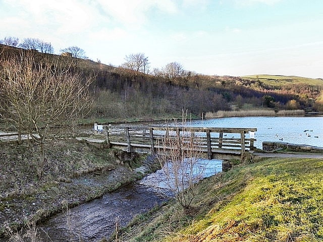
Reservoir in England. Strinesdale is a reservoir situated on the A62 between Oldham and Delph in Greater Manchester, England. The town of Rochdale is to the north and the town of Oldham to the south. It is fed by the River Medlock.
Strinesdale is an area of water and woodland covering approximately 40 acres (162,000 m2). In 1991, the reservoirs were drained and replaced by two smaller lakes with the old reservoir sites being planted with trees and grassland. The original reservoirs were built in 1828 and the erected plaque can be seen at Upper Strinesdale. Herons and kestrels can be seen on the lakeside and as the woodland develops it will provide shelter for animals and birds and many varieties of wild flowers.
Strinesdale derives its name from the Old English "Strine" meaning boundary in connotation to the old Lancashire/Yorkshire boundary that ran through the middle of the site; since 1974 the whole area lies in Greater Manchester.
Strinesdale WAS home to a children's boarding hospital in the 1950s - 1960s[15]