Discover 15 hidden attractions, cool sights, and unusual things to do in Tealham and Tadham Moors (United Kingdom). Don't miss out on these must-see attractions: Church of St Mary, Somerton Viaduct, and Church of St Mary. Also, be sure to include Church of St Saviour in your itinerary.
Below, you can find the list of the most amazing places you should visit in Tealham and Tadham Moors (England).
Table of Contents
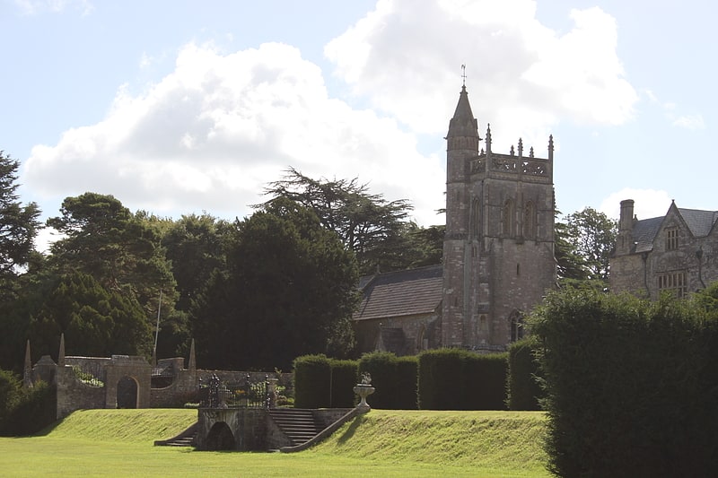
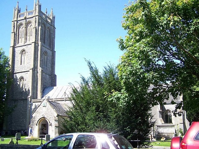
Church of St Mary
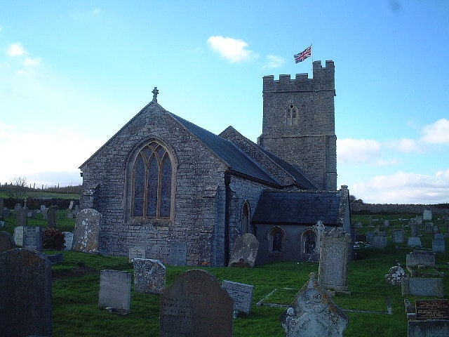
Building in Berrow, England. The Church of St Mary in Berrow, Somerset, England dates from the 13th century and was restored in the 19th. It has been designated as a grade I listed building.
The church is built of limestone from the Mendip Hills with Hamstone for the decoration. The south aisle is from the 15th century but was remodeled during the Victorian era.
The two-stage tower, which dates from the 15th century, contains a bell dating from 1801 and made by Thomas and James Bilbie of the Bilbie family, along with four other bells. It can be seen from the sea and was once painted white to act as a lighthouse.
The interior includes 14th and 15th century fonts.
The Anglican parish is part of the Berrow and Brean benefice within the archdeaconry of Wells.[1]
Somerton Viaduct
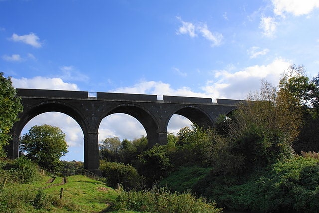
Viaduct in England. The Somerton Viaduct is a historic railway viaduct in the town of Somerton in Somerset, England. It is situated on the Langport and Castle Cary Railway, known as the Castle Cary Cut-off, on the Reading to Taunton Line. It carries the railway over the River Cary.
The viaduct was opened in 1906. The construction was overseen by Great Western Railway engineer P.A. Anthony.[2]
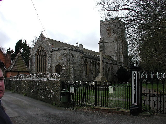
Church of St Mary
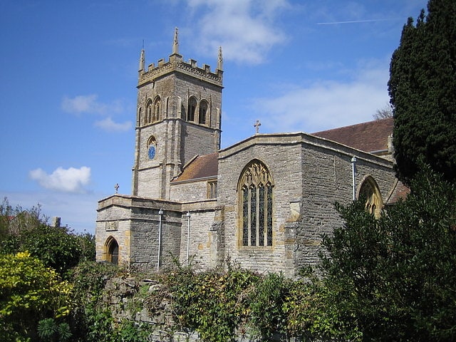
Building in England. The Anglican Church of St Mary in Chedzoy, Somerset, England dates from the 13th century and has been designated as a grade I listed building.
There is evidence of a Church in Chedzoy in 1166 when it was given along with the parent church in North Petherton to Buckland Priory. The tower dates from the early 16th century when the porch, clerestory, the arch into the north transept, and the windows in the north aisle were added.
Much of the current building is from the 17th century, although the Norman chancel, chancel arch and doorway remain. It was extensively remodelled by William Butterfield in 1861. A late medieval screen and rood loft were removed around 1841. The font has survived since the 13th century. The pulpit is from the 16th century. Amongst the memorials is a brass believed to commemorate Richard Sydenham who died in 1499.
Local tradition says that the church still bears marks form the forces of the Duke of Monmouth during the Monmouth Rebellion who sharpened their swords before battle, however this is unlikely to be the true source of the marks.
The parish is part of the benefice of Westonzoyland with Chedzoy within the Sedgemoor deanery.[3]
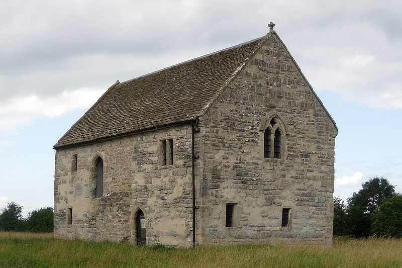
Church of St Saviour
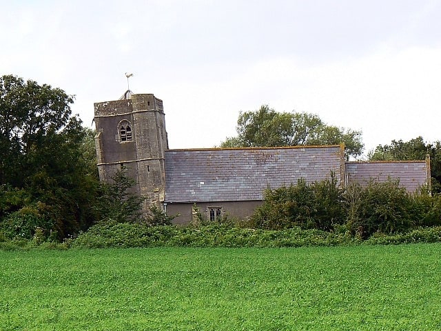
Building in England. The Church of The Holy Saviour in Puxton, Somerset, England, dates from the 13th century. It is recorded in the National Heritage List for England as a designated Grade I listed building, and is a redundant church in the care of the Churches Conservation Trust. It was vested in the Trust on 1 August 2002.
It is a small, mostly unaltered medieval church, which was originally a chapel of ease to the Church of St Andrew in Banwell. It was consecrated in 1539.
The leaning tower started to settle towards the southwest while being built, due to the peaty foundations which the church was built upon. This meant that the 15th century tower was never built as high as was intended. The church is externally Perpendicular in style, with an earlier Saxo-Norman nave.
The interior of the church is very light with a floor of irregular stone flags into which several ledger stones are set. The oak box pews on the north side of the nave are probably early 18th century, and the oak reading desk and pulpit are Jacobean, while the font is Norman. The royal arms of 1751 are over the south door. The 1557 labelled shield of Sir John St Lo's achievement can be seen above the entrance door. The Seyntloo (aka St Loe) family are past owners of Over Langford Manor.
In June 2000 structural problems were found with the roof timbers, the building was closed for some time, and on 2 July 2002, the church was declared redundant by Order in Council.[4]
Church of St Mary and St Edward
The Church of St Mary and St Edward is an Anglican parish church in Barrow Gurney, Somerset, England. It was built in the 12th century, but largely rebuilt in the 1880s, and has been designated as a Grade II* listed building.
The church was originally connected to the neighbouring Barrow Gurney Nunnery which became Barrow Court. It was originally built in the 12th century but was virtually rebuilt by Henry Woodyer 1887–90 for Henry Martin Gibbs son of William Gibbs of Tyntesfield.
It has a three-stage west tower surmounted by pinnacles and a spirelet. There is a two bay chancel, with a Cosmati work floor and four bay nave.
In 2013 an appeal was made for funds to help make repairs to the church including redecoration and servicing of the organ, which was largely unchanged since its construction by Vowles of Bristol around 1890.
The parish is part of the benefice of Long Ashton with Barrow Gurney and Flax Bourton within the deanery of Portishead, and the archdeaconry of Bath.[5]
Church of St Peter
Building in England. The Church of St Peter in Huntspill, Somerset, England was established by 1208, rebuilt around 1400, and extended in the early to mid 15th century. It was gutted by fire in 1878 and restored over the next two years. It has been designated as a Grade I listed building.
Before the Norman Conquest the Christian community at Huntspill was given by Offa of Mercia to Glastonbury Abbey. In the 13th century it was given to Tickford Priory at Newport Pagnell until it was taken under the control of the Bishop of Wells. Since the 18th century the patronage has been held by Balliol College, Oxford. The church's original dedication was to All Saints which changed to St Peter around 1872 and then in the 1950s the dedication to St Peter and All Hallows was adopted.
The church has a five bay nave and chancel and four stage west tower. The tower holds six beels which date from 1879 when they replaced the previous five the oldest of which was cast in 1693.
The church underwent extensive Victorian restoration between 1878 and 1880, following a major fire, which gutted the interior and roof leaving only the stonework still standing.
Refurbishment work to glass the lady chapel and the north door during 2011 was delayed when the company carrying out the work went into receivership.
The parish is part of the Huntspill and East Huntspill benefice within the Axbridge deanery.[6]
Street Heath
Street Heath is a 12.5 hectare biological Site of Special Scientific Interest 4 km west of Glastonbury in Somerset, notified in 1966. It next to the Glastonbury Canal and Ham Wall nature reserve. Street Heath has itself been designated as a Local Nature Reserve.
Street Heath is a nature reserve, managed by Somerset Wildlife Trust, which has outstanding examples of communities that were once common on the Somerset Levels. It possesses a vegetation consisting of wet and dry heath, species-rich bog and carr woodland, with transitions between all these habitats. Rare ferns present include marsh fern (Thelypteris palustris) and royal fern (Osmunda regalis). Old peat workings and rhynes have a wetland community which includes bulrush (Typha latifolia), yellow flag iris (pseudacorus), cyperus-like sedge (Carex pseudocyperus) and lesser bur-reed (Sparganium minimum). Insects recorded include 33 species of butterflies, 200 moths and 12 grasshoppers and crickets, with several notable rarities. Birds breeding in the carr woodland include the local willow tit[7]
Balt Moor Wall
Historical place in East Lyng, England. Balt Moor Wall is an earthwork and listed scheduled ancient monument in Lyng, Somerset, England, situated on the Somerset Levels to the northwest of the River Tone. The site contains the remains of a section of medieval causeway, which now forms a raised embankment between 6 metres and 10 metres wide and up to 2 metres high.
The structure, which English Heritage refers to as "a rare example of medieval engineering", appears to have been built to protect the Salt Moor from the flooding of the River Tone in the Athelney-Lyng gap.[8]
Petherton Park
Park in North Petherton, England. Petherton Park was a Deer park around North Petherton within the English county of Somerset.
The origins are unclear but the area was part of an earlier Royal Forest stretching from the River Parrett to the Quantock Hills. According to the late 13th century Hundred Rolls, King Henry II of England (d. 1189) gave William of Wrotham lands at North Petherton. During the reigns of Henry II (1154–1189) and Richard I (1189–1199), the royal forest of Petherton Park, was held from the crown by Osbert and William Dacus by grand serjeanty of being the king's Forester of Petherton. William de Plessis, who died in 1274 was granted Petherton Park and it was inherited by his son Richard de Barbeflote or Plessis.
The park was the only part of the royal estate which had not been granted away from royal ownership by the end of the 13th century. From 1391 until his death in 1400 the poet Geoffrey Chaucer was one of the foresters. He was succeeded by his son Thomas Chaucer.
At various points during the 13th and 14th centuries the park was the source of venison for royal feasts. The park was also a source of timber, which was granted by the king often to religious houses such as the Buckland Priory and the Friary and Nunnery in Ilchester. Between 1513 and 1535 Sir William Courtenay (d.1535) of Powderham, Devon was the keeper of North Petherton Park.
The park was visited by John Leland in 1538 who recorded that there were around 2000 deer in the park. Its extent was shown on the map of 1575 by Christopher Saxton and again in a map of 1610 by John Speed.
In 1583 the park was recorded as being owned by absentee landlords and falling into decline, although it was still a source of timber for sale. In 1584 part of the park was enclosed and leased. In 1638 the keeper Sir Thomas Wroth, of the Wroth baronets who had held the park since the reign of Elizabeth I, started to break up the park and by 1665 it had been divided into 11 different holdings, and by 1676 there were 15.
The Alfred Jewel, an Anglo-Saxon artefact made of enamel and quartz enclosed in gold, was discovered in the park in 1693, and is now one of the most popular exhibits at the Ashmolean Museum in Oxford. It has been dated from the late 9th century. It was made in the reign of Alfred the Great and is inscribed "AELFRED MEC HEHT GEWYRCAN", meaning 'Alfred ordered me made'. The jewel was once attached to a rod, probably of wood, at its base. After decades of scholarly discussion, it is now "generally accepted" that the jewel's function was to be the handle for a pointer stick for following words when reading a book. It is an exceptional and unusual example of Anglo-Saxon jewellery. There is a replica of the jewel in the Church of St Mary, North Petherton.
Maunsel House at North Newton, which was within the area of the earlier park, was built in the late 14th or early 15th century. Between 1648 and 1726 it was owned by the Bacon family who turned some the land into gardens, orchards and a fish pond.
The house which takes the name of Petherton Park was built in the 17th century. It is a Grade II listed building. It is now known as Petherton Park Farmhouse and has been divided into two separate houses. The two storey building has an eleven bay front. Two gatepiers at the entry to the site are also listed.[9]
The Abbot's Fish House
The Abbot's Fish House in Meare, Somerset, England, was built in the 14th century and has been designated as a Grade I listed building and Scheduled Ancient Monument. It is the only surviving monastic fishery building in England.
Fishing was an important source of food for the monks of Glastonbury Abbey. Fishing was carried out in artificial ponds, which were mentioned at Meare in the Domesday Book and from the River Brue and Meare Pool. The present rectangular stone building was constructed by the abbot between 1322 and 1335 for the storage and processing of the fish and as a residence for the chief fisherman. After the Dissolution of the Monasteries the building fell into disrepair and it was seriously damaged by fire in the 1880s. Some restoration has been undertaken during the 20th century, including the replacement of the roof in the 1920s.[10]
Down End Castle
Down End Castle, also known as Downend Castle, Chisley Mount or Chidley Mount, was a motte-and-bailey castle at Down End, north of Dunball in the parish of Puriton, Somerset, England. It has been designated as a Scheduled Ancient Monument.[11]
Church of All Saints
Building in Kingston Seymour, England. The Church of All Saints in Kingston Seymour, Somerset, England dates from the late 14th or early 15th century. It has been designated as a Grade I listed building.[12]
Church of St Christopher
Building in Lympsham, England. The Church of St Christopher in Lympsham, Somerset, England dates from the 15th century, and has been designated as a Grade I listed building.
It is known that Bartholomew de England was appointed rector at Lympsham in 1274, although the parish had been given by Ine of Wessex to Glastonbury Abbey in 690 remaining part of the Abbey estates until the dissolution of the monasteries in 1539.
During the 19th century extensive restoration was carried out by Rev A. J. Stephenson and his son, J. H. Stephenson. Further refurbishment was undertaken in 1909.
Archaeological exploration in 2001 uncovered a copper alloy coin from Bath dated 1670.
The parish is part of the benefice of Brent Knoll, East Brent and Lympsham, within the deanery of Axbridge.[13]
Westhay Heath
Westhay Heath is a 25.9 hectare biological Site of Special Scientific Interest 2km west of Westhay village in Somerset, notified in 1990.
Westhay Heath, which is managed by the Somerset Wildlife Trust is an area of tall fen vegetation containing scrub, marshy grassland, ditches and small ponds in the heart of the peat moors on the Somerset Levels. This mosaic of habitats has developed on areas previously used for peat extraction. The site is of importance for the presence of a nationally rare fen community, including a diverse assemblage of breeding and wintering birds.[14]
Westhay Moor
Westhay Moor is a 513.7-hectare biological Site of Special Scientific Interest 2.5 kilometres north-east of Westhay village and 4 kilometres from Wedmore in Somerset, England, notified in 1971. Westhay Moor is also notified as part of the Somerset Levels and Moors Special Protection Area under the EU Birds Directive and as a Ramsar site, and a National Nature Reserve.
The low-lying swampy area of Westhay Moor has had peat laid down over older rocks for the last 10,000 years. The Neolithic people lived on the areas of slightly higher ground but exploited the reed beds for materials and built wooden trackways to cross the raised bog. Peat extraction on the Somerset Levels has occurred since the area was first drained by the Romans. Measures to improve the drainage were carried out in the Middle Ages largely by Glastonbury Abbey. In the 17th and 18th centuries further drainage work was undertaken including digging a series of rhynes, or ditches and larger drainage canals. Peat extraction peaked in the 1960s but has since declined.
The geology of the moor and prolonged peat extraction has provided a unique environment which provides a habitat for a range of flora and fauna. Much of the nature reserve managed by the Somerset Wildlife Trust is based around abandoned peatworkings which have now become flooded. It is particularly noted for the millions of starlings which roost at the site in winter.[15]