Discover 11 hidden attractions, cool sights, and unusual things to do in Mount Robson Provincial Park (Canada). Don't miss out on these must-see attractions: Kinney Lake, Yellowhead Lake, and Emperor Falls. Also, be sure to include Rearguard Mountain in your itinerary.
Below, you can find the list of the most amazing places you should visit in Mount Robson Provincial Park (British Columbia).
Table of Contents
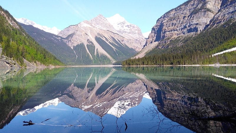
Kinney Lake
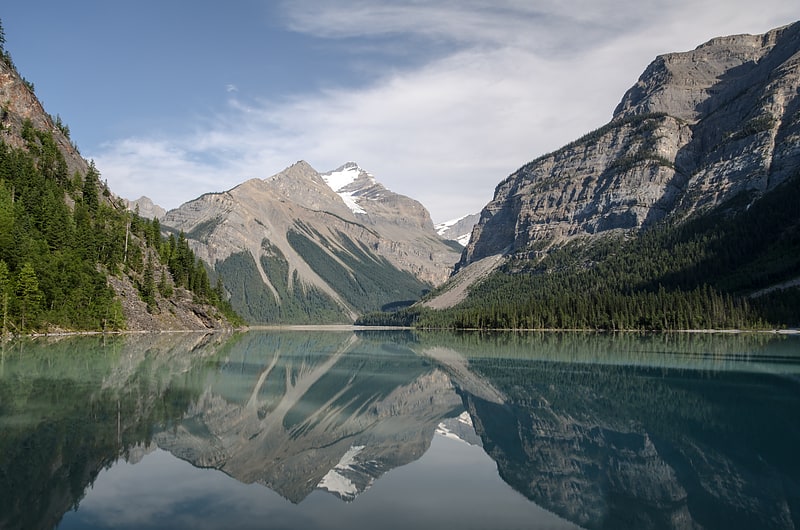
Lake in British Columbia, Canada. Kinney Lake is a lake located in Mount Robson Provincial Park of British Columbia, Canada. The lake can be reached by following the Berg Lake Trail for 4.2 kilometres. The lake is an expansion of the Robson River and is located about halfway between the river's source and its mouth. It was named by Arthur Philemon Coleman, Canadian geologist, who explored the region with his friend, George Kinney, who spotted the lake first.[1]
Yellowhead Lake
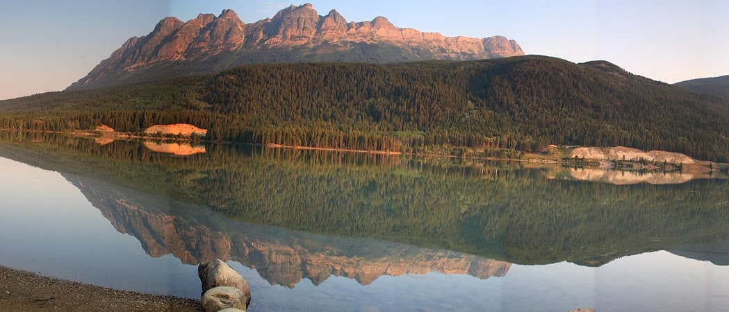
Lake in British Columbia, Canada. Yellowhead Lake is an irregularly shaped lake that is located about 3.7 km southwest of Yellowhead Pass within the boundaries of Mount Robson Provincial Park. It is on the lower reaches of Yellowhead Creek, a large creek that flows into the upper Fraser River above Moose Lake.[2]
Emperor Falls
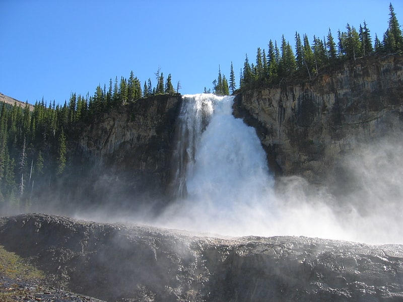
Waterfall in British Columbia, Canada. Emperor Falls is the largest and best known waterfall on the Robson River in Mount Robson Provincial Park. It is located a short distance downstream of and southwest from the outlet of Berg Lake.[3]
Rearguard Mountain
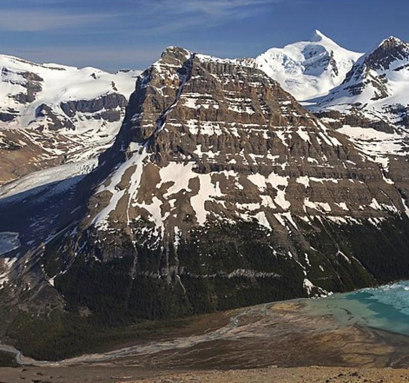
Summit in British Columbia, Canada. Rearguard Mountain is a 2,744-metre summit located within Mount Robson Provincial Park in British Columbia, Canada. It is part of the Rainbow Range which is a sub-range of the Canadian Rockies. Its nearest higher peak is Mount Robson, 4.0 km to the southwest. Rearguard is situated between Berg Lake and the Robson Glacier.[4]
Berg Lake
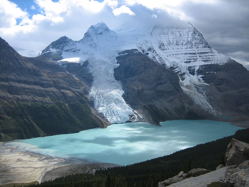
Scenic lake below Mount Robson. Berg Lake is a lake on the Robson River just below the river's source located within Mount Robson Provincial Park, at the doorstep of the north face of Mount Robson, the highest peak in the Canadian Rockies. It is partly fed by the Berg Glacier.
The turquoise colored Berg Lake is dotted with icebergs even in the middle of summer. Berg Lake can be reached by following a marked hiking trail for 19 kilometres (12 mi) from the parking lot. To reach the parking lot, follow Highway 5 north from Valemount to Highway 16 and head east 18 kilometres (11 mi). Or, follow Yellowhead Highway 16 west from Jasper townsite for 84 kilometres (52 mi) to the Mount Robson Viewpoint centre. On the north side of the highway, follow a two-lane paved road for 2 kilometres (1.2 mi), ending at the parking lot.[5]
Cinnamon Peak
Mountain in British Columbia, Canada. Cinnamon Peak is a 2,727-metre mountain summit located in the northwestern part of Mount Robson Provincial Park, in the Canadian Rockies of British Columbia, Canada. It is situated immediately north of the confluence of the Robson River and the Fraser River, and is visible from the Yellowhead Highway near the park's visitor centre. The peak was labelled "Little Grizzly" on Arthur Oliver Wheeler's 1911 topographic map of Mount Robson. He thought it appeared similar to Mount Grizzly in the Selkirk Mountains, but the name was later changed to Cinnamon, which is the coloration of the peak and the Cinnamon bear, which can be easily mistaken for a grizzly bear. "Little Grizzly" is a colloquial term for the black bear, Ursus americanus. Eastern populations are typically black in color, however western populations can be cinnamon colored. The mountain's name was officially adopted in 1951 by the Geographical Names Board of Canada. Its nearest higher peak is Whitehorn Mountain, 6.0 km to the north.[6]
Resplendent Mountain
Peak in British Columbia, Canada. Resplendent Mountain, or Mount Resplendent is a peak in the Canadian Rockies, located within Mount Robson Provincial Park in British Columbia, Canada. It is a part of the Rainbow Range, and is a sister peak to the more famous Mount Robson, its nearest neighbour. Together they form a classic panorama seen by travellers from the VIA railway and Highway 16. The mountain was named by Arthur P. Coleman, and A.O. Wheeler wrote, "On the east side it is clad from top to bottom in pure white snow, and presents with the sun shining upon it a spectacle of such wonderful brilliance that the aptness of the name became immediately apparent." The first ascent was achieved on the same historic 1911 trip in which Conrad Kain first scouted the climbing routes later to be used on the first ascent of Mount Robson.
The east face of Resplendent towers above the sources of Resplendent Creek, feeding into the Moose River, and its north face emerges from the Robson Glacier, feeding the Robson River, another tributary of the upper headwaters of the Fraser River. Resplendent holds an important place in the history of Canadian Rockies ski mountaineering, and from the time of Peter L. Parson's first ski ascent (solo) in 1930, it has been a highly sought objective for winter ascents, with a ski descent of over 1800m from the summit to the toe of the Robson Glacier.[7]
Canadian Rockies
Mountain in Canada. The Canadian Rockies or Canadian Rocky Mountains, comprising both the Alberta Rockies and the B.C. Rockies, is the Canadian segment of the North American Rocky Mountains. It is the easternmost part of the Canadian Cordillera, which is the northern segment of the North American Cordillera, the expansive system of interconnected mountain ranges between the Interior Plains and the Pacific Coast that runs northwest–southeast from central Alaska to the Isthmus of Tehuantepec in Mexico.
Canada officially defines the Rocky Mountains system as the mountain chains east of the Rocky Mountain Trench extending from the Liard River valley in northern British Columbia to the Albuquerque Basin in New Mexico, not including the Mackenzie, Richardson and British Mountains/Brooks Range in Yukon and Alaska (which are all included as the "Arctic Rockies" in the United States' definition of the Rocky Mountains system). The Canadian Rockies, being the northern segment of this chain, is thus defined as comprising the central-eastern section of the North American Cordillera, between the Prairies of Alberta and the Liard Plain of northeastern British Columbia to the east and the Interior Mountains/Plateau and Columbia Mountains to the west. It is divided into the Northern Rockies (which is further subdivided into the Muskwa and Hart Ranges) and Continental Ranges, separated by the McGregor River valley, the McGregor Pass and the Kakwa River valley.
The southern end of the Canadian Rockies extends into the U.S. state of Montana at various sites such as the Wilson Range, Upper Waterton Lake, Boundary Creek, Cameron Lake, Forum Peak, Long Knife Peak, North Fork Flathead River and Frozen Lake. In geographic terms, the boundary is at the Canada–United States border on 49th parallel north, but in geological terms it might be considered to be at Marias Pass in northern Montana.
The Canadian Rockies have numerous high peaks and ranges, such as Mount Robson (3,954 m, 12,972 ft) and Mount Columbia (3,747 m, 12,293 ft). The Canadian Rockies are composed of shale and limestone. Much of the range is protected by national and provincial parks, several of which collectively comprise a World Heritage Site.[8]
Mount Robson
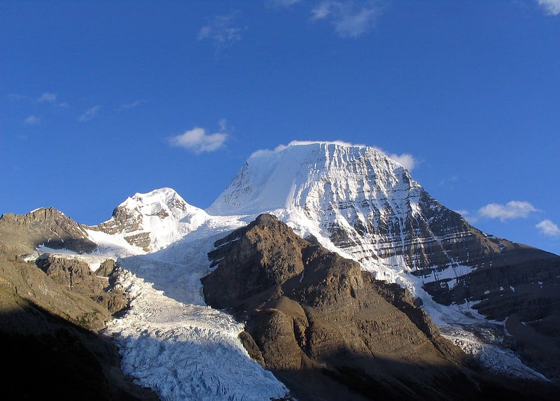
Iconic peak with hiking paths and glaciers. Mount Robson is the most prominent mountain in North America's Rocky Mountain range; it is also the highest point in the Canadian Rockies. The mountain is located entirely within Mount Robson Provincial Park of British Columbia, and is part of the Rainbow Range. Mount Robson is the second highest peak entirely in British Columbia, behind Mount Waddington in the Coast Range. The south face of Mount Robson is clearly visible from the Yellowhead Highway, and is commonly photographed along this route.
Mount Robson was likely named after Colin Robertson, who worked for both the North West Company and the Hudson's Bay Company at various times in the early 19th century, though there was confusion over the name as many assumed it to have been named for John Robson, an early premier of British Columbia. The Texqakallt, a Secwepemc people and the earliest inhabitants of the area, call it Yexyexéscen (striped rock), spelled in Dawson 1891 as Yuh-hai-has-kun, The Mountain of the Spiral Road. Other unofficial names include Cloud Cap Mountain.[9]
Whitehorn Mountain
Peak in British Columbia, Canada. Whitehorn Mountain is a 3,399-metre peak located in eastern British Columbia, Canada near the Alberta border. It is one of British Columbia's 102 ultra prominent peaks.
Whitehorn Mountain was first climbed by Conrad Kain in a rare solo ascent for him. Kain was in the Mount Robson area guiding a reconnaissance party led by Arthur Wheeler in 1911 when he completed the solo ascent, much to the disgruntlement of Wheeler.[10]
Lynx Mountain
Mountain in British Columbia, Canada. Lynx Mountain is a mountain peak in the Canadian Rockies. It is located on the Continental Divide between the provinces of Alberta and British Columbia, in the Cushina Ridge of the Continental Ranges. It was named by Lucius Quincy Coleman for the remains of a lynx they found on the ice of the nearby Coleman Glacier in 1908.
Reaching an elevation of 3,192 metres (10,472 ft), it lies in both the Mount Robson Provincial Park and Jasper National Park.
The Lynx Formation, a stratigraphic unit of the Western Canada Sedimentary Basin, was named for the mountain by Charles Doolittle Walcott in 1913.[11]