Discover 11 hidden attractions, cool sights, and unusual things to do in Inyo National Forest (United States). Don't miss out on these must-see attractions: June Mountain ski area, Convict Lake, and Panum Crater. Also, be sure to include Twin Lakes in your itinerary.
Below, you can find the list of the most amazing places you should visit in Inyo National Forest (California).
Table of Contents
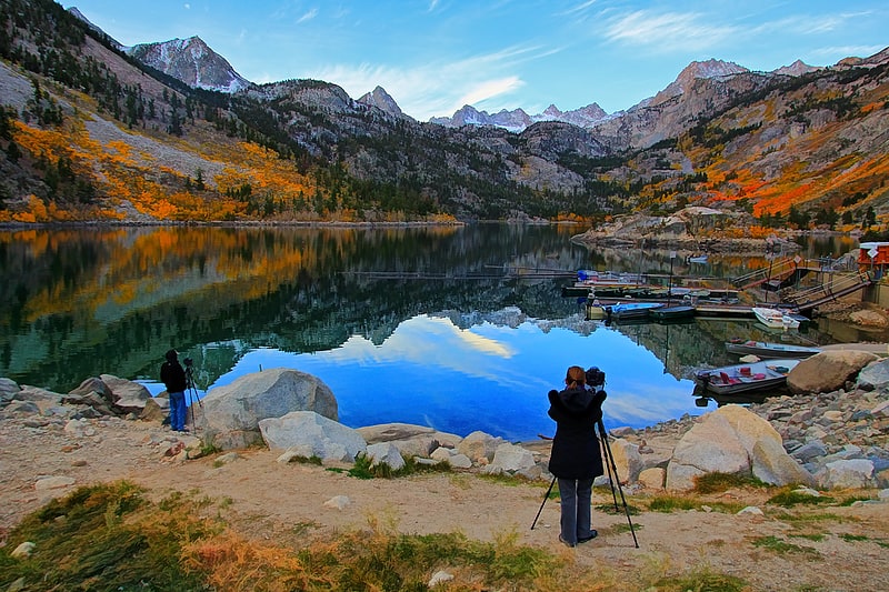
June Mountain ski area
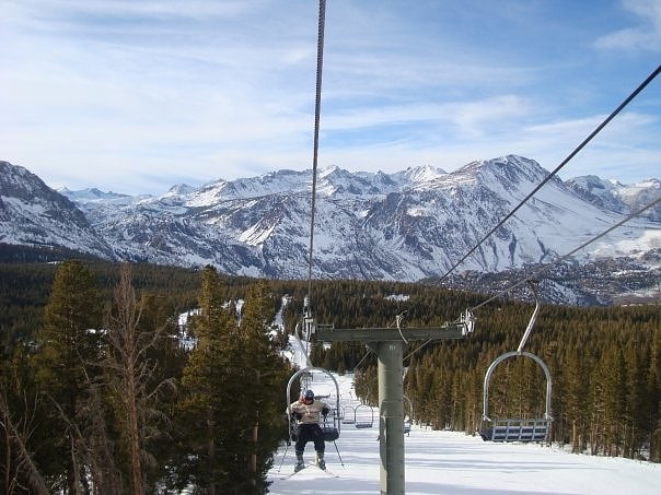
Ski area in June Lake, California. June Mountain ski area is a winter resort in the Eastern Sierra Nevada Mountains, located near June Lake, southeast of Yosemite National Park.
June Mountain, like its neighbor and current owner, Mammoth Mountain Ski Area, has traditionally been popular with skiers from Southern California, in part because of its relative ease of automobile access in winter compared to the Lake Tahoe resorts, which are traditionally more accessible to Northern California residents. It is also popular with locals, elementary and high school ski programs, and race teams in the surrounding small towns of Mono County, many of whom depend on the resort for a substantial portion of their winter tourism base.
June Mountain hosted the 2006 Ski Mountaineering Race Series and the ski and snowboard portions of the 2006 California Winter Games in March 2006.
June Mountain also offers chair lift rides to the chalet throughout the summer and contains hiking trails and other scenic features that are accessible throughout the summer months.
On June 21, 2012, Mammoth Mountain and the Starwood Capital Group announced that they would close June Mountain for the summer and winter 2012–2013 season, after 50 years of continuous operation. An active citizen movement arose in response, raising concerns about the prospects for sustaining the local community if the mountain closed. With a new strategy to finally invest in snowmaking, a chairlift, and marketing, June Mountain re-opened for the 2013–2014 season.
In 2014, Mammoth Mountain purchased Bear Mountain and Snow Summit for $38 million. In 2017, Mammoth Resorts announced its sale by Starwood to a partnership of Aspen Skiing Company and KSL Capital Partners, later named Alterra Mountain Company.[1]
Address: 3819 Hwy 158, 93529 June Lake
Convict Lake
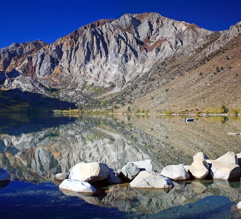
Lake in California. Convict Lake is a lake located in Mono County, California, United States, situated in the Sherwin Range of the Sierra Nevada mountains. It is known for its turquoise-blue water, the dramatic mountains that surround it, the trout fishing it affords, and its unusual history. The lake was renamed from its traditional Mono name by American settlers after an incident on September 23, 1871, in which a group of convicts escaped from prison in Carson City, Nevada, and took refuge near the lake. They were pursued by a posse, and after it caught up to the convicts, a shootout followed, in which a number of both posse members and convicts were killed or wounded. The remaining convicts who survived initially escaped but were eventually captured to be taken back to prison but were lynched instead.[2]
Panum Crater
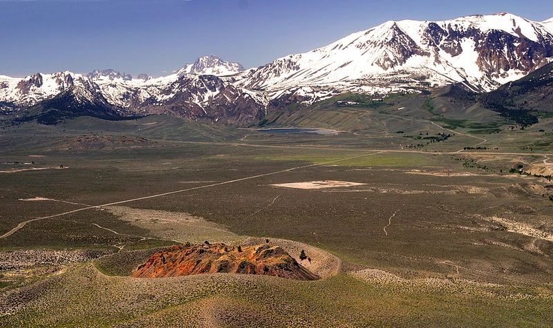
Volcano in California. Panum Crater is a volcanic cone that is part of the Mono–Inyo Craters, a chain of recent volcanic cones south of Mono Lake and east of the Sierra Nevada, in California, United States. Panum Crater is between 600 and 700 years old, and it exhibits all of the characteristics of the textbook rhyolitic lava dome.
Rhyolitic volcanoes are characterized by having large amounts of silica (quartz) in their lava. The content of silica at Panum is about 76 percent. It makes the lava very viscous, or thick, and very glassy. Products of this rhyolitic eruption are pumice and obsidian, the volcanic glass that Native Americans used to make arrow points and scrapers.
Panum Crater formed in a sequence of events. The first event was caused by magma rising from deep within the Earth's crust. When this extremely hot, liquid rock made contact with water just below the surface, the water expanded into steam and a large, violent eruption occurred. The material that was thrown into the air by the steam, mainly old lake bottom sediments, was deposited around the new vent in little mounds. So much debris was blown out that a gaping crater was left behind.
Once this debris was blown out, a fountain of cinders shot up a great distance into the sky. As this huge amount of ash and pumice began to fall back towards the earth, it formed a pumice ring, or cinder cone, about the original vent. This cinder cone is still visible today.
Following the violent eruptions of the first two phases, the remainder of the thick magma slowly rose to the surface in a series of domes. Each dome began with an outpouring of the viscous, rhyolitic lava which hardened and formed a cap over the vent. As magma continued to push up, the cap (or dome) shattered and fell to the outside of the newly formed dome. This happened so many times that a new mountain was created out of these broken pieces, called crumble breccia. The mountain continued to build in this manner until the force within the volcano weakened and no more new domes formed. The final one still stands today.
As the final dome hardened, a period of spire building began. Thick lava pushed up through cracks of the hardening dome and formed castle-like spires. The formation of the spires was analogous to toothpaste squeezing through the opening of a tube and forming a small tower before it topples over. Most of the spires at Panum fell over and broke because of their rapid cooling and because of many small explosions at their bases. Most of the rocky debris at the top of the dome is the remains of spires that have crumbled.
The central lava dome was erupted from degassed material and is made up of pumice and obsidian of the same composition. The difference between the two has to do with gas escaping as the magma cooled. The magma that created the dome had dissolved gas in it, like a bottle of seltzer water. As the magma rose towards the surface where there was less pressure on it than at depth, the gas expanded producing the holes or bubbles in the pumice. The magma that remained pressurized while it cooled quickly or that had already lost its gas, formed the obsidian.
Flow banding containing both obsidian and pumice is common at Panum Crater. Another common texture, called breadcrust, can also be seen in the dome. Breadcrust textures form when the inside of a cooling rock is still hot with gas escaping from it while the outside surface has already cooled. As the gas expands from the inside, the outside surface cracks to allow the gas to escape.[3]
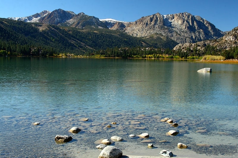
Twin Lakes
Lake in California. Twin Lakes in Mono County, California can refer to:
- Twin Lakes (Mammoth Lakes, California), approximately 3 miles (5 km) southwest of Mammoth Lakes town center
- Twin Lakes (Bridgeport, California), approximately 9 miles (14 km) southwest of Bridgeport
- Twin Lakes, Mono County, California, a census-designated place surrounding the Twin Lakes southwest of Bridgeport
Address: 518 TWIN Lks, Inyo National Forest
Lake Sabrina
Lake in California. Lake Sabrina is a lake created by damming the middle fork of Bishop Creek. It is located south-west of Bishop, California on California State Route 168, in the Inyo National Forest. It has a cafe as well as a dock. The dam was built in 1907–8 to supply a constant flow of water to the hydraulic power plants. The lake is part of the Bishop Creek system.
Local residents pronounce the lake "Sah-bry-nuh;" however, the lake was originally named after Mrs. Sabrina (pronounced: suh-BREE-nuh) Hobbs, wife of C.M. Hobbs first General Manager of California Nevada Power Company which built the dam. The reason for the lake's name pronunciation changing over the years is unclear.
The segment of the State Route 168 from Lake Sabrina east to the community of Aspendell is subject to closure to most vehicles during the winter months, usually not opening until mid- or late-April, due to snow removal. The winter road closure gate is actually located to the southwest of Aspendell.[5]
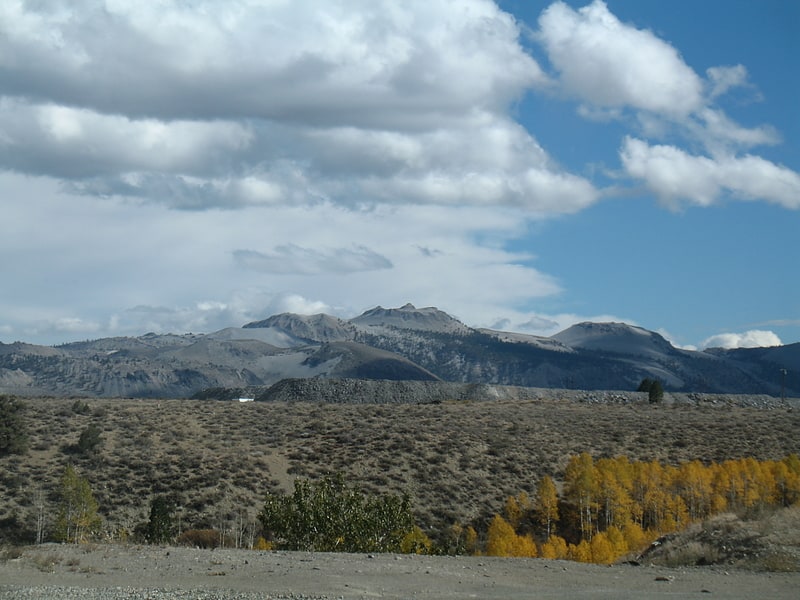
White Mountain Peak
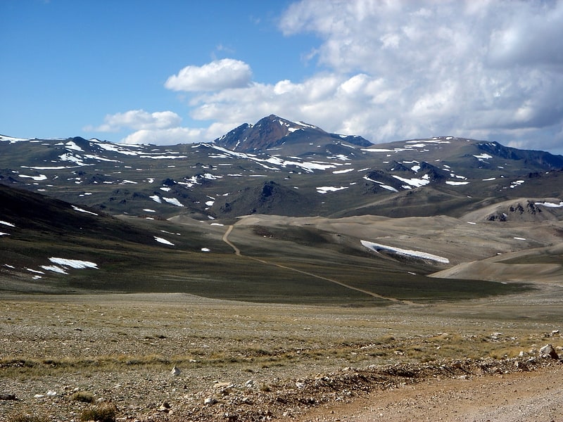
Peak in California. White Mountain Peak, at 14,252-foot, is the highest peak in the White Mountains of California, the highest peak in Mono County, and the third highest peak in the state after Mount Whitney and Mount Williamson.
It is the fourteenth most topographically prominent peak in the contiguous United States. White Mountain Peak is one of only two fourteeners (peaks above 14,000 feet) in California that are not in the Sierra Nevada, the other being Mount Shasta at the far northern end of the state in the Cascade Range. It is the only fourteener in the contiguous United States that is not in the Rocky Mountains, the Cascade Range, or the Sierra Nevada.[6]
June Lake
June Lake is a subalpine lake within the Inyo National Forest, in Mono County, eastern California. It is at an elevation of 7,621 ft in the Eastern Sierra Nevada.[7]
Agnew Lake
Lake in California. Agnew Lake is a lake in Mono County, California, in the United States.
Agnew Lake was named for Theodore C. Agnew, an early settler.[8]
Mono Basin National Scenic Area
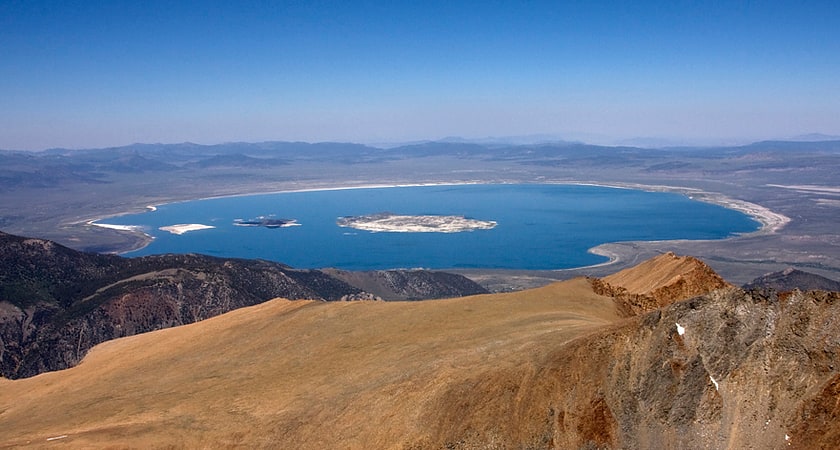
Nature preserve in Mono County, California. The Mono Basin National Forest Scenic Area is a protected area in Eastern California that surrounds Mono Lake and the northern half of the Mono Craters volcanic field. It is administered by the Inyo National Forest as a unit of the National Forest Scenic Area program, under the U.S. Forest Service.[9]
Methuselah Tree
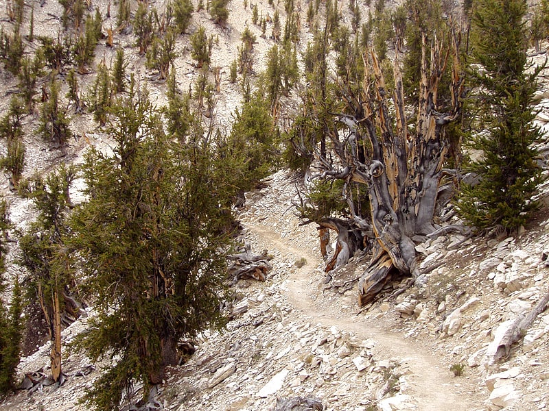
Great basin bristlecone pine. Methuselah is a 4,853-year-old Great Basin bristlecone pine tree growing high in the White Mountains of Inyo County in eastern California. It is recognized as the non-clonal tree with the greatest confirmed age in the world. The tree's name refers to the biblical patriarch Methuselah, who ostensibly lived to more than 900 years of age, thus synonymous with longevity.[10]
Mono–Inyo Craters
Mountain chain in California. The Mono–Inyo Craters are a volcanic chain of craters, domes and lava flows in Mono County, Eastern California. The chain stretches 25 miles from the northwest shore of Mono Lake to the south of Mammoth Mountain. The Mono Lake Volcanic Field forms the northernmost part of the chain and consists of two volcanic islands in the lake and one cinder cone volcano on its northwest shore. Most of the Mono Craters, which make up the bulk of the northern part of the Mono–Inyo chain, are phreatic volcanoes that have since been either plugged or over-topped by rhyolite domes and lava flows. The Inyo volcanic chain form much of the southern part of the chain and consist of phreatic explosion pits, and rhyolitic lava flows and domes. The southernmost part of the chain consists of fumaroles and explosion pits on Mammoth Mountain and a set of cinder cones south of the mountain; the latter are called the Red Cones.
Eruptions along the narrow fissure system under the chain began in the west moat of Long Valley Caldera 400,000 to 60,000 years ago. Mammoth Mountain was formed during this period. Multiple eruptions from 40,000 to 600 years ago created the Mono Craters and eruptions 5,000 to 500 years ago formed the Inyo volcanic chain. Lava flows 5,000 years ago built the Red Cones, and explosion pits on Mammoth Mountain were excavated in the last 1,000 years. Uplift of Paoha Island in Mono Lake about 250 years ago is the most recent activity. These eruptions most likely originated from small magma bodies rather than from a single, large magma chamber like the one that produced the massive Long Valley Caldera eruption 760,000 years ago. During the past 3,000 years, eruptions have occurred every 250 to 700 years. In 1980, a series of earthquakes and uplift within and south of Long Valley Caldera indicated renewed activity in the area.
The region has been used by humans for centuries. Obsidian was collected by Mono Paiutes for making sharp tools and arrow points. Glassy rock continues to be removed in modern times for use as commercial scour and yard decoration. Mono Mills processed timber felled on or near the volcanoes for the nearby boomtown Bodie in the late 19th to early 20th centuries. Water diversions into the Los Angeles Aqueduct system from their natural outlets in Mono Lake started in 1941 after a water tunnel was cut under the Mono Craters. Mono Lake Volcanic Field and a large part of the Mono Craters gained some protection under Mono Basin National Forest Scenic Area in 1984. Resource use along all of the chain is managed by the United States Forest Service as part of Inyo National Forest. Various activities are possible along the chain, including hiking, bird watching, canoeing, skiing, and mountain biking.[11]