Discover 11 hidden attractions, cool sights, and unusual things to do in Yorkshire Dales (United Kingdom). Don't miss out on these must-see attractions: Aysgarth Falls, Garsdale, and Jingling Pot. Also, be sure to include Pen-y-ghent in your itinerary.
Below, you can find the list of the most amazing places you should visit in Yorkshire Dales (England).
Table of Contents
Aysgarth Falls
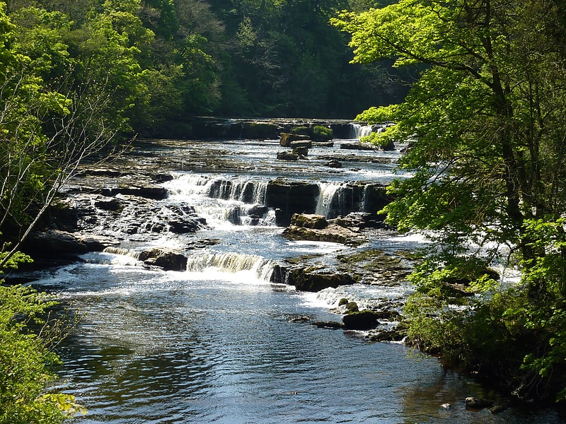
Waterfall. Aysgarth Falls are a triple flight of waterfalls, surrounded by woodland and farmland, carved out by the River Ure over an almost one-mile stretch on its descent to mid-Wensleydale in the Yorkshire Dales of England, near the village of Aysgarth. The falls are quite spectacular after heavy rainfall as thousands of gallons of water cascade over the series of broad limestone steps, which are divided into three stages: Upper Force, Middle Force and Lower Force.
The falls are an SSSI.
Aysgarth Falls have attracted visitors for more than 200 years, including John Ruskin, J. M. W. Turner and William Wordsworth visited, all enthusing about the falls' outstanding beauty. All three falls were featured in the film Robin Hood: Prince of Thieves.
The Falls are situated in the Yorkshire Dales National Park. There is a visitors' centre with an exhibition, information, items for sale, a café, toilets and a pay-and-display car park.
There are public footpaths through the wooded valley, offering views of the river and falls. Wild flowers appear in the spring and summer, for example snowdrops in January and February, primroses in April and bluebells in May, and birds, squirrels and deer may also be seen. Occasionally salmon can be seen leaping up the falls in autumn. Nearby is St Andrew's Church, which has what is reputed to be the largest churchyard in England. The church has a medieval painted wooden screen rescued from the destroyed Jervaulx Abbey.
The name originates from Old Norse and means the open space in the oak trees.
It was featured on the television programme Seven Natural Wonders as one of the wonders of the North.[1]
Garsdale
Locality in England. Garsdale is a dale or valley in the south east of Cumbria, England, historically a part of the West Riding of Yorkshire. It is now within the South Lakeland local government district, but is still a "Yorkshire Dale" for planning purposes. In the 2001 census the parish had a population of 202, decreasing at the 2011 census to 191.
Garsdale is on the western slopes of the Pennines, between Baugh Fell to the north, and Rise Hill to the south. It is within the Yorkshire Dales National Park. The dale is the valley of the Clough River, which rises on the north eastern slopes of Baugh Fell and flows through Grisedale, the Dale that Died, as Grisedale Beck until it becomes the Clough River at Garsdale Head.
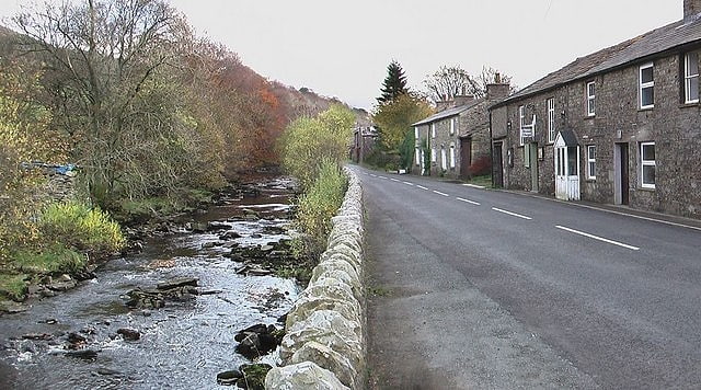
The dale forms the civil parish of Garsdale (though the last mile and a half of the course of the Clough river, before its confluence with the Rawthey, is part of the parish of Sedbergh). Small settlements lie along the main Northallerton to Kendal road (the A684) which runs through the dale for 7 miles (11 km), with frequent bridges in the upper part of the dale. The largest settlement, known as "The Street", lies 6 miles (9.7 km) east of Sedbergh, and 10 miles (16 km) west of Hawes. The other hamlet in Garsdale is Garsdale Head, also called Hawes Junction, the old name for Garsdale railway station, after the former Wensleydale branch on the Settle to Carlisle railway.
At Longstone Fell, locally known, and spoken as Langst'n Fell, the A684 road rises to a well-known view-point looking over the Howgill Fells, and the river descends to Danny Bridge, the site of a 17th-century mill on the "old road", before joining the River Rawthey near Sedbergh. The Sedgwick Trail, named after the well-known geologist Adam Sedgwick runs along the Clough from Danny Bridge and highlights rock features along the Dent Fault.[2]
Jingling Pot
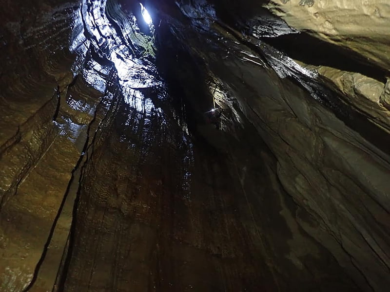
Cave in England. Jingling Pot is a limestone cave in West Kingsdale, North Yorkshire, England. Located adjacent to Jingling Beck, it is a lenticular-shaped 45-metre deep shaft that descends straight from the surface. At the bottom the rift extends to the north and descends steeply into a further chamber, at the end of which the initials of the original explorers may be seen scratched into the rock. A narrow shaft in this second chamber drops into a complex of small crawls and rifts, which approach close to a passage in the One-armed Bandit Series of Aquamole Pot. A second set of shafts descend parallel to the surface shaft. These can be entered through a rock window a little way below the entrance.[3]
Pen-y-ghent
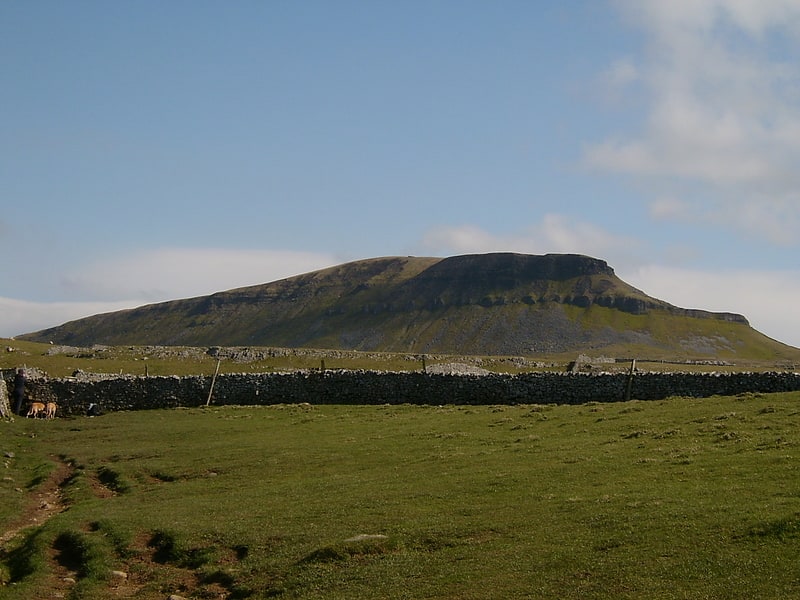
Fell in England. Pen-y-ghent or Penyghent is a fell in the Yorkshire Dales, England. It is the lowest of Yorkshire's Three Peaks at 2,277 feet; the other two being Ingleborough and Whernside. It lies 1.9 miles east of Horton in Ribblesdale. It has a number of interesting geological features, such as Hunt Pot, and further down, Hull Pot. The waters that flow in have created an extensive cave system which rises at Brants Gill head.
In 2004 the body of Lamduan Armitage, dubbed by the media the "Lady of the Hills", was found near to the entrance of Sell Gill Hole.[4]
Swinsto Cave
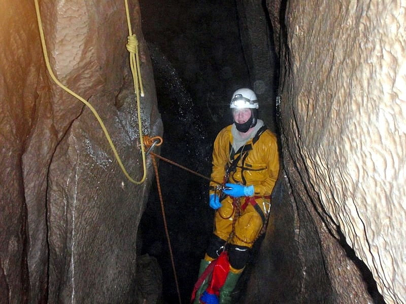
Swinsto Cave is a limestone cave in West Kingsdale, North Yorkshire, England. It leads into Kingsdale Master Cave and it is popular with cavers as it is possible to descend by abseiling down the pitches, retrieving the rope each time, and exiting through Valley Entrance of Kingsdale Master Cave at the base of the hill. It is part of a 27-kilometre long cave system that drains both flanks of Kingsdale.[5]
Semerwater
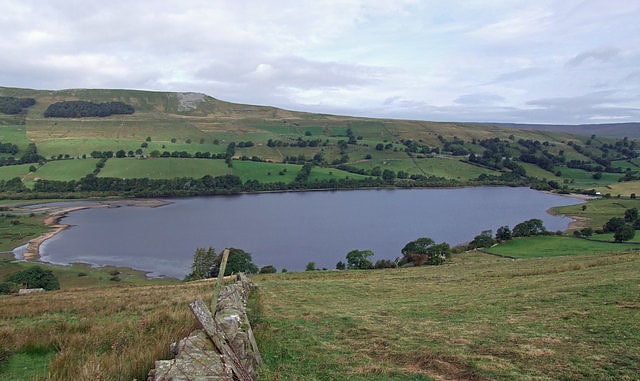
Lake in England. Semerwater is the second largest natural lake in North Yorkshire, England, after Malham Tarn. It is half a mile long, covers 100 acres and lies in Raydale, opposite the River Bain. A private pay and display parking area is at the foot of the lake.
Semerwater attracts canoers, windsurfers, yachtsmen and fishermen. There are three small settlements nearby:
- Stalling Busk
- Countersett
- Marsett
Semerwater was the subject of a number of sketches and paintings by the artist J M W Turner.
Semerwater is a pleonastic place name. The name, first recorded in 1153, derives from the Old English elements sæ 'lake', mere 'lake' and water. The form "Lake Semerwater" introduces a fourth element with the same meaning.
The lake is a Site of Special Scientific Interest, first notified in 1975.[6]
Ellerton Priory
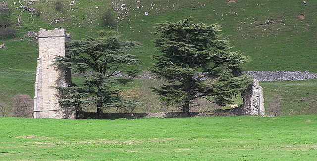
Priory. Ellerton Priory was a priory of Cistercian nuns in Swaledale in North Yorkshire, England. Its ruins lie in the civil parish of Ellerton Abbey.[7]
Fountains Fell Tarn
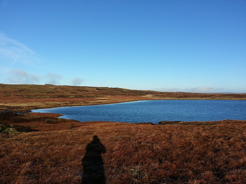
Lake. Fountains Fell Tarn, is an upland lake between the two peaks of Fountains Fell, in North Yorkshire, England. The tarn is close to the Pennine Way, some 4.3 miles north west of Malham Tarn, and 4.3 miles east of Horton in Ribblesdale. Water from the tarn flows eastwards through Cowside Beck, which is a tributary of the River Skirfare in Littondale. Whilst the water in the lake is acidic, as it runs off the mountain, it flows over Yoredale beds limestone and so becomes a harder water.[8]
Skeldale House
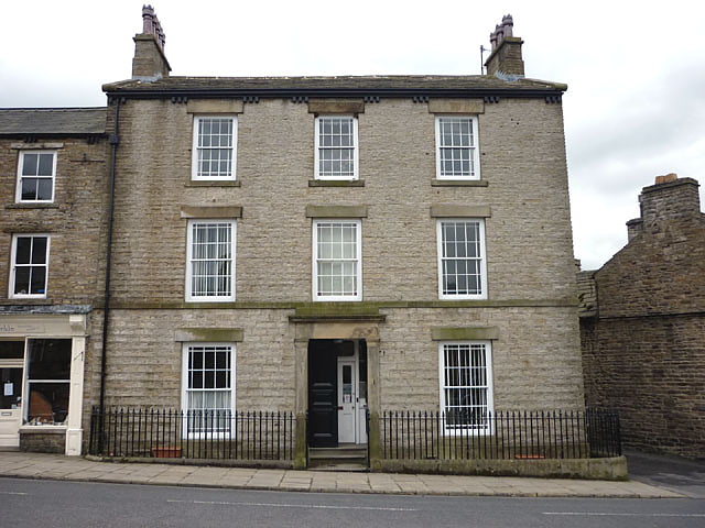
Building in Askrigg, England. Cringley House is an historic building in the English village of Askrigg, North Yorkshire. Standing on the south side of Market Place, it was built in the early-to-mid 19th century, and is now a Grade II listed building. Its railings are also of listed status.
It became known as "Skeldale House" after its use as the exterior of the Darrowby veterinary surgery of Siegfried Farnon and James Herriot in the original BBC television series All Creatures Great and Small. The real Skeldale House, where Herriot worked, is on Kirkgate in Thirsk. The building is now occupied by Skeldale House Bed and Breakfast, although it was put up for sale in late 2020.
Peter Davison, who played Siegfried Farnon's younger brother and fellow vet Tristan in said television series, recalled its owners in the 1970s and 1980s: " owned by Olive Turner and her husband Charles, who welcomed us with open arms from the first day of filming. Although we never shot any interior scenes there, it was often used for make-up and costume and, while relaxing between takes, they would make us tea and coffee and show us pictures of their children. The couple even appeared as extras in a couple of scenes."
An early occupant, in the 1920s was Billy Banks, whose family ran the grocer's shop and the animal feed store in Askrigg. In the late 20th century and early 21st, it was used as a care home and a housing association.[9]
St Matthew's Church
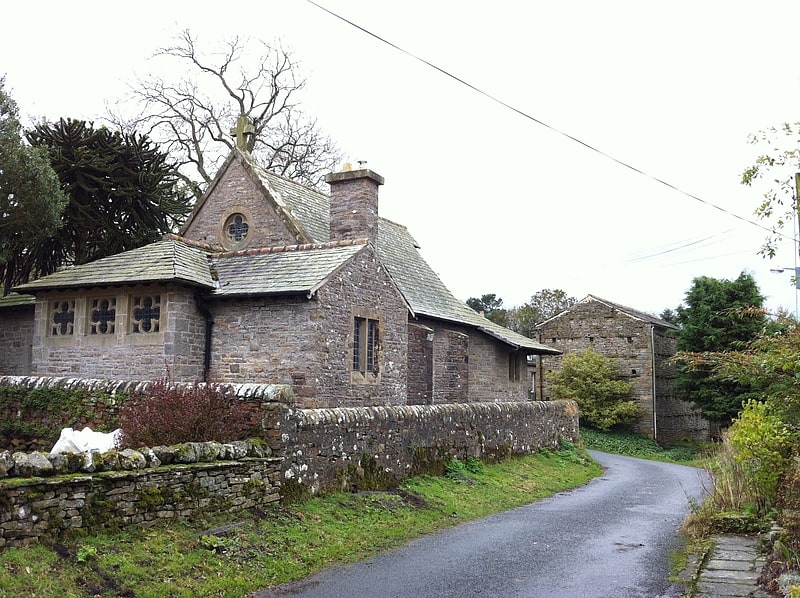
St Matthew's Church, Stalling Busk is a Grade II listed parish church in the Church of England in Stalling Busk, North Yorkshire.[10]
Malham Moor
English civil parish. Malham Moor is a civil parish in the Craven district of North Yorkshire, England. Its population was estimated at 70 in 2015.
It has a joint parish council, Kirkby Malhamdale Parish Council, with the parishes of Malham, Kirkby Malham and Hanlith.
There is no village in the parish. The parish includes scattered farms and houses, Malham Tarn and large areas of moorland, including Fountains Fell. The upland area identified on Ordnance Survey maps as Malham Moor lies outside the parish, to the east. It is north west of Threshfield along Malham Moor Lane. Its summit is at 411m.(SD952648)
Malham Moor was historically a township in the ancient parish of Kirkby Malham in the West Riding of Yorkshire. It became a civil parish in 1866, and in 1974 was transferred to the new county of North Yorkshire.[11]