Discover 20 hidden attractions, cool sights, and unusual things to do in North York Moors (United Kingdom). Don't miss out on these must-see attractions: Rievaulx Abbey, Farndale, and Roseberry Topping. Also, be sure to include St Michael's Church in your itinerary.
Below, you can find the list of the most amazing places you should visit in North York Moors (England).
Table of Contents
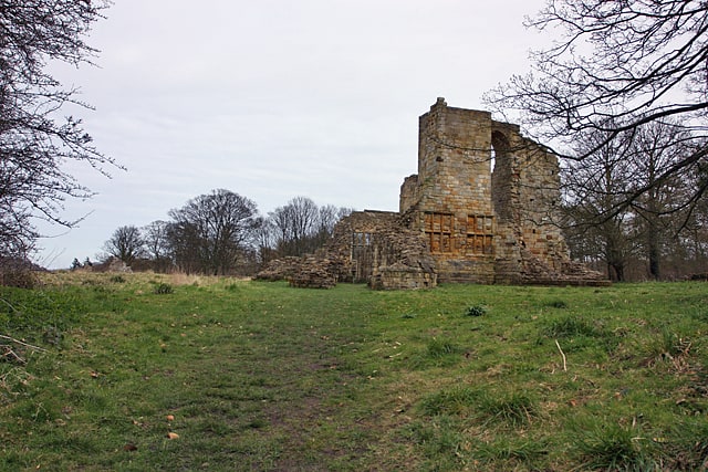
Rievaulx Abbey
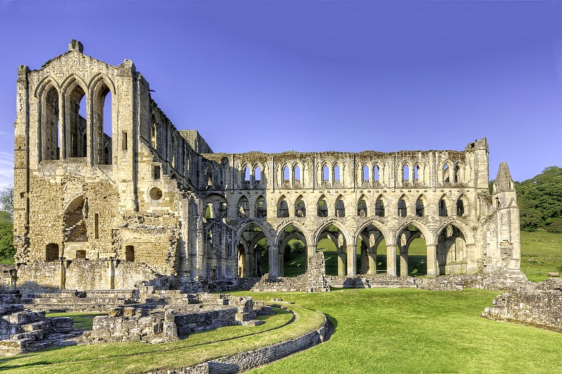
Valley-bound Cistercian abbey ruins. Rievaulx Abbey ree-VOH was a Cistercian abbey in Rievaulx, situated near Helmsley in the North York Moors National Park, North Yorkshire, England. It was one of the great abbeys in England until it was seized under Henry VIII of England in 1538 during the dissolution of the monasteries. The wider site was awarded Scheduled Ancient Monument status in 1915 and the abbey was brought into the care of the Ministry of Works in 1917. The striking ruins of its main buildings are a tourist attraction, owned and maintained by English Heritage.[1]
Address: Rievaulx Bank, YO62 5LB North Yorkshire
Farndale
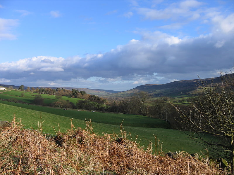
Farndale is a valley and community in Ryedale district, North Yorkshire, England, which is known for the daffodils which flower each spring along a 7-mile stretch of the River Dove. The valley is in the North York Moors National Park, some 11 miles north of Kirkbymoorside, the nearest town. Pickering is some 17 miles to the south-east and Helmsley 17 miles to the south-west.
The combined population of the civil parishes of Farndale East and Farndale West was 207 in 2011, and was estimated to have dropped to 180 by 2015.
Farndale is an isolated, scattered agricultural community with traditional Yorkshire dry stone walls. The valley is popular with walkers due to its famous wild daffodils, which can be seen around Easter time all along the banks of the River Dove. To protect the daffodils the majority of Farndale north of Lowna was created a Local Nature Reserve in 1955.
Farndale is home to two hamlets; Church Houses at the top of the valley and Low Mill further down. Low Mill is a tourist honeypot during daffodil season as this is where the famous daffodil walk begins. The other end of the daffodil walk is at High Mill a cluster of houses a short distance down a lane from Church Houses.
The annual Farndale Agricultural Show which is held on the Summer Bank Holiday Monday in late August is a popular local event. The 100th Show was held in 2006.[2]
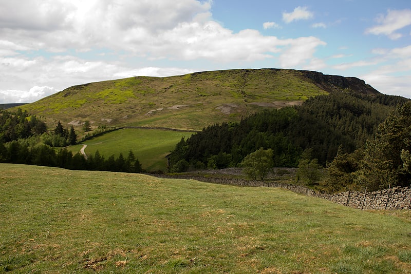
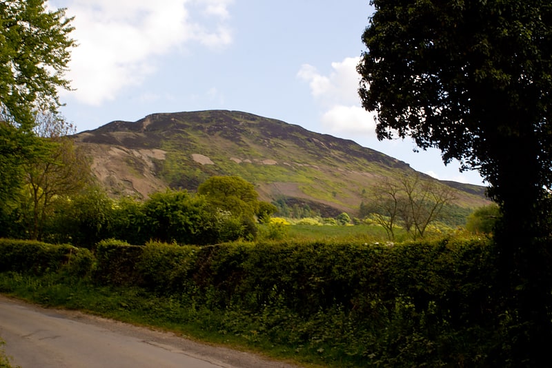
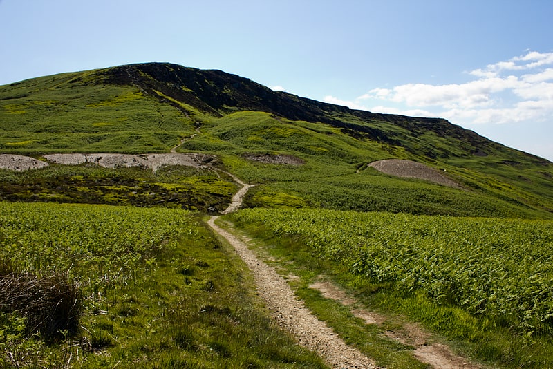
Roseberry Topping
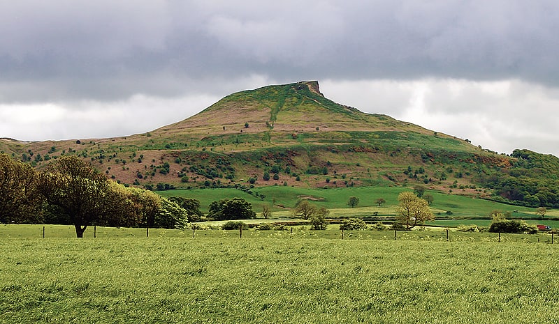
Hill in England. Roseberry Topping is a distinctive hill in North Yorkshire, England. It is situated near Great Ayton and Newton under Roseberry. Its summit has a distinctive half-cone shape with a jagged cliff, which has led to many comparisons with the much higher Matterhorn in the Swiss-Italian Alps. It forms a symbolic image of the area and features in the logo for the nearby Teesside International Airport.
At 1,049 feet (320 m), Roseberry Topping was traditionally thought to be the highest hill on the North York Moors; however, there are 15 higher peaks with the nearby Urra Moor being the highest, at 1,490 feet (450 m). Roseberry Topping offers views of Captain Cook's Monument at Easby Moor and the monument at Eston Nab, previously a beacon.[3]
Address: Ormesby Hall, TS7 9AS Redcar and Cleveland
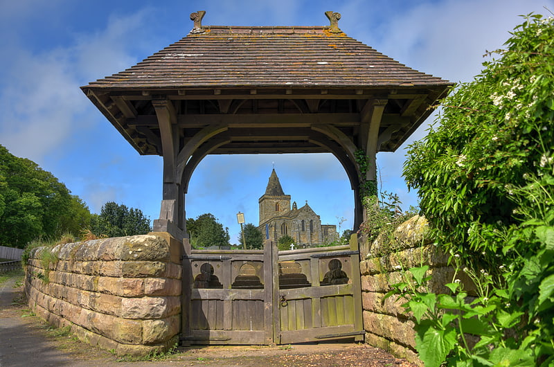
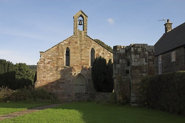
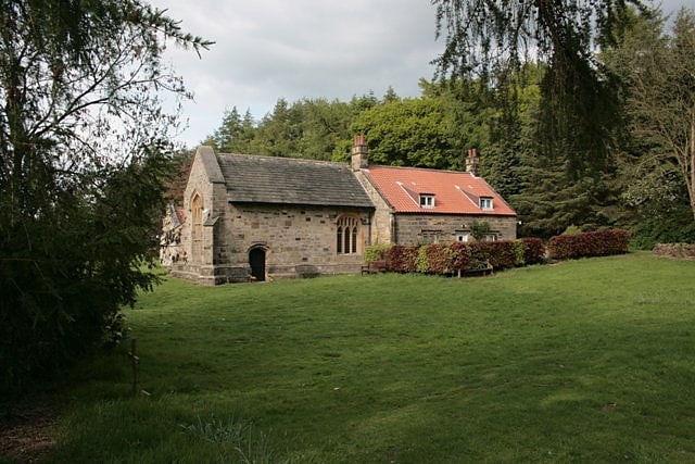
St Michael's Church
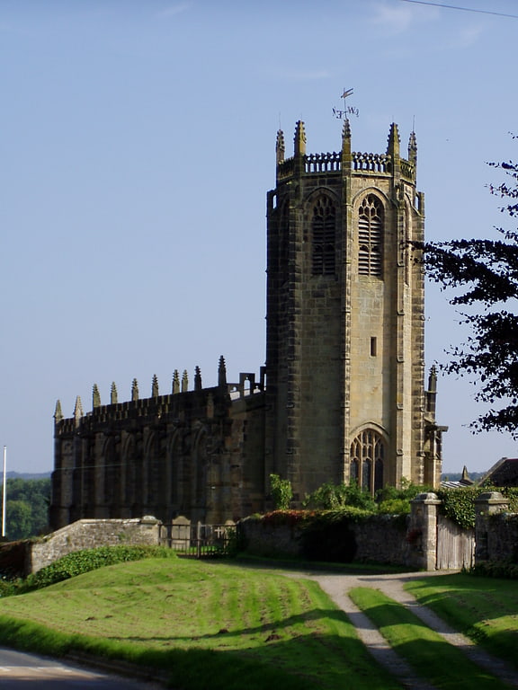
St Michael's Church is an Anglican parish church in Coxwold, North Yorkshire, England. The Parish of Coxwold is part of the Church of England's Diocese of York.
The earliest church on the site dates to the Anglo-Saxon period. That church was replaced by a Norman one built in the 11th century, and that in turn was replaced with the present church which was built by 1430. The church is in the Perpendicular style, and among its unusual features are an octagonal tower and a tongue-shaped altar rail. The church is a grade I listed building.[4]
Address: Thirsk Bank, YO61 4AD York
Mallyan Spout
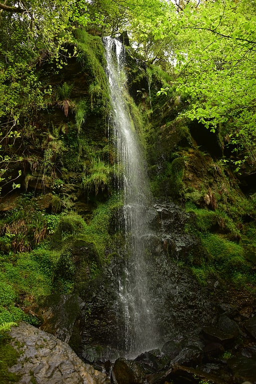
Tourist attraction in England. Mallyan Spout is a waterfall in North Yorkshire, England, the tallest waterfall in the North York Moors.[5]
Address: Common Road, YO22 5AN Goathland
Church of St Oswald
The Church of St Oswald, Lythe, is the parish church for the village of Lythe, 4 miles west, north west of Whitby in North Yorkshire, England. The church is at the top of Lythe Bank and is just east of the village on the A174 road.
A church has been on the site since the 13th century, though the present building was adapted from the old church in 1910 by Sir Walter Tapper. It was grade I listed in 1969.[6]
Helmsley Open Air Swimming Pool
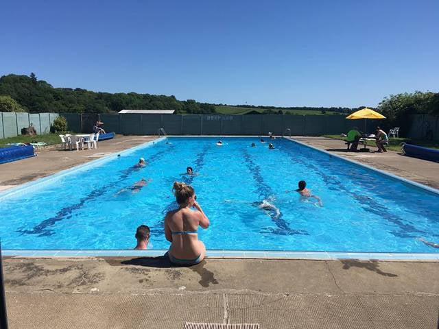
Watersports, Theme park, Amusement park, Swimming pool, Swimming
Address: Baxtons Lane, YO62 5HT North York Moors
Easby Moor
Hill in England. Easby Moor is a hill located in the civil parish of Little Ayton in the North York Moors national park within the Cleveland Hills, North Yorkshire, England. At the peak, at 324 metres above sea level, is a monument to Captain James Cook, who was native to the area. The Cleveland Way runs over the moor. The moor overlooks the villages of Easby and Great Ayton and Little Ayton.[7]
Cod Beck Reservoir
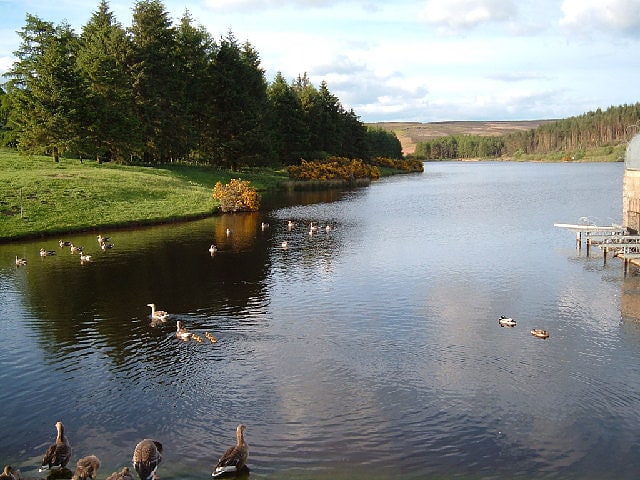
Lake in England. Cod Beck Reservoir is a man-made lake situated within the North York Moors National Park and near the village of Osmotherley in the English county of North Yorkshire. The reservoir is named after Cod Beck, which is the small river that fills it.[8]
Gormire Lake
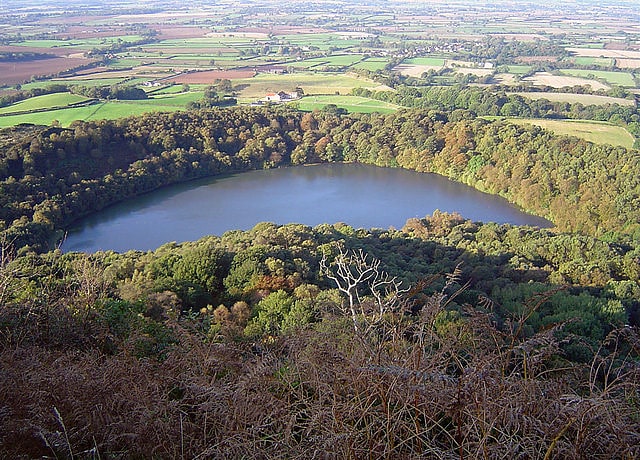
Lake in England. Gormire Lake is a natural lowland lake that lies at the foot of Whitestone Cliff, a western escarpment of the Hambleton Hills in the North York Moors National Park. The lake is 1.2 miles east of the village of Sutton-under-Whitestonecliffe in North Yorkshire, England. Gormire has no inflow or major outflow of water. It is thought to be fed by an underground spring and drained by a limestone channel so the water finds a way out through the base of the cliff face to the east of the lake. The lake is also known as the White Mere, Lake Gormire, or more simply, Gormire. The name Gormire translates as filthy swamp.
The lake was formed over 20,000 years ago by glacial erosion. When an ice sheet pushed its way between the Pennines and the North York Moors, it bulldozed the soft earth away and carved the cliffs at Whitestone and in turn the mud left over stopped the water's egress and formed the glacial lake. Gormire Lake was a result of this process and is fourth largest of the natural lakes in Yorkshire (the other three being Hornsea Mere, Malham Tarn and Semerwater). The lake was first designated as an Site of Special Scientific Interest (SSSI) in 1954; however, in 1985 the area surrounding the lake was incorporated into the SSSI status with the new area being 133.5 acres (54.03 ha). The new designation incorporates the broadleaf woodlands of Garbutt Wood which encroach right up to the water's edge.
The lake is the setting of several myths; one being of a knight known as Sir Harry Scriven who conned the Abbot of Rievaulx Abbey into letting him ride his horse (a white mare, the so called derivation of White Mare Cliff (another name for Whitestonecliff)). The knight and the abbot rode on from an inn and as they did so, it turned into a race. The abbot then changed into the devil, which caused such panic in the knight that he couldn't stop the horse and himself plunging into Gormire Lake from the clifftop. The 'devil' was then seen to jump into the lake after them and the boiling effect of the devil in the water is what is said to have caused the darkness of the lake to this day.
Other myths are that the lake is bottomless, that the bottom of the lake is the entrance to hell, there is submerged village underneath the water and that a goose once disappeared in the lake to emerge in a well at Kirkbymoorside stripped of all its feathers.
Gormire Lake is popular with wild swimmers as it has no streams feeding it so there is very little current and the waters are described as being 'warm'. Swimmers have reported that it is seething with leeches. The Times named the lake as one of the 20 best lakes and rivers in Britain for wild swimming.[9]
Whorlton Castle
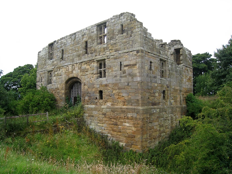
Historical landmark in England. Whorlton Castle is a ruined medieval castle situated near the abandoned village of Whorlton in North Yorkshire, England. It was established in the early 12th century as a Norman motte-and-bailey associated with the nearby settlement. The castle is an unusual example of a motte-and-bailey that remained in use throughout the Middle Ages and into the early modern period.
Built to overlook an important road on the western edge of the North York Moors, the castle fell into ruin as early as the mid-14th century. The site nonetheless continued to be inhabited until at least the early 17th century. Little now remains of the castle itself, other than the remnants of some cellars or undercrofts. The ruined shell of a 14th-century gatehouse still survives, albeit in fairly poor condition. It is a listed building and is privately owned but can be visited by the public.[10]
Sutton Bank
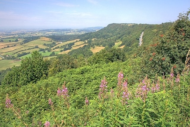
Hill in England. Sutton Bank is a hill in the Hambleton District of the North York Moors National Park, North Yorkshire in England. It is a high point on the Hambleton Hills with extensive views over the Vale of York and the Vale of Mowbray.
At the foot of Sutton Bank lies the village of Sutton-under-Whitestonecliffe; at 27 letters long, it has the longest hyphenated placename in England.
The A170 road runs down the bank with a maximum gradient of 1 in 4 (25%), and including a hairpin bend. Vehicles have to keep in low gear whilst travelling up or down the bank, and caravans are banned from using the section.[11]
Rosedale Priory
Priory. Rosedale Priory was a priory in Rosedale Abbey, North Yorkshire, England that was founded c. 1150–1199. By the time the priory was suppressed in 1535, it had one prioress and eight nuns. The religious house in Rosedale was a priory and not an abbey, despite the village being given the name Rosedale Abbey, and it is unclear why this came about.
The priory was founded during the reign of Henry II and finished during the reign of Richard the Lionheart. The land was donated by Robert de Stuteville, so that nuns from the Benedictine order could worship and farm the surrounding land.
After suppression during the reign of King Henry VIII, the priory was abandoned, though it is thought that most of the stones were re-used in the construction of the village buildings including the adjacent church of St Mary and St Lawrence. The only ruin left standing is a 13th-century turret which rises to 20 feet (6.1 m) high and is just to the west of the present church. The turret was grade II listed in 1953.[12]
Hasty Bank
Hill in England. Hasty Bank is a hill in the Cleveland Hills range of the North York Moors, in north-east England. The Cleveland Way National Trail crosses Hasty Bank and is part of Wainwright's Coast to Coast Walk. The north face of Hasty Bank has heavily eroded, possessing a vertical rocky face sloping steeply down to Broughton Bank. Roseberry Topping can be clearly seen from the summit which offers great views of the Tees Valley.
From the north, Hasty Bank is easily identified in line with Carlton Bank, Cringle Moor, Cold Moor, and Urra Moor which form the more northern facing hills of the range, before sweeping north to become the west facing hills up towards Roseberry Topping.[13]
Carlton Bank
Hill in England. Carlton Bank is a hill in the Cleveland Hills, in north-east England. It is located on Carlton Moor in the North York Moors and overlooks the villages of Carlton-in-Cleveland and Faceby. The summit provides extensive views of Teesside including Middlesbrough and Redcar to the north as well as the surrounding moorland. Roseberry Topping can also be clearly seen from the summit in a north-easterly direction. The Cleveland Way National Trail crosses Carlton Bank and is part of Wainwright's Coast to Coast Walk.
A gliding club aerodrome was once situated approximately 500 metres (1,640 ft) south of the summit.[14]
Cringle Moor
Hill in England. Cringle Moor, at 432 m, is the third highest hill in the North York Moors, England, and the highest point west of Clay Bank.
The hill is crossed by the Cleveland Way National Trail and is a part of Wainwright's Coast to Coast Walk, which also passes over the neighbouring tops of Cold Moor, Carlton Moor, Live Moor and Hasty Bank — a section of the walk which Alfred Wainwright described as "one of the finest". It is also part of the Lyke Wake Walk.
Just to the west of the summit is the burial mound of 'Drake Howe (Howe is an Old Norse word meaning burial mound). This is a Bronze Age burial mound that is now a scheduled ancient monument.[15]
Mulgrave Castle
Historical landmark in England. Mulgrave Castle refers to one of three structures on the same property in Lythe, near Whitby, North Yorkshire, England. One of these, known as the "old" or "ancient" castle, was by legend founded by Wada, a 6th-century ruler of Hälsingland. The second castle, (54.4935°N 0.7055°W / 54.4935; -0.7055) caput of the feudal barony of Mulgrave, was of Norman construction and remained active until destroyed by order of Parliament in 1647. The third is a country house (54.5012°N 0.6922°W / 54.5012; -0.6922 which was constructed by Lady Catherine Darnley and passed in 1718 by marriage into the Phipps family, when her daughter Lady Catherine Annesley married William Phipps. The Phipps family later held the titles of Baron Mulgrave, Earl of Mulgrave and Marquess of Normanby.[16]
The Shrine of Our Lady of Mount Grace
The Shrine of Our Lady of Mount Grace is a place of Marian devotion and pilgrimage sited in the North Yorkshire village of Osmotherley. Christians have visited this small church, known as the “Lady Chapel”, for centuries and continue the tradition through an annual pilgrimage every summer on the Sunday nearest the Feast of the Assumption, 15 August.[17]
Wade's Causeway
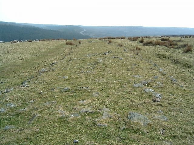
Monument. Wade's Causeway is a sinuous, linear monument up to 6,000 years old in the North York Moors national park in North Yorkshire, England. The name may refer to either scheduled ancient monument number 1004876—a length of stone course just over 1 mile long on Wheeldale Moor, or to a postulated extension of this structure, incorporating ancient monuments numbers 1004108 and 1004104 extending to the north and south for up to 25 miles. The visible course on Wheeldale Moor consists of an embankment of soil, peat, gravel and loose pebbles 0.7 metres in height and 4 to 7 metres in width. The gently cambered embankment is capped with unmortared and loosely abutted flagstones. Its original form is uncertain since it has been subjected to weathering and human damage.
The structure has been the subject of folklore in the surrounding area for several hundred years and possibly more than a millennium. Its construction was commonly attributed to a giant known as Wade, a figure from Germanic or Norse mythology. In the 1720s, the causeway was mentioned in a published text and became known outside the local area. Within a few years, it became of interest to antiquarians who visited the site and exchanged commentary on its probable historicity. They interpreted the structure as a causeway across the marshy ground, attributing its construction to the Roman military, an explanation largely unchallenged throughout the eighteenth and nineteenth centuries.
The stretch of the causeway on Wheeldale Moor was cleared of vegetation and excavated in the early twentieth century by a local gamekeeper interested in archaeology. The historian Ivan Margary agreed with its identification as a Roman road and assigned it the catalogue number 81b in the first edition of his Roman Roads In Britain (1957). The causeway was further excavated and studied by the archaeologist Raymond Hayes in the 1950s and 1960s, partly funded by the Council for British Archaeology. The results of his investigation concluded that the structure was a Roman road and were published in 1964 by the Scarborough Archaeological and Historical Society.
In the late twentieth and early twenty-first centuries, its identification as a Roman road has been questioned by academics, and alternative interpretations suggested for its purpose and date of construction. The monument's co-manager, English Heritage, in 2012, proposed several avenues of research that might be used to settle some of the questions that have arisen regarding its origins and usage.[18]
Newton Dale
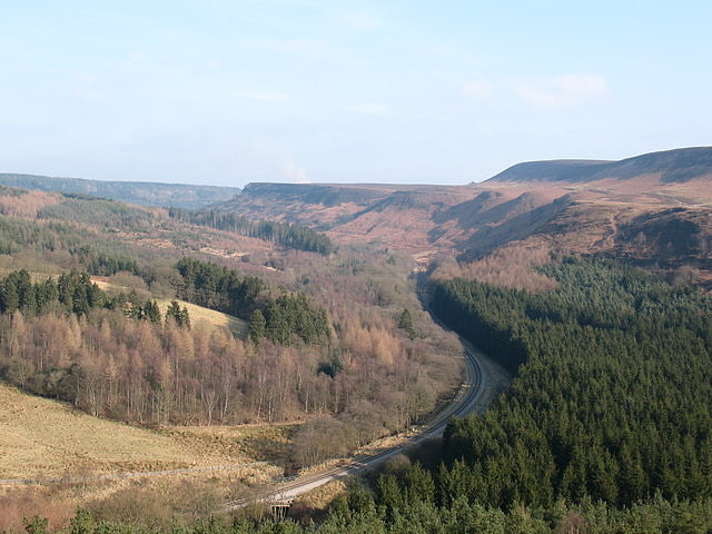
Newton Dale is a narrow dale within the North York Moors National Park in North Yorkshire, England. It was created by meltwater from a glacier carving the narrow valley. Water still flows through the dale and is known as Pickering Beck.
The dale starts between Goathland Moor and Lockton High Moor where water runs southwards towards Pickering. In its upper reaches, the dale is very twisting and deep with the floor of the dale being 490 feet (150 m) above sea level.
The dale is spelt either Newtondale or Newton Dale. Ordnance Survey maps and the North York Moors Railway refer to it as Newton Dale.[19]