Discover 35 hidden attractions, cool sights, and unusual things to do in Derby (United Kingdom). Don't miss out on these must-see attractions: Derby Museum and Art Gallery, Stenson Marina, and Derby Cathedral. Also, be sure to include Donington Park in your itinerary.
Below, you can find the list of the most amazing places you should visit in Derby (England).
Table of Contents
Derby Museum and Art Gallery
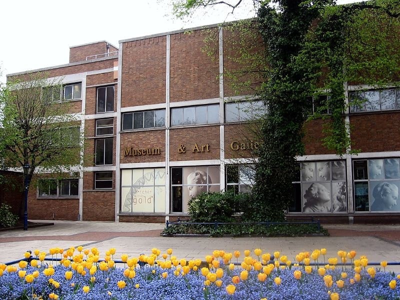
Diverse collections and exhibits for free. Derby Museum and Art Gallery is a museum and art gallery in Derby, England. It was established in 1879, along with Derby Central Library, in a new building designed by Richard Knill Freeman and given to Derby by Michael Thomas Bass. The collection includes a gallery displaying many paintings by Joseph Wright of Derby; there is also a large display of Royal Crown Derby and other porcelain from Derby and the surrounding area. Further displays include archaeology, natural history, geology, military collections and world cultures. The Art Gallery was opened in 1882.[1]
Address: The Strand, DE1 1BS Derby
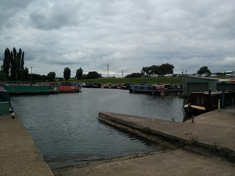
Stenson Marina
English civil parish. Twyford and Stenson is a civil parish in the South Derbyshire district of Derbyshire, England. Located south of Derby on the Trent and Mersey Canal, it consists of two villages, Stenson and its smaller neighbour Twyford.
Between Stenson and Derby itself lies the busy A50 dual-carriageway and Stenson Fields, a large housing estate built between the early 1970s and late 1990s. Stenson Fields is constituted as a separate parish wholly within South Derbyshire District, but it is essentially contiguous with the Sunny Hill, Sinfin and Littleover suburbs of Derby city. The parish of Stenson Fields was created in 1983 from parts of the parish of Barrow-upon-Trent and the parish of Twyford and Stenson. Originally called Sinfin Moor the name was later changed to Stenson Fields to be in keeping with the geographical and historical place name of the area. Sinfin Moor is a large tract of land to the east of Stenson Fields and Sinfin proper. Sinfin Moor is a Regionally Important Geological Site (RIGS) which formed over the bed of an ice age lake. Part of the RIGS spills over into Stenson Fields close to the hamlet of Arleston. In 2017, South Derbyshire District Council described Twyford and Stenson as an "unparished area" when it approved the transfer of a further 197 acres from it to Stenson Fields parish. In 2020, Twyford and Stenson does not appear to have a parish council.
Stenson Lock is lock number 6. It is the second deepest on the canal at 12' 6". There is also a marina and a narrowboat builders. The 'Stenson Bubble', after which the local waterside pub is named, is due to the sound, and actual bubbles, the overflow stream to the south of the lock makes as it emerges forcefully into the canal below the lock through a culvert at the same level, or sometimes below, the canal surface itself.
A railway line follows the line of the canal, part of a loop for freight bypassing Derby. This runs from the nearby Stenson Junction on the Derby-Birmingham line to Sheet Stores Junction at Sawley on the Midland Main Line.[2]
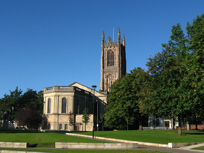
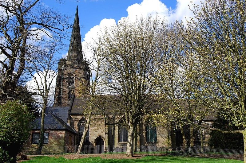
Derby Cathedral
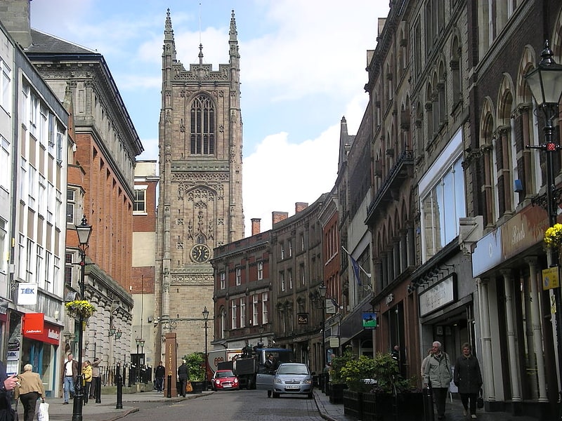
Place of worship with 16th-century tower. The Cathedral Church of All Saints Derby, better known as Derby Cathedral, is a cathedral church in the city of Derby, England. In 1927, it was promoted from parish church status, to a cathedral, creating a seat for the Bishop of Derby, which new see was created in that year. The original church of All Saints was founded in the mid-10th century as a royal collegiate church, dedicated to All Saints. The main body of the church as it stands today is a Georgian rebuilding by James Gibbs, completed in 1725. The tower dates from the 16th century, and a retroquire was added in the 20th century.[3]
Address: 18-19 Iron Gate, DE1 3GP Derby
Donington Park
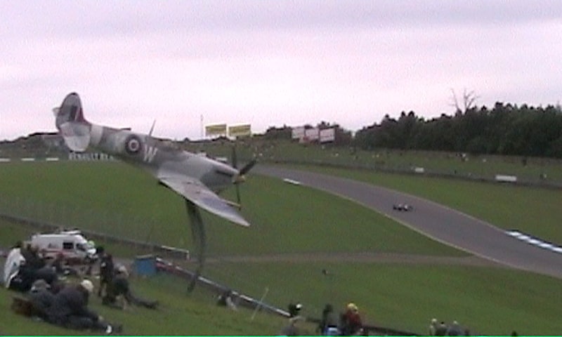
Popular track with hairpins and inclines. Donington Park is a motorsport circuit located near Castle Donington in Leicestershire, England. The circuit business is now owned by Jonathan Palmer's MotorSport Vision organisation, and the surrounding Donington Park Estate, still owned by the Wheatcroft family, is currently under lease by MotorSport Vision until 2038. It has a capacity of 120,000.
Originally part of the Donington Hall estate, it was created as a racing circuit during the period between the First and Second World Wars when the German Silver Arrows were battling for the European Championship. Used as a military vehicle storage depot during the Second World War, it fell into disrepair until bought by local construction entrepreneur Tom Wheatcroft. Revived under his ownership in the 1970s, it hosted a single Formula One race in 1993, but became the favoured home of the British round of the MotoGP motorcycling championship.
Leased by Donington Ventures Leisure Ltd in 2007 the hope that Formula One racing could return to the track, the incomplete venture failed to raise sufficient financial backing during the aftermath of the 2008 global financial crisis. DVLL consequently lost the rights to the British rounds of both Formula 1 and MotoGP, and in its bankruptcy returned the track to the Wheatcroft family in December 2009.
Under Wheatcroft's ownership, the venue underwent significant work, with the track restored to use in autumn 2010, before major upgrades in the following five years. At the end of 2010, it was announced that Donington would become home to an annual historic motorsport event, the Donington Historic Festival, with new events constantly being added. Since 2010, significant investment across the venue has seen major improvements made to its infrastructure, while the circuit has become a regular fixture for top class motorcycling in the form of the Superbike World Championship.
In January 2017, the circuit business and a long-term lease on the estate was purchased by MotorSport Vision, with the purchase cleared by authorities in August of the same year. Significant investment has seen facilities at the venue brought up to modern standards, with a new restaurant, toilet blocks, large new grandstand and new circuit offices, as well as other detail changes. As well as improving the infrastructure, MSV made additions to the race calendar, with additional major events planned for 2019 which included extra rounds of the British Superbike Championship and British GT.[4]
Address: Donington Park Race Circuit Donington Park, DE74 2RP Derby
County Cricket Ground
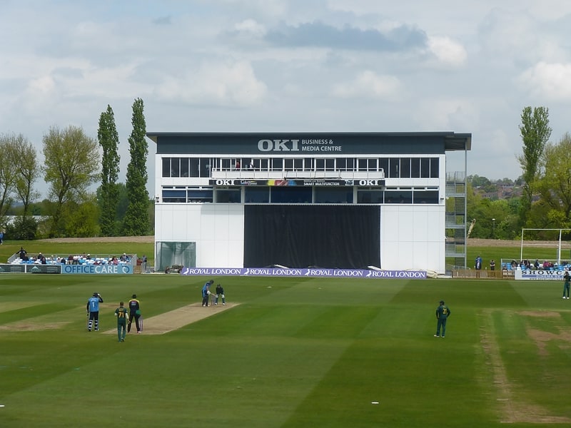
Sports venue. The County Cricket Ground is a cricket ground in Derby, England. It has been the home of Derbyshire County Cricket Club since 1871. The ground was first used by South Derbyshire Cricket Club in 1863 and was initially located within Derby Racecourse, although racing ceased after 1939. The ground has staged two One-Day Internationals: New Zealand against Sri Lanka during the 1983 ICC Cricket World Cup and New Zealand against Pakistan during the 1999 ICC Cricket World Cup. It was one of the venues for the 2017 ICC Women's Cricket World Cup, hosting one of the semi-finals.
The ground was also formerly used for football, and was the home of Derby County F.C. between 1884 and 1895. It staged the first ever FA Cup Final match played outside London, a replay of the 1886 Final, and hosted an international match between England and Ireland in 1895.[5]
Address: The County Ground Nottingham Road, DE21 6DA Derby
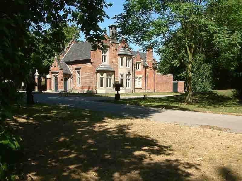
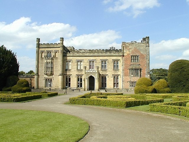
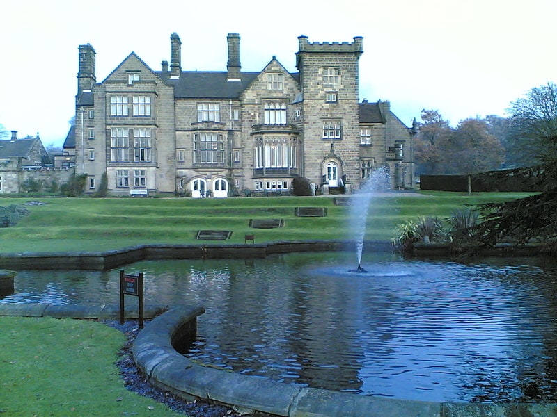
Kedleston Hall
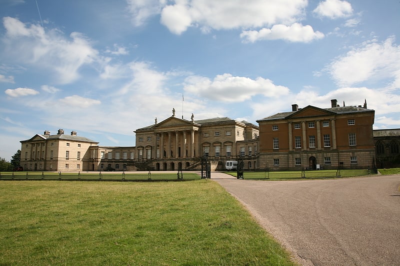
Neoclassical mansion in vast parkland. Kedleston Hall is a neo-classical manor house, and seat of the Curzon family, located in Kedleston, Derbyshire, aprox 4 miles north-west of Derby. The medieval village of Kedleston was demolished in 1759 by Nathaniel Curzon to make way for the manor. All that remains of the original village is the 12th century All Saints Church, Kedleston. Members of the family have held 14 hereditary titles such as: Marquess Curzon of Kedleston, Earl Howe, Earl Curzon of Kedleston, Viscount Curzon, Viscount Scarsdale, Viscounts Howe, Curzon of Kedleston, Baron Scarsdale, Baron Ravensdale, Manor of Curzon, Baron Howe, Baron Curzon, Baronet Mosley, and Baronet Kedleston Hall.[6]
Address: Derby, DE22 5JH, Derby
St Mary's Bridge Chapel
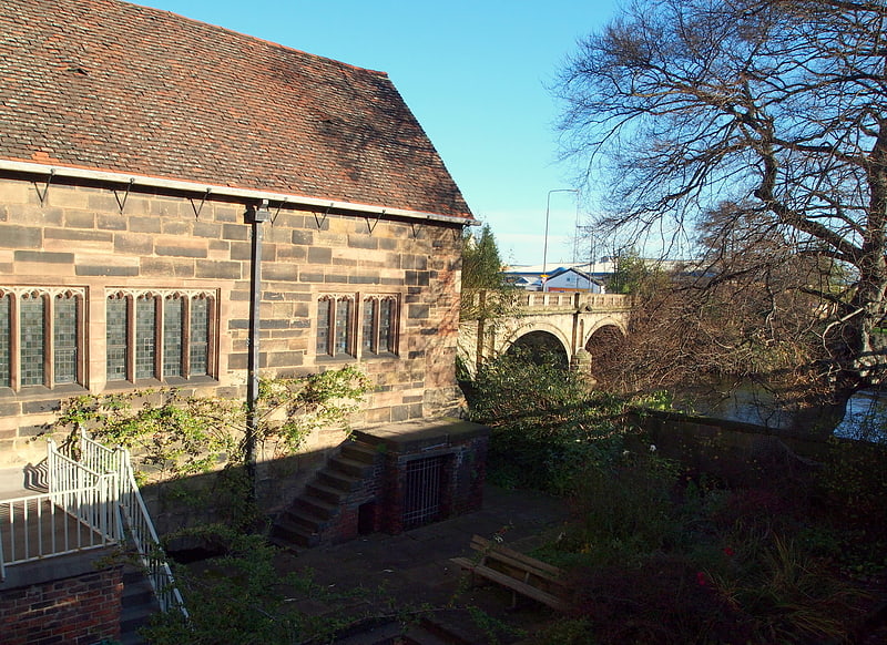
St Mary's Bridge Chapel is a Church of England chapel in Derby, England. It is a bridge chapel, one of only a small number of medieval age that survive in England. It is a Grade I listed building.
The Chapel of St Mary on the Bridge, commonly known as the Bridge Chapel, was built on the first arch of a medieval bridge over the River Derwent; the springing of the arch can be seen below the east wall. It now stands beside the 18th-century St Mary's Bridge, which replaced the medieval bridge.
The precise date when the first bridge chapel came into existence is uncertain, but it is likely to have been the late 13th or early 14th century. The south elevation has a timber-framed gable over a 15th-century stone-mullioned window with modern leaded lights. The original building was of stone, but some restoration is in brick with tile slips. The interior is small and aisleless. The north wall has a lychnoscope.
It is one of only six bridge chapels left in England. The building has had other uses including as a prison and a carpenter's workshop. It was restored in 1930 in memory of Alfred Seale Haslam, a former Mayor of Derby, using funds from his family.
An incised slate tablet on the north side records the names of three Catholic priests, Nicholas Garlick, Robert Ludlum and Richard Simpson, who on 24 July 1588 were martyred near here.
Although it remains in Anglican ownership, the building is also used for worship by Lutheran (Latvian and German-speaking) and Russian Orthodox congregations.
The adjacent St Mary's Bridge (1788–93, designed by Thomas Harrison) is a Grade II* listed structure and scheduled monument, and Bridge Chapel House (or St Mary's Bridge House, No. 86) is listed at Grade II.[7]
Address: 2 St Mary's Ct, Duke St, DE1 3DD Derby
Pride Park Stadium
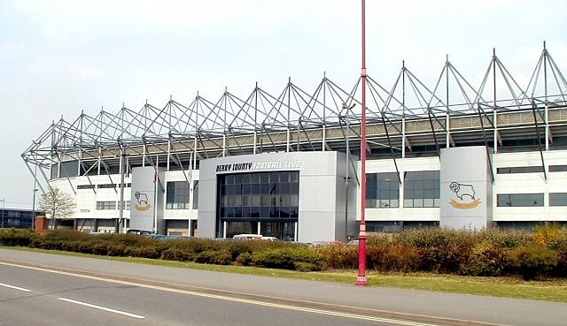
Stadium in Derby, England. Pride Park Stadium is an all-seater football stadium in Derby, England, that is the home ground of English Football League club Derby County. With a capacity of 33,597, it is the 16th-largest football ground in England and the 20th-largest stadium in the United Kingdom. Located on Pride Park, a business park on the outskirts of Derby city centre, the stadium was built as part of the commercial redevelopment of the area in the 1990s. Derby County have played at the ground since it opened in 1997 as a replacement for their former home, the Baseball Ground. Due to sponsorship, the venue was officially known as the iPro Stadium between 2013 and 2016.
Pride Park has hosted two full international matches, England v. Mexico in 2001 and Brazil v. Ukraine in 2010, and several England under-21 matches. It was also the venue of the 2009 FA Women's Cup Final.[8]
Address: Pride Park, DE24 8XL Derbyshire
Darley Park
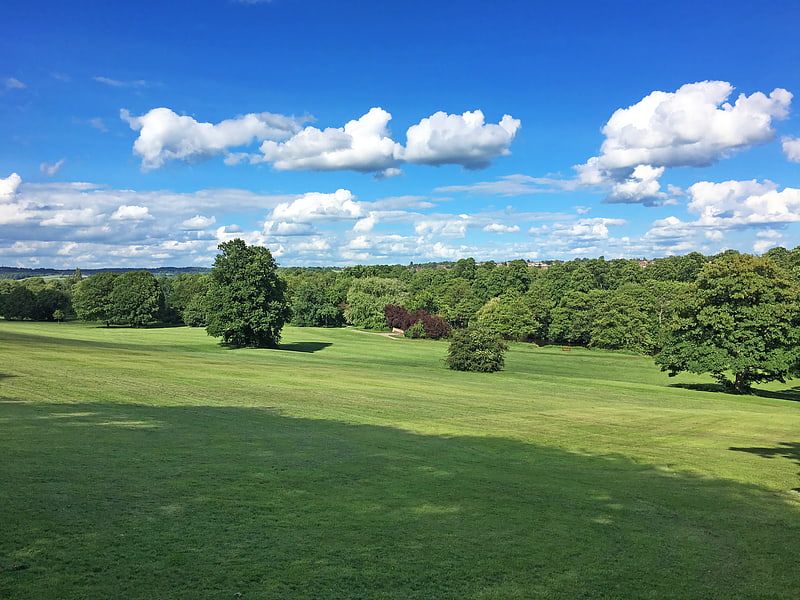
Darley Park is an urban park on the banks of the River Derwent, just north of Derby City Centre, England, United Kingdom. It has a total area of 80 acres and forms the largest part of the Darley Open Spaces. The park is one of Derby's most popular outdoor spaces.[9]
Address: Abbey Yard, DE22 1DS Derby
QUAD
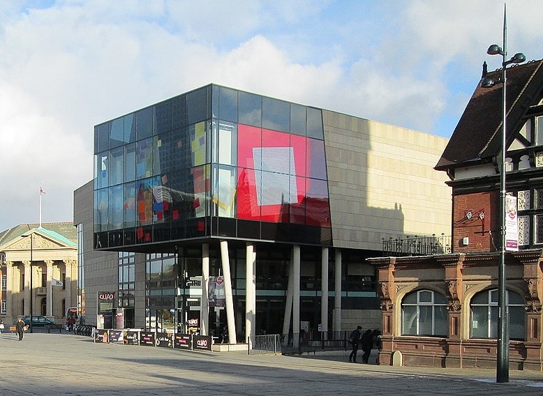
Cafe. Quad, is an arts centre in Derby, England, first opened on 26 September 2008. Quad provides an art gallery, three cinemas, artists’ studios, and a cafe bar. The centre also has available spaces in which people can create their own artwork.
The building has a steel-and-glass design by Bath architects Feilden Clegg Bradley, which was considered controversial when it was chosen by Derby council cabinet in 2004.[10]
Address: Derby, Market Place, Derby, DE1 3AS
Derby Arboretum
The first public park in Britain. Derby Arboretum is a public park and arboretum in the city of Derby, England, located about 1 mile south of the city centre in the Rose Hill area. It was opened in 1840, following the donation of the land by local philanthropist Joseph Strutt, and to designs by John Claudius Loudon. It was the first publicly owned, landscaped, urban, recreational park in England. After many years of neglect, the Arboretum was extensively refurbished in the early 21st century with the aid of a Heritage Lottery Fund grant of almost £5 million. It is listed as Grade II* on the English Heritage Register of Parks and Gardens of Special Historic Interest in England.[11]
Address: 12 Arboretum St, DE23 8FN Derby
Exeter Bridge
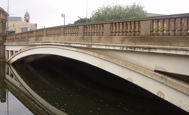
Concrete bridge in Derby, England. Exeter Bridge is a bridge in the centre of Derby spanning the River Derwent 200 metres south of the more modern Cathedral Green Footbridge.[12]
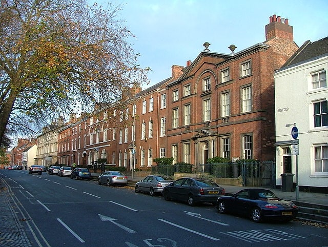
Cathedral Quarter
The Cathedral Quarter is one of five areas within Derby city centre, based around the name of the Cathedral. It is bound by St Alkmund's Way and Ford Street to the north and west, the River Derwent to the east, and Albert Street, Victoria Street, Wardwick and Friargate to the south. It is a shopping, business, retail and cultural quarter, containing many key arts and tourist venues. These include Derby Museum and Art Gallery, Derby Central Library, Derby Local Studies Library, The Silk Mill, Déda, The QUAD, The Assembly Rooms, The Guildhall, Derby Tourist Information centre and, of course, Derby Cathedral. The Silk Mill is at the start of the Derwent Valley World Heritage Site, marking the city's important role in the birth of the Industrial Revolution. Many outdoor events take place within The Cathedral Quarter, mostly centred on The Market Place or Cathedral Green.[13]
All Saints Church
All Saints' Church, Kedleston, is a redundant Anglican Church approx. 4 miles north-west of Derby, and all that remains of the medieval village of Kedleston, demolished in 1759 by Nathaniel Curzon to make way for the adjacent Kedleston Hall, a country house in Derbyshire, England. It is recorded in the National Heritage List for England as a designated Grade I listed building. Kedleston Hall is owned by the National Trust, and the church is under the care of the Churches Conservation Trust. Kedleston Hall has been occupied by the Curzon family for over 700 years.[14]
Guildhall Theatre
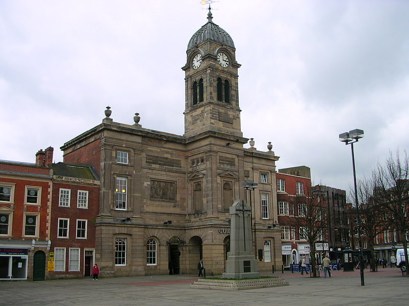
Derby Guildhall is a municipal building in the Market Place, Derby, England. It is a Grade II listed building.[15]
Address: Market Place, DE1 3AE Derbyshire
Lombe's Mill
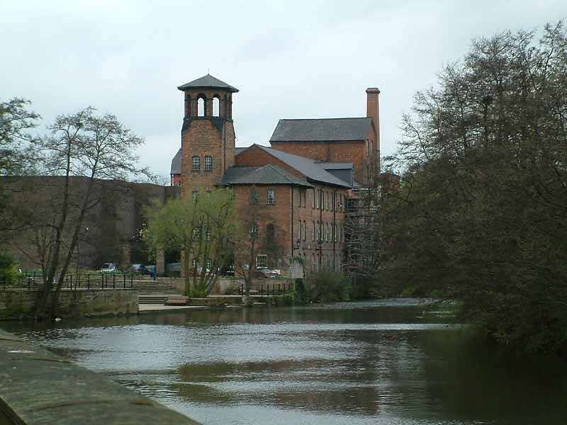
Lombe's Mill was the first successful silk throwing mill in Britain. It was built on an island on the River Derwent in Derby. It was built after John Lombe visited Piedmont in 1717 and returned to England with details of the Italian silk throwing machines – the filatoio and the torcitoio – and some Italian craftsmen. The architect was George Sorocold. At its height, the mill employed some 300 people.[16]
Elvaston Castle
Stately home in England. Elvaston Castle is a stately home in Elvaston, Derbyshire, England. The Gothic Revival castle and surrounding parkland is run and owned by Derbyshire County Council as a country park known as Elvaston Castle Country Park. The country park has 200 acres of woodlands, parkland and formal gardens.
The centrepiece of the estate is the Grade II* Listed Elvaston Castle. The castle has been neglected and is in need of restoration. Due to its condition, the building is not open to the public, and since 2008 has been listed on the Buildings at Risk Register. Derbyshire County Council estimates the castle and estate requires significant investment for both restoration and to support its longer-term maintenance. In 2017 The Elvaston Castle and Gardens Trust was created to manage the estate once these works, which are already underway, are completed.[17]
Address: Borrowash Rd., DE72 3EP Elvaston
Derby Theatre
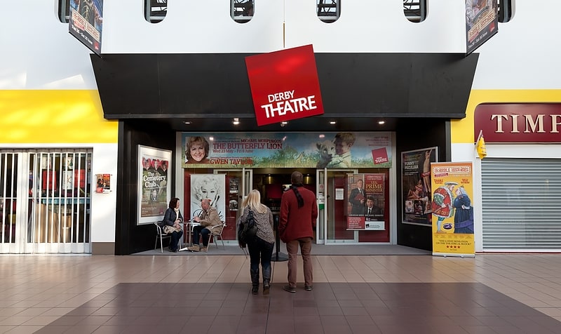
Theatre in Derby, England. Derby Theatre is a theatre situated in Derby, England, located within the Derbion shopping centre. Formerly known as the Derby Playhouse, it was owned and run by Derby Playhouse Ltd from its opening in 1975 until 2008, when the company ceased operating after a period in administration. The theatre was reopened in 2009 as the Derby Theatre under the ownership of the University of Derby, who use it as a professional and learning theatre. In addition to the 531 seat main auditorium, the building contains a 110-seat studio theatre.[18]
Address: westfield market, DE1 3AH Derby
Allestree Hall
Building in Derby, England. Allestree Hall is a 19th-century former country house situated in Allestree Park, Allestree, Derby. It is a Grade II* listed building but has been unoccupied for many years, and has been placed on the Heritage at Risk Register.
The Mundy family owned the Manor of Allestree from 1516 until Francis Noel Clarke Mundy sold it to Thomas Evans in 1781. It was later the home of William Evans and of his son Sir Thomas William Evans, 1st Baronet. On his death in 1892 the latter bequeathed the estate to his brother in law William Gisborne.
The area known as Allestree Park was enclosed in about 1818. The house begun by Bache Thornhill was completed by John Giradot (High Sheriff of Derbyshire) with three storeys and five bays, the central three bowed with an ionic columned porch.
A large part of the estate was sold for housing development in 1928. The neglected house now stands in a 300-acre (1.2 km2) wooded parkland with lake, grasslands and golf course, owned by Derby City Council. Allestree Park is designated as a Local Nature Reserve.[19]
Alvaston
Alvaston is a village and ward of Derby, England. Alvaston is situated on the A6, three miles south-east of Derby city centre and probably owes its name to Allwald. It is bordered to the north by the wards of Derwent, Chaddesden and Spondon, to the west is the City Centre, to the south are Sinfin and Chellaston and to the east the district of South Derbyshire.
The village of Alvaston has existed since at least the eleventh century. Rapid expansion came in the second half of the 19th Century and in 1904 the electric tram replaced the horse-bus service and, with the advent of the motor car, London Road became the A6. It became part of Derby in the late twentieth century.
The smaller, neighbouring village of Boulton has been swallowed up by Alvaston, and Boulton is rarely referred to by name.[20]
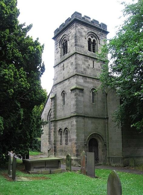
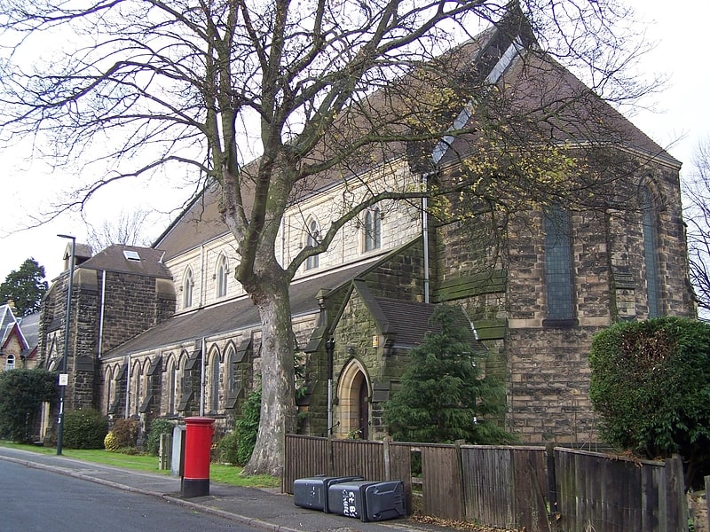
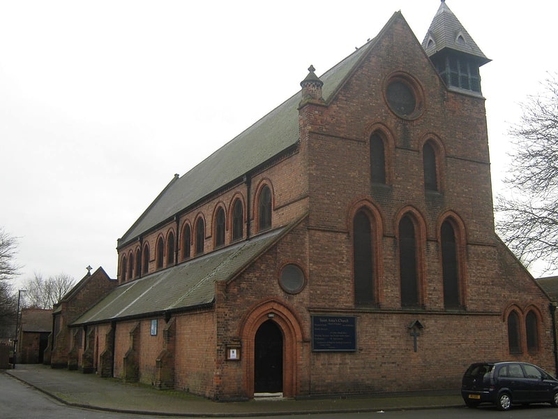
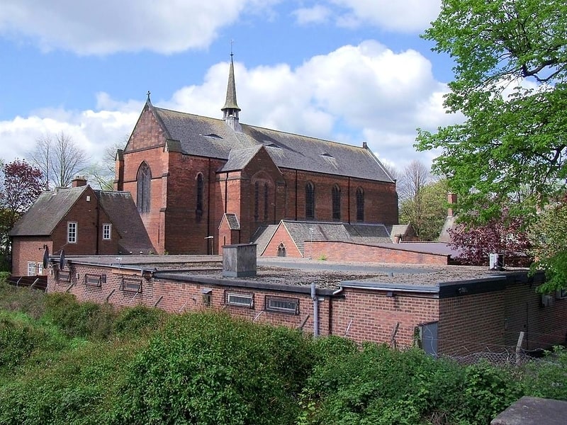
St John the Evangelist's Church
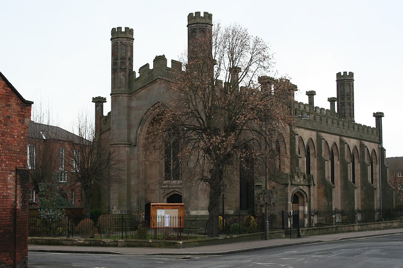
Church in Derby, England. St John the Evangelist's Church, Derby is a Grade II* listed parish church in the Church of England in Derby.[21]
Address: Mill St, DE1 3HZ Derby
Darley Abbey
Darley Abbey is a former historic mill village, now a suburb of the city of Derby, England. It is located approximately 1.4 miles north of the city centre, on the west bank of the River Derwent, and forms part of the Darley ward along with Little Chester and the West End. The settlement dates back to the medieval era, when it was the site of an Augustinian monastery. In the 18th century, the Evans family developed their planned industrial mill village in the area; Darley Abbey is now part of the Derwent Valley Mills World Heritage Site.
The area has been a part of the city (originally borough) of Derby since 1968 and is counted as part of Darley Ward.[22]
Derby War Memorial
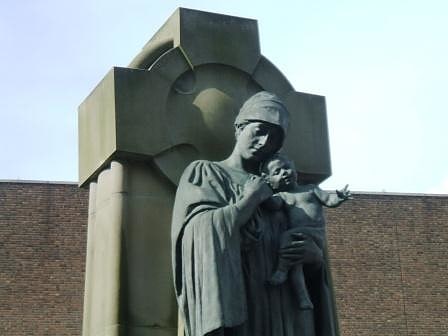
Historical landmark in Derby, England. The Derby War Memorial was designed by Charles Clayton Thompson and stands before the Derby Guildhall. It features a bronze figure of the Virgin Mary holding the baby Jesus in her arms by the sculptor George Arthur Walker. It was completed in 1924 and unveiled on 11 November 1924. Behind this bronze figure is a large Celtic cross. The memorial was erected to commemorate the fallen of The Great War with the inscription "The Great War/1914-1918".
A later inscription, "For Faith/And Home/And Righteousness/World War 1939–1945", was added to recognize those men of Derby who died in the Second World War.
A plaque commemorates the victims of later conflicts.[23]
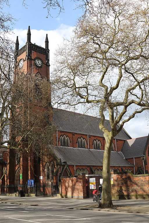
St Peter's Church
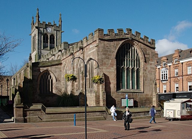
Anglican church in Derby, England. St Peter's in the City is a Church of England parish church in the city of Derby, UK. It is one of Derby's city centre churches which is in full use for worship. The church building dates from the 11th century. The tower has a peal of eight bells, which are rung before the Sunday morning services.
The church and its boundary walls were awarded Grade II* listed status in 1952.[24]
Address: St. Peters Street, DE1 1SN Derby
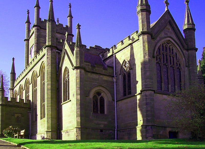
St Paul's Church
Episcopal church in Little Eaton, England. St Paul's Church, Little Eaton is a Grade II listed parish church in the Church of England in Little Eaton, Derbyshire.[25]
Address: Vicarage Ln, DE21 5EA Derby
Cathedral Green Footbridge
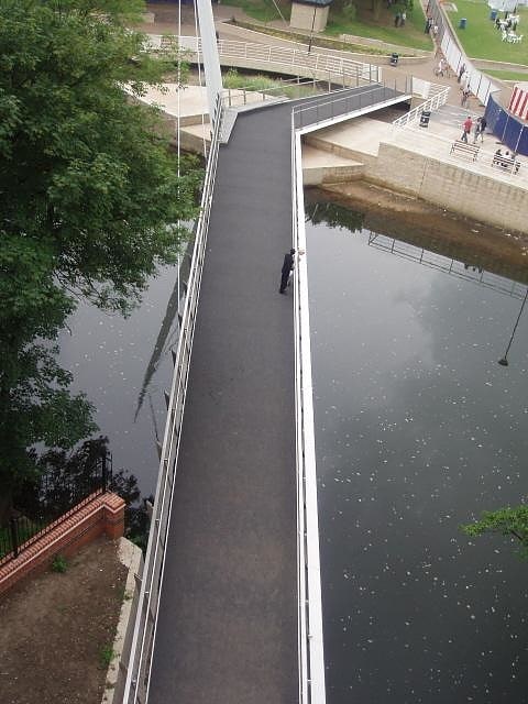
Bridge. The Cathedral Green Footbridge is a pedestrian and cycle swing bridge in the centre of Derby, spanning the River Derwent. It forms a third side to a triangle between The Cathedral and the Silk Mill Museum.
The bridge and adjacent re-landscaped Cathedral Green opened in March 2009 at a cost of £4.2m and is located in an area of World Heritage status. It links the Cathedral Green to Stuart Street and has been designed to swing to one side when water levels are high. It weighs 95 tonnes, with a box steel section deck, supported by three cables, keeping the overall structural slender. The bridge swings on a pintle bearing, with a central wheel to support its weight.
Construction began in August 2007 and the Bridge opened to the public on 20 March 2009, then was officially opened on 2 April 2009, a year behind schedule, by the Mayor of Derby. The bridge, designed by Ramboll, was partly inspired by tailor's shears and has an iconic needle-shaped mast, to echo the heritage of the nearby Silk Mill. The silk theme of the needle is complemented by the nearby Saint Alkmunds Way Footbridge which includes silk bobbins as its design feature.
The Cathedral Green has landscaped gardens with a tiled pavement incorporating lighting effects, called The Mill Flume, designed by Nayan Kulkarni, representing the path the river took when it powered the waterwheel of the Silk Mill. There is a statue of Bonnie Prince Charlie, as he was billeted near the site of the bridge during the Jacobite rising in December 1745.
The bridge was a finalist in the Prime Minister's Award for better public buildings following its completion in 2009. The judges said they were impressed by the design allowing the bridge to be turned with only a small amount of energy. The bridge, with its 38 degree kink, is supported on the central wheel with a wheel system being used on the counterweighted section.[26]
The Friary
Priory. Derby Black Friary, also known as Derby Dominican Priory, or Blackfriars, Derby, was a Dominican priory situated in the town of Derby, England. It was also named in different sources as a friary, monastery and convent, but was officially a priory as it was headed by a prior. The "Black" came from the colour of the robes worn by the friars of the order.
The friary was founded in the 13th century and enjoyed both royal patronage and royal visitors until its dissolution in 1539. It was constructed just outside the old town walls of Derby, on the site currently occupied by a house known as "The Friary" (formerly a hotel and currently a nightclub) on Friar Gate, just south of where Ford Street becomes Stafford Street. The priory was one of three in the immediate vicinity: a community of Benedictine nuns lived at The Priory of St Mary De Pratis (also known as King's Mead Priory), just under a quarter of a mile to the north-west; a community of Cluniac monks lived at St. James Priory (also known as Derby Cluniac Priory), just over a quarter of a mile to the south-east.[27]
Address: Friar Gate, DE1 1FG Derbyshire
St Werburgh's Church
Parish church in Derby, England. St. Werburgh's Church, Spondon, is a parish church in the Church of England located in Spondon, Derbyshire.[28]
Address: Gascoigne Dr, Derby
St Barnabas' Church
Church in Derby, England. St Barnabas' Church, Derby is a Church of England parish church in Derby, Derbyshire.[29]
Address: Radbourne St, DE22 3HD Derby
Holy Trinity Church
Holy Trinity Church, Derby is a Locally listed former Church of England parish church on London Road in Derby.[30]
Address: 117 London Rd, DE1 2QS Derby
Breadsall Priory
Priory. Breadsall Priory is a former Augustinian priory in Derbyshire, situated around two kilometres north of Breadsall, and two kilometres east of Little Eaton. The priory was established before 1266 by a member of the Curzon family. Only a small priory, Breadsall was dissolved in 1536.
Following dissolution the priory was demolished and a private home, also known as Breadsall Priory, built on the site; the house was altered and extended in both the 19th and 20th centuries, and only a single arch remains of the monastic buildings. The house and its stables are both Grade II Listed. The house is currently used as a hotel, while its stables are in residential use.[31]
Address: Moor Road, Derby
St. James Priory
Monastery. St. James Priory, also known as Derby Cluniac Priory, was a Benedictine monastery, formerly located in what is now Derby City Centre. It existed until the Dissolution of the Monasteries.[32]
St Anne's Church
Church in Derby, England. St Anne's Church, Derby is a Grade II* listed Church of England parish church in Derby.[33]
Address: 23 St John's Terrace, DE1 3NE Derby
St Osmund's Church
Episcopal church in Derby, England. St Osmund's Church, Derby is a Grade II listed Church of England parish church in Derby, Derbyshire.[34]
Address: London Rd, DE24 8UW Derby
All Saints' Church
All Saints' Church, Breadsall is a Grade I listed parish church in the Church of England in Breadsall, Derbyshire.[35]
Address: Moor Road, Breadsall Village, DE21 5LL Derby