Discover 5 hidden attractions, cool sights, and unusual things to do in Cirencester (United Kingdom). Don't miss out on these must-see attractions: Cotswolds AONB, Church of St. John the Baptist, and Cirencester Amphitheatre. Also, be sure to include Cirencester Park in your itinerary.
Below, you can find the list of the most amazing places you should visit in Cirencester (England).
Table of Contents
Cotswolds AONB
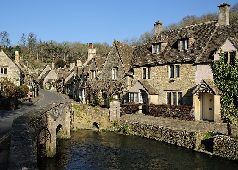
The Cotswolds is an area in south-central England, along a range of rolling hills that rise from the meadows of the upper Thames to an escarpment above the Severn Valley and Evesham Vale.
The area is defined by the bedrock of Jurassic limestone that creates a type of grassland habitat rare in the UK and that is quarried for the golden-coloured Cotswold stone. It contains unique features derived from the use of this stone; the predominantly rural landscape contains stone-built villages, historical towns and stately homes and gardens.
Designated as an Area of Outstanding Natural Beauty (AONB) in 1966, the Cotswolds covers 787 square miles (2,038 km2) and, after the Lake District and Yorkshire Dales national parks, is the third largest protected landscape in England and the largest AONB. Its boundaries are roughly 25 miles (40 km) across and 90 miles (140 km) long, stretching southwest from just south of Stratford-upon-Avon to just south of Bath near Radstock. It lies across the boundaries of several English counties; mainly Gloucestershire and Oxfordshire, and parts of Wiltshire, Somerset, Worcestershire, and Warwickshire. The highest point of the region is Cleeve Hill at 1,083 ft (330 m), just east of Cheltenham.
The hills give their name to the Cotswold local government district, formed on 1 April 1974, which is within the county of Gloucestershire. Its main town is Cirencester, where the Cotswold District Council offices are located. The population of the 450-square-mile (1,200 km2) District was about 83,000 in 2011. The much larger area referred to as the Cotswolds encompasses nearly 800 square miles (2,100 km2), over five counties: Gloucestershire, Oxfordshire, Warwickshire, Wiltshire, and Worcestershire. The population of the Area of Outstanding Natural Beauty was 139,000 in 2016.[1]
Church of St. John the Baptist
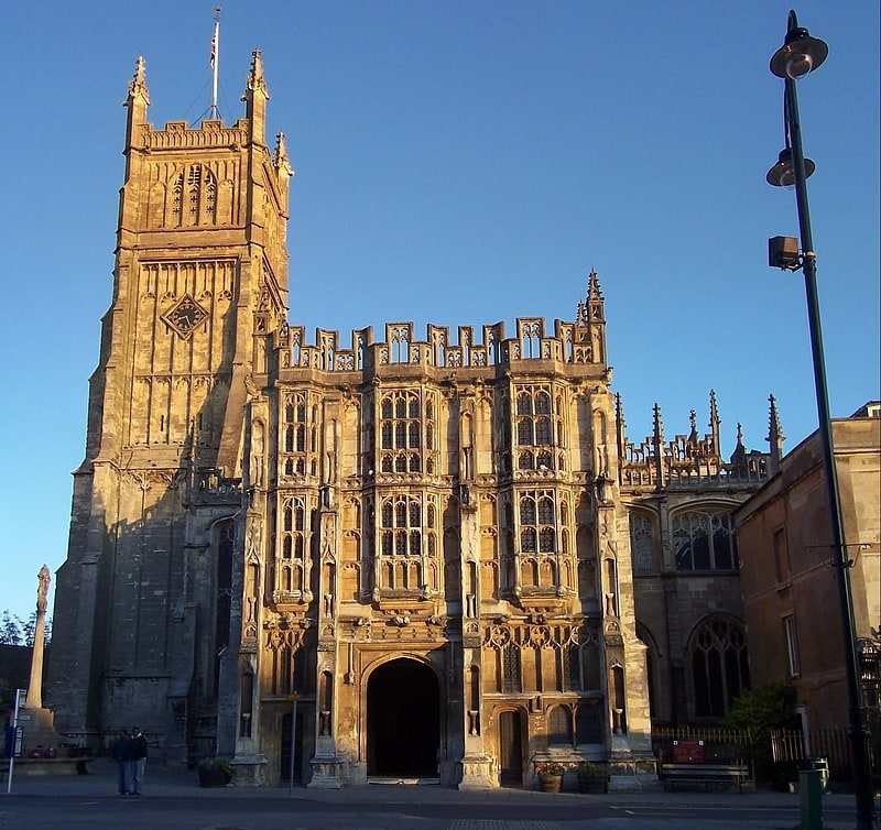
Episcopal church in Cirencester, England. The Church of St. John Baptist, Cirencester is a parish church in the Church of England in Cirencester, Gloucestershire, England. It is a Grade I listed building.
The building reflects architectural styles since the 12th century. The chancel and attached chapel represent the oldest part with the nave having been rebuilt twice and the tower added in the 15th century. The south porch was built by Cirencester Abbey around 1480 and only connected to the church in the 18th century.
It is built of Cotswold stone and is one of the "largest parish churches in England". It contains various tombs and monuments with some fragments of medieval stained glass and wall paintings.[2]
Address: Market Place, GL7 2NX Cirencester
Cirencester Amphitheatre
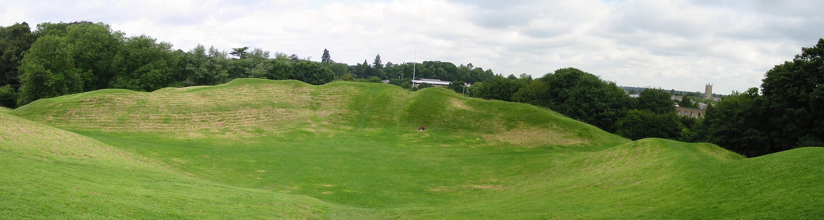
Tourist attraction in Cirencester, England. Cirencester Amphitheatre was a Roman amphitheatre in Cirencester, Gloucestershire, England. Its remains are scheduled as an ancient monument.
Archaeological digs have uncovered the earthworks, revealing the outline of the construction, which is still visible, with the banking reaching 25 feet from the bottom of the arena. The arena itself is approximately 150 feet (46 m) by 135 feet (41 m). Roman artefacts including coins and pottery have been discovered on the site. It is estimated that it was constructed towards the beginning of the 2nd century.
In Roman Britain, Cirencester was known as Corinium Dobunnorum, and was the second biggest town in Britannia, after Londinium (London). This amphitheatre is also the second largest, which indicates the significance of the location in Roman times. Although only slightly larger in diameter than the amphitheatre in Silchester, it has much higher sides. The earthworks show evidence of tiered wooden seats for around 8000 people, placed upon terraces made of stone, although a timber-only structure may have existed before the 2nd century. There are two entrances, at the north-east and south-west ends of the stadium.
During the 5th century, when the Western Roman Empire was under attack and soldiers returned to Rome to defend it, the amphitheatre was fortified to defend against the invading Saxons. Wooden structures were erected within the arena, placed in postholes, and the north-east entrance was partly blocked.
Unlike other amphitheatres, it is aligned in parallel to the streets of the town.
It has also been referred to as the 'Bull Ring', because the sport of bull-baiting used to take place there.
In 2012, plans were announced by the Cirencester Town Council to improve access and signage at the site. Further plans for a visitor centre and car park followed in 2014.[3]
Address: Cotswold Avenue, GL7 1XW Cirencester
Cirencester Park
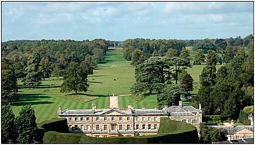
Building in England. Cirencester Park is a country house in the parish of Cirencester in Gloucestershire, England, and is the seat of the Bathurst family, Earls Bathurst. It is a Grade II* listed building. The gardens are Grade I listed on the Register of Historic Parks and Gardens.[4]
Address: Cecily Hill, Cirencester
St. Michael's Park
Park, Relax in park
Address: King Street, Cirencester