Discover 25 hidden attractions, cool sights, and unusual things to do in Cape Verde. Don't miss out on these must-see attractions: Pico do Fogo (Chã das Caldeiras), Dona Maria Pia Lighthouse (Praia) or Praça Alexandre Albuquerque (Praia).
Below, you can find the list of the most amazing places you should visit in Cape Verde.
Table of Contents
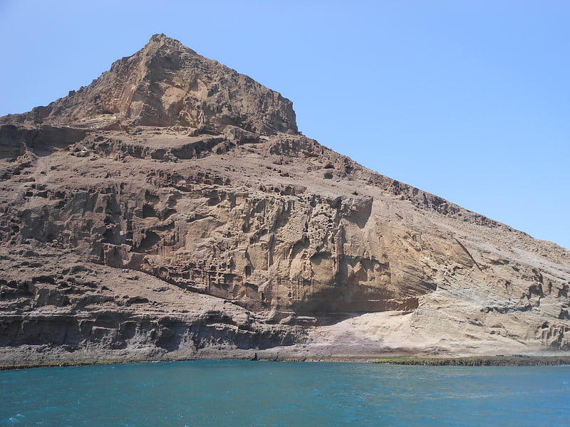
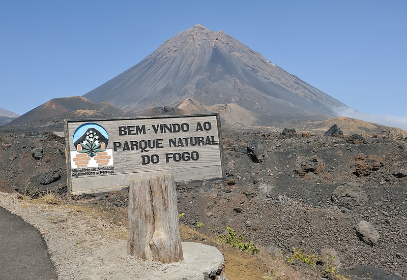
Pico do Fogo, Chã das Caldeiras
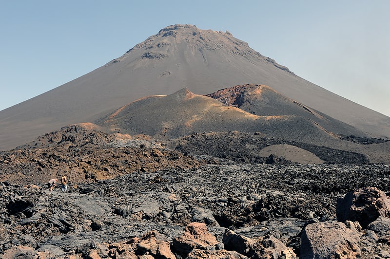
Peak in Cape Verde. Pico do Fogo pronounced is the highest peak of Cape Verde and West Africa, rising to 2,829 metres above sea level. It is an active stratovolcano lying on the island of Fogo. The main cone last erupted in 1680, causing mass emigration from the island. A subsidiary vent erupted in 1995. The only deadly eruption was in 1847 when earthquakes killed several people.
Fogo (the word means "fire" in Portuguese) is a hotspot volcanic island. Its most recent eruptions occurred in 1951, 1995 and 2014. It is the youngest and most active volcano in the Cape Verde Islands, a short chain of volcanic islands that generally are younger at the western end, formed as the African Plate moved towards the east over the hotspot.
Fogo consists of a single volcano, so the island is nearly round and about 25 kilometers (16 mi) in diameter. The large summit caldera (about 10 kilometers in the north–south direction and 7 kilometers in the east–west direction) is not located in the center of the island, but rather towards its northeastern corner. The caldera is bounded by steep near-vertical fault scarps on the north, west, and south sides but is breached to the east where lava can flow to the coast. North-northeast-trending eruptive fissures opened along the western flank of Pico, which formed inside the caldera between about 1500 and 1760. The last eruption from the top was in 1769. The current topography of Fogo, with the caldera open to the sea on the east side, results from the sliding of the east flank of the volcano towards the ocean.
The mountain's slopes are used to grow coffee, while its lava is used as building material. Near its peak is a caldera and a small village, Chã das Caldeiras, is inside this caldera. The crater rim, which reaches 2,700 m elevation, is known as Bordeira.[1]
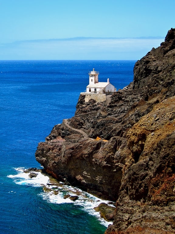
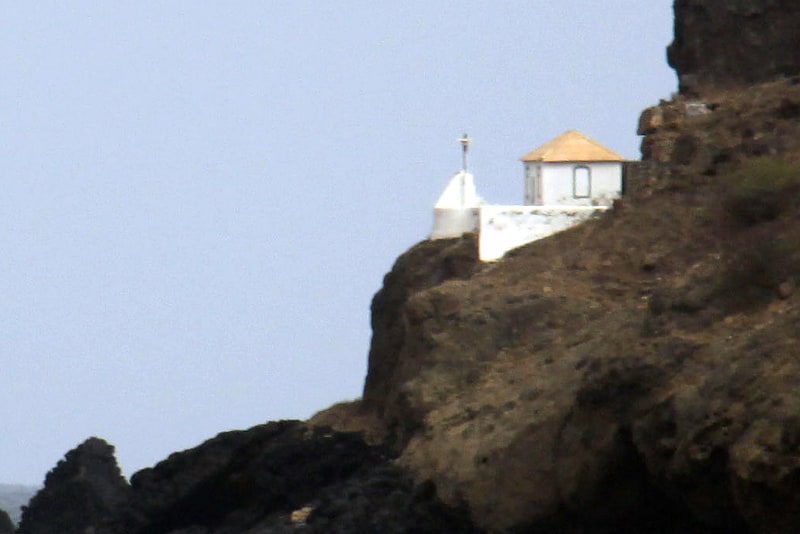
Dona Maria Pia Lighthouse, Praia
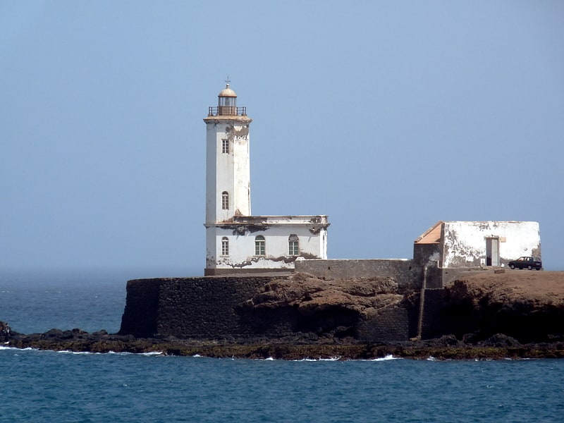
Also known as: Farol de D. Maria Pia
Historical landmark in Cape Verde. Farol de Dona Maria Pia is a lighthouse at the southernmost point of the island of Santiago, Cape Verde. It stands on the headland Ponta Temerosa, at the entrance of Praia Harbour, 2 km south of the city centre of Praia. The lighthouse was built in 1881 and was named after Maria Pia of Savoy, queen of Portugal at the time. The octagonal tower is 21 m high and its focal plane is 25 m above mean sea level. It is painted white. The lighthouse is used for navigational purposes.[2]
Praça Alexandre Albuquerque, Praia
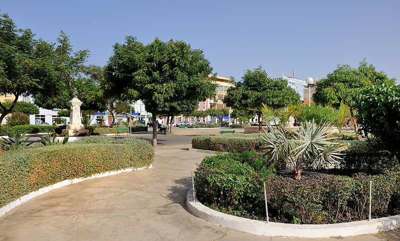
Tour agency in Praia, Cape Verde. Praça Alexandre Albuquerque is the main square of the capital city of Praia, Cape Verde. It is located in the southwestern part of the Plateau, the historical city centre of Praia. Formerly known as Praça do Pelourinho, it received its current name in 1876 in honour of the Portuguese colonial governor Caetano Alexandre de Almeida e Albuquerque. It is lined with several historical public buildings and townhouses, many of which date from the 19th century. The square is surrounded by Rua Patrice Lumumba, Rua Serpa Pinto and Avenida Amílcar Cabral.
The centre of the square is a public park with monuments to Alexandre Albuquerque (a bronze bust from 1926) and Serpa Pinto (a bronze bust from 1927). Notable buildings around the square:
- Pro-Cathedral of Our Lady of Grace, built between 1894 and 1902
- City hall (Câmara Municipal or Paços do Concelho) of Praia, built in 1858
- Palace of Culture "Ildo Lobo"
- Palace of Justice, built in 1961
- the banks Banco Comercial do Atlântico and Banco Interatlântico
Museu Etnográfico da Praia, Praia
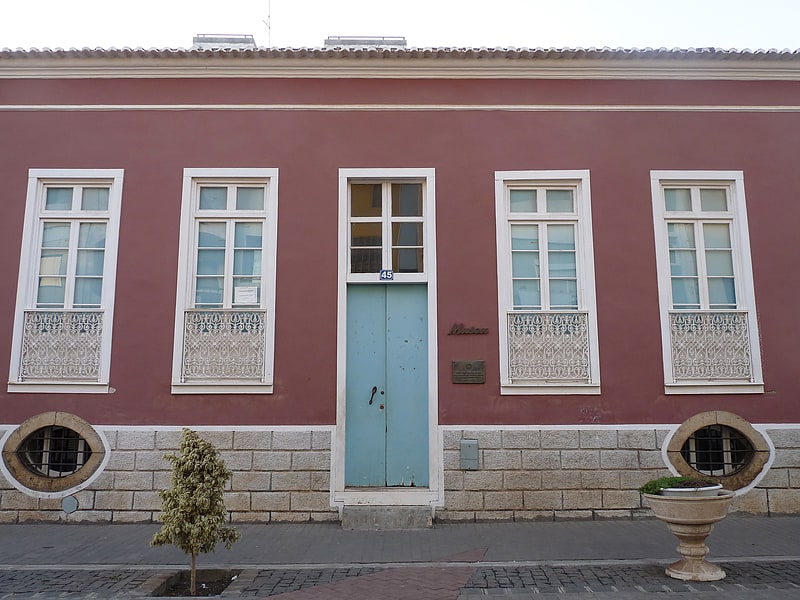
Museum in Praia, Cape Verde. Museu Etnográfico da Praia is an ethnographic museum in the Cape Verdean capital of Praia on the island of Santiago. It is located at 45 Rua 5 de Julho, in the historic part of the city, the Plateau. The museum was opened in November 1997 and is located in a 19th century building. The museum contains a selection of objects that represent the traditional uses and customs of the Cape Verdean people.[4]
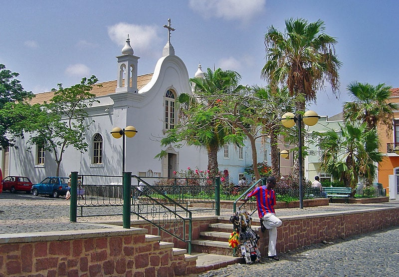
Nossa Senhora da Conceição church, Boa Vista
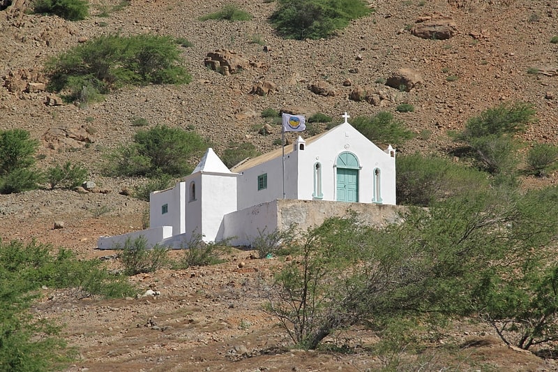
Also known as: Igreja de Nossa Senhora da Conceição
Nossa Senhora da Conceição church is a church at the southeastern edge of the village Povoação Velha, on the island of Boa Vista, Cape Verde. It sits at the foot of the mountain Rocha Estância.
It was built in 1828. Its interior is decorated with a colourfully painted chancel that has numerous little images of saints. Each year on December 8, the Feast of the Immaculate Conception is celebrated and forms one of the major religious celebrations on the island.[5]
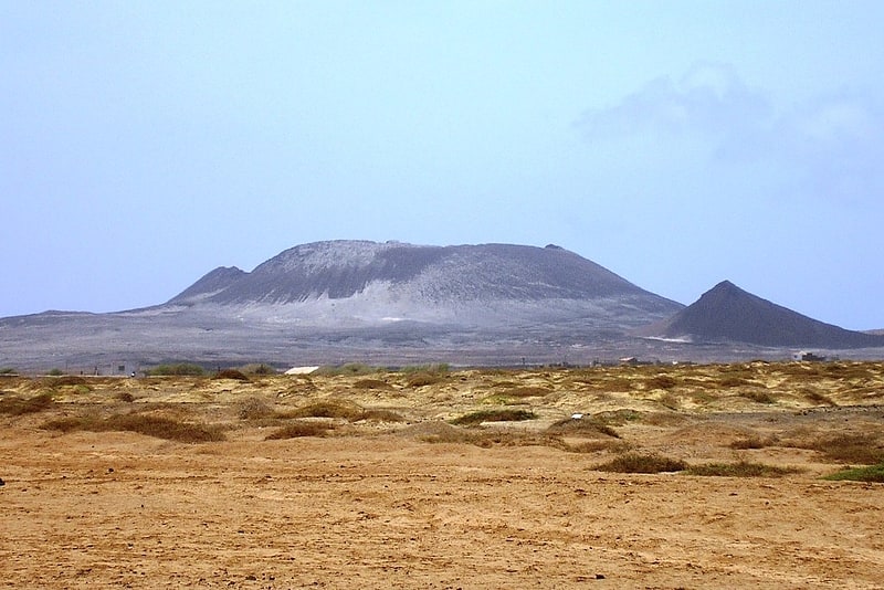
Monte Curral, Sal
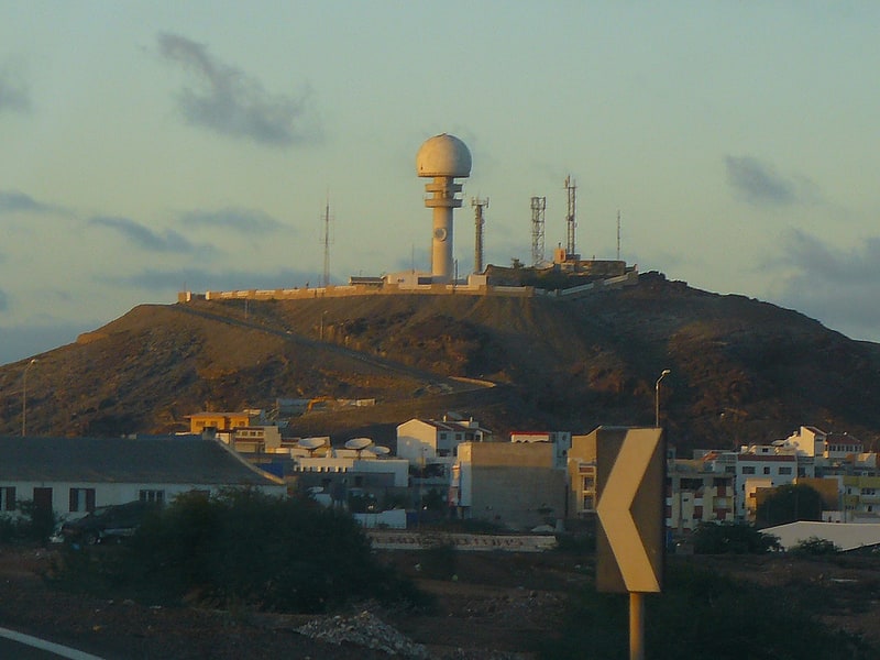
Hill in Cape Verde. Monte Curral is a hill in the city of Espargos, on the island of Sal, Cape Verde. Its elevation is 109 meters. On the summit there is an air control tower for the nearby Amílcar Cabral International Airport, as well as several telecommunication masts.[6]
Address: Strasse neben Igreja Catolica hinauf, Sal
Baía da Parda, Sal
Baía da Parda is a small bay on the east coast of the island of Sal, Cape Verde. It lies about 3 km south of Pedra de Lume, and 5 km southeast of the island capital Espargos. It is known for its reefs, which are frequented by sharks.[7]
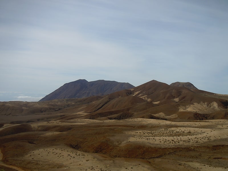
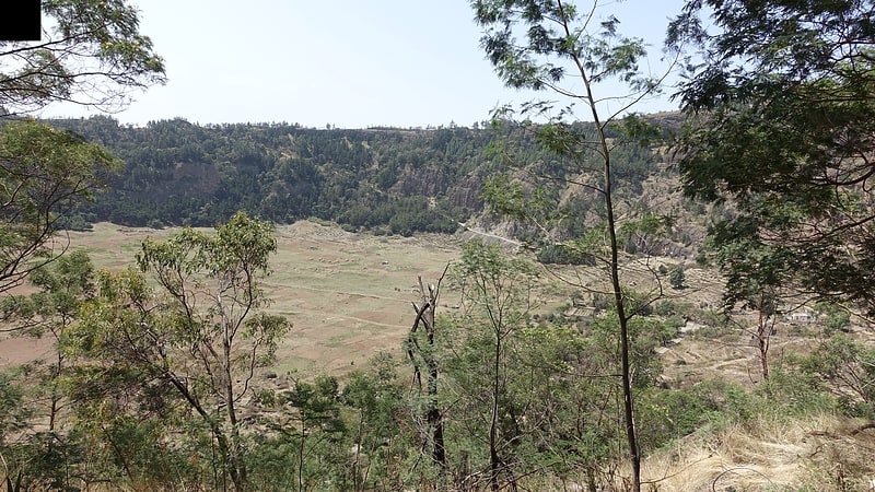
Bordeira, Chã das Caldeiras
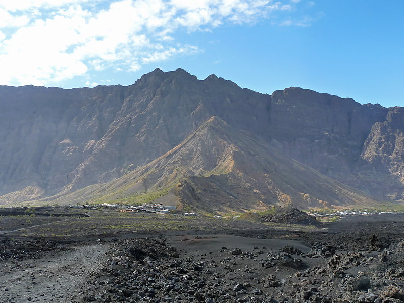
Mountain. Bordeira is a semicircular mountain in the middle of the island Fogo. It is a crater rim, up to 1 km high, formed by a prehistoric collapse of the volcano Pico do Fogo. At a maximum elevation of 2,692 metres, it is the second highest point in the nation behind Pico do Fogo. The name literally means the "border". It forms part of Fogo Natural Park. Opening to the east, it effectively protects the northern, western and southern part of the island against lava flows from the volcano. The settlement Chã das Caldeiras lies at the foot of Bordeira, in the caldera. The east side of the Bordeira cliff is much steeper than the west side.[8]
Rabo de Junco, Sal
Rabo de Junco is a hill on the west coast of the island of Sal in Cape Verde. It is situated at the northern end of the Baía da Murdeira, 8 kilometres southwest of the island capital Espargos. Its steep eroded south face towards the bay is an important nesting area for birds. Rabo de Junco and the surrounding 154 hectares are protected as a nature reserve. It was mentioned as Rabadyunk in the 1747 map by Jacques-Nicolas Bellin. To its west lies the uninhabited islet Ilhéu Rabo de Junco.[9]
Praça Amílcar Cabral, Mindelo
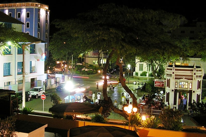
Praça Amílcar Cabral, also popularly known as Praça Nova, is an important square of the city of Mindelo, São Vicente, Cape Verde. It is located in the northern part of the city center of Mindelo. The square is named after Amílcar Cabral, a leader of the independence movement of Cape Verde and Guinea-Bissau. Constructed in 1895, it was named after the colonial administrator Serpa Pinto until Cape Verdean independence in 1975. It was laid out in a new, previously undeveloped part of the town. The square is surrounded by Rua Angola to the north, Rua Argelia to the east, Rua Patrice Lumumba to the south and Rua 5 de Julho to the west.
Notable buildings and structures around the square:
- Centro Nacional de Artesanato e Design (end of the 19th century)
- Cinema Éden Park (1922)
- the kiosk (1932)
- the New Building (1907-1910), built for the British company that operated the transatlantic telegraph cable, currently houses the telephone company CV Telecom
Topo da Coroa, Santo Antão
Mountain in Cape Verde. Tope de Coroa is a mountain on the island of Santo Antão's, Cape Verde. At 1,979 m elevation, it is the highest point of the island. It is in the western part of the island, 25 km west of the island capital Porto Novo. The mountain is entirely of volcanic origin. The area is the source of several streams including Ribeira de Monte Trigo which flows westward to Monte Trigo.
The mountain forms part of a natural park, covering 84.92 km2 (32.79 sq mi). It contains 61% of the endemic angiosperm plants of Cape Verde, of which 25% are in the red list of endangered species, including Periploca laevigata subsp. chevalieri. Free grazing is a threat to the biodiversity of the area. Tope de Coroa consists of relatively young volcanic rock, formed between 200,000 and 170,000 years ago.[11]
Pro-Cathedral of Our Lady of the Light, Mindelo
Building. The Pro-Cathedral of Our Lady of the Light is a Roman Catholic church in the city of Mindelo, on the island of São Vicente, Cape Verde. It is located on Rua da Luz, in the city centre. Built in 1862, it is one of the oldest buildings of Mindelo. However, the church has been enlarged recently, leaving only the façade in its original state. It is the seat of the Roman Catholic Diocese of Mindelo, created in 2003.[12]
Cova, Santo Antão
Caldera. Cova is a volcanic caldera in the eastcentral part of the island of Santo Antão in Cape Verde. It is situated at the southwestern end of the municipality of Paul. Its lowest point is 1,166 meters, and the highest point of the crater rim is about 1,500 m. The diameter of the caldera is about 1.0 km. It forms a part of Cova-Paul-Ribeira da Torre Natural Park. The Cova formation dates from between 1.4 million and 700,000 years ago.
The Cova crater benefits from high precipitation values carried by trade winds. At the bottom of the caldera maize and beans are grown. Natural and semi-natural vegetation occupies the crater walls facing north and northeast. South facing walls are covered with a forest of Pinus and Cupressus species. There is a small village in the crater (population 10 at the 2010 census), part of the settlement Cabo da Ribeira.[13]
Morro de Areia Nature Reserve, Boa Vista
Nature preserve in Cape Verde. Morro de Areia Nature Reserve is a nature reserve covering the southwestern coast of the island of Boa Vista in Cape Verde. It takes its name from the hill Morro de Areia, 167 m elevation. The natural reserve covers 21.31 km2 of land area, and stretches along the coast from the Praia de Chaves in the north to the Praia de Santa Monica in the south. The reserve includes a 300 m wide marine protection zone, an additional 4.36 km2.[14]
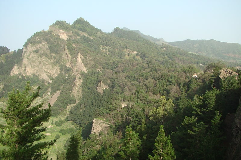
Serra da Malagueta, Santiago
Mountain range in Cape Verde. Serra Malagueta is a mountain range located in the northern part of the island of Santiago, Cape Verde. At 1064 m elevation, it is highest point of northern Santiago. The mountain range is protected as the Serra Malagueta Natural Park, that was established on February 24, 2005 and covers 774 hectares. The natural park is situated in the municipalities Tarrafal, São Miguel and Santa Catarina. The summit is in São Miguel, south of the Ribeira Principal valley. The Serra Malagueta formation is of volcanic origin, and was formed between 2.9 and 2.4 million years ago.[15]
Viana, São Vicente
Volcano in Cape Verde. Viana is a low volcano in the southeastern part of the island of São Vicente, Cape Verde. Its elevation is 163 metres. It is situated 3 kilometres south of Calhau and 14 kilometres southeast of the island capital Mindelo.[16]
Dona Amélia Lighthouse, São Vicente
Also known as: Farol de D. Amélia
Lighthouse. Farol de D. Amélia is a lighthouse in the southwestern point of the island of São Vicente in northwestern Cape Verde. It lies 3 km west of the village of São Pedro. The lighthouse is a white square tower with a lantern and a gallery, 14 m high. The lighthouse was completed in 1894.[17]
Jardim Botanico, Santiago
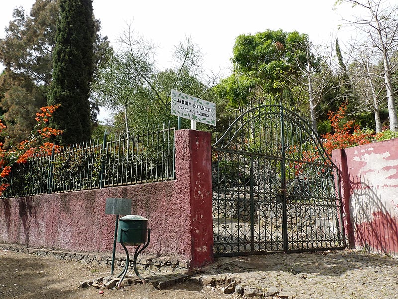
Hotel in São Jorge dos Órgãos, Cape Verde. The Jardim Botânico Nacional Grandvaux Barbosa is the only botanical garden in Cape Verde. The garden is located in São Jorge, in the middle of the island Santiago. Its collection focuses on endemic and native plants of Cape Verde.
The garden was created in 1986 and was named after the Franco-Portuguese botanist Luís Augusto Grandvaux Barbosa (1914-1983). It is located 400 m above sea level and covers 20,000 m2. It is part of the School of Agricultural and Environmental Sciences (the former "INIDA", National Institute of Agrarian Studies and Development), part of the University of Cape Verde.
Endemic and native plants in the garden include Phoenix atlantica, Euphorbia tuckeyana, Echium hypertropicum, Echium stenosiphon, Artemisia gorgonum, Micromeria forbesii, Aeonium gorgoneum and Campanula jacobaea.[18]
Praia de Santa Mónica, Boa Vista
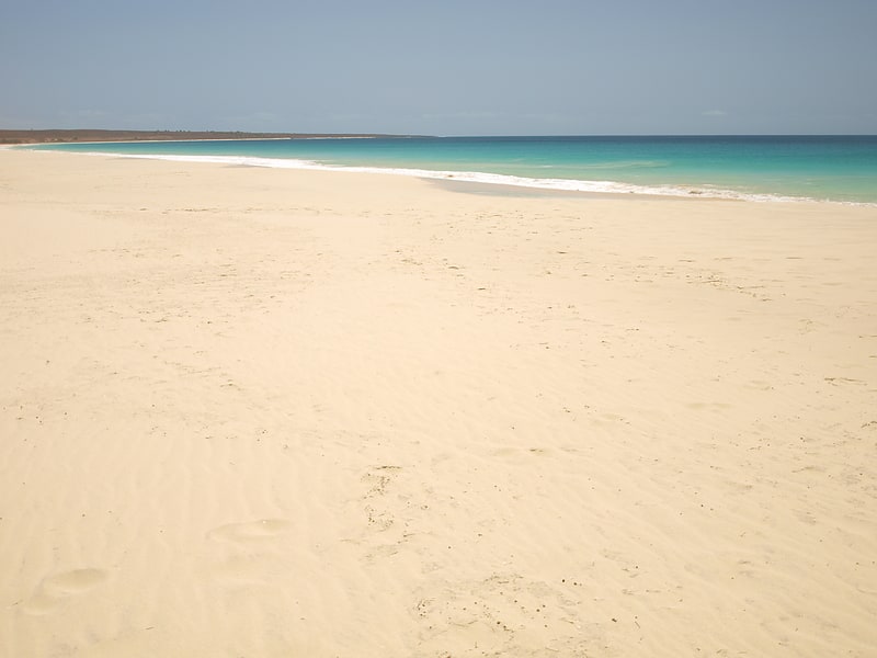
Praia de Santa Mónica is a sandy beach in the southwestern part of the island of Boa Vista in Cape Verde. The nearest village is Povoação Velha, 5 km to the north. The beach is adjacent to the protected area Morro de Areia Nature Reserve, which is important for endemic birds and turtles. Praia de Santa Mónica is part of a tourism development zone.[19]
Monte Cara, São Vicente
Mountain in Cape Verde. Monte Cara is a mountain in western part of the island of São Vicente, Cape Verde. Its elevation is 490 m. It resembles a human face looking at the sky, hence its name, which means "face mountain". It is a landmark of the city of Mindelo, from which it can be seen across Porto Grande Bay.
The album Voz d'Amor (2003) by Cesária Évora contains the song Monte Cara.[20]
Ponta Preta Lighthouse, Santiago
Also known as: Farol da Ponta Preta
Farol da Ponta Preta is a lighthouse in the northwesternmost part of the island of Santiago, Cape Verde. It stands on the headland Ponta Preta, 3 km northwest of the city Tarrafal. The lighthouse was constructed in 1889. Its lantern stands on a white column with a pyramidal base, in front of a small one storey building. The lighthouse was depicted on a Cape Verdean stamp in 2004.[21]
Pico da Cruz, Santo Antão
Mountain in Cape Verde. Pico da Cruz is a mountain in the eastern part of the island of Santo Antão. Its elevation is 1585 m. It is 5 km southwest of the town Pombas. It gives its name to the nearby village of Pico da Cruz, part of the municipality of Paul. Pico da Cruz is part of the protected area Cova-Paul-Ribeira da Torre Natural Park.[22]
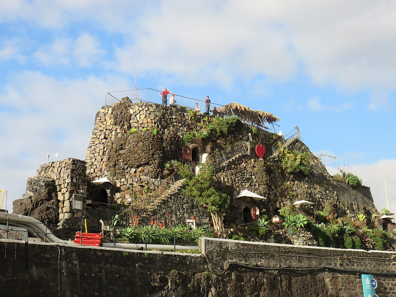
Fortim d'El-Rei, Mindelo
Fortim d'El Rei is a fort in Mindelo, in the island of São Vicente, Cape Verde. It is located on a hill north of the city centre, in the neighbourhood Fortinho. It was built in 1852 for the defence of Porto Grande Bay and the city of Mindelo. Since 1930, it was only used for civil purposes, and it gradually fell into disrepair.[23]
Fogo Volcanic Important Bird Area, Chã das Caldeiras
National park in Cape Verde. Fogo Natural Park, on the island of Fogo, is one of ten "natural parks" in the country of Cape Verde. The protected area is 84.69 km2, which is 17.8% of the total area of the island. 50% of the park lies within the municipality Santa Catarina do Fogo, 28% in municipality of Mosteiros and 22% in São Filipe. The natural park is situated in the interior of the island, and covers the volcano Pico do Fogo, its crater and crater rim and the forest of Monte Velha. The volcano is active; the most recent eruption was in 2014-15.[24]
Forte de São José, Maio
Fortress in Vila do Maio, Cape Verde. Forte de São José is a fort located in the city of Porto Inglês in the southern part of Maio Island, Cape Verde. It was built by the Portuguese around 1743, in order to protect the town of Porto Inglês from pirate attacks. Today, the fort is one of the tourist attractions of the town.[25]