Discover 11 hidden attractions, cool sights, and unusual things to do in Santo Antão (Cape Verde). Don't miss out on these must-see attractions: Topo da Coroa, Cova, and Pico da Cruz. Also, be sure to include Fontes Pereira de Melo Lighthouse in your itinerary.
Below, you can find the list of the most amazing places you should visit in Santo Antão (Porto Novo).
Table of Contents
Topo da Coroa
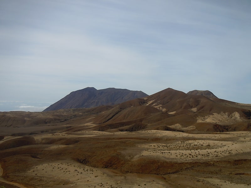
Mountain in Cape Verde. Tope de Coroa is a mountain on the island of Santo Antão's, Cape Verde. At 1,979 m elevation, it is the highest point of the island. It is in the western part of the island, 25 km west of the island capital Porto Novo. The mountain is entirely of volcanic origin. The area is the source of several streams including Ribeira de Monte Trigo which flows westward to Monte Trigo.
The mountain forms part of a natural park, covering 84.92 km2 (32.79 sq mi). It contains 61% of the endemic angiosperm plants of Cape Verde, of which 25% are in the red list of endangered species, including Periploca laevigata subsp. chevalieri. Free grazing is a threat to the biodiversity of the area. Tope de Coroa consists of relatively young volcanic rock, formed between 200,000 and 170,000 years ago.[1]
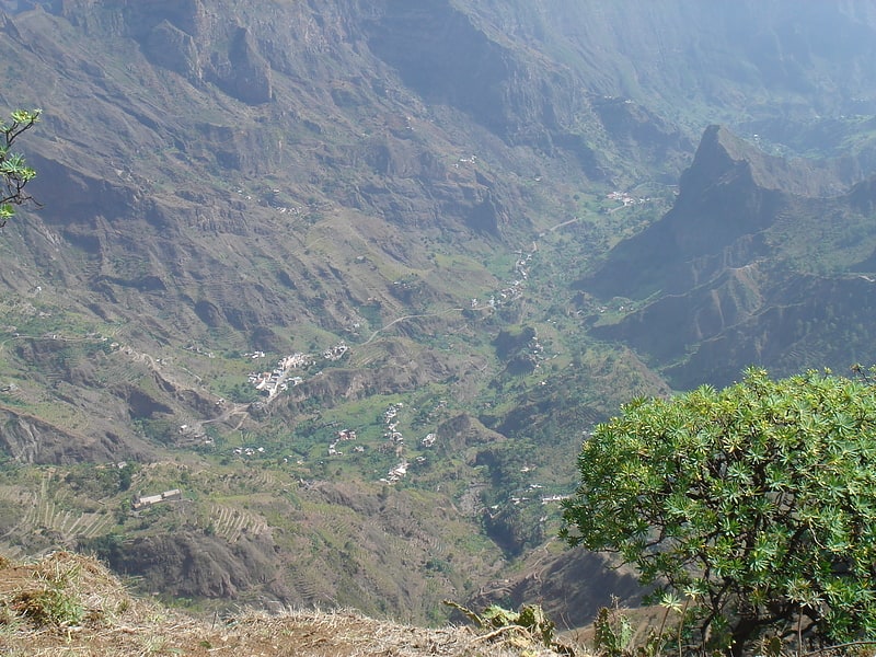
Cova
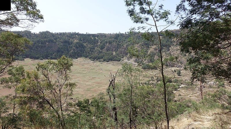
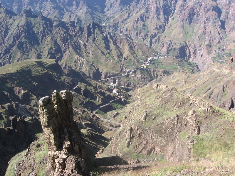
Caldera. Cova is a volcanic caldera in the eastcentral part of the island of Santo Antão in Cape Verde. It is situated at the southwestern end of the municipality of Paul. Its lowest point is 1,166 meters, and the highest point of the crater rim is about 1,500 m. The diameter of the caldera is about 1.0 km. It forms a part of Cova-Paul-Ribeira da Torre Natural Park. The Cova formation dates from between 1.4 million and 700,000 years ago.
The Cova crater benefits from high precipitation values carried by trade winds. At the bottom of the caldera maize and beans are grown. Natural and semi-natural vegetation occupies the crater walls facing north and northeast. South facing walls are covered with a forest of Pinus and Cupressus species. There is a small village in the crater (population 10 at the 2010 census), part of the settlement Cabo da Ribeira.[2]
Pico da Cruz
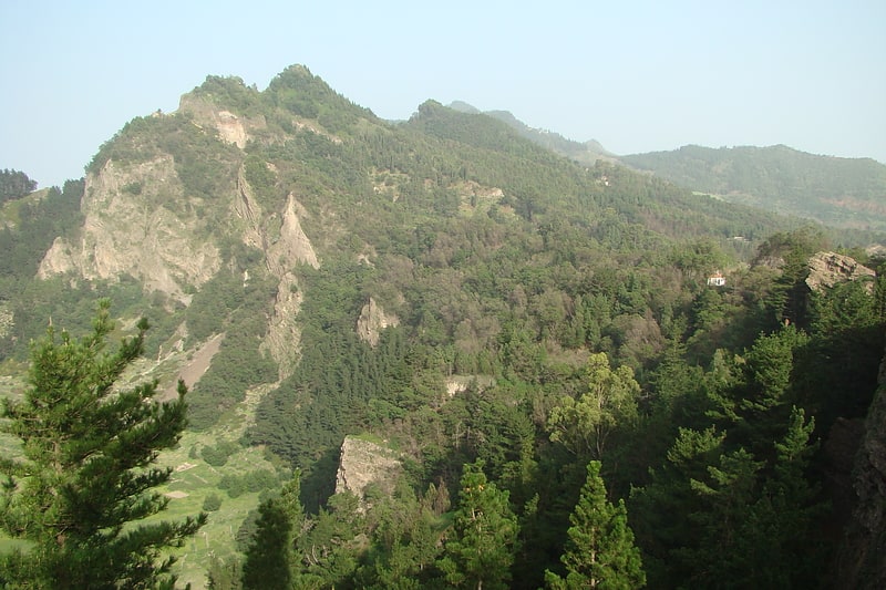
Mountain in Cape Verde. Pico da Cruz is a mountain in the eastern part of the island of Santo Antão. Its elevation is 1585 m. It is 5 km southwest of the town Pombas. It gives its name to the nearby village of Pico da Cruz, part of the municipality of Paul. Pico da Cruz is part of the protected area Cova-Paul-Ribeira da Torre Natural Park.[3]
Fontes Pereira de Melo Lighthouse
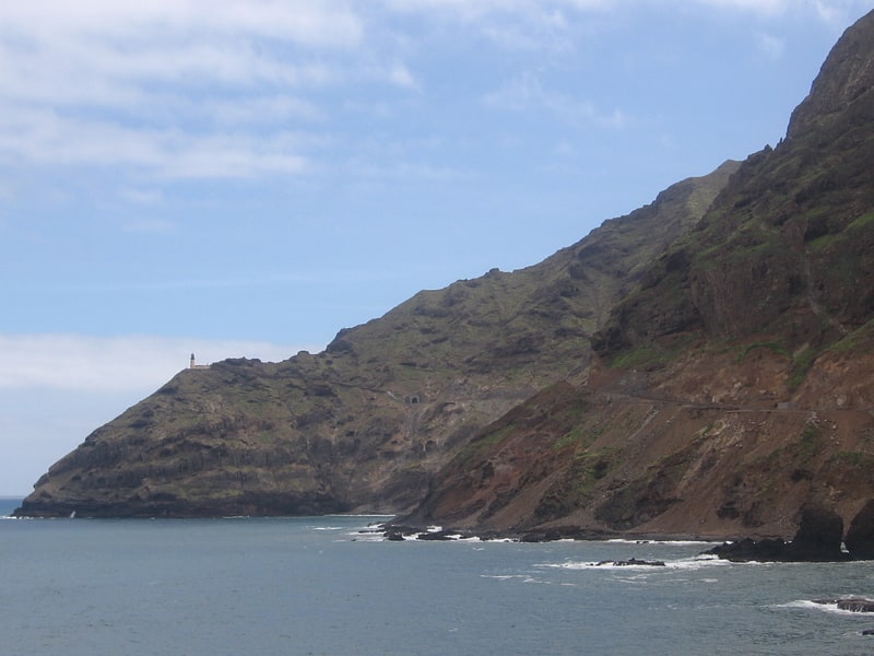
Also known as: Farol de Fontes Pereira de Melo
Lighthouse in Cape Verde. Farol de Fontes Pereira de Melo is a lighthouse at the northeastern point of the island of Santo Antão in northwestern Cape Verde. It is situated on the headland Ponta de Tumbo, 2 km east of Janela, 6 km southeast of Pombas and 15 km northeast of Porto Novo. The lighthouse was named after Fontes Pereira de Melo, prime minister of Portugal for several times between 1871 and 1886. It is a white octagonal masonry tower, 16 meters high. Its focal height is 162 meters above sea level, and its range is 17 nautical miles. The adjacent building for the lighthouse keeper is abandoned and in poor condition.[4]
Tarrafal de Monte Trigo
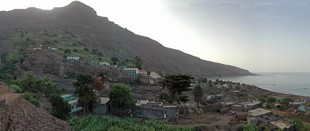
Human settlement in Santo Antão, Cape Verde. Tarrafal de Monte Trigo is a settlement in the southwestern part of the island of Santo Antão, Cape Verde. In 2010 its population was 841. It is situated on the coast, 27 km west of the island capital Porto Novo. The settlement was mentioned as Terrafal in the 1747 map by Jacques-Nicolas Bellin.[5]
Fontainhas
Village in Santo Antão, Cape Verde. Fontainhas is a settlement in the northern part of the island of Santo Antão, Cape Verde. It is situated near the rocky north coast of the island, 2 km southwest of Ponta do Sol and 19 km north of the island capital Porto Novo. The settlement includes the smaller villages Corvo and Forminguinhas, about 1 km west of Fontainhas proper.[6]
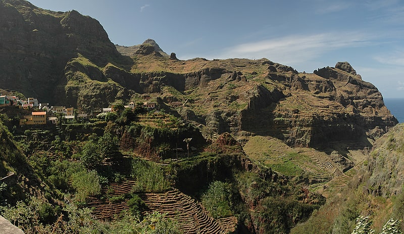
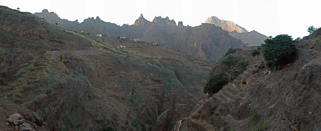
Corda
Municipality in Santo Antão, Cape Verde. Corda is a settlement in the island of Santo Antão, Cape Verde. It is part of the municipality Ribeira Grande. It is situated in the mountainous interior of the island at about 1,000 meters elevation, 13 km north of the island capital Porto Novo. Corda consists of several villages, including Chã de Corda and Esponjeiro. The national road from Porto Novo to Ribeira Grande passes through Corda. The crater of Cova lies 4 km to the southeast. Corda lies in the Cova-Paul-Ribeira da Torre Natural Park.
Two species of cuckoo bees, Thyreus batelkai and Chiasmognathus batelkai, have been found near Esponjeiro. Also a subspecies of butterflies, Leptotes pirithous capvertis has been found near Esponjeiro.[7]
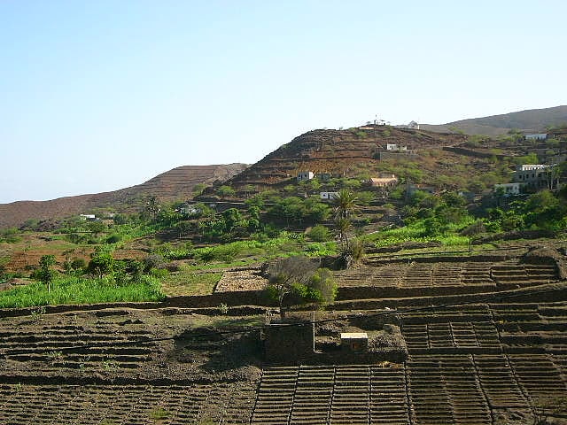
Cabo da Ribeira
Municipality. Cabo da Ribeira is a settlement in the eastern part of the island of Santo Antão, Cape Verde. In 2010 its population was 912. It is situated at about 500 m elevation in the upper valley of the Ribeira do Paul, 5 km southwest of Pombas. It is part of the municipality of Paul, and lies in the Cova-Paul-Ribeira da Torre Natural Park.[8]
Ribeira da Cruz
Municipality in Santo Antão, Cape Verde. Ribeira da Cruz is a settlement in the northwestern part of the island of Santo Antão, Cape Verde. Situated 22 km northwest of the island capital Porto Novo, it is part of the parish of Santo André, in the municipality of Porto Novo. It had 421 inhabitants at the 2010 census.[9]
Garça de Cima
Garça de Cima is a settlement in the northern part of the island of Santo Antão, Cape Verde. It is situated in the upper valley of the river Ribeira da Garça, 15 km northwest of the island capital Porto Novo. The southernmost part lies in Moroços Natural Park.[10]
Alto Mira
Locality in Santo Antão, Cape Verde. Alto Mira is a settlement in the northwestern part of the island of Santo Antão, Cape Verde. It is situated 4 km southeast of Ribeira da Cruz and 18 km northwest of the island capital Porto Novo. Its population was 1,003 at the 2010 census. The Moroços Natural Park lies east of the settlement. The settlement is divided into several localities, including Chã Bonita, Chã Daurinca, Chã de Dragoeiro, Dominguinhas, Faial and Lombo Gorado. The Ribeira Alto Mira flows through the settlement.[11]