Discover 9 hidden attractions, cool sights, and unusual things to do in Kronotsky Nature Reserve (Russia). Don't miss out on these must-see attractions: Uzon, Kizimen, and Valley of Geysers. Also, be sure to include Kikhpinych in your itinerary.
Below, you can find the list of the most amazing places you should visit in Kronotsky Nature Reserve (Kamchatka).
Table of Contents
Uzon
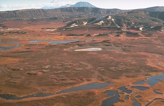
Also known as: Узон
Scenic caldera with geothermal activity. Uzon is a 9 by 12 km volcanic caldera located in the eastern part of Kamchatka Peninsula, Russia. Together with the Geyzernaya caldera it hosts the largest geothermal field in the Kamchatka Peninsula. The calderas were formed in the mid-Pleistocene in several large eruptions that deposited 20–25 km3 of ignimbrite over a wide area. Lake Dalny fills a Holocene maar in the northeast of Uzon Caldera.
The Uzon Caldera is a location of the occurrence of extremophile micro-organisms due to its high localized temperatures.(C.Michael Hogan. 2010)[1]
Kizimen
Also known as: Кизимен
Stratovolcano in Russia. Kizimen is an active stratovolcano in the southern part of Kamchatka Peninsula, Russia.
The volcano was in a dormant state since an eruption in 1929, but on 2 September 2009 it was reported by Georgina Cooper for the Reuters news agency that the crater lake temperature had risen 10 degrees Celsius in a week and plumes of steam were rising from its flanks. The activity continued throughout 2010, with the formation of new fumaroles reported in November. Seismic activity and ash emission continued to build over the following weeks, and in January 2011 a hotspot was recorded, indicating the presence of lava. In early February 2011 the volcano sent a column of ash several kilometres high.
In April 2011, it was reported that the volcanic activity and ash were threatening the endangered wild reindeer of the area.
On 31 December 2012, following a 24-hour period of some 357 earthquakes reported under the volcano, Kizimen was raised to 'orange alert' status. An eruption was reported on 10 January 2013, with the ash plume reaching 4,200 m (13,800 ft) altitude.
On December 7, 2013 activity at Kizimen and nearby Kliuchevskoi significantly increased, continued during November 29 - December 7, prompting KVERT to raise the Alert Level to Red. Ash plumes rose to altitudes of 5.5–6 km (18,000-19,700 ft) a.s.l. and drifted more than 212 km NE and over 1,000 km E. According to a news article, a warning to aircraft was issued for the area around the volcanoes. Video showed gas-and-steam activity, and satellite images detected a daily weak thermal anomaly. On December 9, the Alert Level was lowered to Green when the eruptions stopped.
The volcano is not well understood, and research has indicated that the volcano could erupt in a similar fashion to the famous 1980 eruption of Mount St Helens.[2]
Valley of Geysers
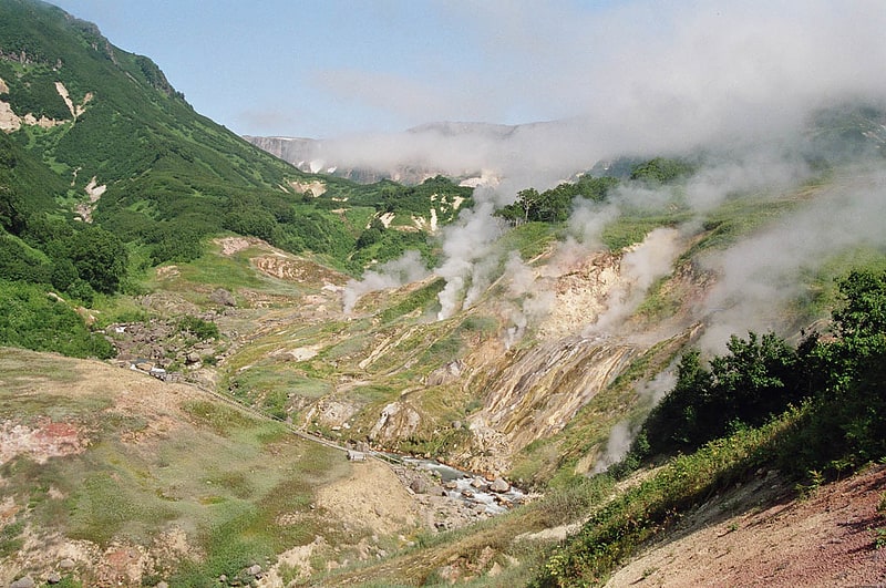
Also known as: Долина гейзеров
The Valley of Geysers is a geyser field on Kamchatka Peninsula, Russia, and has the second largest concentration of geysers in the world. This six-kilometre-long basin with approximately ninety geysers and many hot springs is situated on the Kamchatka Peninsula in the Russian Far East, predominantly on the left bank of the ever-deepening Geysernaya River, into which geothermal waters flow from a relatively young stratovolcano, Kikhpinych. Temperatures have been found to be 250 °C, 500 m below the caldera ground. It is part of the Kronotsky Nature Reserve, which, in turn, is incorporated into the World Heritage Site "Volcanoes of Kamchatka". The valley is difficult to reach, with helicopters providing the only feasible means of transport.[3]
Address: Kronotskiy State Natural Biosphere Reserve, Kronotsky Nature Reserve
Kikhpinych
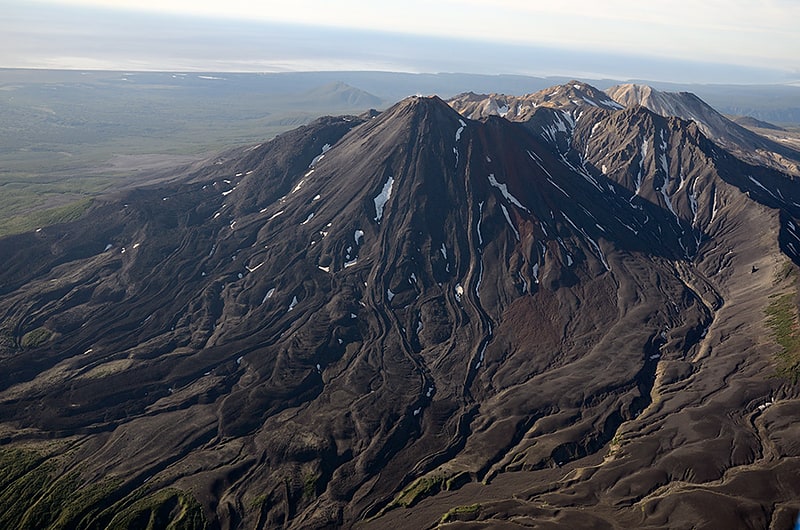
Also known as: Кихпиныч
Stratovolcano in Russia. Kikhpinych is a stratovolcano located in the eastern part of the Kamchatka Peninsula, which feeds the famous Valley of Geysers.
At its foot is a 2 by 0.5 kilometres (1.24 by 0.31 mi) area known as the "Valley of Death", where volcanic gases accumulate and kill birds and mammals that enter the valley. Research in the 1970s and 1980s showed that a mix of hydrogen sulphide, carbon dioxide, sulphur dioxide and carbon disulphide was produced by the volcano, gathering in a valley area where it could not be easily dispersed by winds and creating a predator trap. The gas forms in spring when the snow melts, first killing birds which drink at the river, followed by foxes and other carnivores which are attracted to the carrion.[4]
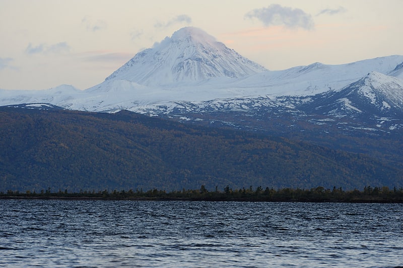
Kronotsky
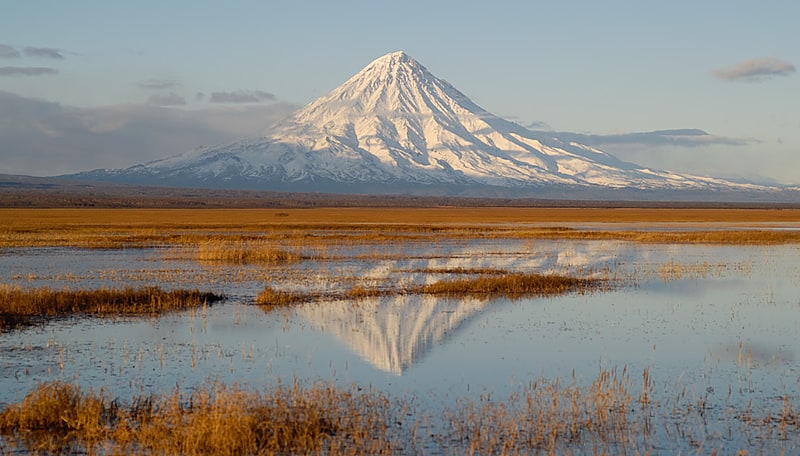
Also known as: Кроноцкая Сопка
Scenic volcano in a nature reserve. Kronotsky is a major stratovolcano on the Kamchatka Peninsula, Russia. It is located in Kronotsky Nature Reserve to the east of Lake Kronotskoye. It has a particularly symmetrical conical shape, comparable to Mount Fuji in Japan and to Mayon Volcano in the Philippines. The summit crater is plugged by a volcanic neck, and the summit itself is ice-capped. It exhibits the classic radial drainage pattern, extending downward from its crater. Kronotsky is considered to be one of the most scenic volcanoes in Kamchatka. In the 20th century, the volcano had low activity, with occasional weak phreatic eruptions.[5]
Lake Kronotskoye
Also known as: Кроноцкое
Lake in Russia. Lake Kronotskoye is a triangle-shaped lake located in Kamchatka Krai, Russia, 30 kilometres north of the Valley of Geysers and 40 kilometres away from the east coast of the Kamchatka Peninsula. It is named after the nearby volcano Kronotsky, part of the Eastern Range, whose name presumably derives from Itelmen krának, "high stone mountain." It was formed about 10,000 years ago when lava and pyroclastic flows from eruptions of the Kronotsky and Krasheninnikov volcanoes dammed the Kronotskaya River.
Lake Kronotskoye covers an area of 246 square kilometres (95 sq mi) and has an average depth of 58 metres (190 ft) and a volume of 14.2 cubic kilometres (3.4 cu mi). The lake drains an area of 2,330 square kilometres (900 sq mi), with the Listvennichnaya, Unana and Uzon being the largest rivers to flow into it. The lake drains into Kronotskaya River in its southeast corner, which flows 39 kilometres (24 mi) southeast into the Pacific Ocean.
Lake Kronotskoye freezes over from late December to mid-May to a depth of one metre. It is a dimictic lake, reaching isothermy in July and late November. The water is cold even in summer, not exceeding 16 °C (61 °F) even at its warmest in September. The pH at the surface decreases from 8.7 to 8.0 during the growing season.
Massive rapids at the head of the Kronotskaya River prevent fish from entering or leaving the lake. Those that live in the lake are therefore of special scientific interest as model studies in microevolution processes. They comprise a population of landlocked sockeye or kokanee salmon and a group of char distinguished by its significant polymorphism and plasticity: researchers have identified between three and five different forms. There are 11 islands in the eastern side of the lake which cover a total area of around 0.5 square kilometres (0.19 sq mi) and host a colony of about 600 pairs of slaty-backed gulls. Lake Kronotskoye is also well known for its population of swans.
The area surrounding the lake is uninhabited and protected as Kronotsky Nature Reserve, a component of the Volcanoes of Kamchatka World Heritage Site. The first Russians to reach the lake were the members of F.P. Ryabushinsky's Kamchatka expedition of 1908; the islands in the lake are named after them.[6]
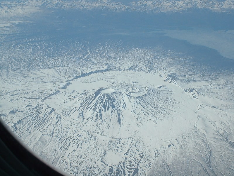
Krasheninnikov Volcano
Also known as: Вулкан Крашенинникова
Stratovolcano in Russia. Krasheninnikov is a complex of two overlapping stratovolcanoes inside a large caldera on the eastern coast of Kamchatka Peninsula, Russia. It is located in Kronotsky Nature Reserve to the south of Lake Kronotskoye, and is named after explorer Stepan Krasheninnikov.
The tephra from the caldera's forming eruption lies on top of material from an eruption that occurred 39,000 years ago. It is believed that the two layers are related. The southern of the two cones was constructed over a 4,500 year period beginning 11,000 years ago. The northern cone formed in the same amount of time, but started forming after the southern cone was complete.
The current eruption cycle began approximately 600 years ago. The most recent eruption was around 1550 AD.[7]
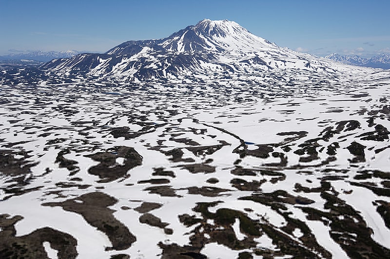
Taunshits
Also known as: Тауншиц
Stratovolcano in Russia. Taunshits is a stratovolcano located in the eastern part of the Kamchatka Peninsula, Russia.
It is part of the Kamchatka-Kurile volcanic arc, and volcanism in this arc is caused by the subduction of the Pacific Plate beneath the Okhotsk Plate. More specifically, volcanic activity at Taunshits relates to a local system of eastward-trending faults, and some additional volcanoes are controlled by the same fault system, such as Uzon and Kikhpinych which lie both east of Taunshits.
Taunshits is a somma volcano and features lava flows, and its summit is formed by a ridge. The stratovolcano contains a collapse crater formed during the Holocene, as well as a lava dome; a viscous lava flow was erupted in the crater and extends down the western flank. Erosion has formed gullies in the slopes of the volcano. Two satellite vents and several cinder cones are found south of the edifice.
Taunshits has principally erupted andesite and basaltic andesite, and its eruption products are calc-alkaline with moderate potassium content. Volcanic activity at Taunshits involves the formation of lava domes and pyroclastic flows, similar to Bezymyanny or Shiveluch, but widespread andesitic lava effusion has also occurred at the lower levels of the edifice.
Activity at Taunshits commenced late during the Pleistocene, less than 39,000 years before present considering that the ignimbrites generated by the Uzon eruption are found beneath lava flows from the volcano. The Pleistocene activity constructed the foot of the volcano, which has tuya characteristics.
Activity decreased during the Holocene. 7,700 years before present, a major eruption ejected about 3 cubic kilometres (0.72 cu mi) of material; it may have been preceded by the sector collapse. 7,000 years before present, a sector collapse occurred, leaving a hummocky landscape around the volcano; no eruption occurred according to some sources, while others believe that one took place. The landslide extends over a length of 17 kilometres (11 mi) and has a volume of less than 1 cubic kilometre (0.24 cu mi); other sources assume a volume of 3 cubic kilometres (0.72 cu mi) and a length of 19 kilometres (12 mi). The landslide occurred on the western slope of the volcano; Taunshits developed on the western slope of Uzon volcano and the resulting westward tilt of its basement may have predisposed the edifice towards collapsing westward. The landslide is responsible for the formation of the collapse crater on the summit.
Lava flows were extruded about 2,500 years before present, and 2,400 years before present the lava dome in the crater was emplaced; this event was accompanied by pyroclastic flows. The last eruption occurred around 550 BCE; As of 2012, no seismic station is located at Taunshits, which hampers the monitoring of activity at this volcano. Solfataric activity occurs close to the edifice.[8]
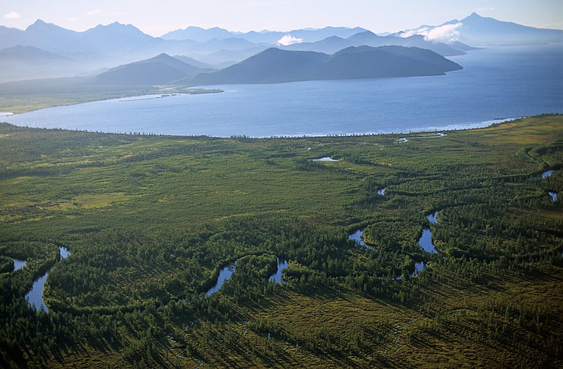
Kronotsky Nature Reserve

Also known as: Кроноцкий заповедник
Nature reserve in Russia. Kronotsky Nature Reserve is a nature area reserved for the study of natural sciences in the remote Russian Far East, on the coast of the Kamchatka Peninsula. It was created in 1934 and its current boundary contains an area of 10,990 km2. The largest lake in the reserve is Lake Kronotskoye, which covers an area of 246 square kilometres. It also has Russia's only geyser basin, plus several mountain ranges with numerous volcanoes, both active and extinct. Due to its often harsh climate and its mix of volcanoes and geysers, it is frequently described as the Land of Fire and Ice.
Kronotsky is mainly accessible only to scientists, plus approximately 3,000 tourists annually who pay a fee equivalent to US$700 to travel by helicopter for a single day's visit. It is part of Volcanoes of Kamchatka, a UNESCO World Heritage Site.[9]