Discover 15 hidden attractions, cool sights, and unusual things to do in Sequoia and Kings Canyon National Parks (United States). Don't miss out on these must-see attractions: General Sherman Tree, Giant Forest Museum, and Vandever Mountain. Also, be sure to include Chief Sequoyah in your itinerary.
Below, you can find the list of the most amazing places you should visit in Sequoia and Kings Canyon National Parks (California).
Table of Contents
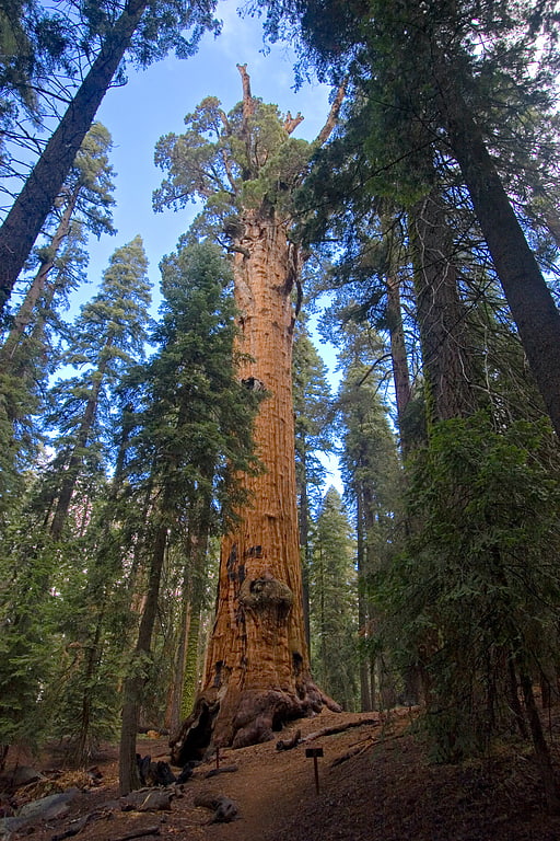
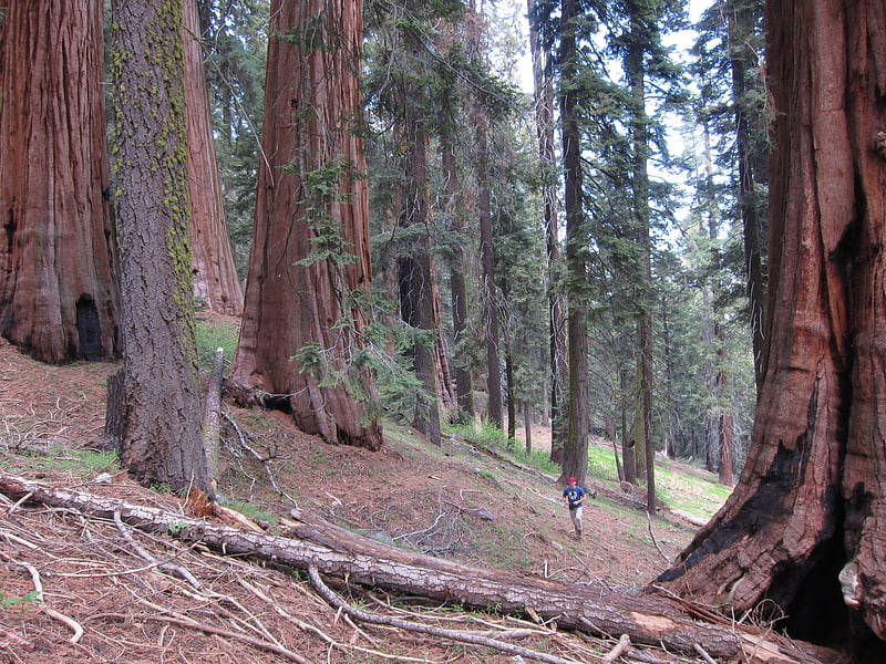
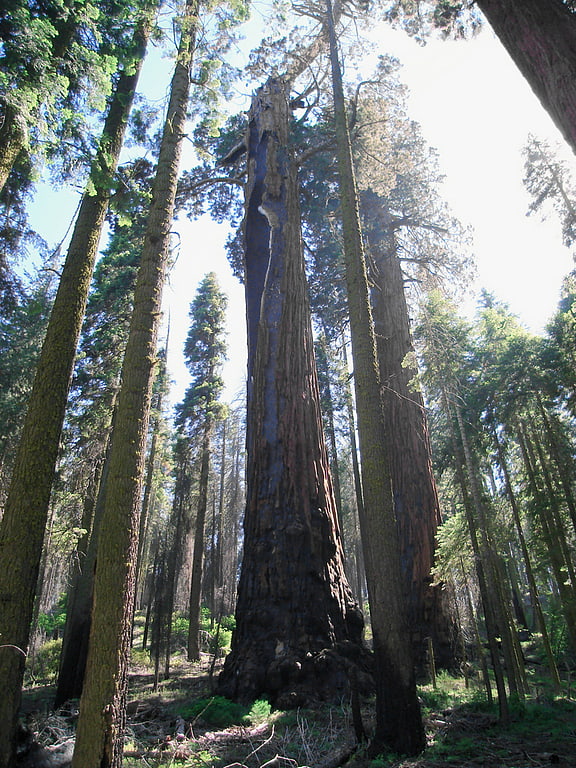
General Sherman Tree
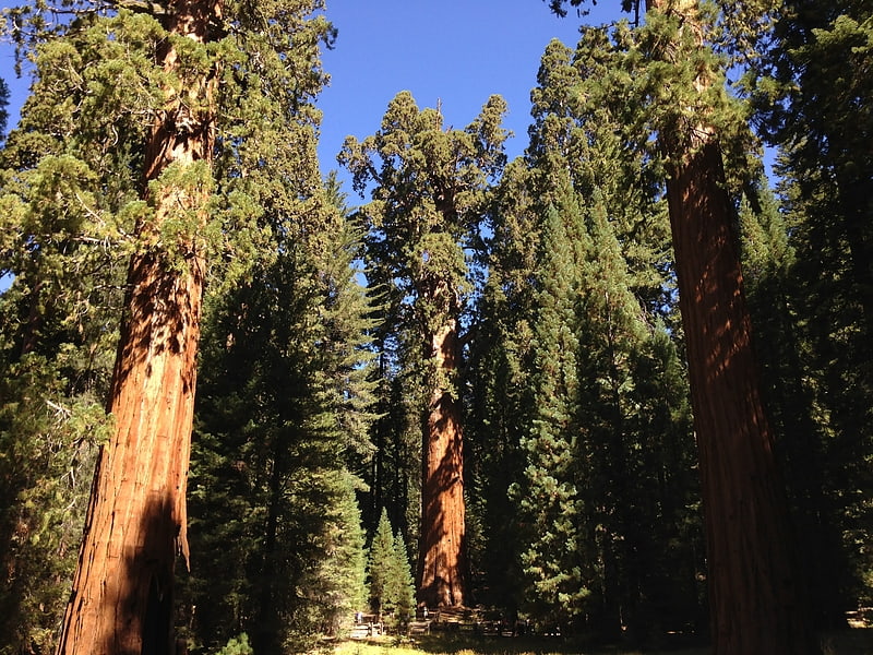
Sequoia National Park’s main attraction. General Sherman is a giant sequoia tree located in the Giant Forest of Sequoia National Park in Tulare County, in the U.S. state of California. By volume, it is the largest known living single-stem tree on Earth. It is estimated to be around 2,200 to 2,700 years old.
While the General Sherman is the largest currently living tree, it is not the largest historically recorded tree. The Lindsey Creek tree, with more than 90,000 cubic feet (2,500 cubic meters) almost twice the volume of General Sherman, was reported felled by a storm in 1905. Another larger coast redwood, the Crannell Creek Giant, a coast redwood (Sequoia sempervirens) cut down in the mid-1940s near Trinidad, California, is estimated to have been 15–25% larger than the General Sherman tree by volume.[1]
Giant Forest Museum
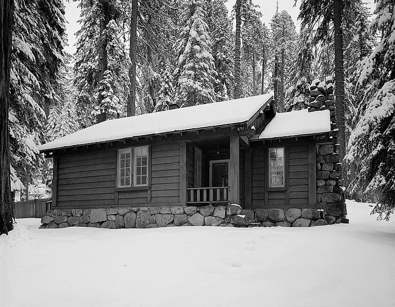
Village in California. The Giant Forest Village–Camp Kaweah Historic District is located in Sequoia National Park. It is notable as one of two registered historic districts in the park that were largely demolished as part of National Park Service efforts to mitigate the impact of park visitor facilities on the park's giant sequoia groves. They were in a vernacular National Park Service Rustic and American Craftsman Bungalow style.
Established in 1926 as a satellite facility for the main Giant Forest Lodge development, Camp Kaweah and Giant Forest Village provided lodging, concessions and camping for visitors to the Giant Forest grove. The construction of the Generals Highway gave impetus to new accommodations in the area. By 2001 the housekeeping camp facilities had been removed and the area converted to a day-use are.[2]
Address: Hwy 198, Giant Forest, Sequoia and Kings Canyon National Parks
Vandever Mountain
Vandever Mountain is an 11,947-foot-elevation mountain summit located in the Sierra Nevada mountain range, in Tulare County of northern California. It is situated on the shared boundary of Sequoia National Park with Sequoia National Forest, four miles south of Mineral King, and 1.78 mile west of Florence Peak, the nearest higher neighbor. Vandever Mountain ranks as the 439th highest summit in California. Topographic relief is significant as the south aspect rises 2,000 feet above White Chief Canyon in one mile. The summit can be reached via class 2 hiking from Farewell Gap or White Chief Canyon.[3]
Chief Sequoyah
Chief Sequoyah is a giant sequoia located within the Giant Forest of Sequoia National Park in California. It is the 9th largest tree in Giant Forest grove, the 27th largest giant sequoia in the world, and could be considered the 26th largest depending on how badly Ishi Giant atrophied during the Rough Fire in 2015.[4]
Garfield Grove
Garfield Grove is a Giant Sequoia grove near the town of Three Rivers, California. The entire 2,902 acres lies in Sequoia National Park in the Sierra Nevada range in eastern California in the United States.
In December 2001, the neighboring Dillonwood Grove was purchased by the Save The Redwoods League for $10.3 million and added to Sequoia National Park. Prior to the purchase, the Dillonwood Grove was the largest grove in private ownership. The two groves are botanically the same and now managed as a single grove.[5]
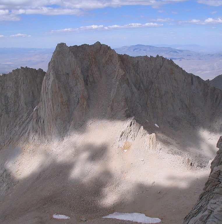
Mount Langley
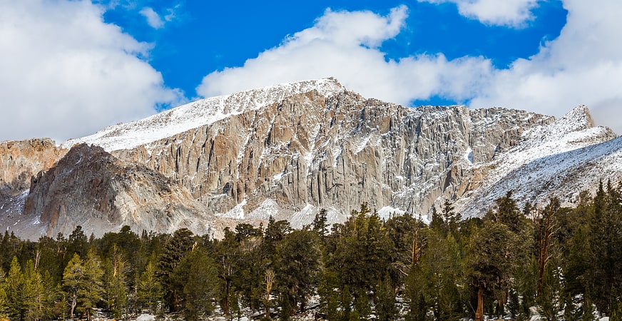
Mountain in California. Mount Langley is a mountain located on the crest of the Sierra Nevada, on the boundary between Inyo and Tulare counties in eastern California, in the United States. To the east is the Owens Valley, and to the west is the Kern River Valley. It is the ninth-highest peak in the state and the seventh-highest in the Sierra. Mount Whitney, the highest peak in the contiguous United States, lies 4.8 miles to the northwest. Mount Langley also has the distinction of being the southernmost fourteener in the United States.[6]
Lippincott Mountain
Lippincott Mountain is a 12,265-foot-elevation mountain summit located on the Great Western Divide of the Sierra Nevada mountain range, in Tulare County of northern California. It is situated in Sequoia National Park, 1.5 mile north of Mount Eisen, and 1.7 mile south of Eagle Scout Peak. Topographic relief is significant as the east aspect rises 2,660 feet above Big Arroyo in 1.5 mile. Lippincott Mountain ranks as the 351st highest summit in California. The High Sierra Trail traverses below the eastern slope of this mountain, providing an approach option. The southeast slope and east ridge are class 2, and the northwest ridge is a class 3 scramble.[7]
Mount Eisen
Summit in California. Mount Eisen is a 12,185-foot-elevation double summit mountain located on the Great Western Divide of the Sierra Nevada mountain range, in Tulare County of northern California. It is situated in Sequoia National Park, 1.6 mile south of Lippincott Mountain. Mount Eisen ranks as the 380th highest summit in California. Topographic relief is significant as the south aspect rises 3,500 feet above Pinto Lake in one mile. The summit can be reached from the southeast ridge via a long class 2 hike from Black Rock Pass.[8]
Hazelwood Tree
The Hazelwood Tree is a giant sequoia in the Giant Forest, the sequoia grove where the largest living tree in the world, named General Sherman, grows. It is located on a hillside just west of the Hazelwood Nature Trail. The tree had a volume of 36,228 cu ft and was the 17th largest giant sequoia, before losing half its trunk in a lightning storm in 2002. The tree was measured in 1989.[9]
Needham Mountain
Mountain. Needham Mountain is a mountain summit of the Sierra Nevada, located in Tulare County, California. It is located in the southern Sierra Nevada, in the central part of Sequoia National Park. Needham Mountain is 6 mi miles east of Mineral King, 5.6 mi northeast of Mount Kaweah, and 17 mi southwest of the highest peak in the state, Mount Whitney. With an altitude of 12,536 ft, Needham Mountain is the twentieth-highest mountain in California with a prominence of 1,880 ft. The mountain is named after an American congressman who represented California at the turn of the 19th and 20th centuries, James C. Needham. The first ascent of the summit was made in July 1916, by M. R. Parsons, Agnes Vaile, H. B. Graham, and Edmund Chamberlain.[10]
Eagle Scout Peak
Mountain in California. Eagle Scout Peak is a 12,005-foot mountain on the Great Western Divide of the southern Sierra Nevada. The mountain is located in the backcountry of Sequoia National Park. The mountain sits immediately to the south of Kaweah Gap along the main crest of the Great Western Divide. The east face of Eagle Scout Peak is relatively gentle and offers the easiest routes to the summit. The north face drops 1,600 feet to Precipice Lake in a series of sheer cliffs. This scene was the backdrop for the Ansel Adams photo "Frozen Lake and Cliffs".
The main route to the summit is a YDS Class 2 scramble up the east face from the Big Arroyo. Two technical climbing routes exist on the steep north face: "Dancing Deer Direct" and "North Face". Both these routes have YDS Class 5.7 difficulty. On July 15, 1926 Francis Farquhar and three Eagle Scouts (Frederick Armstrong, Eugene Howell, and Coe Swift) made the first recorded ascent of Eagle Scout Peak, hence its name.
Eagle Scout Peak does not have particularly high topographic prominence due to a high-elevation ridge connecting it to several higher peaks to the south. However, the sheer vertical drop on the north face makes the mountain visually prominent. Its position along the ridge of the Great Western Divide endows the mountain with panoramic views in all directions. Eagle Scout Peak is featured on the peak list maintained by the Sierra Peaks Section.[11]
Generals' Highway Stone Bridges
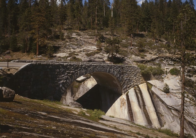
The Generals' Highway Stone Bridges, built in 1930, are part of the Generals' Highway from the General Grant Grove of giant sequoias in Kings Canyon National Park through Sequoia National Park. One bridge spans the Marble Fork of the Kaweah River in a wooded setting, while the other, similar bridge spans Clover Creek in a bare canyon.[12]
Midway Mountain
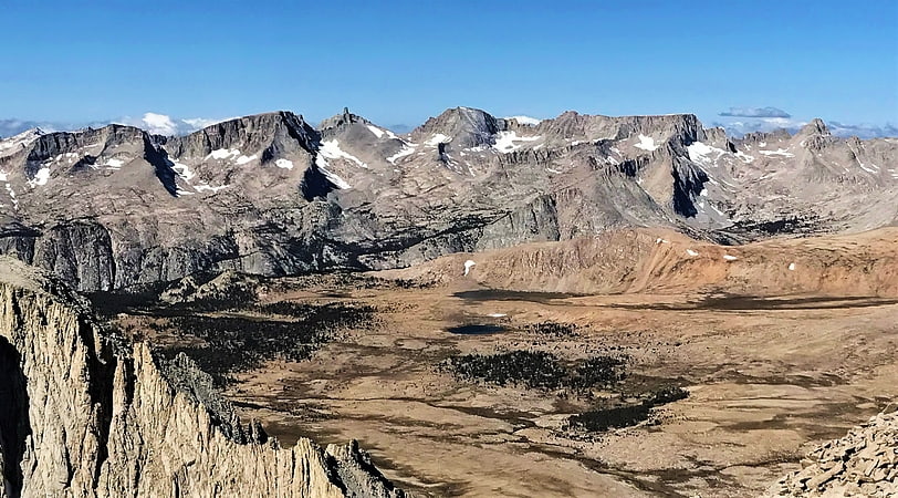
Midway Mountain is a remote 13,665-foot-elevation mountain summit located on the Great Western Divide of the Sierra Nevada mountain range, in Tulare County of northern California. It is set on the common boundary that Kings Canyon National Park shares with Sequoia National Park, and is situated 0.6 mile southwest of Table Mountain, and 0.6 mile north of Milestone Mountain. Midway Mountain ranks as the 39th-highest summit in California, and the highest point on the central Great Western Divide. It would be the highest of the entire Great Western Divide if the Kaweah Peaks were excluded. Topographic relief is significant as the west aspect rises over 4,800 feet above Cloud Canyon in three miles, and the east aspect rises over 3,800 feet above the Kern River in three miles.[13]
Mount Russell
Peak in California. Mount Russell is a peak in the Sierra Nevada mountain range in the U.S. state of California, about 0.8 miles north of Mount Whitney. With an elevation of 14,094 feet it is the seventh-highest peak in the state.[14]
Alta Peak
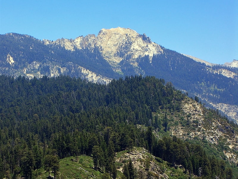
Mountain in California. Alta Peak is in Sequoia National Park not far from Giant Forest. Before 1896, the mountain was known as Tharps Peak. By 1903 it was generally known by its current name and Alta Peak appears on the Tehipite quadrangle, USGS 30 minute topographic map of 1905, and was officially recognized by the Board on Geographic Names in 1928. The Sierra Club Bulletin noted that the name Alta Peak was "euphonious". A meadow on its southern slope had long been known as Alta Meadow. A rocky outcrop, 0.5 miles southwest of the summit, is now known as Tharps Rock. Hale Tharp was the first euro-American to explore the Giant Forest area. His summer camp, a hollowed out Sequoia log near Crescent Meadow known as Tharp's Log, is popular with park visitors.[15]