Discover 9 hidden attractions, cool sights, and unusual things to do in Mount Hood Wilderness (United States). Don't miss out on these must-see attractions: Wallalute Falls, Coalman Glacier, and White River Glacier. Also, be sure to include Sandy Glacier in your itinerary.
Below, you can find the list of the most amazing places you should visit in Mount Hood Wilderness (Oregon).
Table of Contents
Wallalute Falls
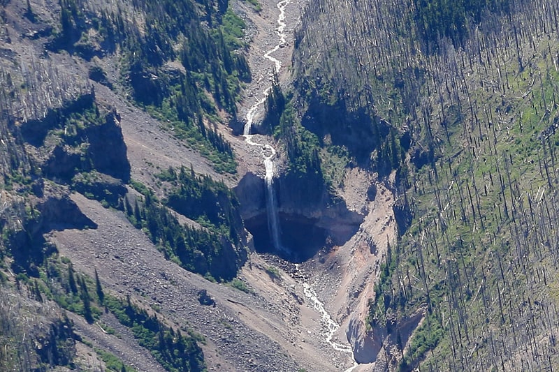
Waterfall in Oregon. Wallalute Falls is a large waterfall located on Compass Creek on the north slopes of Mount Hood in the Hood River County, Oregon, at an elevation of 4,879 feet. For many years maps have mislabeled the location of Wallalute Falls locating it on the Eliot Branch of the West Fork Hood River, one canyon over from Compass Creek where it is still labeled on maps today. Historical documentation in Jack Grauer's book A Complete History of Mt Hood, however, provides 1890s-era photos of two waterfalls located in this area, one labeled Wallalute and one labeled "Strawnahans", where only "Strawnahans" Falls is a photographic match to the actual waterfall located on the Eliot Branch visible from the Cloud Cap road at Inspiration Point.
Photos published on Internet hiking forum OregonHikers.org in 2011 have provided the first modern documented photographs of the large falls located on Compass Creek. According to Jack Grauers book, the original name of the falls on the Eliot Branch is "Strawnahans" Falls but the photograph captioned "Wallalute" Falls had no modern photographic match. Photographs taken during the 2011 explorations of Compass Creek provide an exact match between the largest waterfall located on Compass Creek and the 1890s Wallalute Falls photograph, proving that the maps are mis-labeled.
The name Wallalute is a local Native American name meaning "strong water" and was chosen as the name for the large falls on Compass Creek by local pioneer Ann Lang.
The actual height of Wallalute Falls on Compass Creek is as yet unknown. There is another smaller waterfall just downstream of the original Wallalute historically named Canon Balls Falls located adjacent to a place referenced as "Adam's Hole". Shortly after the 2011 explorations of Compass Creek's canyon, The Dollar Lake Fire burned most of this area.[1]
Coalman Glacier
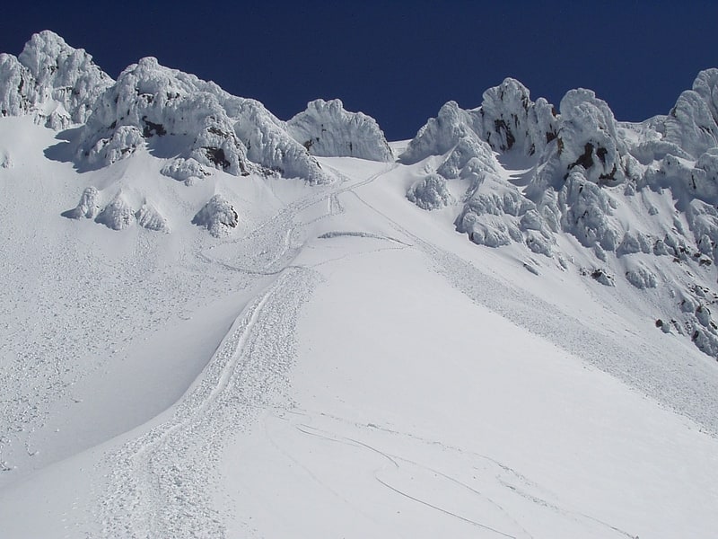
Glacier in Oregon. The Coalman Glacier is a glacier located on the upper slopes of Mount Hood in the U.S. state of Oregon. It is the mountain's highest glacier ranging from about 11,200 to 10,500 ft, located within the crater rim, southwest of the peak. It was named for Elija Coalman, an early mountain guide who climbed Mount Hood 586 times.
Coalman Glacier is the second most frequently visited glacier on the mountain because it is part of the popular South Climbing route from Timberline Lodge. It lies entirely within Mount Hood Wilderness. The most well known feature of Coalman is the Hogsback: a snow ridge running southwest to northeast from Crater Rock toward the summit ridge. The Bergschrund is another widely known feature where the glacier pulls away from the stagnant ice leaving a large crevasse. In 2007, it had become large enough to cause most climbers to use another route.
The glacier is a remnant of the massive glaciers that formed during the last ice age. It is historically known to change configuration dramatically, at times a gradual, smooth surface to Hot Rocks; at other times the same place has a 40 ft (12 m) ice cliff.
The glacier flows southwest, and is bounded on the north and east by the summit, on the northwest by the rocky crater wall known as Castle Crags (also Hawkins Cliffs), on the west by Hot Rocks, and on southeast by the back side of Steel Cliff.[2]
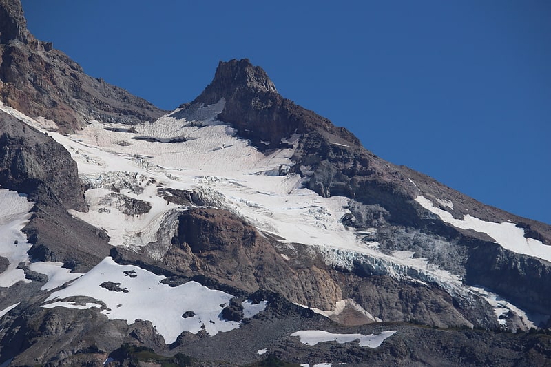
White River Glacier
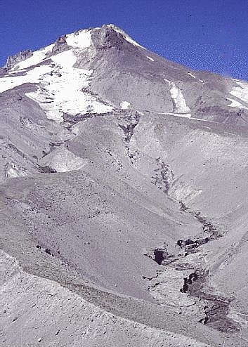
Glacier in Oregon. White River Glacier is an alpine glacier located on the south slopes of Mount Hood in the U.S. state of Oregon. It ranges in elevation from about 10,000 to 6,200 feet. It is among the best known of the twelve glaciers on the mountain, and the lower reaches are a popular destination for Nordic skiing enthusiasts. The glacier is the source of the White River, a tributary of the Deschutes River, and has a long history of washing out the bridge where Oregon Route 35 crosses at 45.30307°N 121.67208°W / 45.30307; -121.67208.
The glacier is a remnant of the massive glaciers that formed during the last ice age and have created White River Canyon. The canyon divides the two largest ski areas on Mount Hood, and is easily seen from many areas of Timberline Lodge ski area, and from the upper southern runs of Mount Hood Meadows. The glacier is bounded on the east by a ridge shared with Newton Clark Glacier and on the west by a ridge shared with Palmer Glacier. The upper glacier forms at the base of Steel Cliff to the east of an area known as Triangle Moraine. The glacier lies almost entirely within Mount Hood Wilderness.
The western edge of the canyon is extremely steep and in times of low visibility causes descending mountain climbers on the South Route (through Palmer Glacier to Timberline Lodge) to veer excessively to the west to avoid the possibility of entering the canyon. This has resulted in numerous search and rescue operations near or in Zigzag Canyon, west of Palmer Glacier. (See Mount Hood climbing accidents.)
Jökulhlaups originating from White River Glacier occurred in 1926, 1931, 1946, 1949, 1959, and 1968. These washed out Highway 35 (or its predecessor) each time. An increase of outbursts from White River Glacier may be related to increasing temperatures and the size of the fumarole field at the glacier's head at Crater Rock. The White River Glacier has decreased in area by 61% between 1907 and 2004. The glacier terminus has retreated 510 metres (1,670 ft) over the same time period.[3]
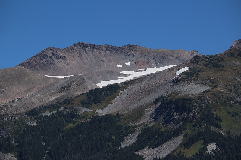
Sandy Glacier
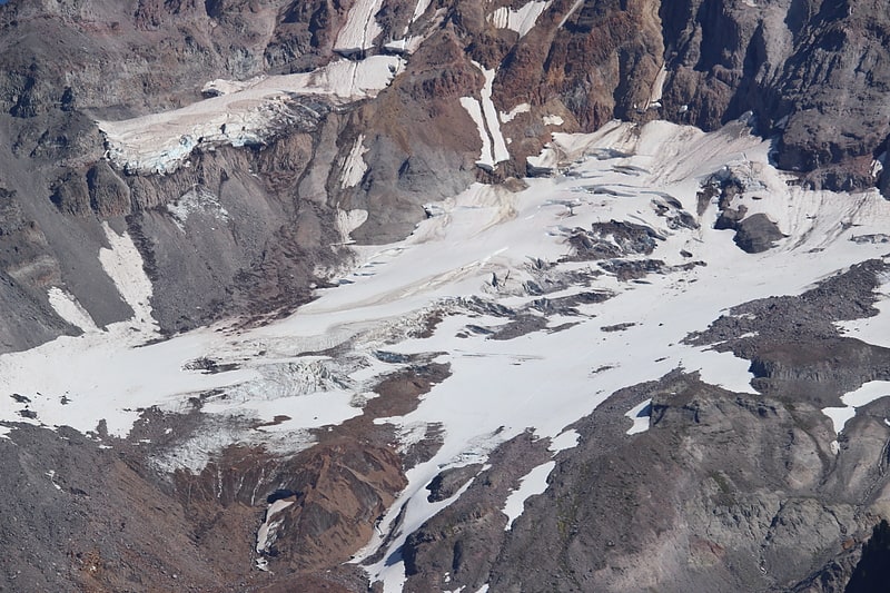
Glacier in Oregon. Sandy Glacier is an alpine glacier located on the west slope of Mount Hood in the U.S. state of Oregon. It extends in elevation from about 8,800 to 6,000 feet. The glacier is the source of Muddy Fork, a tributary of the Sandy River. The upper extent of the glacier is known for extensive crevasses. The lower extent was marked by the Sandy Glacier Caves, possibly the largest glacier cave system in the lower 48 U.S. states.
The glacier is a remnant of the massive glaciers that formed during the last ice age. It is bounded on the south by Yocum Ridge which also defines the northern side of Reid Glacier, and by a ridge on the north which defines part of the Hood River-Clackamas county border which also bounds the south side of Glisan Glacier. The glacier lies entirely within Mount Hood Wilderness.
Sandy Glacier decreased in area by 40% between 1907 and 2004. The glacier terminus has retreated by 690 metres (2,260 ft) over the same time period.[4]
Reid Glacier
Glacier in Oregon. Reid Glacier is an alpine glacier located on the west slope of Mount Hood in the U.S. state of Oregon. It ranges in elevation from about 9,800 to 6,000 feet. The glacier is the source of the Sandy River. The upper extent of the glacier is known for extensive crevasses.
The glacier is a remnant of the massive glaciers that formed during the last ice age. It is bounded on the north by Yokum Ridge which also defines the southern side of Sandy Glacier, and by a ridge on the south bounding the north side of Zigzag Glacier. The eastern and upper reaches of this ridge include Illumination Rock. The uppermost portion of the glacier is below Leuthold Couloir. The glacier lies entirely within Mount Hood Wilderness.
Between 1907 and 2004, Reid Glacier lost 35% of its surface area. The glacier terminus has retreated by 1,607 feet (490 m) over the same time period.[5]
Ladd Glacier
Glacier in Oregon. Ladd Glacier is an alpine glacier on the north slope of Mount Hood in the U.S. state of Oregon. It lies at an average elevation of 7,500 feet. The glacier lies entirely within Mount Hood Wilderness.
Between 1907 and 2004, Ladd Glacier lost 37% of its surface area and the glacier terminus retreated 1,190 metres (3,900 ft) over the same time period.[6]
Sandy Glacier Caves
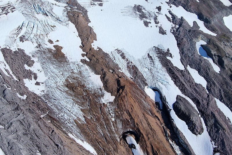
Cave in Oregon. The Sandy Glacier Caves are a system of glacier caves within the ice of Sandy Glacier on Mount Hood, Oregon. They are thought to be the largest glacier caves in the lower 48 states of the United States. Surveys done in 2011 and 2012 have measured the system at over 1 mile in length or about 7,000 feet. The caves formed from internal glacial melting at what are the headwaters of the Muddy Fork river. As melting continues, the caves grow larger with their entrances melting their way up the glacier's slope. Eventually it is predicted the caves will be completely gone within 7 to 10 years once the interior melting has reached the surface of the glacier.
During early summer, all three surveyed caves within the glacier are connected through perennial ice and are called the Snow Dragon Glacier Cave System. By late summer, the perennial ice melts away leaving only the disconnected glacier caves that have been individually named Snow Dragon, Pure Imagination, and Frozen Minotaur Caves. In 2013, a fourth glacier cave was discovered on the Sandy Glacier, but so far it has not been explored.[7]
Upper Sandy Guard Station Cabin
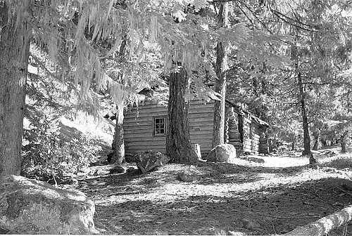
Historical place in Clackamas County, Oregon. The Upper Sandy Guard Station Cabin is a log and stone building built in 1935. It was funded as part of the Federal work relief Emergency Relief Appropriations Act of that year, and also by funds from the City of Portland, Oregon.
It is "an exceptional expression of a 'rugged' Rustic style U.S. Forest Service building", and is the only cabin constructed of its particular design. Out of 700 Forest Service administration buildings built in Oregon and Washington during 1933-1942, it is the only one built with both stone and logs as principal materials.
It was built in 1935 to house an administrative guard who was to prevent intrusions into the area, part of the city of Portland's water supply area. It is located in what is now Mt. Hood National Forest, about 5 miles from Government Camp in Clackamas County, Oregon.
The building was listed on the U.S. National Register of Historic Places in September, 2009. The listing was announced as the featured listing in the National Park Service's weekly list of September 18, 2009. The building was argued to be eligible for NRHP listing by each of several criteria: that it was eligible in the areas "of Conservation for its association with early USDA Forest Service recreation management and its concurrent role in the protection of the Bull Run watershed", in the area of Politics/Government for its association with Franklin D. Roosevelt's New Deal Programs, and in the area of Architecture as a "unique example" of "non-intrusive design philosophy that evolved among land-management agencies during the period of 1933-1942". It was labor-intensive to build and would not have been replicated any time after the onset of World War II.
The building "is also believed to be the only existing cabin with its unique battered corners and mortared stone extension in the Pacific Northwest."
According to the National Park Service:
The Upper Sandy Guard Station Cabin, built in 1935, is an exceptional expression of a "rugged" Rustic style U.S. Forest Service building constructed by skilled local carpenters and laborers assisted by men employed under one of President Franklin D. Roosevelt's New Deal work relief programs. Funded by the Emergency Relief Appropriations (ERA) Act of 1935, and cooperating funds from the City of Portland, the cabin was built along the newly constructed Timberline Trail specifically to provide housing for an administrative guard to protect the Bull Run Division watershed, the source of the City of Portland's drinking water supply, from public entry. The guard station is no longer used as an administrative site and is now located within the Mt. Hood Wilderness and is managed by the Zigzag Ranger District of the Mt. Hood National Forest.[8]
Mount Hood
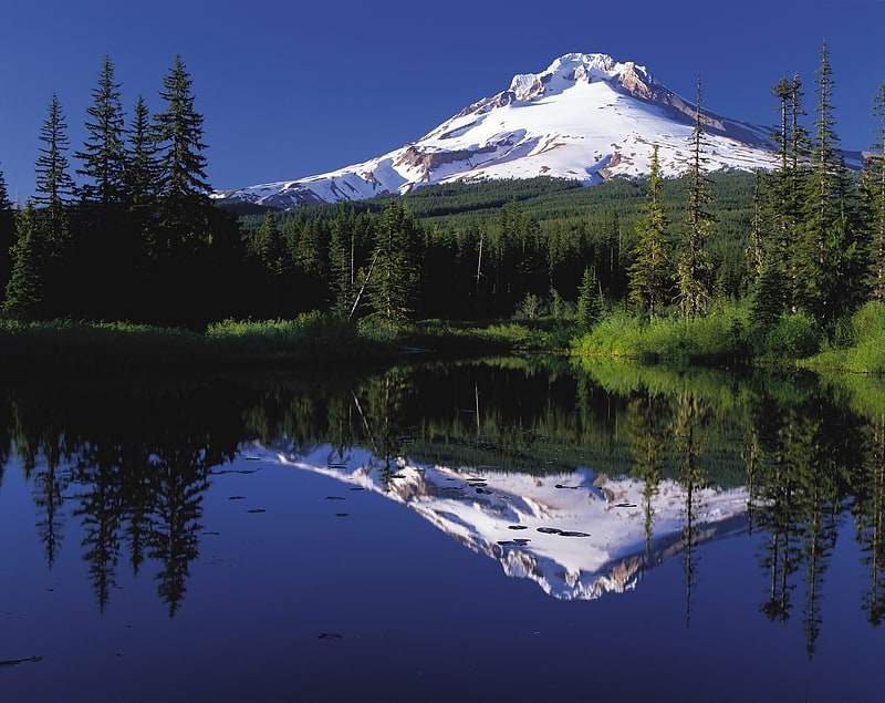
Volcanic mountain with Timberline Lodge. Mount Hood is a potentially active stratovolcano in the Cascade Volcanic Arc. It was formed by a subduction zone on the Pacific coast and rests in the Pacific Northwest region of the United States. It is located about 50 miles east-southeast of Portland, on the border between Clackamas and Hood River counties. In addition to being Oregon's highest mountain, it is one of the loftiest mountains in the nation based on its prominence, and it offers the only year-round lift-served skiing in North America.
The height assigned to Mount Hood's snow-covered peak has varied over its history. Modern sources point to three different heights: 11,249 feet (3,429 m), a 1991 adjustment of a 1986 measurement by the U.S. National Geodetic Survey (NGS), 11,240 feet (3,426 m) based on a 1993 scientific expedition, and 11,239 feet (3,425.6 m) of slightly older origin. The peak is home to 12 named glaciers and snowfields. It is the highest point in Oregon and the fourth highest in the Cascade Range. Mount Hood is considered the Oregon volcano most likely to erupt, though based on its history, an explosive eruption is unlikely. Still, the odds of an eruption in the next 30 years are estimated at between 3 and 7%, so the U.S. Geological Survey (USGS) characterizes it as "potentially active", but the mountain is informally considered dormant.[9]