Discover 10 hidden attractions, cool sights, and unusual things to do in Lincoln National Forest (United States). Don't miss out on these must-see attractions: Sitting Bull Falls, Apache Point Observatory, and Bonito Lake. Also, be sure to include Monjeau Lookout in your itinerary.
Below, you can find the list of the most amazing places you should visit in Lincoln National Forest (New Mexico).
Table of Contents
Sitting Bull Falls
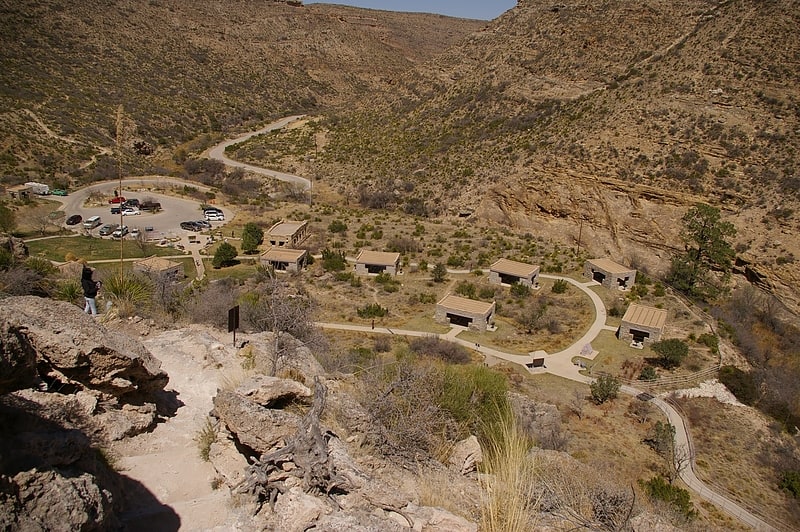
Waterfall in New Mexico. Sitting Bull Falls is a series of waterfalls located in a canyon in the Lincoln National Forest southwest of the city of Carlsbad, New Mexico. The United States Department of Agriculture's Forest Service maintains a popular recreation area for day use at the location of the falls.
The falls are fed by springs located in the canyon above. The water flows through a series of streams and pools until reaching the falls where it drops 150 feet into the canyon below. Most of the water disappears into the gravel or cracks in the rocks and either reappears in springs further down the canyon or joins the Pecos Valley underground water supply.
The area around Sitting Bull Falls is the remnant of a reef system known as the Capitan Great Barrier Reef dating from the Permian period. Approximately 250 million years ago, the region was located near the edge of an inland sea.
The origin of the name Sitting Bull Falls remains uncertain. One version holds that the falls were named after a Sioux medicine man. The Apache name for the area was gostahanagunti which means hidden gulch.
A number of hiking trails allow visitors access to the springs above the falls. A paved path connects the picnic area to the area around the bottom of the falls where wading and swimming are allowed. Additionally, there are a number of caves in the area which require special permits to visit.
In 1940, the Civilian Conservation Corps constructed a number of stone buildings which are part of the parking and picnic area. A time capsule located in front of one of the buildings was dedicated on March 24, 1999 and will be opened on the 100th anniversary of the Civilian Conservation Corps' construction in the area. The day use area was closed from April 27, 2011 through April 6, 2012 due to damage from a wildfire in the area. A number of the shelters were repaired after fire had damaged them. Some signs of the fire can still be seen in the area.[1]
Address: Eddy County Rd 409, Lincoln National Forest
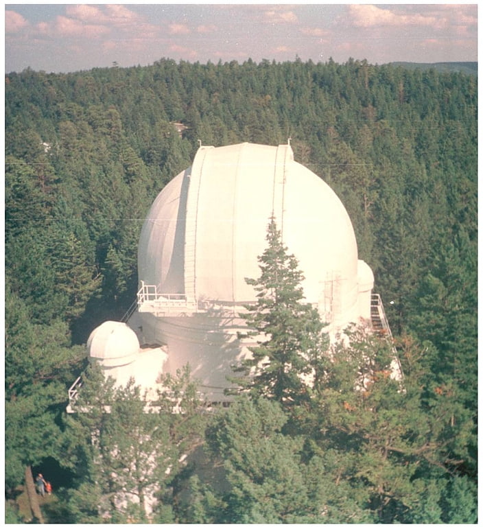
Apache Point Observatory
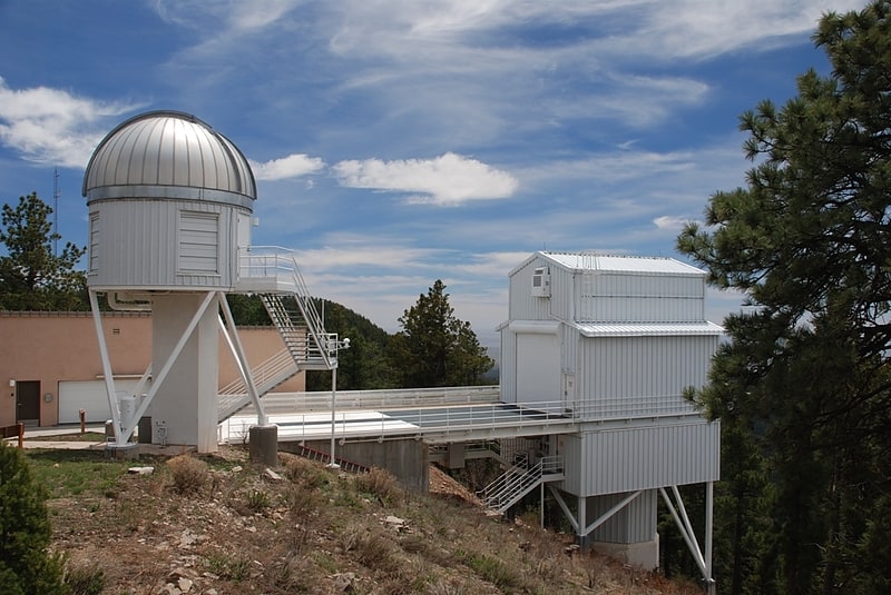
Astronomical observatory. The Apache Point Observatory is an astronomical observatory located in the Sacramento Mountains in Sunspot, New Mexico, United States, approximately 18 miles south of Cloudcroft. The observatory is operated by New Mexico State University and owned by the Astrophysical Research Consortium. Access to the telescopes and buildings is private and restricted.[2]
Address: 2001 Apache Point Road, 88349 Sunspot
Bonito Lake
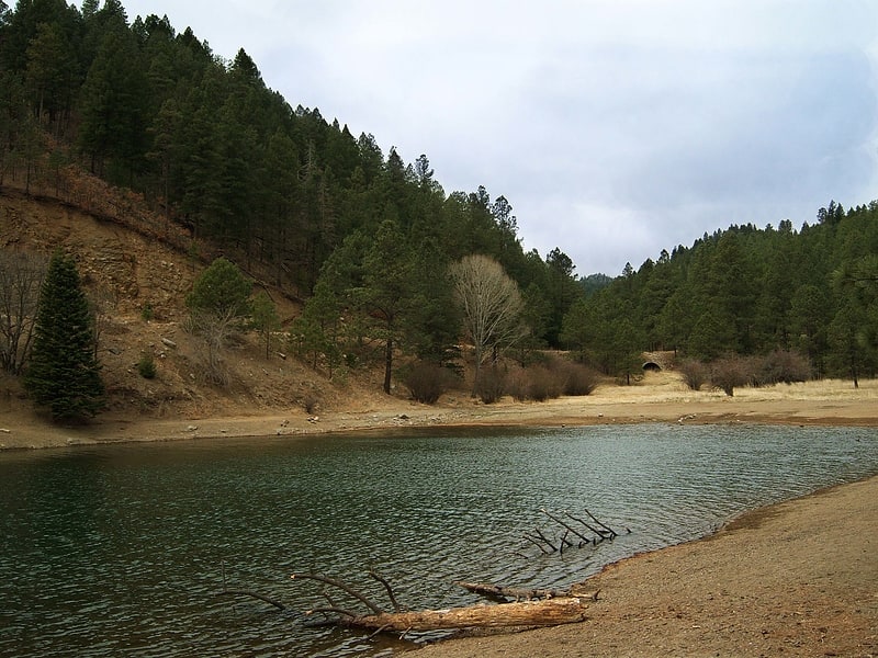
Reservoir in New Mexico. Bonito Lake is an alpine reservoir located high in the Sierra Blanca mountains northwest of Ruidoso, New Mexico. It is a popular fishing and camping destination, and although it is surrounded by the Lincoln National Forest, it is not a part of the national forest. It is currently owned by the city of Alamogordo, New Mexico as their primary water source. Because of the high altitude, the lake's temperature is cold year round, and is home to an abundance of rainbow trout. The area around the lake has several campgrounds with hiking trails and streams.
The area is now a part of the Lincoln National Forest, but in the late 19th century, the Southern Pacific Railroad owned most of the water rights in the area. In 1907 the railroad built a small dam in South Fork Canyon, upstream from the current dam. From that dam they extended a wooden pipeline 132 miles (212 km) to Pastura, New Mexico to provide water for the steam trains of the era. The remnants of the original dam and pieces of the wooden pipeline are still visible to hikers along the trail in South Fork Canyon.
By the 1920s, the railroad needed even more water, and they petitioned the Government of New Mexico to allow them to build another, larger dam along Bonito Creek. The engineers who surveyed the canyon determined that the best place to build a dam would be downstream from the town of Bonito, across a narrow spot in the canyon. This location would allow the dam to contain the water of two streams which merged just above the dam. This location, however, meant that the town of Bonito would be flooded by the dam's lake. The people living in Bonito were given land further down the canyon, and the entire town was moved downstream to a new location.
The dam was completed in 1931, and by 1933 the lake was completely filled. At full capacity, the lake contains 1,500 acre-feet of water.
By the 1950s, steam locomotives had been replaced by diesel electric locomotives, and the railroad no longer needed the water from the lake. The railroad sold the lake to the city of Alamogordo, New Mexico, which needed a reliable water supply to provide the town's drinking water. A 90-mile (140 km) pipeline was built to Alamogordo's "La Luz" water treatment plant. Alamogordo still owns the dam and lake, but all of the land around the lake is a part of the Lincoln National Forest. The lake and the surrounding mountains are now popular for fishing, camping, and hiking.[3]
Monjeau Lookout
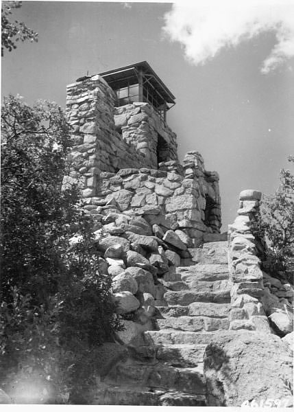
Scenic spot in Lincoln County, New Mexico. Monjeau Lookout was completed in 1940 by the Civilian Conservation Corps to serve as a fire lookout tower within Lincoln National Forest, New Mexico, United States, and remains in active use as a destination for forest visitors. The structure is a 14’ x 14’ native stone tower which contains living quarters, and is topped with a 7’x7’ metal-frame cab.
The structure is listed on the National Register of Historic Places, as well as the New Mexico State Register of Cultural Places.
Monjeau Lookout is reached via a 5.5 mile National Forest gravel road, north of Ruidoso, New Mexico. There are three parking and camping areas a mile or two below the Lookout. The last mile or so of NF117 going up to the Monjeau Lookout is sometimes closed. When that is the case, no vehicle traffic goes to the top and the restroom at the top may also be closed. To reach the structure, one must then hike up the road. As of July 2021, the gate is open, but it was closed for a time in the late summer of 2020.[4]
Wofford Lookout Complex
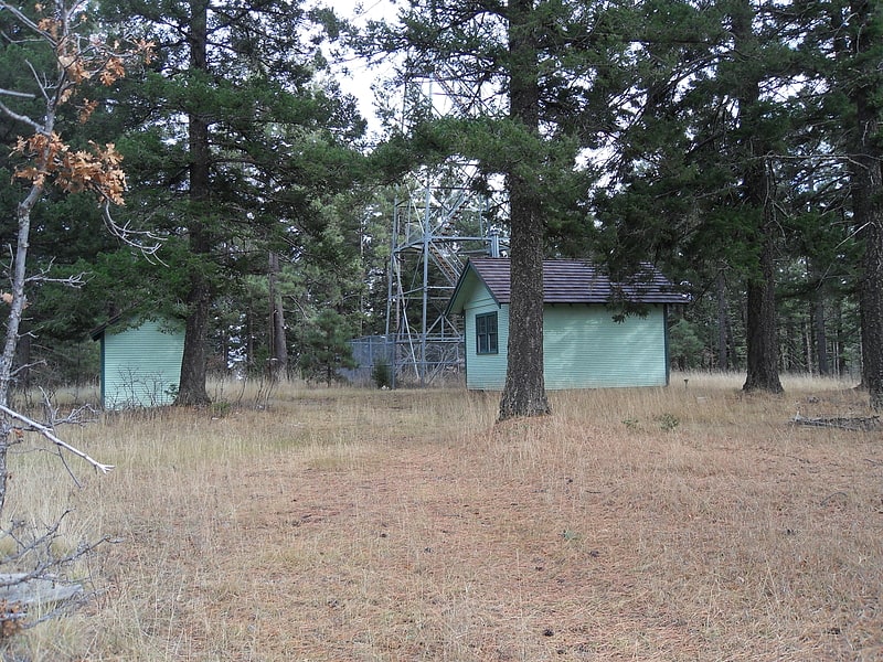
The Wofford Lookout Complex consists of an 80-foot-tall fire lookout tower and associated buildings in Lincoln National Forest in Otero County, New Mexico.
Wofford Lookout Complex was built in 1933 and added to the National Register of Historic Places on January 28, 1988, as part of a thematic group of United States Forest Service fire lookouts in the forest service's Southwestern Region.[5]
Cloudcroft Observatory
Cloudcroft Observatory, is an astronomical observatory located in the Lincoln National Forest near Cloudcroft, New Mexico, approximately 23 kilometers northeast of Alamogordo. It is owned by the Tzec Maun Foundation, a private astronomical organization.
Built in 1962, and known as the Cloudcroft Electro-Optical Research Facility, it was owned by the U.S. Air Force (USAF) until 1982, and initially operated by the Air Force Avionics Laboratory (AFAL). It was used as part of a project to develop new techniques for detecting satellites with electronic imaging devices, which were eventually to replace Project Space Track's Baker-Nunn photographic system. From 1995 to 2002, he facility was known as the NASA Orbital Debris Observatory and hosted two telescopes funded and operated by NASA.[6]
Richard B. Dunn Solar Telescope
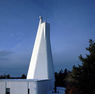
The Dunn Solar Telescope is a unique vertical-axis solar telescope, in Sunspot, New Mexico located at Sacramento Peak, New Mexico. It is the main telescope at the Sunspot Solar Observatory, operated by New Mexico State University in partnership with the National Solar Observatory through funding by the National Science Foundation, the state of New Mexico and private funds from other partners. The Dunn Solar Telescope specializes in high-resolution imaging and spectroscopy to help astrophysicists worldwide obtain a better understanding of how the Sun affects the Earth. Completed in 1969, it was upgraded with high-order adaptive optics in 2004 and remains a highly versatile astrophysical observatory which serves as an important test platform for developing new instrumentation and technologies.[7]
Sacramento Camp and Conference Center
Wayside shrine
Address: 106 Assembly Rd, Lincoln National Forest
Sacramento Mountains
Mountain range in New Mexico. The Sacramento Mountains are a mountain range in the south-central part of the U.S. state of New Mexico, lying just east of Alamogordo in Otero County. From north to south, the Sacramento Mountains extend for 85 miles, and from east to west they encompass 42 miles.[8]
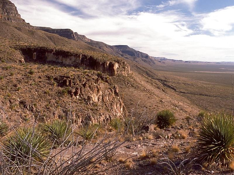
Capitan Mountains
Mountain range in New Mexico. The Capitan Mountains are a mountain range in Lincoln County, in south-central New Mexico in the southwestern United States. The range is about 20 miles long from east to west being about 6 miles wide and were formed from a large elongated granite intrusion similar to the round one that produced Carrizo Mountain to the west.
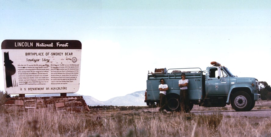
The small town of Capitan is on the southwestern side of the mountain and is the location of Smokey Bear Historical Park. This is the park that memorializes the famous bear that was rescued from the Capitan Gap Fire in the Capitan Mountains. The highest point in the range is an unnamed peak reaching 10,201 feet (3139 m) which is 118 feet (36 m) higher than Capitan Peak. The entirety of the range lies within Lincoln National Forest and is separated from the Sacramento Mountains to the south and Sierra Blanca to the southwest by the valley of Rio Bonito.[9]