Discover 11 hidden attractions, cool sights, and unusual things to do in Wrangell-St. Elias National Park and Preserve (United States). Don't miss out on these must-see attractions: Chitina Tin Shop, Saint Elias Mountains, and Joshua Green Peak. Also, be sure to include Mount Jarvis in your itinerary.
Below, you can find the list of the most amazing places you should visit in Wrangell-St. Elias National Park and Preserve (Alaska).
Table of Contents
Chitina Tin Shop
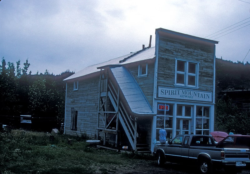
Tourist attraction in the Chitina, Alaska. The Chitina Tin Shop, also known as Fred's Place and Schaupp's, is a historic retail building on Main Street in Chitina, Alaska. It is a wood-frame structure, two stories in height, with a flat-topped false front in front of a gable roof. The building is 17 feet wide and 33 feet deep. It was built in 1912 by Fred Schaupp, during Chitina's building boom following the arrival of the Copper River and Northwestern Railway. The building is one of only a few surviving tin shops in the state. The first floor was occupied by the workshop, while living quarters were above. Following the closing of the railroad in 1938, the building has seen a variety of other uses. The building has been restored, and now houses an art gallery.
The building was listed on the National Register of Historic Places in 1979.[1]
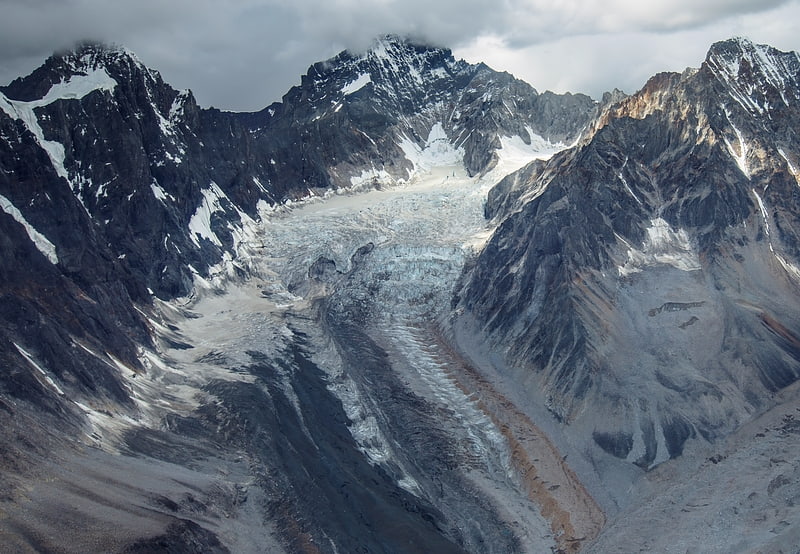
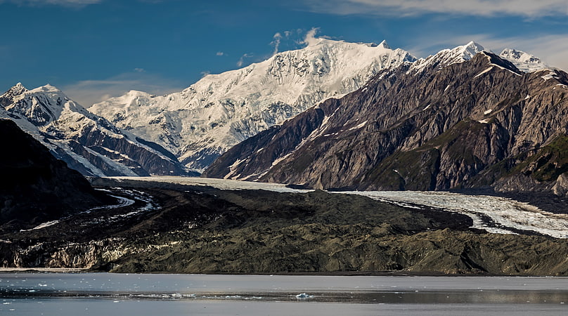
Saint Elias Mountains
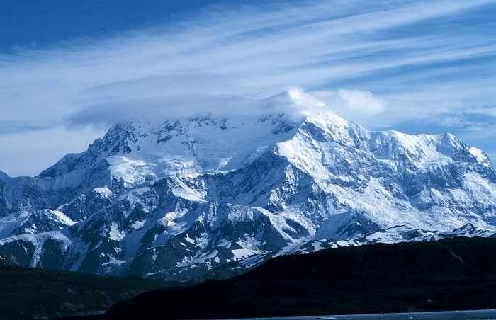
Range in Canada. The Saint Elias Mountains are a subgroup of the Pacific Coast Ranges, located in southeastern Alaska in the United States, Southwestern Yukon and the very far northwestern part of British Columbia in Canada. The range spans Wrangell-St. Elias National Park and Preserve in the United States and Kluane National Park and Reserve in Canada and includes all of Glacier Bay National Park in Alaska. In Alaska, the range includes parts of the city/borough of Yakutat and the Hoonah-Angoon and Valdez-Cordova census areas.
This mountain range is named after Mount Saint Elias, which in turn was named in 1741 by the Danish explorer Vitus Bering.[2]
Joshua Green Peak
Mountain in Alaska. Joshua Green Peak is a 7,135-foot mountain summit located at the western edge of the Saint Elias Mountains, in the U.S. state of Alaska. The peak is situated in Wrangell-St. Elias National Park and Preserve at the head of Dan Creek, 18 mi east-southeast of McCarthy, and 4 mi east-northeast of Williams Peak. The peak is named after Joshua Green, a Seattle businessman who through his financial backing of mining ventures was instrumental in mineral development in the Dan Creek area. The peak's name was officially adopted in 1975 by the U.S. Board on Geographic Names. Precipitation runoff from the mountain drains into Dan Creek which is a tributary of the Nizina River, which in turn is part of the Copper River drainage basin.[3]
Mount Jarvis
Shield volcano in Alaska. Mount Jarvis is an eroded shield volcano in the Wrangell Mountains of eastern Alaska. It is located in Wrangell-Saint Elias National Park about 10 miles east of the summit of Mount Wrangell. The mountain sits at the northeastern edge of the massive ice-covered shield of Wrangell, rising nearly 5,000 feet above it in a spectacular series of cliffs and icefalls.
When seen from above, Mount Jarvis is distinctly dumbbell-shaped, with two prominent peaks connected by a narrower ridge. The mountain's main summit is 13,421 feet (4,091 m), making it one of numerous thirteeners (peaks between 13,000 and 13,999 feet in elevation) in Alaska. The second summit is located about 3 miles (5 km) to the north-northwest, reaching 13,025 feet (3,970 m) with over 725 feet (221 m) of prominence above the connecting saddle, thus qualifying it as an independent peak on the list of thirteeners as well. The entire summit area including both peaks and the ridge is covered in glacial ice. The steep, rocky eastern and western faces of Mount Jarvis form headwalls above the cirques of the Jacksina Glacier and Copper Glacier, which flow northward out of the Wrangell Mountains.
Mount Jarvis was named in 1903 by F. C. Schrader, a USGS geologist, for Lt. David H. Jarvis of the U. S. Revenue Cutter Service, who led the Overland Relief Expedition to aid a whaling fleet trapped in Arctic Ocean ice off Point Barrow in 1897–98.[4]
Ultima Thule Peak
Ultima Thule Peak is a 10,900+ ft glaciated mountain summit located in the Saint Elias Mountains of Wrangell-St. Elias National Park and Preserve, in the U.S. state of Alaska. The peak rises above the Hawkins Glacier to its east, Erickson Creek Glacier to the south, and the Canyon Creek Glacier to the northwest. Precipitation runoff from the mountain drains into tributaries of the Chitina River, which in turn is part of the Copper River drainage basin. The first ascent of the then-unnamed peak was made in 1996 by Paul Claus, Ruedi Homberger, and Reto Reuesh via the south face. Paul Claus dubbed the peak “Ultima Thule Peak.” The second ascent was made April 20, 2013, by Kevin Ditzler and Jay Claus via the southwest ridge.[5]
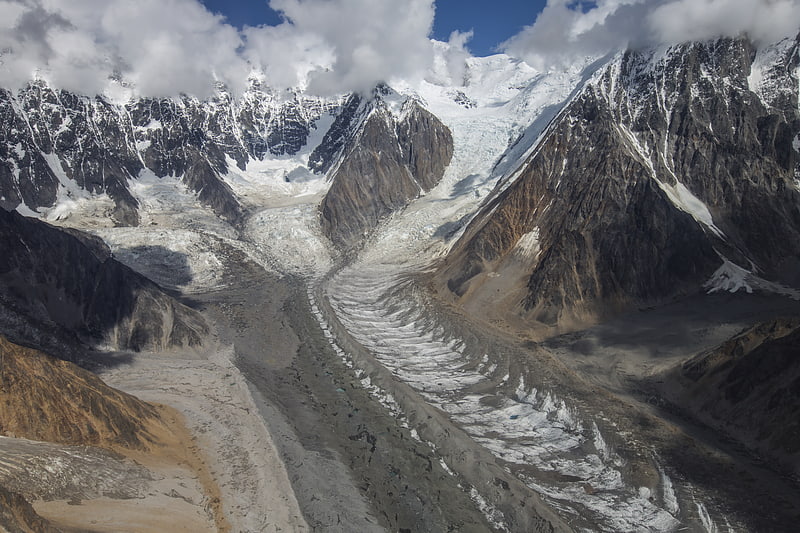
Nabesna Glacier
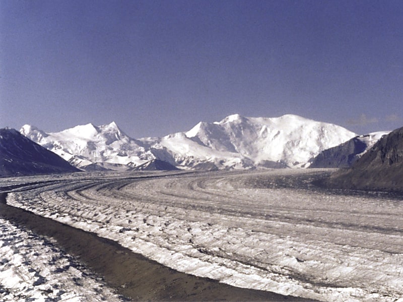
Glacier in Alaska. Nabesna Glacier is a glacier in the U.S. state of Alaska. Fed by deep snowfall in the Wrangell Mountains, the 53 mile long Nabesna is the longest valley glacier in North America and the world's longest interior valley glacier.
The glacier flows from an extensive icefield which covers the northern flanks of 14,163 feet (4,317 m) Mount Wrangell, a large shield volcano. It heads initially east past other volcanic peaks including Mount Blackburn and Atna Peaks and then turns north to its terminus near 3,000 ft (900 m) elevation, about 15 mi (24 km) south of the old mining settlement of Nabesna at the end of the Nabesna Road. The vast expanse and length of the Nabesna is fed by approximately 40 tributary glaciers. Melting ice at its terminus forms the Nabesna River, which flows northward through Tetlin National Wildlife Refuge and into the Tanana River.
The glacier was named for the Nabesna River in 1902 by F. C. Schrader of the U.S. Geological Survey. It provides the normal route of access into the heart of the eastern Wrangell Mountains, for ski mountaineers, climbers, and scientists. Ski-equipped bush planes can typically land between 6,000 and 7,000 ft (1,800-2,100 m) on the central portion of the glacier when the ice and crevasses are covered by winter snow.
The glacier has been undergoing a slow, near-continuous retreat since at least the early 1900s. There is evidence to indicate that this retreat may have been going on even longer than that, as glacial deposits much farther down the valley indicate that it may have once been over 200 miles long.[6]
Haenke Island
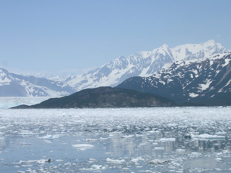
Island in Yakutat, Alaska. Haenke Island is an island located in Disenchantment Bay in Alaska. It was named in 1791 by Alessandro Malaspina for Thaddäus Haenke, who was serving as botanist and naturalist with Malaspina's expedition. The island is part of Yakutat City and Borough.[7]
Icy Bay
Body of water in Alaska. Icy Bay is a body of water in Southeast Alaska, formed in the last 100 years by the rapid retreat of the Guyot, Yahtse, and Tyndall Glaciers. It is part of the Wrangell-Saint Elias Wilderness.
At the beginning of the 20th century, the bay entrance was permanently blocked by a giant tidewater glacier face that calved icebergs directly into the Gulf of Alaska. A century-long glacial retreat has opened a multi-armed bay more than 30 miles (48 km) long.
Icy Bay is a popular destination for sea kayakers, and is reachable by bush plane from Yakutat, Alaska.[8]
Mount Cook
Peak in North America. Mount Cook is a high peak on the Yukon Territory-Alaska border, in the Saint Elias Mountains of North America. It is approximately 15 miles southwest of Mount Vancouver and 35 miles east-southeast of Mount Saint Elias. It forms one of the corners of the jagged border, which is defined to run in straight lines between the major peaks. The same border also separates Kluane National Park in the Yukon Territory from Wrangell-St. Elias National Park and Preserve in Alaska.
Like many peaks of the Saint Elias Mountains, Mount Cook is a massive peak, with a large rise above local terrain. For example, the southwest face drops 10,000 feet (3,048 m) to the Marvine Glacier in approximately 4 miles (6.4 km). It is also quite close to tidewater: Disenchantment Bay is less than 18 miles (29 km) from the summit.
Mount Cook was first climbed in 1953. It is not often climbed due to its remoteness, the size of the mountain, the typically poor weather (due to its proximity to the ocean), and the fact that it is not one of the highest peaks of the range. In fact there are only four references to the peak in the complete index of the American Alpine Journal.[9]
Hawkins Glacier
Glacier in Alaska. Hawkins Glacier is a 22-mile-long glacier in the U.S. state of Alaska. It trends southwest from Mount Bona to its terminus at the Chitina River west of Barnard Glacier, 37 miles southeast of McCarthy.[10]
Chisana
Census-designated place in Alaska. Chisana is a census-designated place in the Copper River Census Area in the U.S. state of Alaska. As of the 2010 Census, the population of the CDP was 0. The English name Chisana derives from the Ahtna Athabascan name Tsetsaan' Na, meaning literally 'copper river'. The Chisana River joins the Nabesna River just north of Northway Junction, Alaska, to form the Tanana River, a major tributary of the Yukon River. The Chisana Airport consists of a turf and gravel runway which is largely serviced by flights from Tok, Alaska.
In 1985, the community was listed as Chisana Historic District on the National Register of Historic Places as a historic district. In 1998 the Chisana Historic Mining Landscape historic district, comprising the community and a wide 27,000 acres (11,000 ha) area located partly in Copper River Census Area and partly in Southeast Fairbanks Census Area, was listed on the National Register of Historic Places.[11]