Discover 11 hidden attractions, cool sights, and unusual things to do in Lake Mead National Recreation Area (United States). Don't miss out on these must-see attractions: Hoover Dam, Lake Mead, and Lake Mohave. Also, be sure to include Black Canyon of the Colorado in your itinerary.
Below, you can find the list of the most amazing places you should visit in Lake Mead National Recreation Area (Arizona).
Table of Contents
Hoover Dam
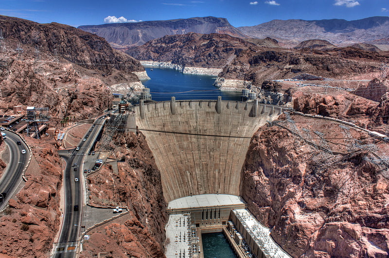
Dam taming the Colorado River since 1935. Hoover Dam is a concrete arch-gravity dam in the Black Canyon of the Colorado River, on the border between the U.S. states of Nevada and Arizona. It was constructed between 1931 and 1936 during the Great Depression and was dedicated on September 30, 1935, by President Franklin D. Roosevelt. Its construction was the result of a massive effort involving thousands of workers, and cost over one hundred lives. It was referred to as Hoover Dam after President Herbert Hoover in bills passed by Congress during its construction, but was named Boulder Dam by the Roosevelt administration. The Hoover Dam name was restored by Congress in 1947.
Since about 1900, the Black Canyon and nearby Boulder Canyon had been investigated for their potential to support a dam that would control floods, provide irrigation water and produce hydroelectric power. In 1928, Congress authorized the project. The winning bid to build the dam was submitted by a consortium called Six Companies, Inc. which began construction of the dam in early 1931. Such a large concrete structure had never been built before, and some of the techniques were unproven. The torrid summer weather and lack of facilities near the site also presented difficulties. Nevertheless, Six Companies turned the dam over to the federal government on March 1, 1936, more than two years ahead of schedule.
Hoover Dam impounds Lake Mead, the largest reservoir in the United States by volume when full. The dam is located near Boulder City, Nevada, a municipality originally constructed for workers on the construction project, about 30 mi (48 km) southeast of Las Vegas, Nevada. The dam's generators provide power for public and private utilities in Nevada, Arizona, and California. Hoover Dam is a major tourist attraction; nearly a million people tour the dam each year. The heavily traveled U.S. Route 93 (US 93) ran along the dam's crest until October 2010, when the Hoover Dam Bypass opened.[1]
Address: Hoover Dam Access Rd, 86443 Boulder City
Lake Mead
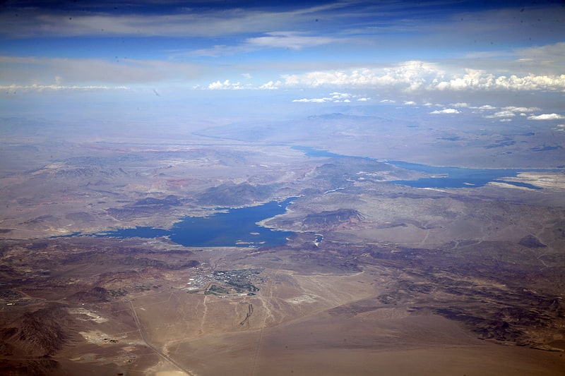
Reservoir in the United States of America. Lake Mead is a reservoir formed by the Hoover Dam on the Colorado River in the Southwestern United States. It is located in the states of Nevada and Arizona, 24 mi east from Las Vegas. It is the largest reservoir in the US in terms of water capacity. Lake Mead serves water to the states of Arizona, California, and Nevada, as well as some of Mexico, providing sustenance to nearly 20 million people and large areas of farmland.
At maximum capacity, Lake Mead is 112 miles (180 km) long and 532 feet (162 m) at its greatest depth. Lake Mead has a surface elevation of 1,229 feet (375 m) above sea level. The surface area is 247 square miles (640 km2), and Lake Mead contains 28.23 million acre-feet (34,820,000 megaliters) of water.
The lake has remained below full capacity since 1983 due to drought and increased water demand. As of 16 March 2022, Lake Mead held 31.01% of full capacity at 8.753 million acre-feet (10,797,000 megaliters), dropping below the reservoir's previous all-time low of 9.328 million acre-feet (11,506,000 megaliters) recorded in July 2016. In a draft 2022 Colorado River annual operating plan, released by the U.S. Bureau of Reclamation, a "Shortage Condition" is expected to be declared for 2022, due to the lake level falling below 1,075 feet (327.7 m), which will result in a projected 4.44% curtailment in downstream water delivery.[2]
Lake Mohave
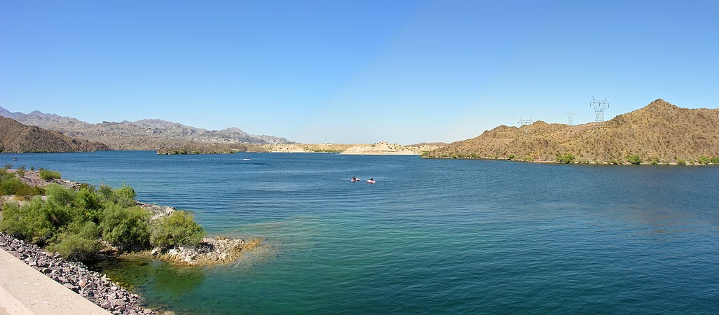
Reservoir in the United States of America. Lake Mohave is a reservoir on the Colorado River between the Hoover Dam and Davis Dam in Cottonwood Valley defining the border between Nevada and Arizona in the United States. This 67 mile stretch of the Colorado River flows past Boulder City, Nelson, Searchlight, Cottonwood Cove, Cal-Nev-Ari, and Laughlin to the west in Nevada and Willow Beach and Bullhead City to the east in Arizona. A maximum width of 4 miles wide and an elevation of 647 feet, Lake Mohave encompasses 28,260 acres of water. As Lake Mead lies to the north of the Hoover Dam, Lake Mohave and adjacent lands forming its shoreline are part of the Lake Mead National Recreation Area administered by the U.S. National Park Service.[3]
Black Canyon of the Colorado
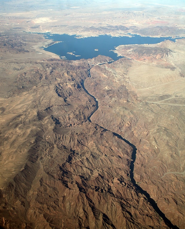
The Black Canyon of the Colorado is the canyon on the Colorado River where Hoover Dam was built. The canyon is located on the Colorado River at the state line between Nevada and Arizona. The western wall of the gorge is in the El Dorado Mountains, and the eastern wall is in the Black Mountains of Arizona. The canyon formed about 15 million years ago during the Miocene Basin and Range uplift. Black Canyon gets its name from the black volcanic rocks that are found throughout the area.
Just south of the Hoover Dam on the Nevada side of the canyon is the Sauna Cave. This cave was drilled by miners working on Hoover Dam while it was being constructed. It is a deep cave with calcium carbonate crystals on the walls. At the end of the cave is a hot spring, which causes temperatures in the cave to reach 120 °F (49 °C).
One prominent canyon that splits from this canyon south of the Hoover Dam is Boy Scout Canyon. Boy Scout Canyon has water running through it that is warmed from a geothermal source.
On the Arizona side of the river, there are several large hot springs that can be found by taking a trail north from a larger bay about 4 to 5 miles (6.4 to 8.0 km) south of the Hoover Dam.[4]
Hoover Dam Lodge
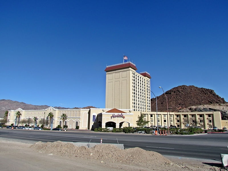
Hoover Dam Lodge is a hotel and casino near Boulder City, Nevada. It is owned and operated by Richard Craig Estey. It was previously the Gold Strike until it was largely destroyed by an accidental fire on June 16, 1998. It reopened the next year as the Hacienda and then took on its current name in January 2015.
The hotel is located on a parcel of private land surrounded by Lake Mead National Recreation Area, three miles from Hoover Dam. It overlooks Lake Mead and has a 17-story tower with 372 rooms.
The 20,782 square feet (1,930.7 m2) casino has 154 slot machines and a race and sports book operated by William Hill.[5]
Address: 18000 US-93, Lake Mead National Recreation Area
Valley of Fire State Park
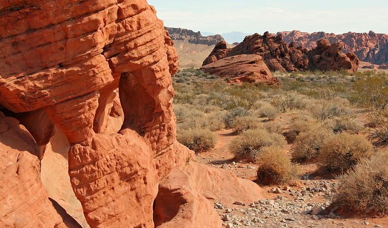
State park in Clark County, Nevada. Valley of Fire State Park is a public recreation and nature preservation area covering nearly 46,000 acres located 16 miles south of Overton, Nevada. The state park derives its name from red sandstone formations, the Aztec Sandstone, which formed from shifting sand dunes 150 million years ago. These features, which are the centerpiece of the park's attractions, often appear to be on fire when reflecting the sun's rays. It is Nevada's oldest state park, as commemorated with Nevada Historical Marker #150. It was designated as a National Natural Landmark in 1968.
Valley of Fire is located 50 miles (80 km) northeast of Las Vegas, at an elevation between 1,320–3,009 feet (402–917 m). It abuts the Lake Mead National Recreation Area on the east at the Virgin River confluence. It lies in a 4 by 6 mi (6.4 by 9.7 km) basin.[6]
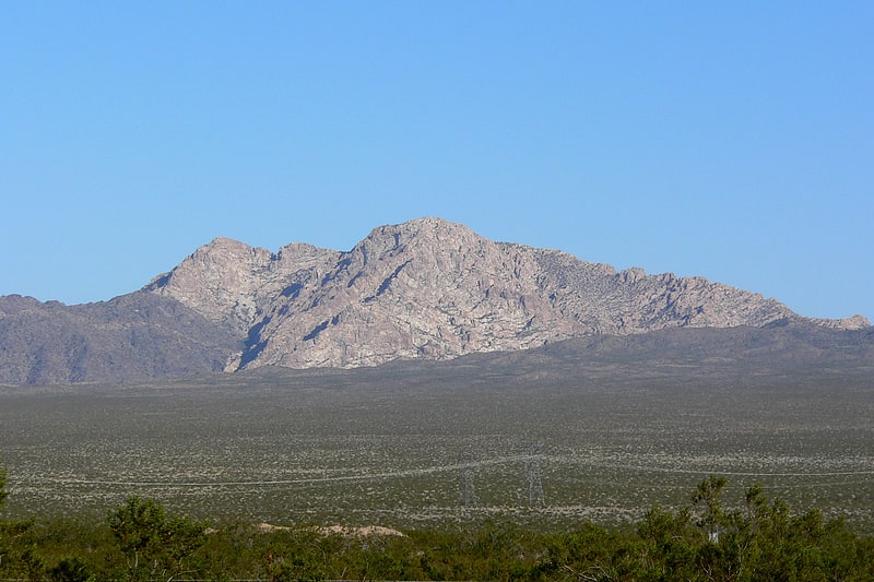
Fortification Hill
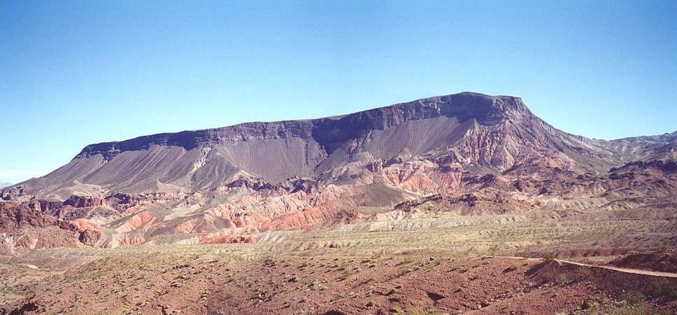
Mountain in Arizona. Fortification Hill is a prominence adjacent to Lake Mead in the Lake Mead National Recreation Area; it is located at the northwest terminus region of the Black Mountains, and specifically the north region of the Black Mountains. It is near a southern section of Lake Mead, and just northeast of Hoover Dam. It can easily be seen eastward across Las Vegas Bay or from the two northern mountain terminuses of Eldorado Mountains, or the Black Mountains.
The mountain prominence is plateau-like, or mesa-like with its highpoint at the southeast terminus, and sloping north and northwestwards toward Lake Mead. The prominence is 3,719 feet (1,134 m).
The flat mountaintop, sloping northwards is composed of Tertiary basaltic lava flows.[7]
Katherine's Landing
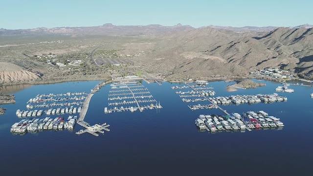
Katherine Landing is a recreational area located on the Arizona side of the Colorado River and Lake Mohave just north of Bullhead City in the Lake Mead National Recreation Area. It is about two miles upstream from Davis Dam and accessed from Arizona State Route 68.
The National Park Service, which administers Katherine Landing, reports more than 1.2 million visitors each year. The area was named after a gold mine popularly known as Katherine Mine that operated in the vicinity in the late 1800s.[8]
Address: 2690 Katherine Spur Rd, Lake Mead National Recreation Area
Grapevine Canyon Petroglyphs
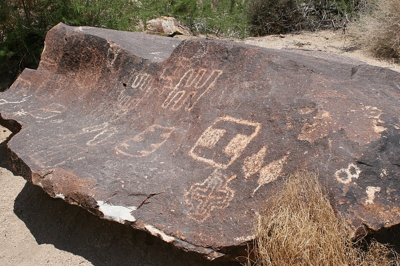
The Grapevine Canyon Petroglyphs are located in Grapevine Canyon on Spirit Mountain near Laughlin, Nevada, and are listed on the United States National Register of Historic Places. The area is also known as Christmas Tree Pass. While the petroglyphs extend through the canyon, a significant concentration lies at the entrance to the canyon which is at an elevation of 2,395 feet. The area features over 700 petroglyphs and many rock shelters.[9]
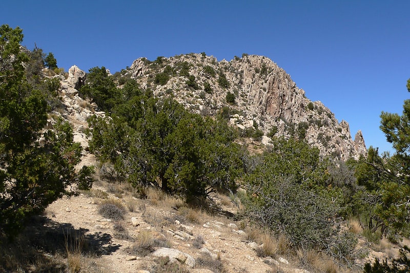
Spirit Mountain
Mountain in Nevada. Spirit Mountain, known as Avi Kwa' Ame in Mojave, is a mountain within the Lake Mead National Recreation Area near Laughlin, Nevada. It is listed on the United States National Register of Historic Places as a sacred place to Native American tribes in Southern Nevada. Spirit Mountain is the highest point in the Spirit Mountain Wilderness and is the highest point in the Newberry Mountains with the summit peak at 5,639 feet.
Environmentalists in Nevada are seeking designation of a significant area to the west of the mountain as a national monument. The monument would be named after the peak as the mountain is visible from almost the entire area.[10]
Address: 8555 S Hwy 95, Lake Mead National Recreation Area
Spirit Mountain Wilderness
County park in Clark County, Nevada. Spirit Mountain Wilderness Area is a 33,518-acre wilderness area located in the Newberry Mountains in Clark County, Nevada, 10 miles northwest of Laughlin. Spirit Mountain lies within the area. It is managed by the Bureau of Land Management and the National Park Service.
Most of the wilderness is located in the Lake Mead National Recreation Area. The area is adjacent to both the Nellis Wash Wilderness Area and the Bridge Canyon Wilderness Area.
The area was in the homeland of the Yuman Indians. Yuman and Mojave people believe all life began on this mountain, which is visible for miles from Bullhead City in Arizona, Needles in California, and Laughlin, Cal-Nev-Ari, and Searchlight in Nevada.
The United States Congress designated the Spirit Mountain Wilderness in 2002.[11]