Discover 11 hidden attractions, cool sights, and unusual things to do in Henry M. Jackson Wilderness (United States). Don't miss out on these must-see attractions: Goat Lake, Blanca Lake, and Sloan Peak. Also, be sure to include Monte Cristo Peak in your itinerary.
Below, you can find the list of the most amazing places you should visit in Henry M. Jackson Wilderness (Washington).
Table of Contents
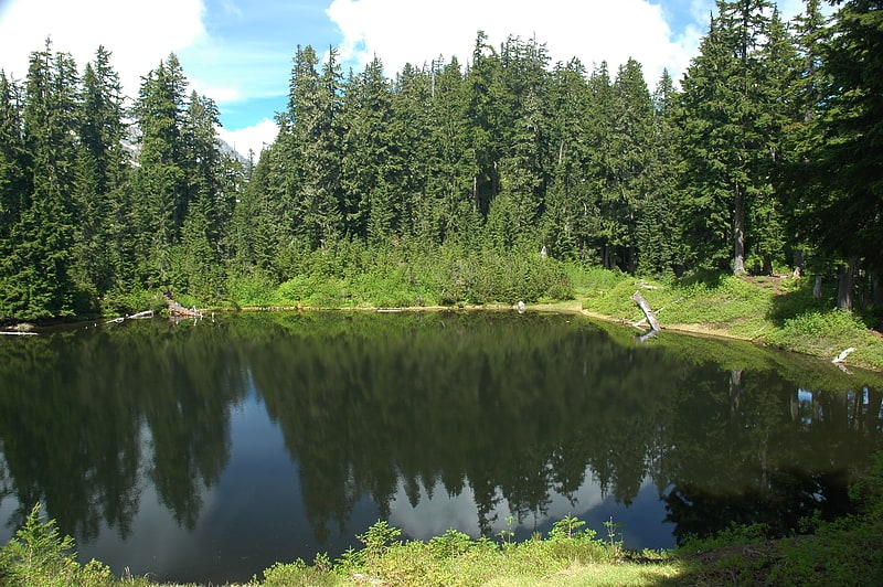
Goat Lake
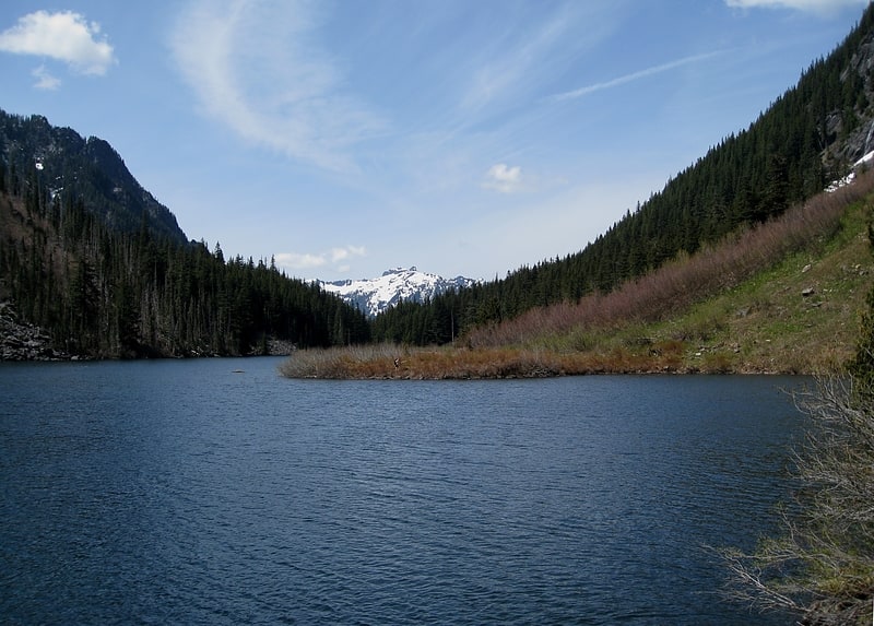
Glacial lake in Washington State. Goat Lake is a glacial lake located in Snohomish County, Washington and in the Mount Baker-Snoqualmie National Forest. The lake is a popular area for hiking, backpacking, and fishing.[1]
Blanca Lake
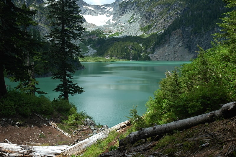
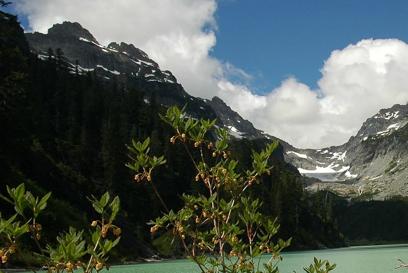
Lake in Washington State. Blanca Lake is located in the Henry M. Jackson Wilderness Area in the Cascade Mountains of the U.S. state of Washington.
Blanca Lake sits in a basin surrounded by the peaks of Monte Cristo, Kyes, and Columbia. The lake is fed by the Columbia Glacier to the northwest and is drained by Troublesome Creek, a tributary of the North Fork Skykomish River. The glacier's cold, silt-filled melt water is what makes the lake a spectacular turquoise green color making this a prime example of a rock flour lake.
Blanca Lake is accessible only by foot, along the Blanca Lake Trail. The trail begins at 1,900 ft (579 m). The trail climbs quickly from switchback to switchback, gaining 2,700 ft (823 m) elevation over 3 mi (4.8 km), finally arriving at the top of a ridge. From the ridge-top, the trail continues through sub-alpine meadows until you reach Virgin Lake at 4,600 ft (1,402 m). From Virgin Lake, the trail gets rocky, and steeply descends 600 ft (183 m) over 0.5 mi (0.8 km) to Blanca Lake. Due to its elevation, and the heavy snowpack of the Pacific Northwest, Blanca Lake is typically only easily accessible from June until the snows of October or November.
Its beauty makes it a very popular destination for hikers, despite the difficult climb up the mountain trail.
To get to the trailhead, take US Forest Road 65/Beckler Road 13.7 mi (22.0 km) near Skykomish, WA to the intersection with US Forest Road 63. Northwest Forest Pass is still required to park and a US Forest Service Daily Fee of $5 per vehicle[2]
Sloan Peak
Mountain in Washington State. Sloan Peak is a 7,835-foot mountain in the North Cascades of Washington state. It rises about 40 miles east of Everett, Washington and 12 miles southwest of Glacier Peak, one of the Cascade stratovolcanoes. It is located between the north and south forks of Sauk River, in the Mount Baker–Snoqualmie National Forest. The summit is situated about 4 miles east of the Mountain Loop Highway.
Sloan Peak has been called the "Matterhorn of the Cascades" for its sharp, high peak, which is accentuated by its impressive local relief and its isolated position west of the Cascade crest. It is easily visible from many locations in the North Cascades. On both the east and southwest sides, Sloan's summit rises more than one vertical mile (1.6 km) above the valley floor in less than two horizontal miles (3.2 km).
The standard route on the peak climbs the South Face and Upper West Face, but it is also known as the "Corkscrew Route" due to its winding nature. It starts on the north side of the peak, and traverses the Sloan Glacier to reach the east edge of the South Face; the route then continues to turn around the peak to reach the summit via the Upper West Face. The usual approach is via Forest Service Road No. 48 and Forest Service Trail No. 649. The trail crosses the North Fork of the Sauk River, and no bridge is provided, although a log may be present. The total elevation gain of the route is 5,935 feet (1,809 m). It involves snow and glacier climbing and some rock scrambling (class 3). Other more technical routes exist on Sloan's other faces.[3]
Monte Cristo Peak

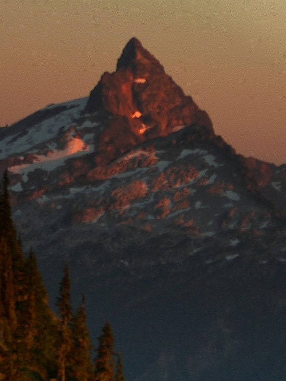
Mountain in Washington State. Monte Cristo Peak is a mountain peak in the Henry M. Jackson Wilderness in Washington state. Together with Columbia Peak and Kyes Peak it forms a basin that contains Columbia Glacier and Blanca Lake. The 1918 edition of The Mountaineer called the mountain "a huge pile of red rock."
Monte Cristo is named for the mining boom town of Monte Cristo, which dates from the late 19th and early 20th centuries and which is situated on the mountain's northwestern flank. The town was owned by J. D. Rockefeller for a few years. A railroad and cable tramway was built to move materials.[4]
Kyes Peak
Peak in Washington State. Kyes Peak, which is also known as "Goblin Peak", is a mountain peak located in the Henry M. Jackson Wilderness in Washington, United States. Kyes Peak rises to over 7,280 feet. Together with Columbia Peak and Monte Cristo Peak it forms a basin that contains Columbia Glacier and Blanca Lake. It is the highest summit in the Monte Cristo group of peaks.
Kyes Peak was once mapped as Goblin Peak, and in earlier times was known by miners and the United States Forest Service as Mount Michigan. The name Kyes comes from a member of the first climbing party, Commander James Ellsworth Kyes. Along with Reginald Bachelder, Kyes climbed the mountain on August 15, 1920. Both were members of the Everett Boy Scouts at the time.
It is uncommon for a Washington Cascades mountain to be named after a person who climbed it. The USGS agreed to posthumously rename the mountain in recognition for Kyes' sacrifice commanding a destroyer in the Battle of the Atlantic. An earlier ascent of the peak was probably made by Thomas Gerdine of the USGS in 1897.[5]
Lake Valhalla

Lake in Washington State. Lake Valhalla is a glacial lake located in the Okanogan-Wenatchee National Forest of the state of Washington. Positioned adjacent to the Pacific Crest Trail, the lake and its surrounding areas are popular for hiking, climbing and other recreational activities.[6]
Virgin Lake
Lake in Washington State. Virgin Lake is a small lake, with moderately clear water, located at the edge of the Henry M. Jackson Wilderness Area along the Blanca Lake Trail in Washington, United States. The lake is 4,577 ft. above sea level.[7]
Mount McCausland
Mountain in Washington State. Mount McCausland is a mountain in the U.S state of Washington located in the Okanogan-Wenatchee National Forest east of Stevens Pass. It's a popular hike that has views of nearby Lake Valhalla and Lichtenberg Mountain.[8]
Lichtenberg Mountain
Mountain in Washington State. Lichtenberg Mountain is a 5,844-foot mountain summit located 2.8 miles north of Stevens Pass in the Okanogan-Wenatchee National Forest of the U.S state of Washington. It rises steeply above the east shore of Lake Valhalla, and less steeply above the west shore of Lichtenwasser Lake. Surface runoff from the mountain drains into tributaries of Nason Creek which in turn is a tributary of the Wenatchee River[9]
Columbia Glacier

Glacier in Washington State. See also Columbia Glacier.
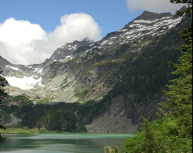
Columbia Glacier is a glacier located in the Henry M. Jackson Wilderness in the U.S. state of Washington. It descends from 5,600 ft to 4,700 ft above sea level. It is surrounded by Columbia Peak, Monte Cristo Peak, and Kyes Peak and is a source of water for Blanca Lake and Troublesome Creek, a tributary of the North Fork Skykomish River.
The glacier retreated 278 ft (85 m) between 1979 and 2004. The retreat is due to recent reduced winter snowpack and more summer melting leading to negative mass balance. The glacier is in disequilibrium with climate and will continue to thin and retreat.[10]
Columbia Peak
Mountain in Washington State. Columbia Peak is a mountain peak in the Henry M. Jackson Wilderness in the U.S. state of Washington. Columbia Peak rises to 7,172 feet. Together with Monte Cristo Peak and Kyes Peak it forms a basin that contains Columbia Glacier and Blanca Lake.[11]