Discover 15 hidden attractions, cool sights, and unusual things to do in Glacier Peak Wilderness (United States). Don't miss out on these must-see attractions: Glacier Peak, Image Lake, and Mount Fernow. Also, be sure to include Bonanza Peak in your itinerary.
Below, you can find the list of the most amazing places you should visit in Glacier Peak Wilderness (Washington).
Table of Contents
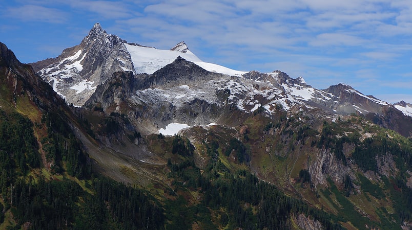
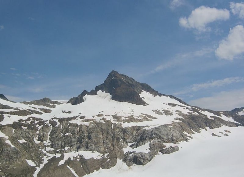
Glacier Peak
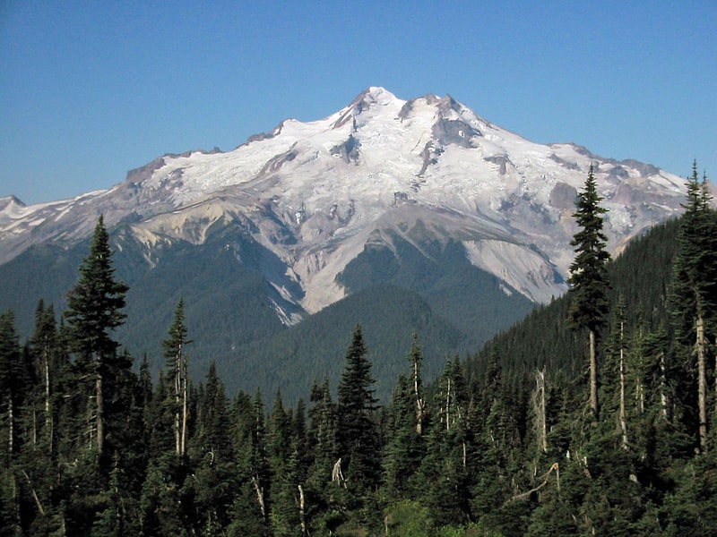
Active volcano with glaciers and hiking. Glacier Peak or Dakobed is the most isolated of the five major stratovolcanoes of the Cascade Volcanic Arc in the U.S state of Washington. Located in the Glacier Peak Wilderness in Mount Baker–Snoqualmie National Forest, the volcano is visible from the west in Seattle, and from the north in the higher areas of eastern suburbs of Vancouver such as Coquitlam, New Westminster and Port Coquitlam. The volcano is the fourth tallest peak in Washington state, and not as much is known about it compared to other volcanoes in the area. Local Native Americans have recognized Glacier Peak and other Washington volcanoes in their histories and stories. When American explorers reached the region, they learned basic information about surrounding landforms, but did not initially understand that Glacier Peak was a volcano. Positioned in Snohomish County, the volcano is only 70 miles northeast of downtown Seattle. From locations in northern Seattle and northward, Glacier Peak is closer than the more famous Mount Rainier, but as Glacier Peak is set farther into the Cascades and almost 4,000 feet shorter, it is much less noticeable than Mount Rainier.
Glacier Peak is one of the most active of Washington's volcanoes. The volcano formed during the Pleistocene epoch, about one million years ago, and since the most recent ice age, it has produced some of the largest and most explosive eruptions in the state. When continental ice sheets retreated from the region, Glacier Peak began to erupt regularly, erupting explosively five times in the past 3,000 years. It has erupted repeatedly during at least six periods; two of these eruptions have been among the largest in Washington.[1]
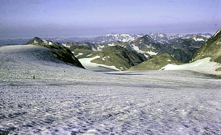
Image Lake
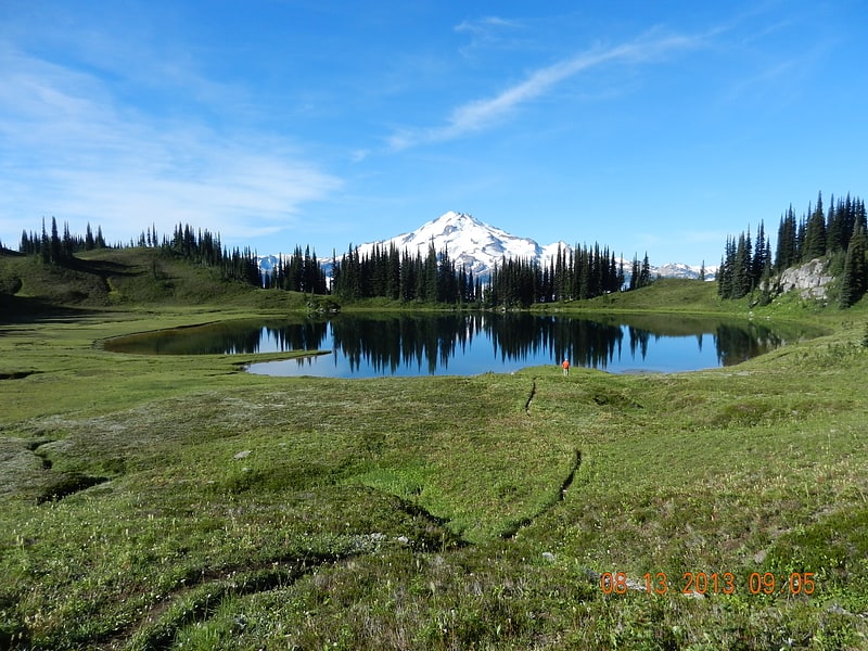
Tarn in Washington. Image Lake is a tarn in Glacier Peak Wilderness, in the North Cascades of Washington, United States. The lake is surrounded by Plummer Peak to the east, a lookout point to the west, the Miners Creek drainage and Glacier Peak to the south, and Canyon Lake to the north. The course of the popular Miners Ridge Trail skirts the lake. Glacier Peak can be seen from the outlet of the lake, and the peak reflected in the lake is a popular photographic subject.
As a result of a relatively mild temperate climate with ample precipitation, the areas around Image Lake boast rich natural habitats with many species of plants, insects, rodents, and large mammals. Native Americans took advantage of these resources, and may have inhabited the area seasonally. However, human activity such as hunting, fishing, and mining, and recreational overuse increased after the arrival of Europeans. As a result, some areas experienced significant environmental degradation near the end of the nineteenth century and the early twentieth century, including the eradication of large predatory animals. Recreational overuse and the presence of livestock were especially problematic in the early to mid-twentieth century.[2]
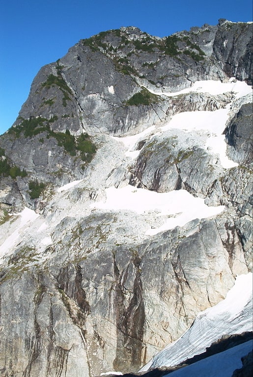
Mount Fernow
Peak in Washington State. Mount Fernow is a tall peak in the North Cascades in the U.S. state of Washington and within the Glacier Peak Wilderness of the Wenatchee National Forest. At 9,249 feet in elevation it is the eighth-highest peak in Washington and the state's third-highest non-volcanic peak. It is also the highest peak of the Entiat Mountains, a sub-range of the Cascades. Mount Fernow's prominence is 2,811 ft, making it the sixtieth-most-prominent peak in Washington. The closest peak to Fernow is Copper Peak, 0.88 mi to the north, and the nearest higher peak is Bonanza Peak, 5.9 mi to the north.
Mount Fernow is flanked by several glaciers. Other large glaciated peaks are nearby, such as Seven Fingered Jack to the south. The headwaters of the Entiat River rise from the south slopes of Mount Fernow and the east slopes of Seven Fingered Jack.[3]
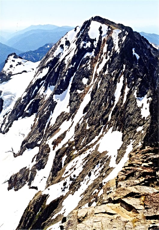
Bonanza Peak
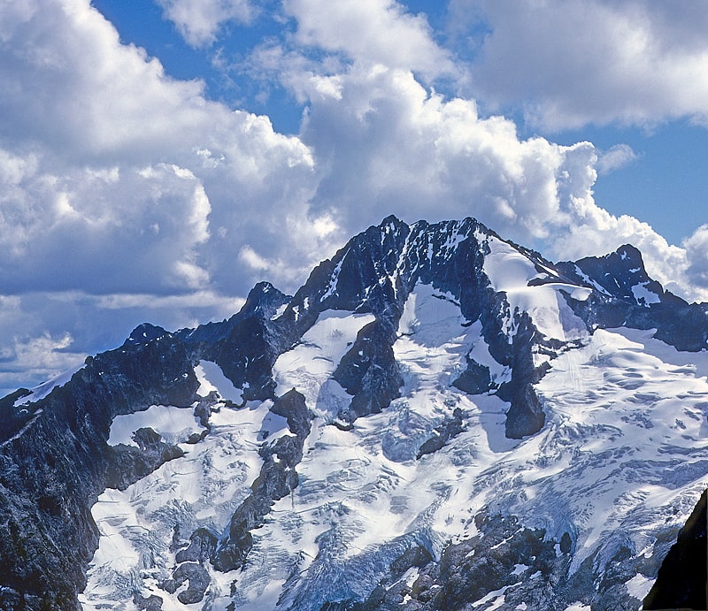
Peak in Washington State. Bonanza Peak is a tall peak in the North Cascades in the U.S. state of Washington and the Glacier Peak Wilderness of the Wenatchee National Forest. At 9,516 feet in elevation, it is the highest point in Chelan County, and the highest non-volcanic peak in Washington and the Cascade Range as a whole. Bonanza Peak's prominence is 3,711 feet, making it the 26th most prominent peak in Washington. The nearest higher peak is Glacier Peak, 14.4 miles to the southwest.
Bonanza Peak is flanked with three large glaciers: Company Glacier to the north, Mary Green Glacier to the east, and Isella Glacier to the south.[4]
Seven Fingered Jack

Mountain in Washington State. Seven Fingered Jack is a mountain in the North Cascades in the U.S. state of Washington. It is located at the north end of the Entiat Mountains, a sub-range of the Cascade Range. It is part of a three-peak group called the Entiat Cirque which includes Mount Maude and Mount Fernow. Seven Fingered Jack is about 4 miles south of Holden. The peak is in the Glacier Peak Wilderness of Wenatchee National Forest.[5]
Mount Pugh
Peak in Washington State. Mount Pugh is a peak near the western edge of the North Cascades, in Washington state. It is located 12.2 miles west of Glacier Peak, one of the Cascade stratovolcanoes. It rises out of the confluence of the White Chuck River and the Sauk River, giving it very low footings. For example, it rises 6,150 feet above the Sauk River Valley in just over 2 horizontal miles; its rise over the White Chuck River is almost as dramatic. The mountain is named for John Pugh, who settled nearby, in 1891.
According to Fred Beckey, "Nels Bruseth apparently made the first ascent in 1916". Earlier unrecorded ascents, including possibly much earlier Native American ascents, are possibilities, since the easiest ascent route is non-technical.
The trail to the summit is easily negotiable most of the way but the last 1.5 miles (2.4 km) is along a razorback ridge with significant exposure. This is the Northwest Ridge, Trail Number 644, which actually starts in the Sauk River Valley on the southwest side of the mountain. The total elevation gain is almost exactly one mile (5,280 ft or 1,609 m).[6]
Mount Maude
Peak in Washington State. Mount Maude is the 15th highest peak in Washington state. The peak is located in the Entiat Mountains, a subrange of the North Cascades. It is in the Glacier Peak Wilderness, at the headwaters of the Entiat River. The peak was given its name by Albert H. Sylvester in honor of Frederick Stanley Maude.
The mountain from the south side consists of mostly talus with small rocky outcroppings, often compared with mountains in the Colorado Rockies. The northeast side is much different, with a steep rocky summit sheltering the small Entiat Glacier. Most climbers will climb Maude, Seven Fingered Jack, and sometimes Mount Fernow in the same trip.[7]
Dome Peak
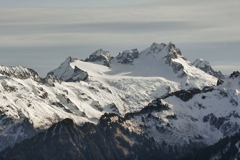
Mountain in Washington State. Dome Peak is a high, massive, glaciated mountain in the Glacier Peak Wilderness of Washington's North Cascades. The remote location of Dome Peak, combined with its height, make it a less common destination for Cascade Range mountaineers. Dome Peak is at the southern end of the Ptarmigan Traverse mountaineering route. It is located at the extreme southeast corner of Skagit County. The mountain was given its name by Albert H. Sylvester, the first forest supervisor of Wenatchee National Forest.
There are two main summits connected by a narrow ridge with the northeastern summit being higher than the southwestern. Chickamin Glacier is north of the peak while Dome Glacier is to the west. A rock face drops off to the southeast. Dana Glacier is on the north side of a ridge that connects Dome Peak and Spire Point.
The higher northeast peak was first climbed by George Freed and Eric Larson on August 1, 1936. The southwest peak was first climbed on July 5, 1936, by Forest Farr, Norval Grigg, and Don Blair.[8]
Fortress Mountain
Peak in Washington State. Fortress Mountain is a 8,671-foot peak in the Cascade Range located about 15 miles west of Lake Chelan in Chelan/Snohomish Counties, Washington, United States. It straddles the border between the Mount Baker-Snoqualmie National Forest and the Wenatchee National Forest, and is also part of the Glacier Peak Wilderness. Fortress Mountain is the highest point on Chiwawa Ridge, and other notable peaks on this ridge include Napeequa Peak, Buck Mountain, Brahma Peak, Bandit Peak, Mount Berge, Helmet Butte, and Chiwawa Mountain.[9]
Wenatchee National Forest
National forest in Washington State. Wenatchee National Forest is a U.S. National Forest located in Washington. With an area of 1,735,394 acres, it extends about 137 miles along the eastern slopes of the Cascade Range of Washington, USA from Okanogan National Forest to Gifford Pinchot National Forest. The forest is located in Chelan, Kittitas and Yakima counties.[10]
Clark Mountain
Mountain in Washington State. Clark Mountain is in Wenatchee National Forests in the U.S. state of Washington. Clark Mountain is the tallest peak in the Dakobed Range and lies 8 mi southeast of Glacier Peak. Richardson Glacier descends to the northeast of the summit, while Clark Glacier lies on the east slopes. Luahna Peak lies 1.04 mi to the northwest.[11]
Mount Formidable
Mountain in Washington State. Mount Formidable is a mountain in the North Cascades of Skagit County, in Washington state. Its first ascent was undertaken by members of the original Ptarmigan Traverse, and the peak is a popular climb for parties on the traverse. It was named by early mountaineer Herman Ulrichs in 1935 because of the rugged appearance of its north face. The peak is usually accessed from Cascade Pass via the Ptarmigan Traverse.[12]
South Cascade Glacier
Glacier in Washington State. South Cascade Glacier is a large alpine glacier in the North Cascades of Washington, USA. It is bordered on the east by 8,261-foot Sentinel Peak, and is about 17 mi north of Glacier Peak in the Glacier Peak Wilderness. Meltwater from the glacier flows directly into South Cascade Lake, which feeds the South Fork Cascade River, which is a tributary of the Skagit River.
South Cascade Glacier is one of the four "benchmark glaciers" that is monitored by the USGS and its mass balance has been monitored since 1959. Its area has declined from 2.71 km2 in 1958 to 1.8 km2 in 2015 representing an area loss of 34%. Between 1958 and 2009 South Cascade Glacier lost nearly a half of its volume.[13]
White Chuck Glacier
Glacier in Washington State. White Chuck Glacier is located in the Glacier Peak Wilderness in the U.S. state of Washington and is 3.5 mi south of Glacier Peak. The glacier is within Mount Baker-Snoqualmie National Forest and nearly touches the White River Glacier though they are separated by an arête off the Kololo Peaks. White Chuck Glacier has retreated significantly since the end of the Little Ice Age. From about 1850 to 1930, the glacier thinned and by 1940, a fast rate of retreat commenced. By 1955, the glacier had three separate termini and by 2005, the northern terminus was gone. Several small proglacial lakes have been left behind by the retreating glacier. Between 1958 and 2005 White Chuck Glacier lost more than half its surface area.[14]
Sentinel Peak
Mountain in Washington State. Sentinel Peak is a 8,266-foot mountain located in the Glacier Peak Wilderness of Washington's North Cascades. The summit is part of the Ptarmigan Traverse. The mountain is situated on the crest of the Cascade Range, on the shared border of Snohomish County and Chelan County, also straddling the boundary between the Mount Baker-Snoqualmie National Forest and the Wenatchee National Forest. The South Cascade Glacier lies below its western slope, and the LeConte Glacier lies on the northeast slope. Its nearest higher peak is Spire Point, 3.03 mi to the south-southwest.[15]