Discover 11 hidden attractions, cool sights, and unusual things to do in Mount Baker–Snoqualmie National Forest (United States). Don't miss out on these must-see attractions: Nooksack Falls, Weeks Falls, and Big Four Ice Caves. Also, be sure to include Bridal Veil Falls in your itinerary.
Below, you can find the list of the most amazing places you should visit in Mount Baker–Snoqualmie National Forest (Washington).
Table of Contents
Nooksack Falls
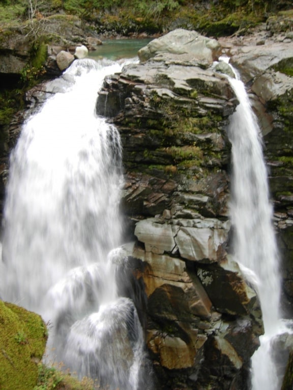
Waterfall in Washington State. Nooksack Falls is a waterfall along the North Fork of the Nooksack River in Whatcom County, Washington. The water flows through a narrow valley and drops freely 88 feet into a deep rocky river canyon. The falls are viewable from the forested cover near the cliffs edge. The falls are a short 2/3 of a mile drive off the Mount Baker Highway, Washington. The falls were featured in the hunting scene of the movie The Deer Hunter.[1]
Weeks Falls
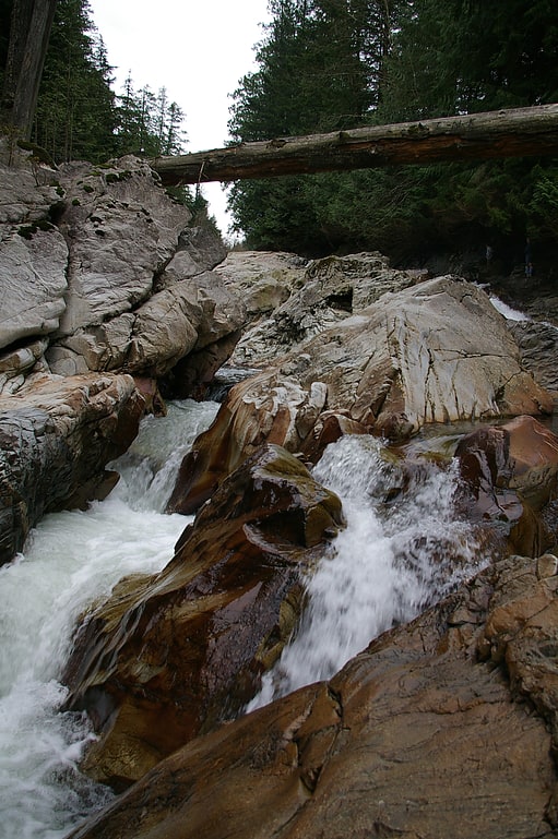
Waterfall in Washington State. Weeks Falls is a waterfall on the South fork of the Snoqualmie River, located just south of Interstate 90 at exit 38. The falls are at the end of the road that goes past the Olallie State Park ranger headquarters. From the gravel parking lot, there is a paved accessible overlook to see the falls and a small area around the hydro-electric plant. Also, there is a 1/4 mile accessible interpretive trail nearby.
Weeks Falls has a small hydroelectric plant operated by CHI West which generates about 4.3 Megawatts peak. It's unusual because it operates without a dam. Instead, water is being drawn from the river above the falls and run down an underground channel to the generation unit at the bottom of Weeks falls.[2]
Big Four Ice Caves
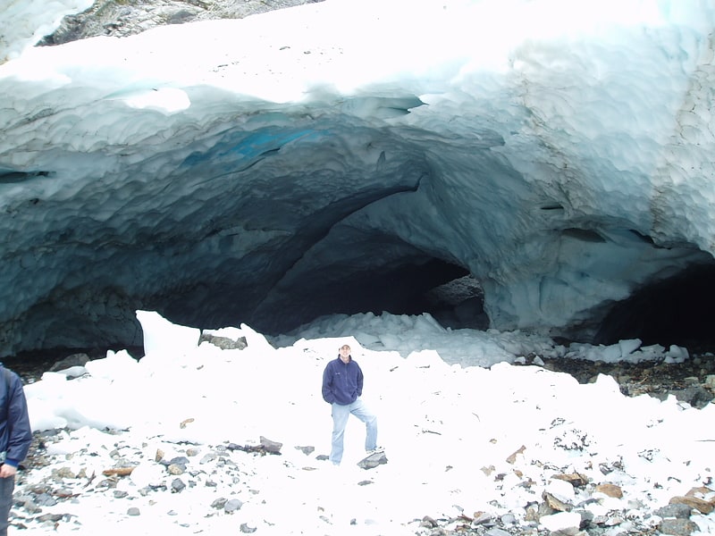
Tourist attraction in Snohomish County, Washington. Big Four Mountain is a mountain in the Cascade Range of Washington, located 21 miles east of Granite Falls. The mountain is about 6,180 ft high. At the bottom of its steep, 4,200 ft high north face, debris piles form from avalanches and are able to remain there year round because of the continuous shade provided by the mountain. At an elevation between 2,450 ft and 1,950 ft, this ice forms the lowest-elevation glacier in the lower 49 states. During the summer, snow-melt streams flow beneath the debris piles and cause caves to be formed in the ice.
The Big Four Ice Caves Trail, a designated National Recreation Trail, (#723) is one of the most popular hikes in the Mount Baker-Snoqualmie National Forest attracting over 50,000 visitors per year. Frequently exceeding several hundred hikers per day, the trailhead's two separate parking areas are often filled beyond capacity occasionally forcing hikers to park along neighboring Mountain Loop Road.
A severe autumn storm in November 2006 caused flooding of the South Fork Stillaguamish River destroying a major footbridge to the Big Four Ice Caves. Estimated repair costs to replace the damaged span were approximately $425,000, and repairs were completed in June 2009. While the trail is open to the public, the snowfield itself was closed temporarily due to cave-ins and slides which have killed four hikers in incidents in 1998, 2010, and in 2015. Because of the danger, hikers are advised to stay out of the caves.[3]
Bridal Veil Falls
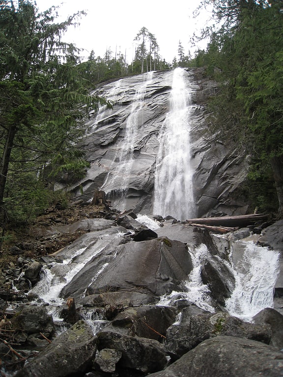
Waterfall in Washington State. Bridal Veil Falls is a 1,328-foot waterfall that flows from Lake Serene directly to the South Fork Skykomish River on the creek of the same name in the U.S. state of Washington. It is a perennial 150-foot wide drop with four tiers, two of which are clearly visible. It is at 47.78950°N 121.56924°W / 47.78950; -121.56924.
Bridal Veil Falls is part of the Mount Baker-Snoqualmie National Forest. A hiking trail leads from a parking area to the falls.[4]
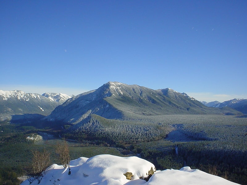
Vesper Peak
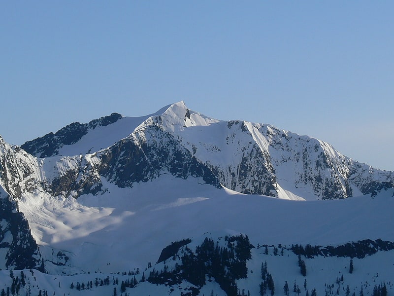
Peak in Washington State. Vesper Peak is a peak along the Mountain Loop Highway region of the North Cascades of Washington state. It is about 18 miles south of Darrington and 21 miles east of Granite Falls, in the Mount Baker-Snoqualmie National Forest. Its gentle south and east slopes contrast with a sheer north face which offers "excellent technical routes".[5]
McClellan Butte
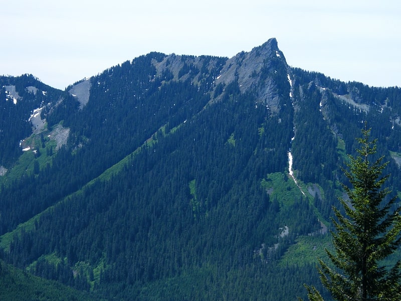
Peak in Washington State. McClellan Butte is a prominent peak in the Cascade Range in King County, Washington 11 miles east of North Bend. The McClellan Butte hiking trail is a difficult trail known as an alternative to Mount Si's crowded trail.[6]
Olallie State Park
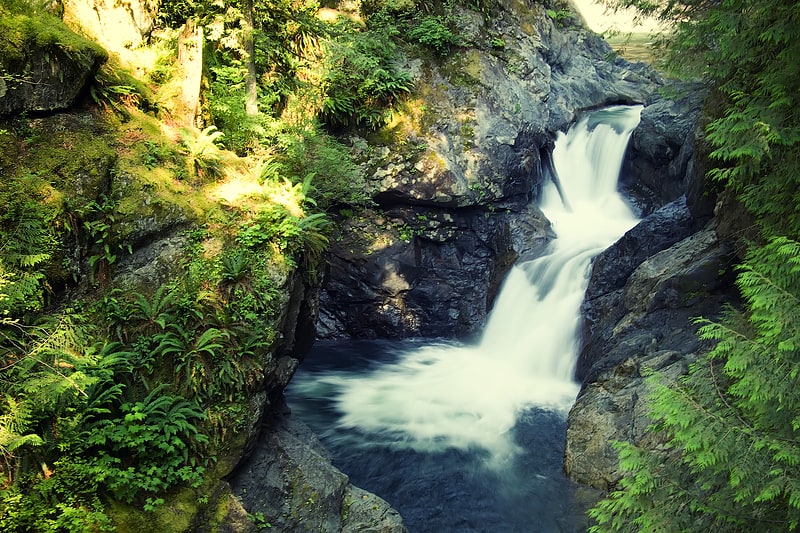
State park in King County, Washington. Olallie State Park is a public recreation area featuring multiple waterfalls located five miles southeast of North Bend, Washington. The state park spans a 3.5-mile stretch along the South Fork of the Snoqualmie River. The most prominent feature of the park is 135-foot-high Twin Falls.[7]
Address: 46910 SE Middle Fork Rd, Mount Baker–Snoqualmie National Forest
Mount Index
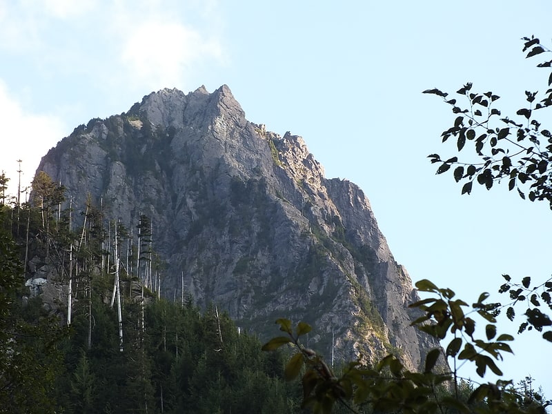
Peak in Washington State. Mount Index is a peak in the central part of the Cascade Range of Washington state. It lies just south of the Skykomish River and U.S. Route 2, at the western edge of the Cascades. Despite its low elevation relative to peaks higher in the Cascades, it is a famous and dramatic landmark due to its topographic prominence. It comprises three pointed spires which rise steeply from a very low base. The main peak is the southernmost of the three, while the North Peak rises even more steeply above the valley. For example, it rises more than 4,250 ft above the lower slopes on the northeast side in less than 1 horizontal mile.
The first recorded ascent of Mount Index (the main peak) was on October 29, 1911 by H. B. Hinman, Ernest Martin, Lee Pickett, George E. Wright. However, they found a flagpole already on the summit, so theirs was certainly not the first ascent. Since the easiest route is non-technical, a much earlier ascent by Native Americans is likely. The first ascent of the steeper, more difficult North Peak was in 1929, by Lionel Chute and Victor Kaartinen, by the North Face Route.
The standard route on the main peak climbs the east side of the peak from Lake Serene. The standard route on the North Peak is the North Face Route, which is a long, moderately technical climb (Grade III, Class 5.6).
Mount Index was once known as West Index Mountain, and Baring Mountain was known as Mount Index instead. They were both renamed in 1917.[8]
Big Four Mountain
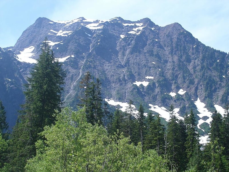
Mountain in Washington State. Big Four is a 6,160+ feet mountain summit in the Cascade Range, located about 20 miles east of Granite Falls, Washington. It is situated 4 miles west of Barlow Pass along the Mountain Loop Highway, near the Monte Cristo area, on land administered by the Mount Baker-Snoqualmie National Forest. Debris piles on the mountain's northern flank form as a result of avalanche activity. These fields of disturbed snow are able to remain year round in the shadow of the mountain. During the summer months snow-melt streams flow beneath the debris piles and cause caves to form in the ice. The caves vary in size from season to season and are unpredictably dangerous. The mountain is open to the public and a large snowfield can be reached by a short trail, but the snowfield itself is off-limits due to cave-ins and slides which have killed hikers in incidents in 1998, 2010, and 2015.[9]
Mount Washington
Mountain in Washington State. Mount Washington is a small mountain in the US state of Washington roughly 30 miles east-southeast of Seattle, Washington along Interstate 90. It lies on the western margin of the Cascade Range just above the coastal plains around Puget Sound, and is southeast of nearby town of North Bend.
Once known as Profile Mountain, Mount Washington was named due to a cliff resembling a profile of George Washington when viewed from an angle.
The hike to the top of Mt. Washington is known for its view. Cedar Butte lies at the west end of the mountain.[10]
Mount Dickerman
Mountain in Washington State. Mount Dickerman, or Dickerman Mountain, is a mountain in Mount Baker-Snoqualmie National Forest in Washington state. It is located northwest of Barlow Pass along the Mountain Loop Highway. A strenuous four mile trail leads from this highway to the summit with views which includes Glacier Peak, Monte Cristo Peak, and Sloan Peak.[11]