Discover 35 hidden attractions, cool sights, and unusual things to do in North Cascades National Park (United States). Don't miss out on these must-see attractions: Ruth Mountain, Hidden Lake Peaks, and Paul Bunyans Stump. Also, be sure to include Easy Peak in your itinerary.
Below, you can find the list of the most amazing places you should visit in North Cascades National Park (Washington).
Table of Contents
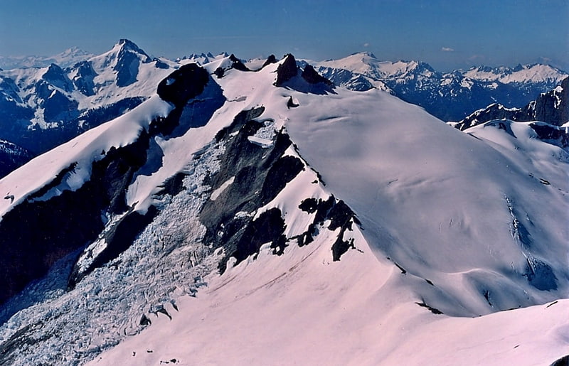
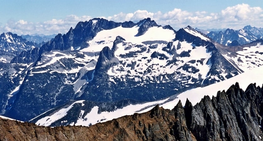
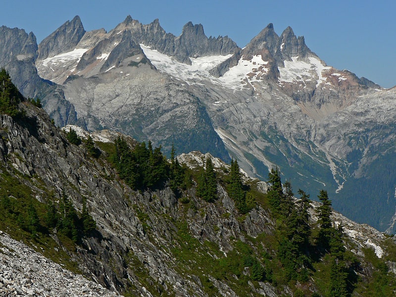
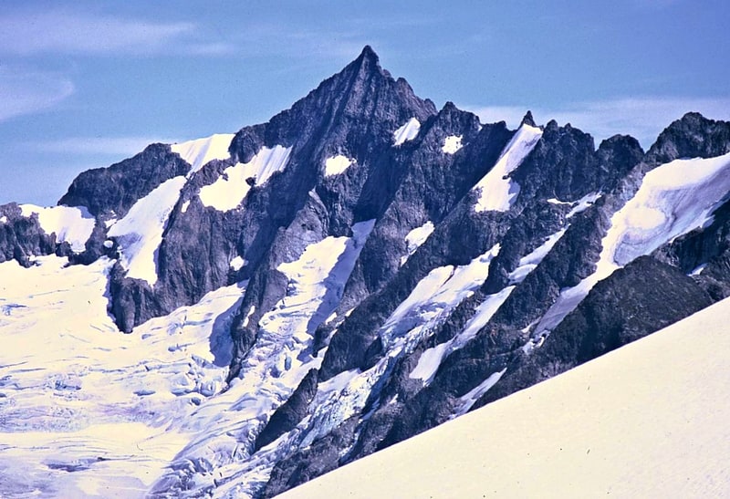
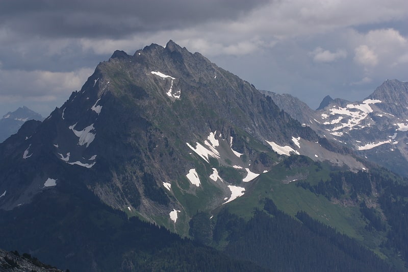
Ruth Mountain
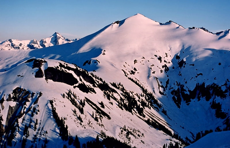
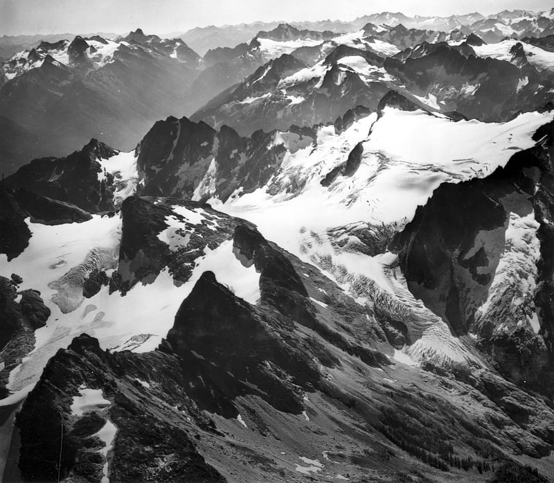
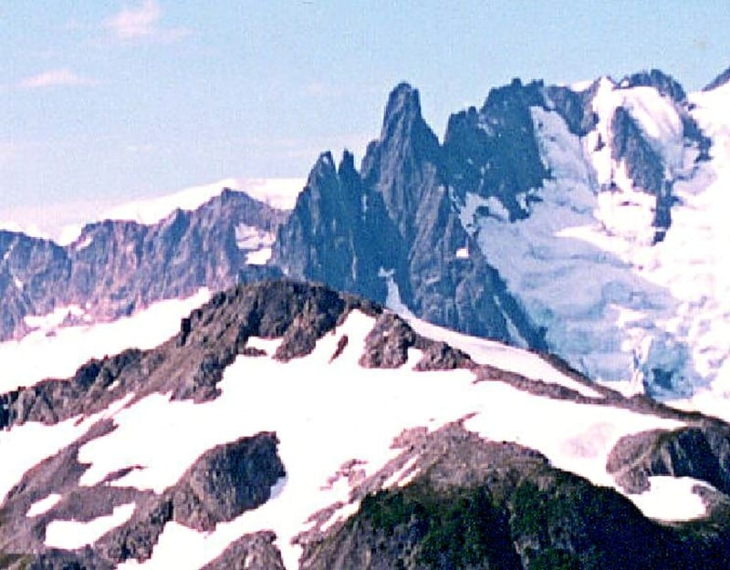
Summit in Washington State. Ruth Mountain is a 7,115 ft Skagit Range summit located two miles south of Hannegan Pass in the North Cascades of Washington state. The name honors Ruth Cleveland, daughter of President Grover Cleveland. This mountain's name was officially adopted in 1952 by the United States Board on Geographic Names. Ruth Mountain is situated on the shared border of North Cascades National Park and the Mount Baker Wilderness, which is part of the Mount Baker-Snoqualmie National Forest. The summit offers views of Mount Shuksan, East Nooksack Glacier, Seahpo Peak, Nooksack Tower, Icy Peak, Mount Sefrit, Mineral Mountain, and the Picket Range. The melting and receding Ruth Glacier on the north slope of Ruth creates the headwaters for the Chilliwack River. Precipitation runoff also finds its way into the Nooksack and Baker Rivers.[1]
Hidden Lake Peaks
Peak in Washington State. Hidden Lake Peaks is series of peaks with a maximum elevation of 7,088 feet that are located in the North Cascades, in Skagit County of Washington state. The peaks extend three miles southwest from the nearest higher peak called The Triad. Situated on the western boundary of North Cascades National Park, Hidden Lake Peaks are positioned west of the crest of the Cascade Range, approximately ten miles east of the town of Marblemount. The popular subsidiary peak, Hidden Lake Lookout, lies a half mile to the southwest of the highest summit. The mountain's name is taken from its proximity to Hidden Lake which lies in a cirque below the east aspect of these two main peaks. Precipitation runoff from Hidden Lake Peaks drains into Cascade River which is a tributary of the Skagit River.[2]
Paul Bunyans Stump
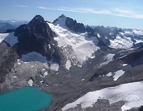
Mountain in Washington State. Paul Bunyans Stump is a 7,480+ ft mountain summit in the North Cascades Range of Washington, United States. It is located within North Cascades National Park. It rises steeply from Diablo Lake, one of the reservoirs on the Skagit River. It is part of a group of peaks that form the northern end of a chain running south through climbing destinations such as Colonial Peak and Snowfield Peak. The nearest peak to Paul Bunyans Stump is Pinnacle Peak, 0.37 mi to the north, and the nearest higher peak is Neve Peak, 0.9 mi to the southeast. Like many North Cascade peaks, Paul Bunyans Stump is more notable for its large, steep rise above local terrain than for its absolute elevation. Precipitation runoff from the mountain drains into Diablo Lake and Skagit River.
Paul Bunyans Stump was first climbed on August 2, 1931 by William Degenhardt and Herbert Strandberg of the Seattle Mountaineers. They called it "What's the Matterhorn." The approach is via the Pyramid Lake Trail, starting near Diablo Dam on the North Cascades Highway. From the lake, it's route-finding up Pyramid Arm and to Colonial Glacier. The standard route is a scramble on the southwest slope after accessing the Colonial Glacier.[3]
Easy Peak
Easy Peak is a 6,613-foot mountain summit in the Skagit Range of the North Cascades, in Whatcom County of Washington state. Easy Peak is situated in North Cascades National Park, and is often climbed during the Easy Ridge approach to Mount Challenger and the remote northern Pickets. Its nearest higher neighbor is Mineral Mountain, 2 mi to the west, and Whatcom Peak is set 2.1 mi to the east. Glacierets line the north slope of Easy Ridge between Easy Peak and Whatcom Peak. Precipitation runoff from this peak drains north into the Chilliwack River, or south into headwaters of the Baker River.[4]
Icy Peak
Mountain in Washington State. Icy Peak is a 7,073-foot Skagit Range mountain summit located in the North Cascades of Washington state. It is situated in North Cascades National Park at the head of Nooksack Cirque. High ridges connect it to Seahpo Peak and Mount Shuksan. An icefall occupies the northeast cirque, and small glaciers clad all sides of the peak. Precipitation runoff drains into the Nooksack and Baker Rivers.[5]
Buckner Mountain

Peak in Washington State. Buckner Mountain is a tall peak in the North Cascades of Washington state and in the Stephen Mather Wilderness of North Cascades National Park. At 9,114 feet in elevation it is the highest in Skagit County and one of about ten of Washington's non-volcanic peaks above 9,000 feet high. It is ranked as the 14th highest peak in the state, and the third highest peak in North Cascades National Park.[6]
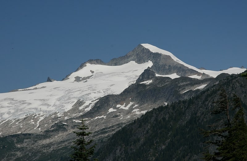
Mount Shuksan
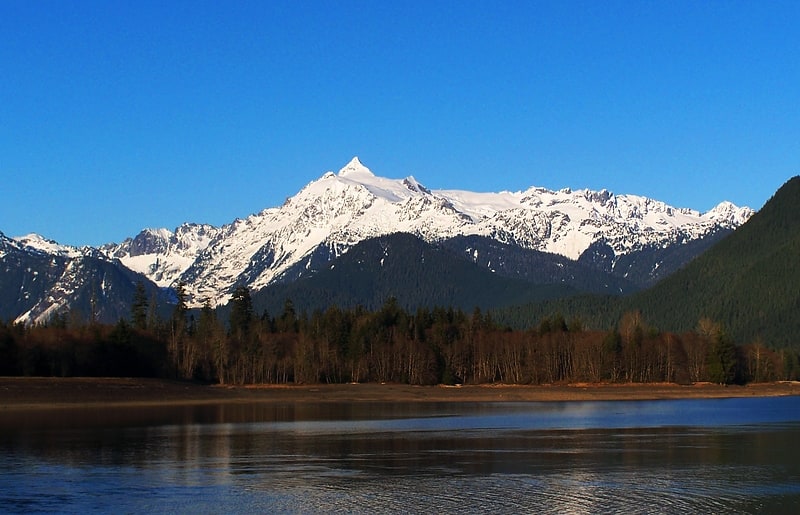
Notable peak for mountaineering and hiking. Mount Shuksan is a glaciated massif in the North Cascades National Park. Shuksan rises in Whatcom County, Washington immediately to the east of Mount Baker, and 11.6 miles south of the Canada–US border. The mountain's name Shuksan is derived from the Lummi word, said to mean "high peak". The highest point on the mountain is a three-sided peak known as Summit Pyramid.
The mountain is composed of Shuksan greenschist, oceanic basalt that was metamorphosed when the Easton terrane collided with the west coast of North America, approximately 120 million years ago. The mountain is an eroded remnant of a thrust plate formed by the Easton collision.
The Mount Baker Highway, State Route 542, is kept open during the winter to support Mt. Baker Ski Area. In late summer, the road to Artist Point allows visitors to travel a few miles higher for a closer view of the peak. Picture Lake is accessible on the highway and reflects the mountain, making it a popular site for photography.
Sulphide Creek Falls, one of the tallest waterfalls in North America, plunges off the southeastern flank of Mount Shuksan. There are four other tall waterfalls that spill off Mount Shuksan and neighboring Jagged Ridge and Seahpo Peak, mostly sourced from small snowfields and glaciers.
The traditional name of Mount Shuksan in the Nooksack language is Shéqsan ("high foot") or Ch’ésqen ("golden eagle"). Both the Nooksack and Lummi are indigenous tribes who have occupied the watersheds of the Nooksack Rivers and Lummi River, respectively. They are both federally recognized tribes in the United States.
The first ascent of Mount Shuksan is usually attributed to Asahel Curtis and W. Montelius Price on September 7, 1906. However, in a 1907 letter to the editor of the Mazamas club journal, C. E. Rusk attributed the first ascent to Joseph Morowits in 1897. He said that he himself would have attempted it in 1903 if he had not been sure that it had already been climbed.[7]
Mount Terror
Mountain in Washington State. Mount Terror is a mountain of the Cascade Range, located in the northwestern corner of Washington in Whatcom County. The peak is in North Cascades National Park, about 15.7 miles south of the Canada–United States border.[8]
Diobsud Buttes
Diobsud Buttes are summits near the western edge of the North Cascades, in Skagit County of Washington state. It's located north of Marblemount, Washington, and Helen Buttes, along the shared boundary of North Cascades National Park and the Noisy-Diobsud Wilderness. The nearest higher peak is Logger Butte, 0.85 mi to the north. Precipitation runoff from Diobsud Buttes drains into tributaries of the Skagit River.[9]
Mount Logan
Mount in Washington State. Mount Logan is located in North Cascades National Park in the U.S. state of Washington. Mount Logan is in a remote location of North Cascades National Park that requires hiking 20 mi from a trailhead to reach the peak. The mountain itself is not a difficult climb, though the easiest approaches require traversing glaciers and ropes are recommended. The peak supports three glaciers including Banded Glacier to the north, Fremont Glacier to the southwest and Douglas Glacier on the southeast slopes.[10]
Inspiration Peak
Inspiration Peak is a 7,880+ ft mountain summit located in the Picket Range within North Cascades National Park in the state of Washington. The peak lies 0.28 mi east of Mount Degenhardt, and 0.47 mi west of McMillan Spires. Terror Glacier remnants lie to the south of the peaks, and the McMillan Cirque glaciers hang on the north slopes. The first ascent of Inspiration Peak was made in 1940 by Fred Beckey and his brother Helmy via the West Ridge. Inspiration Peak can be seen from the North Cascades National Park Newhalem visitor center, weather permitting.[11]
Pierce Mountain
Pierce Mountain is a 4,973+ ft summit in the North Cascades Range of Washington, United States. It is located within North Cascades National Park and Stephen Mather Wilderness. It is situated above Ross Dam, at the eastern culmination of Sourdough Mountain. Like many North Cascade peaks, Pierce Mountain is more notable for its large, steep rise above local terrain than for its absolute elevation. Precipitation runoff from the mountain drains into the Skagit River via Pierce Creek and Ross Lake.[12]
Big Devil Peak
Big Devil Peak is a 7,055-foot-elevation mountain summit located in North Cascades National Park in Skagit County of Washington state. The peak lies midway between Marblemount and Newhalem and can be seen from the North Cascades Highway at the road pullout for Big Devil Falls. The peak rises 6,600+ feet above the valley floor at this viewing location in the valley. Big Devil is the highest peak of Teebone Ridge, and other peaks on this ridge include Little Devil Peak, Fallen Angel, and The Trapezoid. Precipitation runoff from the mountain drains into tributaries of the Skagit River.[13]
Goode Mountain
Peak in Washington State. Goode Mountain is one of the major peaks of the North Cascades in the U.S. state of Washington. Named for topographer Richard U. Goode of the USGS, it is the highest peak located in North Cascades National Park, between the Skagit River and Lake Chelan. It is the fourth-highest non-volcanic peak in Washington, and the twelfth-highest summit overall.
Goode Mountain is a massive mountain, rising over 6,000 feet (1,800 m) from its footings, and almost 7,000 feet (2,100 m) from the bottom of Bridge creek valley. The mountain is made up of one main peak, and two smaller sub-peaks, The West Tower, and southeast peak. Both are over 8,700 feet (2,700 m). On the northeast side it accomplishes this rise in only 1.6 horizontal miles (2.6 km). However, due to its isolated location in the rugged North Cascades, it is not visible from any major road. Goode Glacier is also located on the northeast slopes of the mountain, in addition to many small snowfields located at higher elevations. Other major features of the mountain are Greenview Lake elevation 5,455 feet (1,700 m), Memaloose Ridge over 7,200 feet (2,200 m), and Goode Ridge 7,640 feet (2,300 m).
The mountain was first climbed in 1936 via the Southwest Couloir/Southeast Ridge Route, which is still the least technical route. More popular now is the Northeast Buttress, pioneered by well-known climber Fred Beckey and Tom Stewart on August 6, 1966. It involves some snow, possible ice, and rock climbing up to class 5.5. One of the most impressive routes is The Megalodon Ridge first ascent was September 6, 2007 by Blake Herrington and Sol Wertkin. A IV+ 5.10 route, along a ridge over 5,000 feet (1,500 m) feet long, which took 12 hours to ascend by Blake Herrington and Sol Werkin. The route has 4,000 feet (1,200 m) to 5,000 feet (1,500 m) of exposure, it's considered one of the toughest established routes on the mountain.[14]
Mount Ross
Mountain in Washington State. Mount Ross is a 6,052-foot-elevation mountain summit located in the North Cascades, in Whatcom County, Washington, United States.[15]
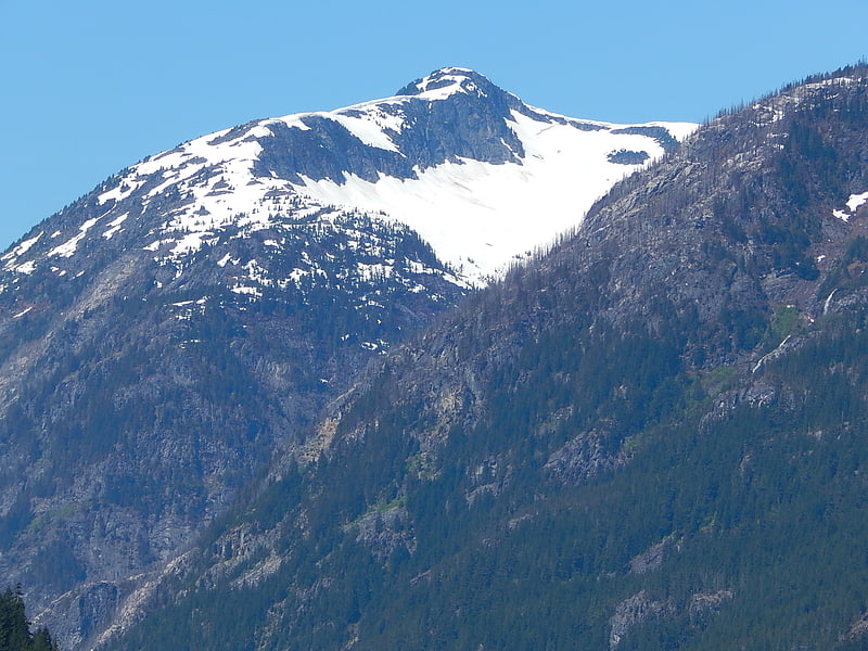
Mineral Mountain
Mineral Mountain is a 6,800-foot mountain summit in the Skagit Range of the North Cascades of Washington state. Mineral Mountain is situated in North Cascades National Park and the summit offers views of Mount Shuksan, Icy Peak, and the Picket Range. Easy Peak is set 2 mi to the east, and the nearest higher neighbor is Ruth Mountain, 3.06 mi to the west. Precipitation runoff from Mineral Mountain finds its way north into the Chilliwack River, and south into the Baker River.[16]
Eldorado Peak
Peak in Washington State. Eldorado Peak is a 8,868-foot peak, and is the 25th highest peak in Washington. The mountain is located in the North Cascades of Washington, approximately 27 miles east of Concrete. It is located in North Cascades National Park at the head of Marble Creek and just west of the Inspiration Glacier. Other glaciers in the immediate vicinity include Eldorado Glacier and McAllister Glacier; thus Eldorado is flanked by the largest continuous non-volcanic ice sheet in the lower 48 states.[17]
Mount Degenhardt
Mountain in Washington State. Mount Degenhardt, elevation 8,000+ ft, is a mountain peak in the Picket Range in the U.S. state of Washington and within North Cascades National Park. Located in the northern section of the park, Mount Degenhardt is.30 mi southeast of Mount Terror,.28 mi west of Inspiration Peak. and.75 mi west of McMillan Spire. Mount Degenhardt is named after William Degenhardt, an early 20th century mountain climber. The Terror Glacier lies on the southeast slopes of Mount Degenhardt.[18]
Indian Mountain
Indian Mountain is a remote 7,133-foot mountain summit in the Skagit Range of the North Cascades, in Whatcom County of Washington state. Indian Mountain is situated in North Cascades National Park, 7 miles south of the Canada–United States border. Its nearest higher neighbor is Red Face Mountain, 1.14 mi to the southeast, and Whatcom Peak rises 2.9 mi to the south. Although modest in elevation, relief is significant since this peak rises over 4,100 feet above Brush Creek Valley in approximately one mile. Precipitation runoff from Indian Mountain drains into tributaries of the Chilliwack River.[19]
Black Peak
Peak in Washington State. Black Peak is a tall peak in the Cascade Range in the U.S. state of Washington. It lies in the Stephen Mather Wilderness and North Cascades National Park. At 8,975 feet in elevation it is the 20th-highest peak in Washington. Black Peaks's prominence is 3,450 feet, making it the 35th-most prominent peak in Washington. The nearest higher peak is Goode Mountain, 5.2 miles to the west-southwest.
Black Peak is a non-volcanic mountain and is popular among hikers and campers worldwide.[20]
Sahale Mountain
Mountain in Washington State. Sahale Mountain is a jagged, glaciated mountain, in North Cascades National Park, in northern Washington state. The summit of Sahale Mountain is referred to as Sahale Peak. It is 0.3 miles south of its higher neighbor, Boston Peak, and the saddle between the two is 80 feet lower than Sahale's summit. Quien Sabe Glacier is to the west of the ridge between the two peaks while Davenport Glacier is in a cirque east of this ridge and above Horseshoe Basin. Sahale Glacier is south of the summit and east of Sahale Arm, a ridge that extends southwest from Sahale to Cascade Pass. The name Sahale may originate from a Northwest Native American word meaning "high place," "falcon," or "sacred."[21]
Forbidden Peak
Peak in Washington State. Forbidden Peak is an 8,815 feet glacial horn located in North Cascades National Park, in Skagit County of Washington state. It is part of the North Cascades and is located near Cascade Pass. Forbidden Peak features a rock climbing route named West Ridge route which is featured in Fifty Classic Climbs of North America. The peak was first climbed by a party consisting of Fred Beckey, his brother Helmy Beckey, Jim Crooks, Lloyd Anderson and Dave Lind in 1940.[22]
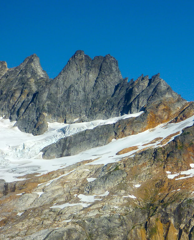
Colonial Peak
Mountain in Washington State. Colonial Peak is a mountain in the North Cascades of Washington, United States. It rises steeply from the southwest bank of Thunder Arm of Diablo Lake, one of the artificial reservoirs on the Skagit River. It is part of a group of peaks that form the northern end of a chain running south through prized climbing destinations such as Eldorado Peak, Forbidden Peak, and Goode Mountain. Colonial Peak takes its name from the Colonial mining claim on its slopes.
Like many North Cascade peaks, Colonial Peak is more notable for its large, steep rise above local terrain than for its absolute elevation. For example, it rises 6,560 feet (2,000 m) above Thunder Arm in only 2.3 horizontal miles (3.7 km). Its rise over the Skagit river on the northwest is even greater, but not as steep.
Colonial Peak was first climbed on July 31, 1931 by William Degenhardt and Herbert Strandberg of the Seattle Mountaineers. The standard route is the West Ridge, accessed from Colonial Glacier; the approach is via the Pyramid Lake Trail, starting from near Diablo Dam on the North Cascades Highway.[23]
Snowfield Peak
Peak in Washington State. Snowfield Peak is in North Cascades National Park in the U.S. state of Washington. Located in the south unit of the park, Snowfield Peak is.70 mi east of the summit known as Horsemans Pack and the Neve Glacier descends from the north slopes of the mountain.[24]
Stephen Mather Wilderness
National park in Whatcom County, Washington. The Stephen Mather Wilderness is a 634,614 acres wilderness area honoring Stephen Mather, the first director of the National Park Service. It is located within North Cascades National Park, Lake Chelan National Recreation Area, and Ross Lake National Recreation Area in the North Cascade Range of Washington, United States.
It is bordered by the Pasayten Wilderness to the northeast, the Mount Baker Wilderness to the northwest, the Noisy-Diobsud Wilderness to the west, the Glacier Peak Wilderness to the southwest, and the Lake Chelan-Sawtooth Wilderness to the southeast.
The North Cascades National Park Complex consists of three units which make up Stephen Mather Wilderness: 505,000-acre (204,366 ha) North Cascades National Park, which boasts 504,614 acres (204,210 ha) acres of designated wilderness; 117,600-acre (47,591 ha) Ross Lake National Recreation Area, a slim piece of land just east of the park that has 74,000 acres (29,947 ha) acres of designated wilderness; and 62,000-acre (25,091 ha) Lake Chelan National Recreation Area, at the southeast corner of the park, with 56,000 acres (22,662 ha) of designated wilderness.[25]
Johannesburg Mountain
Peak in Washington State. Johannesburg Mountain is one of the most famous peaks in the North Cascades of Washington state. Though not one of the top 100 peaks in the state by elevation, nor one of the top peaks as ranked by topographic prominence, Johannesburg is notable for its large, steep local relief, and particularly its immense, dramatic Northeast Face, which drops 5,000 feet in only 0.9 miles.
The name "Johannesburg Mountain" comes, through an error, from "Johnsberg," the name of three mining claims on the north face of the peak. It has also been called "Elsbeth."
Johannesburg Mountain was first climbed on July 26, 1938, by Calder Bressler, Bill Cox, Ray W. Clough, and Tom Myers, via a version of the most popular route today, the East Ridge/Cascade-Johannesburg Couloir Route. This route, and others which also finish on the south side of the mountain, are mostly scrambling routes. However, there are many routes on the north and northeast faces which are highly technical and involve considerable objective danger from falling rock and ice.[26]
The Chopping Block
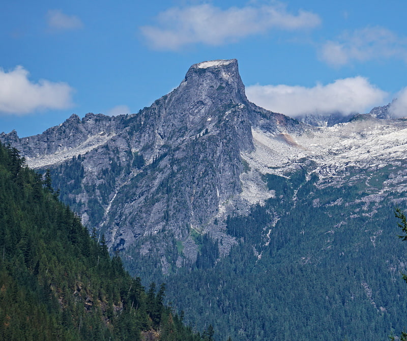
The Chopping Block is a 6,819-foot mountain summit located in the Picket Range within North Cascades National Park in the state of Washington. The mountain is officially named Pinnacle Peak on maps, but hardly anyone calls it by that name. The nearest higher peak is Mount Degenhardt, 0.6 mi to the northeast. The Chopping Block can be seen from the North Cascades National Park Newhalem visitor center, weather permitting. Precipitation runoff from the peak drains into Goodell Creek, a tributary of the Skagit River.[27]
Mount Challenger
Peak in Washington State. Mount Challenger is in North Cascades National Park in the U.S. state of Washington. A difficult peak to approach due to its isolation, one of the most common routes to the summit involves ascending the Challenger Glacier on the north slopes of the peak. Mount Challenger is one of the taller peaks of the Picket Range.[28]
Doubtful Lake
Lake in Washington State. Doubtful Lake is located in North Cascades National Park, in the U. S. state of Washington. Doubtful Lake can be accessed on foot by way of Cascade Pass and following the Sahale Arm Trail to another side trail which leads to the lake. A designated backcountry camping zone is located at the lake.[29]
Silver Lake
Lake in Washington State. Silver Lake is located in North Cascades National Park, in the U. S. state of Washington. Silver Lake is less than 1 mi north of Mount Spickard and is partially fed by melt from the Silver Glacier which is on the north slopes of Spickard. To the north and west of Silver Lake lies the arête known as Custer Ridge culminating in Mount Rahm. Silver Lake is only.50 mi south of the Canada–United States border.[30]
Dagger Lake
Lake in Washington State. Dagger Lake is located in North Cascades National Park, in the U. S. state of Washington. Dagger Lake is accessible via the Twisp Pass Trail and the lake is 7.6 mi from the North Cascades Highway or 4.7 mi from the Twisp River Road trailhead in Wenatchee National Forest.[31]
Davis Peak
Mountain in Washington State. Davis Peak is a mountain just north of Gorge Lake in North Cascades National Park, in the US state of Washington. It is located just south of the Picket Range. While not of particularly high elevation, even for the North Cascades, it is notable for its large, steep local relief, and in particular for its huge Northeast Face, which drops 5,250 ft in one horizontal mile. This is one of the two largest vertical drops in one horizontal mile in the contiguous United States, the other being the North Face of Kinnerly Peak.
Davis Peak had been known as Stetattle Peak until the Reaburn climbing party of 1904 renamed it in honor of the early homesteading family of Lucinda Davis. The Davis family had built and ran a roadhouse for trappers, miners and other travelers at the base of the peak, near present-day Diablo, prior to the arrival of roads or rail, circa 1900.[32]
Booker Mountain
Mountain in Washington State. Booker Mountain, also known as Mount Booker, with an elevation of 8,284 feet, is located in the North Cascades of Washington, about 1.5 miles SE of Mount Buckner, between Park Creek and Stehekin River.[33]
Nooksack Tower
Mount in Washington State. Nooksack Tower is in North Cascades National Park in the U.S. state of Washington. Nooksack Tower is part of the Mount Shuksan Massif and is.75 mi northeast of the main summit of Shuksan. Nooksack Tower looms to the west over Nooksack Cirque. The East Nooksack Glacier lies to the southeast, West Nooksack Glacier to the east and Price Glacier is on the north flanks of the tower. Nooksack Tower is one of the most difficult mountains to climb in the Cascade Range, with loose rock, 50-degree or greater slopes and ice ridges as well as accessibility issues and exposure, all weighing into the climbing equation. The descent may require ten or more rappels.[34]
Sourdough Mountain
Mountain in Washington State. Sourdough Mountain is in North Cascades National Park in the U.S. state of Washington. The Sourdough Mountain Lookout, is a fire lookout that was built by the Civilian Conservation Corps in 1933 near the summit. The lookout was placed on the National Register of Historic Places in 1989.[35]