Discover 4 hidden attractions, cool sights, and unusual things to do in Uncompahgre Wilderness (United States). Don't miss out on these must-see attractions: Uncompahgre Peak, Wetterhorn Peak, and San Juan Mountains. Also, be sure to include Matterhorn Peak in your itinerary.
Below, you can find the list of the most amazing places you should visit in Uncompahgre Wilderness (Colorado).
Table of Contents
Uncompahgre Peak
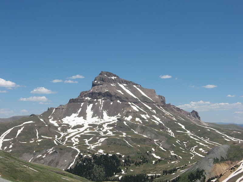
Summit in Colorado. Uncompahgre Peak is the sixth highest summit of the Rocky Mountains of North America and the U.S. state of Colorado. The prominent 14,321-foot fourteener is the highest summit of the San Juan Mountains and the highest point in the drainage basin of the Colorado River and the Gulf of California. It is located in the Uncompahgre Wilderness in the northern San Juans, in northern Hinsdale County approximately 7 miles west of the town of Lake City.
Uncompahgre Peak has a broad summit plateau, rising about 1,500 ft (500 m) above the broad surrounding alpine basins. The south, east and west sides are not particularly steep, but the north face has a 700 ft (210 m) cliff. Like all peaks in the San Juan Mountains, Uncompahgre is of volcanic origin, but is not a volcano. The rock is of poor quality for climbing, precluding an ascent of the north face.
The most popular route for climbing Uncompahgre Peak is Uncompahgre National Forest Service Trail Number 239, which starts from the end of the Nellie Creek Road, east-southeast of the peak. The Nellie Creek Road is a four wheel drive road accessed from the Henson Creek Road, about 4 miles (6.4 km) west of Lake City. The trail to the summit is a strenuous hike rising 2,919 ft (890 m) in elevation in about 3.5 mi (6 km). It accesses the summit in a winding ascent, starting from the east, passing over a south-trending ridge, and finishing on the west slopes of the summit plateau.
The peak's name comes from the Ute word Uncompaghre, which loosely translates to "dirty water" or "red water spring" and is likely a reference to the many hot springs in the vicinity of Ouray, Colorado.[1]
Wetterhorn Peak
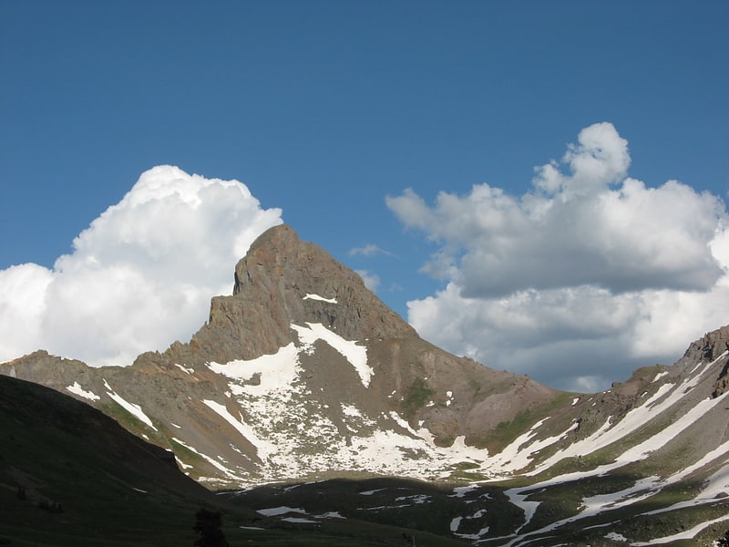
Mountain in Colorado. Wetterhorn Peak is a fourteen thousand foot mountain peak in the U.S. state of Colorado. It is located in the Uncompahgre Wilderness of the northern San Juan Mountains, in northwestern Hinsdale County and southeastern Ouray County, 9 miles east of the town of Ouray. It lies 2.75 mi west of Uncompahgre Peak.
Wetterhorn Peak, and its neighbor Matterhorn Peak, 13,590 ft (4,142 m), are named after the Wetterhorn and the Matterhorn, two famous peaks in the Swiss Alps. Both Colorado peaks are pointed rock spires (hence resembling their namesake peaks), whose shapes contrast with the broad bulk of the higher Uncompahgre Peak.
The first recorded ascent of the peak was made in 1906 by George Barnard, C. Smedley, W. P. Smedley, and D. Utter, but a previous ascent by miners working in the area in the 19th century is likely.
The standard, and only common, route on Wetterhorn Peak is the southeast ridge, which is accessed via the Matterhorn Creek drainage on the south side of the mountain. The trailhead is on the Henson Creek Road, accessible from Lake City. The route involves 3,535 ft (1,077 m) of ascent from the trailhead and some exposed scrambling (Class 3/4) on the ridge itself. The nearby east face is considered a high-quality advanced snow climb or extreme ski descent.[2]
San Juan Mountains
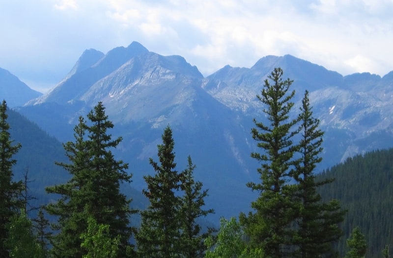
Mountain range in Colorado. The San Juan Mountains is a high and rugged mountain range in the Rocky Mountains in southwestern Colorado and northwestern New Mexico. The area is highly mineralized and figured in the gold and silver mining industry of early Colorado. Major towns, all old mining camps, include Creede, Lake City, Silverton, Ouray, and Telluride. Large scale mining has ended in the region, although independent prospectors still work claims throughout the range. The last large scale mines were the Sunnyside Mine near Silverton, which operated until late in the 20th century and the Idarado Mine on Red Mountain Pass that closed down in the 1970s. Famous old San Juan mines include the Camp Bird and Smuggler Union mines, both located between Telluride and Ouray.
The Summitville mine was the scene of a major environmental disaster in the 1990s when the liner of a cyanide-laced tailing pond began leaking heavily. Summitville is in the Summitville caldera, one of many extinct volcanoes making up the San Juan volcanic field. One, La Garita Caldera, is 35 miles (56 km) in diameter. Large beds of lava, some extending under the floor of the San Luis Valley, are characteristic of the eastern slope of the San Juans.
Tourism is now a major part of the regional economy, with the narrow gauge railway between Durango and Silverton being an attraction in the summer. Jeeping is popular on the old trails which linked the historic mining camps, including the notorious Black Bear Road. Visiting old ghost towns is popular, as is wilderness trekking and mountain climbing. Many of the old mining camps are now popular sites of summer homes. Though the San Juans are extremely steep and receive much snow, so far only Telluride has made the transition to a major ski resort. Purgatory Resort, once known as Durango Mountain Resort, is a small ski area 26 miles north of Durango. There is also skiing on Wolf Creek Pass at the Wolf Creek ski area. Recently Silverton Mountain ski area has begun operation near Silverton.
The Rio Grande drains the east side of the range. The other side of the San Juans, the western slope of the continental divide, is drained by tributaries of the San Juan, Dolores and Gunnison rivers, which all flow into the Colorado River.
The San Juan and Uncompahgre National Forests cover a large portion of the San Juan Mountains. The Continental Divide Trail, a long-distance hiking trail follows the crest of the San Juan Mountains. The Weminuche Wilderness, Colorado's largest wilderness area, with an area of 499,771 acres (202,250 ha) is in the San Juans.
The San Juan Mountains are also distinctive for their high altitude plateaus and peaks. As a result, facilities in the towns and cities of the region are among the highest in the nation. Telluride Airport, at an elevation of 9,070 feet, is the highest in the United States with regularly scheduled commercial service.[3]
Matterhorn Peak
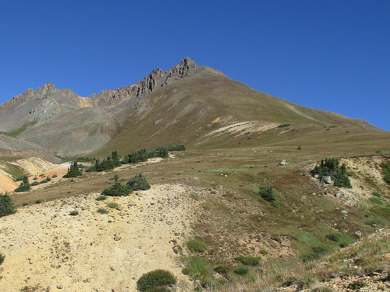
Mountain in Colorado. Matterhorn Peak is a high mountain summit in the San Juan Mountains range of the Rocky Mountains of North America. The 13,596-foot thirteener is located in the Uncompahgre Wilderness of Uncompahgre National Forest, 10.3 miles west by north of the Town of Lake City in Hinsdale County, Colorado, United States.[4]