Discover 9 hidden attractions, cool sights, and unusual things to do in Mount Baker (United States). Don't miss out on these must-see attractions: Boulder Glacier, Coleman Glacier, and Roosevelt Glacier. Also, be sure to include Lincoln Peak in your itinerary.
Below, you can find the list of the most amazing places you should visit in Mount Baker (Washington).
Table of Contents
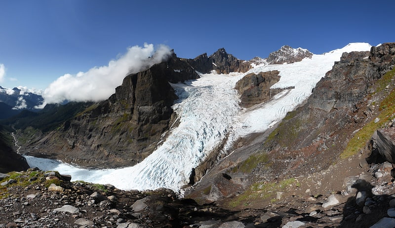
Boulder Glacier
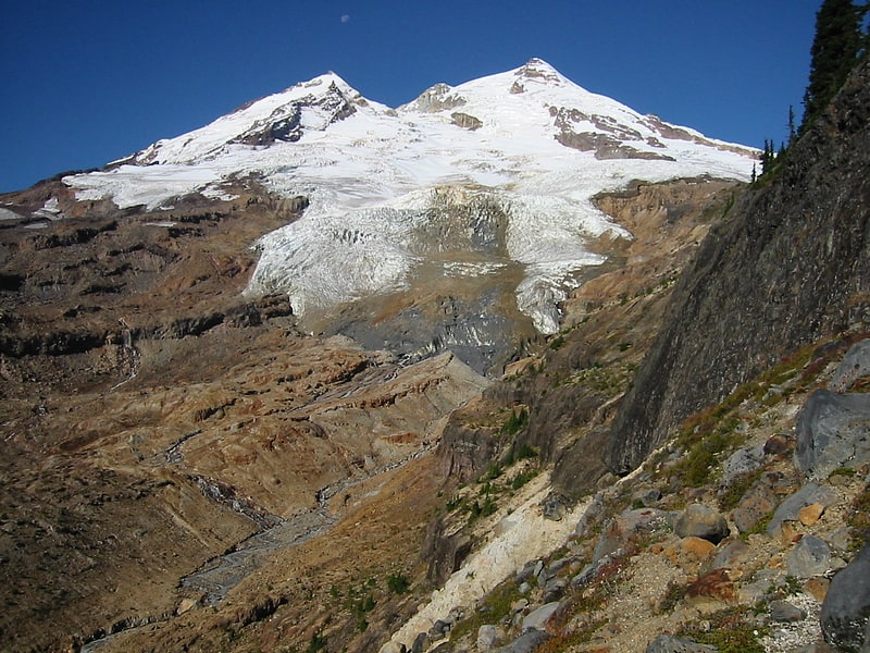
Glacier in Washington State. Boulder Glacier is located on the southeast slope of Mount Baker, a stratovolcano near the Pacific coast of North America in the Cascade Range of Washington. Boulder Glacier is the sixth largest on Mount Baker with an area of 1.3 square miles. It flows from the summit crater between Grant Peak and Sherman Peak to about 5,000 ft. It is noteworthy for retreating 1,610 ft between 1987 and 2008, leaving newly exposed rock and soil behind.
Between 1850 and 1950, the glacier retreated 8,700 ft (2,700 m). William Long of the United States Forest Service observed the glacier beginning to advance due to cooler and wetter weather in 1953. This was followed by a 2,438-foot (743 m) advance by 1979. The 1979 terminus position is where the small stream enters Boulder Creek from the southwest. Observations in 2005 suggest that the lowest thousand feet or several hundred meters of the glacier is stagnant and will likely disappear. In the pictures, this section of the glacier is gray with rock debris and has few crevasses. On the west side of Boulder Creek is a small waterfall revealed by the recent recession of the glacier.
Boulder Glacier may be approached via the Boulder Ridge Trail number 605. The trail passes through a climax community of pacific silver fir and related species of disparate ages with many standing snags. In the fall, a large variety of mushroom species emerge. Near 4,300 ft (1,300 m) elevation, the trail ascends a lateral glacial moraine. At 4,600 ft (1,400 m) the route ascends about 20 ft (6.1 m) of Class 2 rock and 120 ft (37 m) of steep subalpine forest to reach the ridge crest. Soon thereafter, the trail disappears.
Boulder Ridge consists of scenic heather-covered benches and a number of lateral moraines left by vanished glaciers. Glacial retreat has left the upper portion of the ridge barren and unstable and rockfall from the terminus of that portion of the glacier is a hazard to the unwary visitor.
Boulder Glacier is one of the more popular climbing routes on Mount Baker. First climbed on August 24, 1891, it is most often ascended in combination with the cleaver between Boulder and Park Glacier to the north to bypass densely crevassed sections of the glacier. At about 10,000 ft (3,000 m) elevation, the route passes to the southwest of steep rock and ice to reach the summit ridge east of Grant Peak.[1]
Coleman Glacier
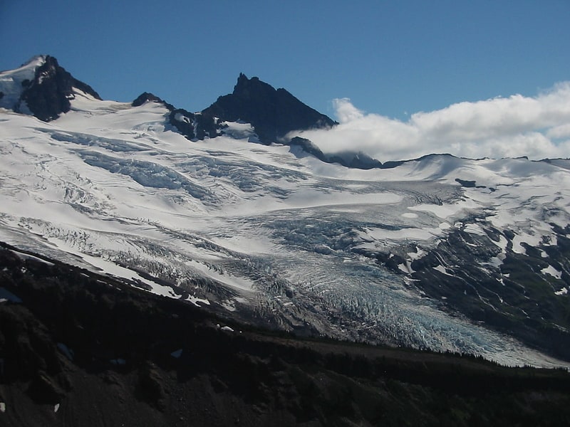
Glacier in Washington State. Coleman Glacier is located on Mount Baker in the North Cascades of the U.S. state of Washington. Between 1850 and 1950, Coleman Glacier retreated 8,200 ft. During a cooler and wetter period from 1950 to 1979, the glacier advanced 2,480 ft but between 1980 and 2006 retreated back 1,443 ft. Situated on the west slopes of Mount Baker, Coleman Glacier is bordered by the Roosevelt Glacier to the north and the Heliotrope Ridge to the south.[2]
Roosevelt Glacier
Glacier in Washington State. Roosevelt Glacier is located on the north slopes of Mount Baker in the North Cascades of the U.S. state of Washington. Roosevelt Glacier descends to nearly 5,000 ft at Chromatic Moraine. In the middle of its course, Roosevelt Glacier is connected to Coleman Glacier to its south.[3]
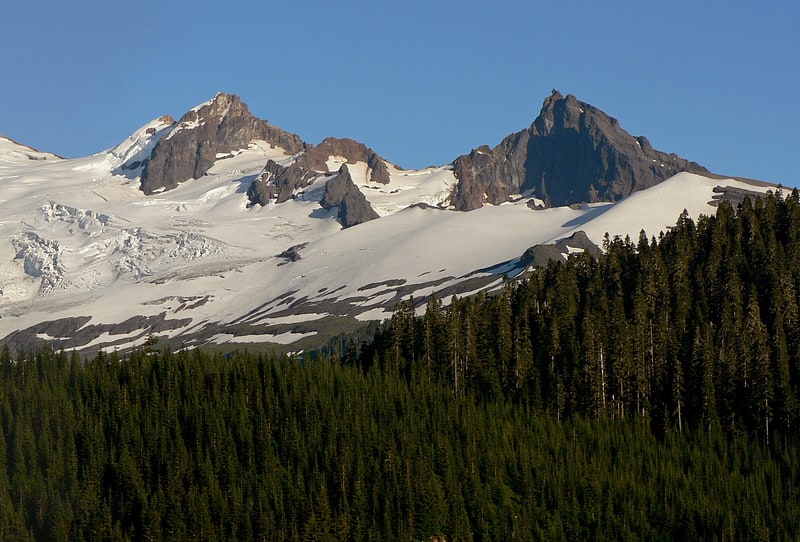
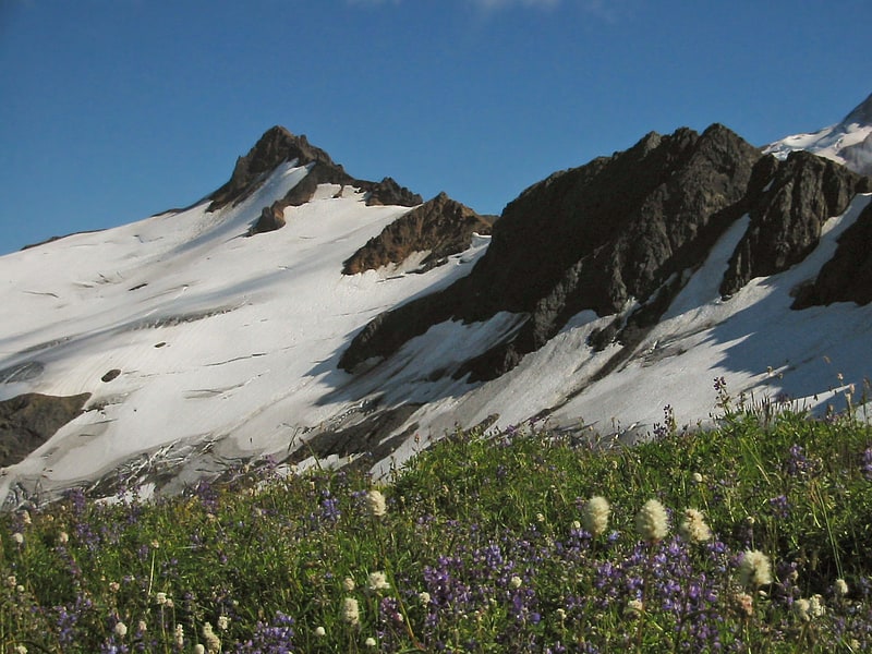
Lincoln Peak
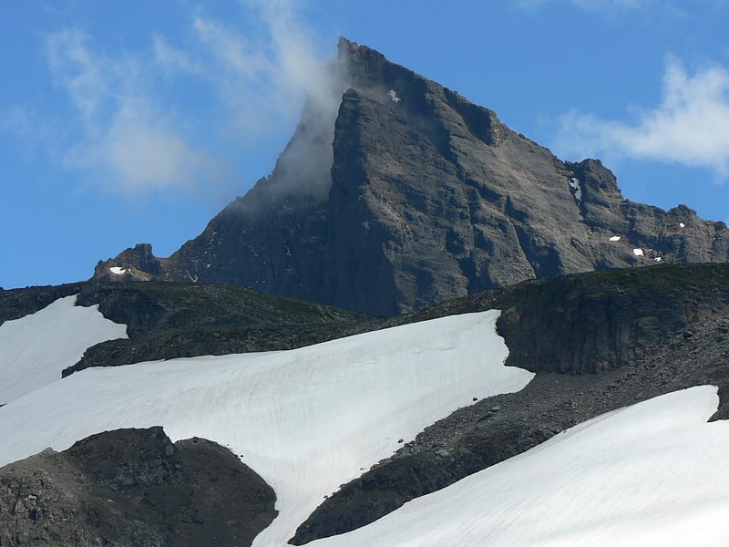
Peak in Washington. Lincoln Peak is a tall peak subsidiary to Mount Baker in the Cascade Range in the U.S. state of Washington. It lies within the Mount Baker Wilderness and Mount Baker-Snoqualmie National Forest. At over 9,080 feet in elevation it is the 16th-highest peak in Washington and 31st-highest in the Cascades, however Lincoln Peak's prominence is only 720 feet. The nearest higher peak is Colfax Peak, 0.6 miles to the east-northeast. Lincoln, Colfax, and Seward Peaks are erosional remnants from a much older eruptive episode, with more recent volcanic activity resulting in the nearby cone of the Mount Baker volcano.[4]
Black Buttes
Volcano in Washington State. The Black Buttes, also known historically as the Sawtooth Rocks, make up an extinct stratovolcano in the Cascade Volcanic Arc in Whatcom County, Washington, United States. Glacially eroded remnants of this volcano rise above the Deming Glacier, part of the glacier system of the nearby volcano, Mount Baker. There are three major peaks — Colfax, Lincoln, and Seward — all of which can be climbed.
The volcano was last active during the mid-Pleistocene from 495,000 to 288,000 years ago. Mount Baker, a much younger volcano, sits on top of lava erupted from Black Buttes Volcano.[5]
Deming Glacier
Deming Glacier is located on Mount Baker in the North Cascades of the U.S. state of Washington. Between 1850 and 1950, Deming Glacier retreated 7,217 ft. During a cooler and wetter period from 1950 to 1979, the glacier advanced 2,060 ft but between 1980 and 2006 retreated back 1,140 ft. Situated on the southwest slopes of Mount Baker, Deming Glacier is bordered by the Easton Glacier to the east and the Black Buttes ridge to the west.[6]
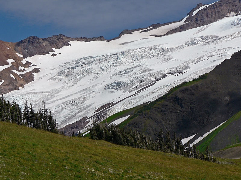
Park Glacier
Glacier in Washington State. Park Glacier is located on the northeast slopes of Mount Baker in the North Cascades of the U.S. state of Washington. Park Glacier descends to the Park Cliffs along its eastern margin while the northern tongue of the glacier descends to nearly 4,500 ft and is below Park Cliffs and Lava Divide. In the middle of its course, Park Glacier is connected to Rainbow Glacier to the north and Boulder Glacier to the south.[7]
Hadley Glacier
Hadley Glacier is located on Mount Baker in the North Cascades of the U.S. state of Washington. Situated on the north slopes of Mount Baker, Hadley Glacier is north of Hadley Peak on a spur from Mount Baker.[8]
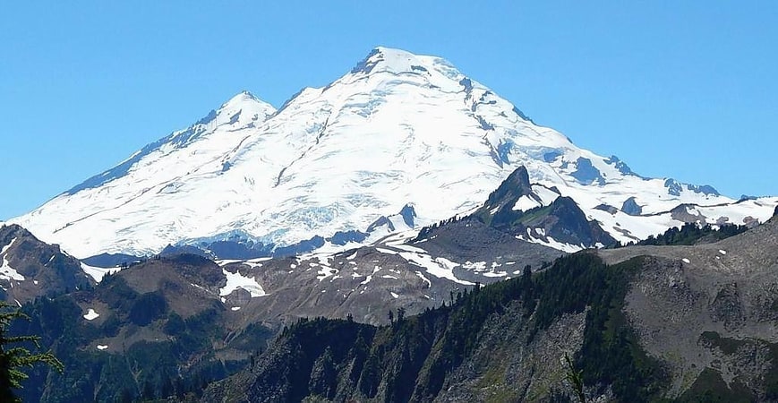
Mount Baker
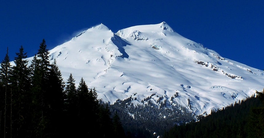
Notable peak with a variety of trails. Mount Baker, also known as Koma Kulshan or simply Kulshan, is a 10,781 ft active glacier-covered andesitic stratovolcano in the Cascade Volcanic Arc and the North Cascades of Washington in the United States. Mount Baker has the second-most thermally active crater in the Cascade Range after Mount St. Helens. About 30 miles due east of the city of Bellingham, Whatcom County, Mount Baker is the youngest volcano in the Mount Baker volcanic field. While volcanism has persisted here for some 1.5 million years, the current volcanic cone is likely no more than 140,000 years old, and possibly no older than 80–90,000 years. Older volcanic edifices have mostly eroded away due to glaciation.
After Mount Rainier, Mount Baker has the heaviest glacier cover of the Cascade Range volcanoes; the volume of snow and ice on Mount Baker, 0.43 cu mi (1.79 km3) is greater than that of all the other Cascades volcanoes (except Rainier) combined. It is also one of the snowiest places in the world; in 1999, Mount Baker Ski Area, located 9 mi (14.5 km) to the northeast, set the world record for recorded snowfall in a single season—1,140 in (29 m; 95 ft).
Mount Baker is the third-highest mountain in Washington and the fifth-highest in the Cascade Range, if Little Tahoma Peak, a subpeak of Mount Rainier, and Shastina, a subpeak of Mount Shasta, are not counted. Located in the Mount Baker Wilderness, it is visible from much of Greater Victoria, Nanaimo, and Greater Vancouver in British Columbia, and to the south, from Seattle (and on clear days Tacoma) in Washington.
Indigenous peoples have known the mountain for thousands of years, but the first written record of the mountain is from Spanish explorer Gonzalo Lopez de Haro, who mapped it in 1790 as Gran Montaña del Carmelo, "Great Mount Carmel". The explorer George Vancouver renamed the mountain for 3rd Lieutenant Joseph Baker of HMS Discovery, who saw it on April 30, 1792.[9]