Discover 6 hidden attractions, cool sights, and unusual things to do in Ngorongoro Conservation Area (Tanzania). Don't miss out on these must-see attractions: Olduvai Gorge, Laetoli, and Lake Eyasi. Also, be sure to include Crater Highlands in your itinerary.
Below, you can find the list of the most amazing places you should visit in Ngorongoro Conservation Area (Arusha).
Table of Contents
Olduvai Gorge
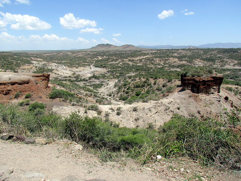
Site known for early human remains. The Olduvai Gorge or Oldupai Gorge in Tanzania is one of the most important paleoanthropological localities in the world; the many sites exposed by the gorge have proven invaluable in furthering understanding of early human evolution. A steep-sided ravine in the Great Rift Valley that stretches across East Africa, it is about 48 km long, and is located in the eastern Serengeti Plains within the Ngorongoro Conservation Area in the Olbalbal ward located in Ngorongoro District of Arusha Region, about 45 kilometres from Laetoli, another important archaeological locality of early human occupation. The British/Kenyan paleoanthropologist-archeologist team of Mary and Louis Leakey established excavation and research programs at Olduvai Gorge that achieved great advances in human knowledge and are world-renowned.
The gorge takes its name from the Maasai word oldupai which means "the place of the wild sisal" as the East African wild sisal (Sansevieria ehrenbergii) grows abundantly throughout the gorge area. Twenty-five kilometers downstream of Lake Ndutu and Lake Masek, the gorge cuts into Pleistocene lake bed sediments up to a depth of 90 m. A side gorge, originating from Lemagrut Mountain, joins the main gorge 8 km from the mouth. This side gorge follows the shoreline of a prehistoric lake, rich in fossils and early hominin sites. Periodic flows of volcanic ash from Olmoti and Kerimasi helped to ensure preservation of the fossils in the gorge.
The locality is significant in showing the increasing developmental and social complexities in the earliest humans, or hominins, largely revealed in the production and use of stone tools. Prior to tools, evidence of scavenging and hunting can be noted—highlighted by the presence of gnaw marks that predate cut marks—and of the ratio of meat versus plant material in the early hominin diet. The collecting of tools and animal remains in a centralised area is evidence of developing social interaction and communal activity. All these factors indicate an increase in cognitive capacities at the beginning of the period of hominids transitioning to hominin—that is, to human—form and behaviour.
Homo habilis, probably the first early human species, occupied Olduvai Gorge approximately 1.9 million years ago (mya); then came a contemporary australopithecine, Paranthropus boisei, 1.8 mya, followed by Homo erectus, 1.2 mya. Our species Homo sapiens, which is estimated to have emerged roughly 300,000 years ago, is thought to have occupied sites in the gorge by 17,000 years ago.[1]
Laetoli
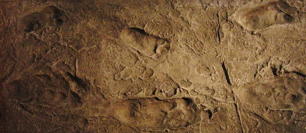
Laetoli is a pre-historic site in located in Enduleni ward of Ngorongoro District in Arusha Region, Tanzania. The site is dated to the Plio-Pleistocene and famous for its hominin footprints, preserved in volcanic ash. The site of the Laetoli footprints is located 45 km south of Olduvai gorge. The location and tracks were discovered by archaeologist Mary Leakey and her team in 1976, and were excavated by 1978. Based on analysis of the footfall impressions "The Laetoli Footprints" provided convincing evidence for the theory of bipedalism in Pliocene hominins and received significant recognition by scientists and the public. Since 1998, paleontological expeditions have continued under the leadership of Amandus Kwekason of the National Museum of Tanzania and Terry Harrison of New York University, leading to the recovery of more than a dozen new hominin finds, as well as a comprehensive reconstruction of the paleoecology.
Dated to 3.7 million years ago, they were the oldest known evidence of hominin bipedalism at that time. Subsequently, older Ardipithecus ramidus fossils were found with features that suggest bipedalism. With the footprints there were other discoveries excavated at Laetoli including hominin and animal skeletal remains. Analysis of the footprints and skeletal structure showed clear evidence that bipedalism preceded enlarged brains in hominins. At a species level, the identity of the hominins who made the trace is difficult to construe precisely; Australopithecus afarensis is the species most commonly proposed.[2]
Lake Eyasi
Also known as: Ziwa Eyasi
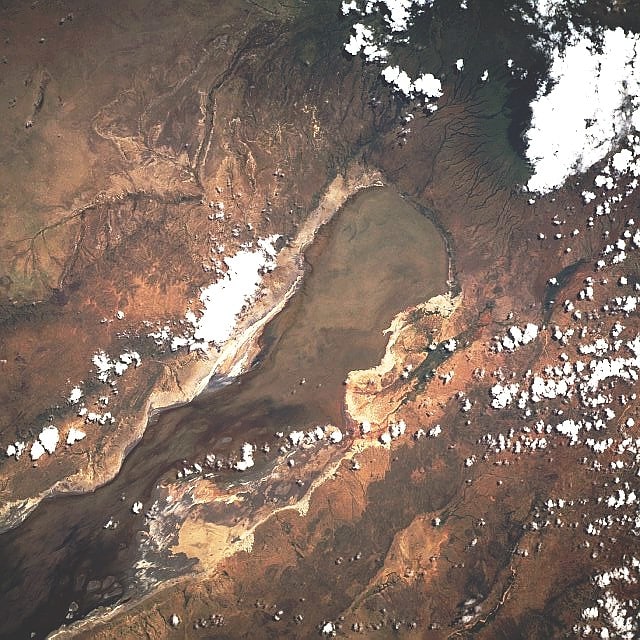
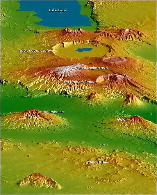
Lake in Tanzania. Lake Eyasi is a lake located in Karatu District of Arusha Region in north Tanzania. Lake Eyasi is the largest body of water in Arusha region. It is a seasonal shallow endorheic salt lake on the floor of the Great Rift Valley at the base of the Serengeti Plateau, just south of the Serengeti National Park and immediately southwest of the Ngorongoro Crater in the Crater Highlands of Tanzania. The lake is elongated, orientated southwest to northeast, and lies in the Eyasi-Wembere branch of the Great Rift Valley.
The principal inflow is the Sibiti River, which enters the southwestern end. The river may continue to flow somewhat year round, at least in wetter years; the other inflows are all seasonal. The second largest inflow is the Baray, at the northeast. The water carried by the Baray has increased in recent years due to deforestation of the Crater Highlands. The southwest flank of Mount Oldeani, one of the Ngorongoro volcanos, drains directly into the northeast end of the lake. Flow from the Budahaya / Udahaya River, which drains into the Yaeda Swamp to the southeast of the lake, was once second, but has decreased due to water diversion in the Mbulu Highlands. Water flow from the Serengeti is minor; the largest stream is the Sayu.
Seasonal water level fluctuations in the lake are dramatic, though the northwestern shore is constrained by the cliffs of the Serengeti Plateau. During the dry season the lake may dry up almost entirely, especially in drier years, so that Datooga herders and Hadza foragers will cross the lake on foot, but in El Niño years it may flood its banks and attract hippopotamus from the Serengeti. It is a seasonal stop for migrating flamingos. The lake supports minor local fishing in wet years, but more often catfish and lungfish are taken from the streams and springs that feed the lake. Even during wet periods, lake depths typically remain less than one metre.
The Hadza are the indigenous inhabitants of the lake. They are found along most of the perimeter, though camps are few along most of the Serengeti, which is Maasai territory. The Datooga inhabit the Yaeda Valley to the southeast, the Isanzu the south, and the Sukuma across the Sibiti River in the southwest. The Iraqw traditionally lived on the other side of Yaeda, but have come in increasing numbers to the Baray, which is now the primary onion-growing region of East Africa.
Mumba Cave is an archaeological site that is located by the shores of Lake Eyasi. The site has yielded a number of Middle Stone Age and Late Stone Age artifacts.[3]
Crater Highlands

The Crater Highlands are a geological region along the East African Rift in the Arusha Region and parts of northern Manyara Region in north Tanzania.[4]
Mount Loolmalasin
Also known as: Loolmalasin
Mountain in Tanzania. Mount Loolmalasin is a mountain located in the Ngorongoro District of the Arusha Region, Tanzania. It has a peak elevation of 3,682 metres above sea level. It is, after Mount Kilimanjaro and Mount Meru, the third-highest mountain in Tanzania if Kilimanjaro's three peaks are considered to be one mountain. Mount Loolmalasin is the second tallest mountain in Arusha Region and the tallest point in Ngorongoro District. The mountain also is the source of Simiyu River, which flows west to Lake Victoria in Simiyu Region.[5]
East African Rift
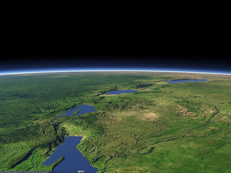
The East African Rift or East African Rift System is an active continental rift zone in East Africa. The EAR began developing around the onset of the Miocene, 22–25 million years ago. In the past it was considered to be part of a larger Great Rift Valley that extended north to Asia Minor.
A narrow zone, the rift is a developing divergent tectonic plate boundary where the African Plate is in the process of splitting into two tectonic plates, called the Somali Plate and the Nubian Plate, at a rate of 6–7 mm (0.24–0.28 in) per year. The rift system consists of three microplates, the Victoria Microplate to the north, and the Rovuma and Lwandle microplates to the south. The Victoria Microplate is rotating counter-clockwise with respect to the African plate. Its rotation is caused by the configuration of mechanically weaker and stronger lithospheric regions in the EARS.
As extension continues, lithospheric rupture will occur within 10 million years; the Somali Plate will break off and a new ocean basin will form.[6]