Discover 6 hidden attractions, cool sights, and unusual things to do in Mount St. Helens (United States). Don't miss out on these must-see attractions: Ape Cave, Ape Canyon, and Crater Glacier. Also, be sure to include Spirit Lake in your itinerary.
Below, you can find the list of the most amazing places you should visit in Mount St. Helens (Washington).
Table of Contents
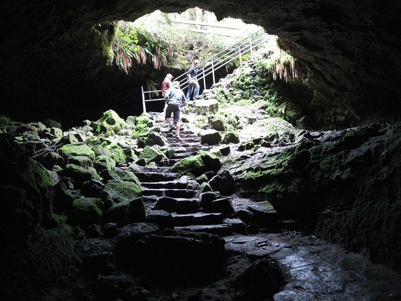
Ape Cave
National monument in Washington State. Mount St. Helens National Volcanic Monument is a U.S. National Monument that includes the area around Mount St. Helens in Washington. It was established on August 27, 1982, by U.S. President Ronald Reagan, following the 1980 eruption. The 110,000 acre National Volcanic Monument was set aside for research, recreation, and education. Inside the monument, the environment is left to respond naturally to the disturbance. It was the third national monument to be managed by the U.S. Forest Service.
At dedication ceremonies on May 18, 1983, Max Peterson, head of the USFS, said, "we can take pride in having preserved the unique episode of natural history for future generations." Since then, many trails, viewpoints, information stations, campgrounds, and picnic areas have been established to accommodate the increasing number of visitors each year.
Beginning in 1983, visitors have been able to drive to Windy Ridge, only 4 miles (6.4 km) northeast of the crater.
Mountain climbing to the summit of the volcano has been allowed since 1986.[1]
Address: Forest Rd. 8303, Mount St. Helens
Ape Canyon
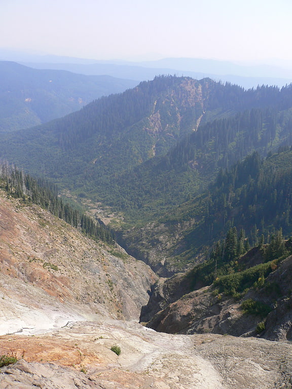
Ape Canyon is a gorge along the edge of the Plains of Abraham, on the southeast shoulder of Mount St. Helens in the state of Washington. The gorge narrows to as close as eight feet at one point. The name alludes to a reported encounter with several "apemen" in 1924, an event later incorporated into Bigfoot folklore.
Ape Canyon was heavily impacted by the 1980 eruption of Mount St. Helens. Adjacent to the steep rocky canyon is the present Ape Canyon trail, popular with hikers and mountain bikers. On the south side of the mountain is another feature named Ape Cave.[2]
Crater Glacier
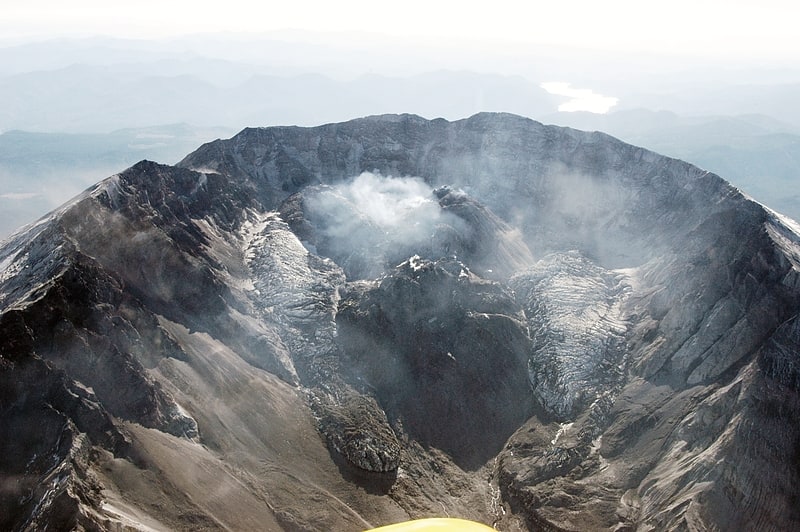
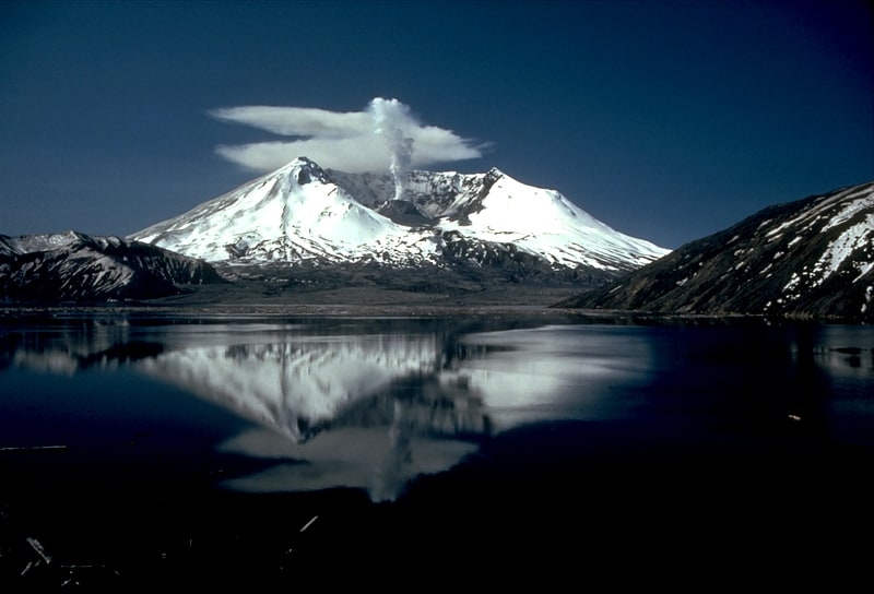
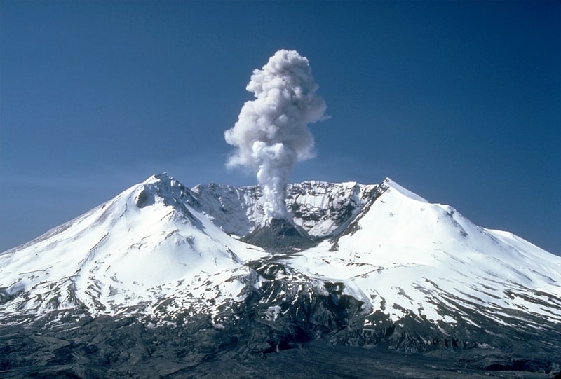
Glacier in Washington State. The Crater Glacier is a geologically young glacier that is located on Mount St. Helens, in the U.S. state of Washington. The glacier formed after the 1980 Eruption and due to its location, the body of ice grew rapidly, unknown to the public for nearly 20 years. The glacier once contained ice caves in the smooth ice before the 2004-2008 volcanic activity. The growth of the lava dome and volcanic eruptions from 2004 to 2008 significantly altered the appearance of the glacier. In the same time period, several agencies decided to put an official name on the glacier which, at first, was Tulutson Glacier. A later decision made Crater Glacier the official glacier name. Despite the volcanic activity, the glacier continued to advance and by mid-2008, the glacier completely encircled the lava domes. In addition, new glaciers have formed around Crater Glacier as well.[3]
Spirit Lake
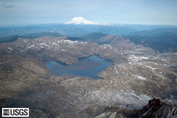
Lake in Washington State. Spirit Lake is a lake in Skamania County, Washington, United States, located north of Mount St. Helens. It was a popular tourist destination for many years until Mount St. Helens erupted in 1980. Previously there had been six camps on the shore of Spirit Lake: Boy Scout, the Girl Scout Camp at Spirit Lake, two YMCA camps, Harmony Fall Lodge, and another for the general public. There were also several lodges accessible to visitors, including Spirit Lake Lodge and Mt. St. Helens Lodge. The latter was owned and operated by Harry R. Truman, a noted victim of the volcano's 1980 eruption.[4]
Mount St. Helens National Volcanic Monument
National monument in Washington State. Mount St. Helens National Volcanic Monument is a U.S. National Monument that includes the area around Mount St. Helens in Washington. It was established on August 27, 1982, by U.S. President Ronald Reagan, following the 1980 eruption. The 110,000 acre National Volcanic Monument was set aside for research, recreation, and education. Inside the monument, the environment is left to respond naturally to the disturbance. It was the third national monument to be managed by the U.S. Forest Service.
At dedication ceremonies on May 18, 1983, Max Peterson, head of the USFS, said, "we can take pride in having preserved the unique episode of natural history for future generations." Since then, many trails, viewpoints, information stations, campgrounds, and picnic areas have been established to accommodate the increasing number of visitors each year.
Beginning in 1983, visitors have been able to drive to Windy Ridge, only 4 miles (6.4 km) northeast of the crater.
Mountain climbing to the summit of the volcano has been allowed since 1986.[5]
Mount Saint Helens
Stratovolcano in Washington State. Mount St. Helens is an active stratovolcano located in Skamania County, Washington in the Pacific Northwest region of the United States. It lies 52 miles northeast of Portland, Oregon and 98 miles south of Seattle. Mount St. Helens takes its English name from the British diplomat Lord St Helens, a friend of explorer George Vancouver who surveyed the area in the late 18th century. The volcano is part of the Cascade Volcanic Arc, a segment of the Pacific Ring of Fire.
Mount St. Helens is best known for its major eruption on May 18, 1980, the deadliest and most economically destructive volcanic event in U.S. history. Fifty-seven people were killed; 200 homes, 47 bridges, 15 miles (24 km) of railways, and 185 miles (298 km) of highway were destroyed. A massive debris avalanche, triggered by a magnitude 5.1 earthquake, caused a lateral eruption that reduced the elevation of the mountain's summit from 9,677 ft (2,950 m) to 8,363 ft (2,549 m), leaving a 1 mile (1.6 km) wide, horseshoe-shaped crater. The debris avalanche was 0.6 cubic miles (2.5 km3) in volume. The 1980 eruption disrupted terrestrial ecosystems near the volcano. By contrast, aquatic ecosystems in the area greatly benefited from the amounts of ash, allowing life to multiply rapidly. By six years after the eruption, most lakes in the area returned to their normal state.
After its 1980 eruption, the volcano had continuous volcanic activity until 2008. Geologists predict that future eruptions will be more destructive, since the configuration of the lava domes there require more pressure to erupt. Despite this, Mount St Helens is a popular hiking spot, and it is climbed year-round. In 1982, the Mount St. Helens National Volcanic Monument was established by U.S President Ronald Reagan and the U.S Congress.[6]