Discover 5 hidden attractions, cool sights, and unusual things to do in Lolo National Forest (United States). Don't miss out on these must-see attractions: Ch-paa-qn Peak, Lolo Pass, and Blue Mountain. Also, be sure to include Coeur d'Alene Mountains in your itinerary.
Below, you can find the list of the most amazing places you should visit in Lolo National Forest (Montana).
Table of Contents
Ch-paa-qn Peak
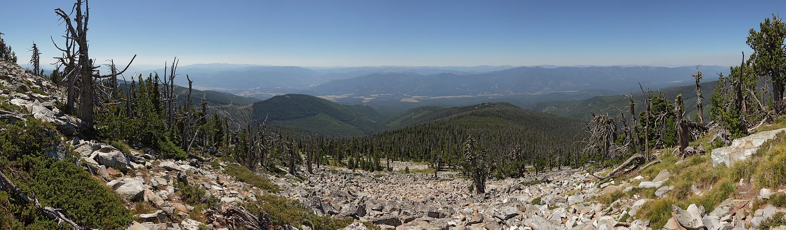
Peak in Montana. Ch-paa-qn Peak is in Missoula County, Montana, United States. It is west of Missoula, Montana. Ch-paa-qn is a Salish word meaning "shining peak".[1]
Lolo Pass
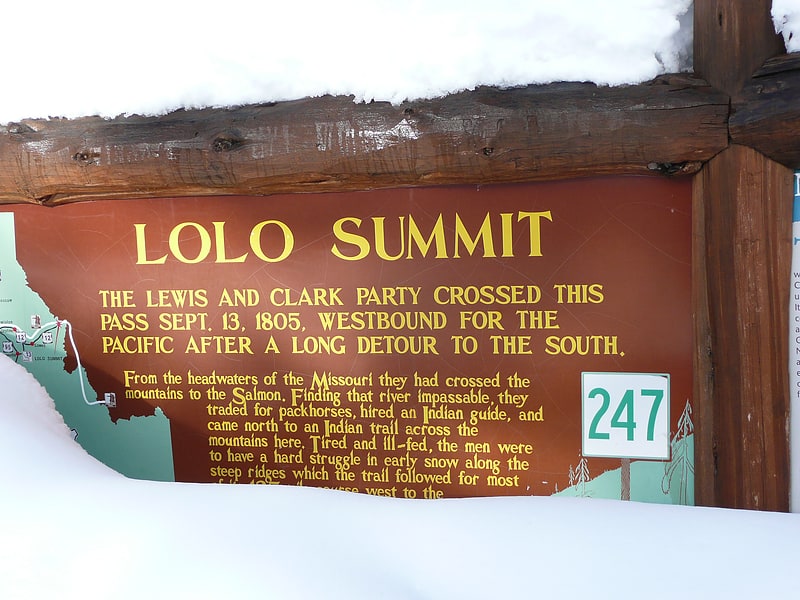
Mountain pass in Idaho. Lolo Pass, elevation 5,233 feet, is a mountain pass in the western United States, in the Bitterroot Range of the northern Rocky Mountains. It is on the border between the states of Montana and Idaho, approximately 40 miles west-southwest of Missoula, Montana.
The pass is the highest point of the historic Lolo Trail, between the Bitterroot Valley in Montana and the Weippe Prairie in Idaho. The trail, known as naptnišaqs, or "Nez Perce Trail" in Salish, was used by Nez Perce in the 18th century, and by the Lewis and Clark Expedition, guided by Old Toby of the Shoshone, on their westward snowbound journey in September 1805. After a winter at Fort Clatsop in present-day northwestern Oregon, the Corps of Discovery returned the following June. The Lolo Trail is a National Historic Landmark, designated for its importance to the Lewis and Clark Expedition, and its role in the 1877 Nez Perce War.
The name of the pass is sometimes said to have been Salish version of the French name Laurence or Laurent, but was probably a regular French nickname. The name Lolo was not used by Lewis and Clark. Its first known mention is in the 1810 journal of David Thompson, who described three fur trappers, probably of French descent, named Michael, Lolo, and Gregoire.
The pass was also used in 1877 during the Nez Perce War as some of the Nez Perce under Chief Joseph tried to escape the U.S. Army. Shortly after crossing the pass, the two sides clashed at the Battle of the Big Hole in Montana.
U.S. Highway 12, belatedly completed in 1962, crosses the pass. At the August dedication ceremony at Lolo Pass attended by thousands, the states' governors, Bob Smylie of Idaho and Tim Babcock of Montana, cut through a ceremonial cedar log with a two-man crosscut saw.
Lolo Hot Springs is 7 miles (11 km) east of the pass in Montana. The first limited services in Idaho are in Powell, 13 miles (21 km) to the west of the pass, then another 65 miles (105 km) to Lowell, at the confluence of the Lochsa and Selway Rivers to form the Middle Fork of the Clearwater. The primary city in Idaho served by U.S. 12 is Lewiston, 170 miles (270 km) west of the pass at the border with Washington, where the Clearwater meets the Snake.
On March 1, 2014, the Idaho Department of Fish and Game announced that 23 wolves had been killed in the Lolo Pass area, in order to boost elk populations.[2]
Address: US Highway 12 at the Idaho - Montana Border, Lolo National Forest
Blue Mountain
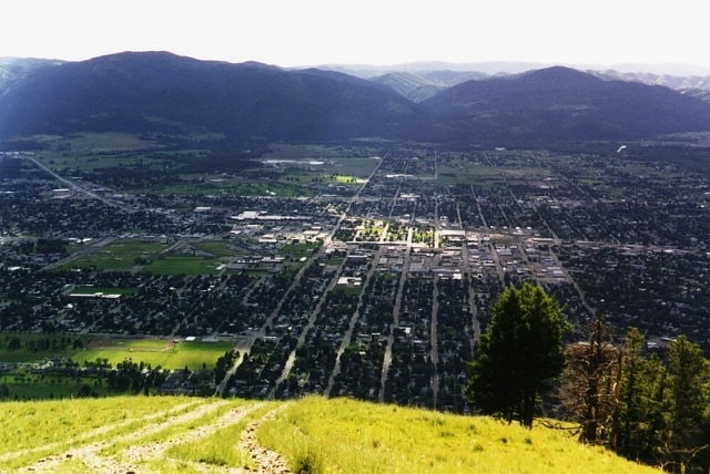
Mountain in Montana. Blue Mountain is the western landmark of the city of Missoula and is a popular recreational destination for golfing hiking, off-road motorcycling, horse riding, shooting and hunting. In the past it was used as a military training site.[3]
Coeur d'Alene Mountains
Mountain range. The Coeur d'Alene Mountains are the northwesternmost portion of the Bitterroot Range, part of the Rocky Mountains, located in northern Idaho and westernmost Montana in the Western United States.
The mountain range spans an area of 2,590 square miles (6,708 km2) and its two highest peaks are the 7,352-foot (2,241 m) Cherry Peak and the 6,837-foot (2,084 m) Patricks Knob.
The range is named after the Coeur d'Alene Tribe.
Several decent-sized roadless areas exist in the Montana portion of the Coeur d'Alenes. Around 43,000 acres (17,000 ha) of roadless country centered on 5,980-foot (1,823 m) Mount Bushnell, south of Thompson Falls, provides good habitat for deer, elk, and mountain lion. This area is/was densely forested with lodgepole pine generated from the Great Fire of 1910. Thirty miles (48 km) of trails provide good hiking opportunities in this roadless area. Talus slopes, grassy parks in the highest reaches, and boggy creek bottoms characterize the landscape here in addition to the forests. Lush riparian areas are home to the Coeur d'Alene salamander and tailed frog.
Just east of the Mount Bushnell area are approximately 40,000 acres (16,000 ha) of roadless land centered on Cherry Peak, highest in the Coeur d'Alenes. Vertical relief exceeds 4,500 feet (1,372 m) in less than two miles (3.2 km) from the Clark Fork River to this area's highest peaks. Several tiny alpine lakes are hidden in cirque basins on Eddy Mountain. Subalpine fir and devil's club are commonly found.
Another 18,000 acres (7,300 ha) are roadless around Patrick's Knob. This area contains thick forests of Douglas-fir and larch in the west and scattered trees in the east; a large and commonly seen herd of bighorn sheep winters here. An old bootlegger's cabin is located on Fourteen Mile Creek.[4]
Scenic Bridge
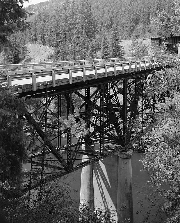
Bridge in Mineral County, Montana. The Scenic Bridge crossing Clark Fork River about 4 miles east of Tarkio in Mineral County, Montana, was built in 1928. It is located at Milepost 0 on Old U.S. Route 10 West. The bridge has also been denoted 24MN304 and MDT No. L31012000+08. It was listed on the National Register of Historic Places in 2010.
The bridge is a riveted Pratt deck truss bridge constructed in 1928. It has three main spans upon reinforced concrete abutments and piers. The bridge is 421 feet (128 m) long in total, with four 19 feet (5.8 m) approach spans, two 77 feet (23 m) deck truss spans, and a 191 feet (58 m) deck truss main span. It is 25 feet (7.6 m) wide, supporting a 24 feet (7.3 m) roadway.
This Pratt deck truss design is visually pleasing and rare. It was chosen by state staff for relatively rare circumstances during 1928 to 1932, after which a version of a Warren truss design was used.[5]