Discover 15 hidden attractions, cool sights, and unusual things to do in Humboldt-Toiyabe National Forest (United States). Don't miss out on these must-see attractions: Lamoille Canyon, Angel Lake, and Dollar Lakes. Also, be sure to include Belmont Courthouse State Historic Park in your itinerary.
Below, you can find the list of the most amazing places you should visit in Humboldt-Toiyabe National Forest (Nevada).
Table of Contents
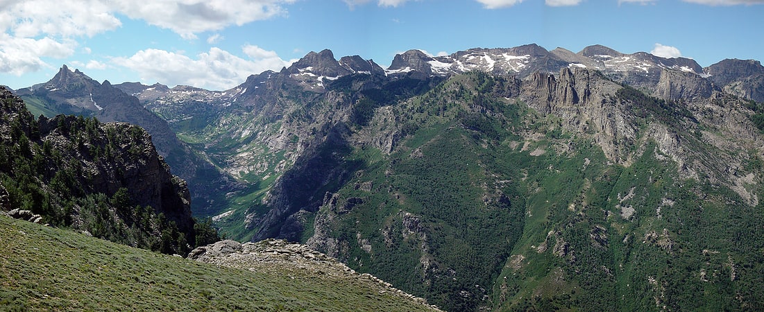
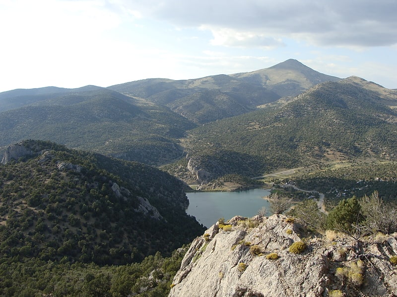
Lamoille Canyon
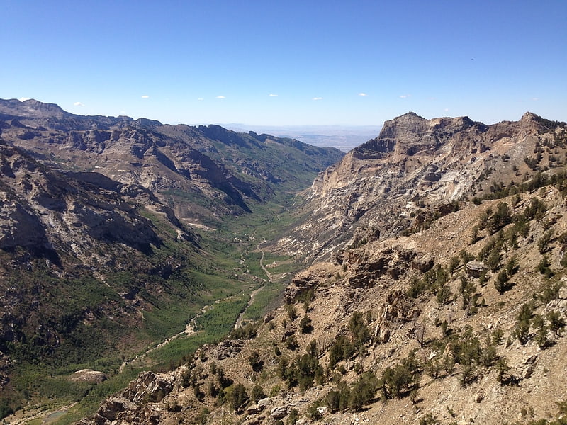
Lamoille Canyon is the largest valley in the Ruby Mountains, located in the central portion of Elko County in the northeastern section of the state of Nevada, in the western United States. Approximately 12 miles in length, it was extensively sculpted by glaciers in previous ice ages.
Lamoille Canyon begins at Liberty Peak at an elevation of 11,032 ft (3,363 m). It quickly descends to a glacial basin now occupied by Lamoille Lake. A nearby granite shelf contains the picturesque Dollar Lakes. Further down the canyon is a large stand of Whitebark pine and the Road's End Trailhead, the high point (8,800 ft (2,700 m)) of Lamoille Canyon Road, which is a National Forest Scenic Byway. This is also the northern terminus of the 38-mile (61 km) Ruby Crest National Recreation Trail, and the start of the much shorter trail to Island Lake.
Road's End is where Lamoille Canyon begins a sweeping turn around the flanks of Thomas Peak, 11,325 ft (3,452 m). The glaciers have deeply carved the canyon, leaving a U-shaped cross section and, high on the side of Thomas Peak, four hanging valleys (including Island Lake). The road then passes the Terraces Picnic Area (featuring more glacial remnants) and Verdi Peak. A nearby nature trail exhibits the diverse plant life in the canyon bottom.
The canyon continues to descend to its junction with Thomas Canyon, which enters from the south. At the head of Thomas Canyon is Mount Fitzgerald (11,215 ft (3,418 m)), and at its outlet is the Thomas Canyon Campground. About a mile below the campground, Lamoille Canyon passes through a narrow slot and then drops quickly to its junction with Right Fork Canyon, which also enters from the south. Near this point are Lamoille Falls, Camp Lamoille (available for group rental), and the north face of Mount Gilbert (11,120 ft (3,390 m)).
At Camp Lamoille the canyon has descended to 7,100 ft (2,200 m). In the remaining 3 miles it descends another 1,000 ft (300 m) and exits the range at the Powerhouse Picnic Area, the site of a powerhouse built in 1913 for the Elko-Lamoille Power Company. It burned down in 1971, leaving only the foundation. Nearby are the communities of Lamoille and Spring Creek.[1]
Angel Lake
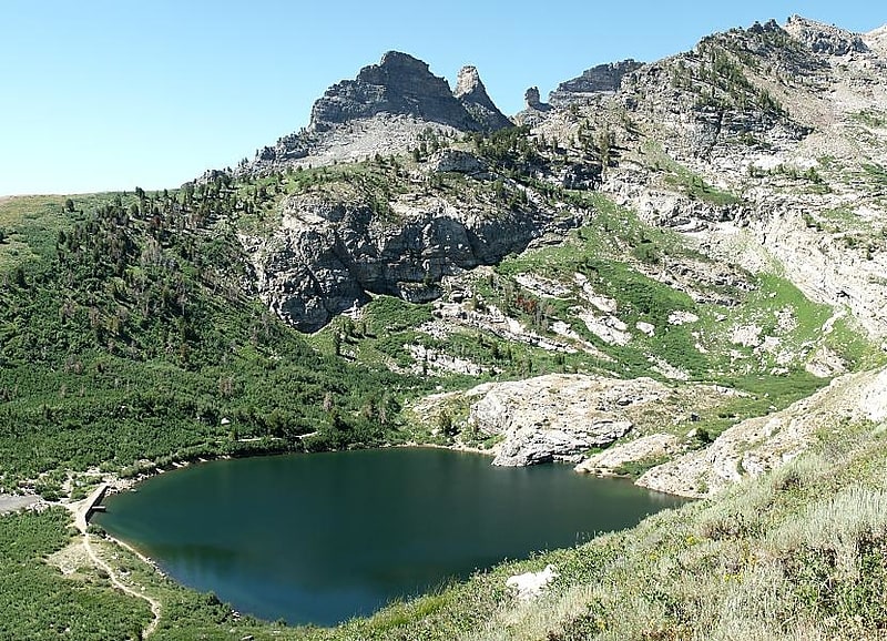
Tarn in Nevada. Angel Lake is a glacial tarn in the northern part of the East Humboldt Range, in central Elko County in the northeastern part of the state of Nevada. It is located at approximately 41°01.6′N 115°05.1′W, and at an elevation of 8378 feet. It has an area of approximately 13 acres, and a depth of up to 29 feet. A 12-mile scenic highway, State Route 231, climbs from Interstate 80's exit 351 in Wells to the eastern shore of the lake.
Located at the base of a steep cirque, the lake is surrounded by high cliffs. Greys Peak (10,674 ft, 3253 m) rises high to the west, and to the south is a group of pinnacles known as Chimney Rock. Far below and to the east lies Clover Valley and the community of Wells.
Angel Lake is one of the most popular recreation sites in the area. On its shore is a 26-site campground, and an 11-site picnic area. The lake itself is available for fishing and non-motorized rafts. A paved trailhead provides access for routes to nearby Smith Lake and to the more distant Greys Lake. Down the access road can be found a trailhead for Winchell Lake, and the Angel Creek Campground.
The lake was named after Warren M. Angel, an early rancher in nearby Clover Valley.[2]
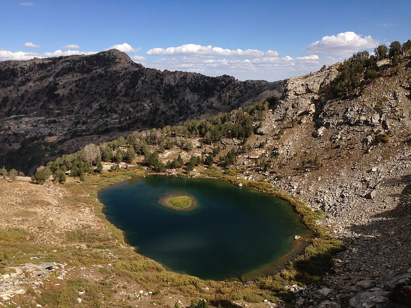
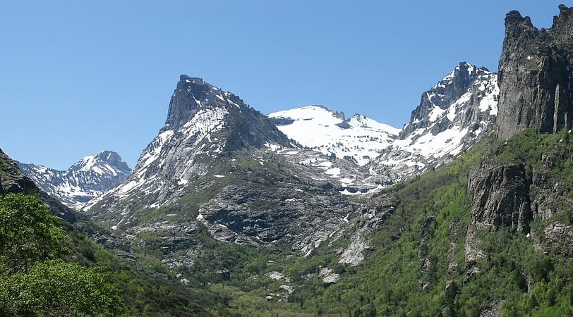
Dollar Lakes
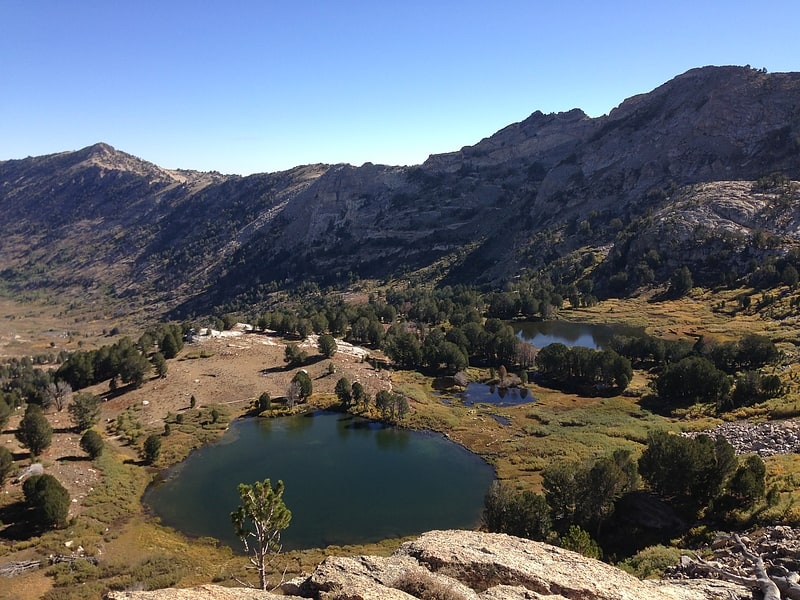
Tarn in Nevada. Dollar Lakes are a group of three glacial tarns in the Ruby Mountains of Elko County, Nevada, United States. They are within the Ruby Mountains Ranger District of the Humboldt-Toiyabe National Forest. The lakes are located near the head of Lamoille Canyon at approximately 40°35′30″N 115°23′6″W, and at an elevation of 9626 feet. They have a combined area of approximately 3 acres, and an estimated depth of up to 15 feet. The Ruby Crest National Recreation Trail runs along the western shore of the lakes.
Dollar and Lamoille lakes are the principal sources of Lamoille Creek, which after exiting the mountains passes through the town of Lamoille, meanders down Lamoille Valley, and then merges with the main branch of the Humboldt River.[3]
Belmont Courthouse State Historic Park
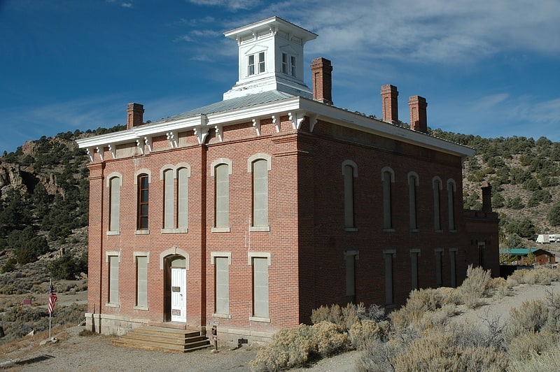
State park in Nye County, Nevada. Belmont Courthouse State Historic Park is a state park of Nevada, USA, in the Toquima Range of Nye County. It is located in the ghost town of Belmont, 45 miles northeast of Tonopah, Nevada.
The partially restored courthouse, which is open to the public, was built in 1876. Most of the restoration was completed by Brett Perchetti. It was the seat of Nye County government until 1905. There are limited picnic tables and public toilets available in Belmont; however, picnic and camping facilities are available at the U.S. Forest Service Pine Creek Campground in the Monitor Valley, located 20 miles (32 km) north of Belmont.
The Courthouse was deeded to the Nevada State Parks in 1974.[4]
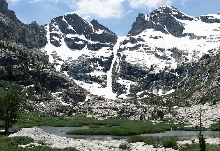
Island Lake
Tarn in Nevada. Island Lake is a glacial tarn in the Ruby Mountains of Elko County, Nevada, United States. It is within the Ruby Mountains Ranger District of the Humboldt-Toiyabe National Forest. The lake is a hanging valley at the end of a 2-mile trail that begins at a parking lot at the end of Lamoille Canyon Road. The lake surface is 9,665 feet above sea level, about 910 feet above the parking lot.
Island Lake has an area of approximately 7.5 acres (3.0 ha) and a depth of up to 22 feet (6.7 m). It is a popular site for day trips, fishing, and camping.
Island Lake is a minor source of flow for Lamoille Creek, which after exiting the mountains passes through the town of Lamoille, meanders down Lamoille Valley, and then merges with the main branch of the Humboldt River.[5]
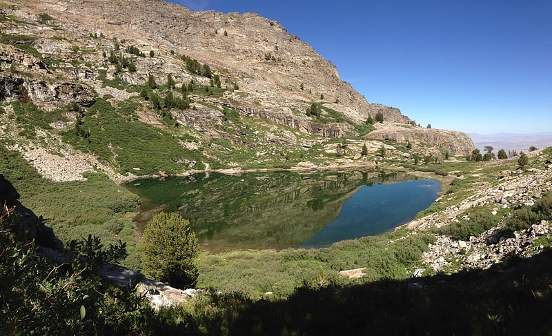
Lamoille Lake

Tarn in Nevada. Lamoille Lake is a glacial tarn in the Ruby Mountains of Elko County, Nevada, United States. It is within the Ruby Mountains Ranger District of the Humboldt-Toiyabe National Forest. The lake is located at the head of Lamoille Canyon, at approximately 40°34.6′N 115°23.7′W, and at an elevation of 9,747 feet. It has an area of approximately 13.6 acres. It is a popular destination for day hikers and fishing, as the Ruby Crest National Recreation Trail passes its eastern shore before beginning a steep climb to Liberty Pass.
Lamoille Lake and the Dollar Lakes are the principal sources of Lamoille Creek, which after exiting the mountains passes through the town of Lamoille, meanders down Lamoille Valley, and then merges with the main branch of the Humboldt River.[6]
Griswold Lake
Tarn in Nevada. Griswold Lake is a glacial tarn in the Ruby Mountains of Elko County, Nevada, United States. It is within the Ruby Mountains Ranger District of the Humboldt-Toiyabe National Forest. The lake is located at the head of Hennen Canyon, at approximately 40°38.1′N 115°29.2′W, and at an elevation of 9222 feet. It has an area of approximately 17 acres, and a depth of up to 20 feet.
Griswold Lake is the principal source of Butterfield Creek, which flows down Hennen Canyon before exiting the mountains into Pleasant Valley. The lake is named after Chauncy "Chan" Griswold, an early rancher in Pleasant Valley and the father of Nevada Governor Morley Griswold. Butterfield Creek was also named after an early rancher, Henry Butterfield.[7]
Ruby Dome
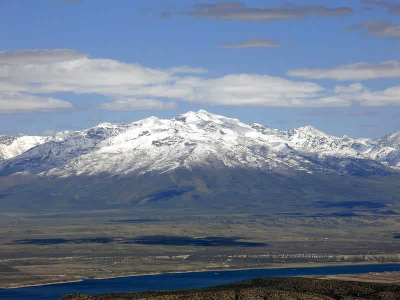
Mountain in Nevada. Ruby Dome is the highest mountain in both the Ruby Mountains and Elko County, in Nevada, United States. It is the twenty-seventh-highest mountain in the state, and also ranks as the thirteenth-most topographically prominent peak in the state. The peak is located about 21 miles southeast of the city of Elko within the Ruby Mountains Ranger District of the Humboldt-Toiyabe National Forest. The mountain rises from a base elevation of about 6,000 feet to a height of 11,387 feet. It is the highest mountain for over 90 miles in all directions.[8]
Verdi Lake
Tarn in Nevada. Verdi Lake is a glacial tarn in the Ruby Mountains of Elko County, Nevada, United States. It is within the Ruby Mountains Wilderness, which is administered by the Ruby Mountains Ranger District of the Humboldt-Toiyabe National Forest. The lake is located at the head of Talbot Canyon at approximately 40°38.9′N 115°21.2′W, and at an elevation of 10,184 feet. Directly to the south rises Verdi Peak. It has an area of approximately 6 acres, and a depth of up to 86 feet.
Verdi Lake is unusual in two respects. It is the highest lake in the Ruby Mountains, and is therefore the last to thaw out in the spring. Also, it does not normally have a surface outlet. Lake water seeps into the soil and emerges as a spring several hundred yards down Talbot Canyon. This is the major source of flow to Talbot Creek, which after exiting the mountains passes near the community of Lamoille, merges with Lamoille Creek, which then meanders down Lamoille Valley and merges with the main branch of the Humboldt River.[9]
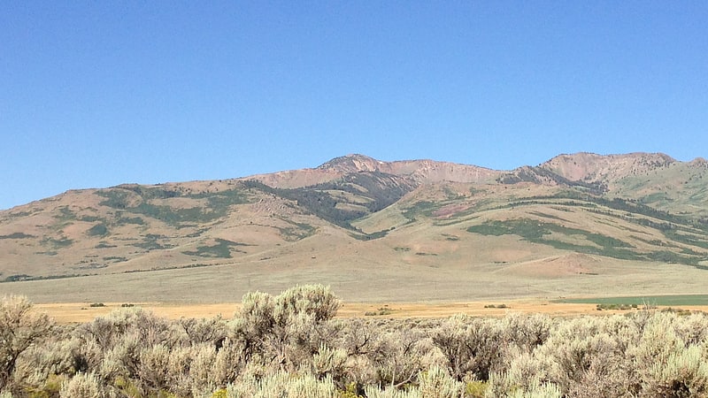
Ruby Mountains
Mountain range in Nevada. The Ruby Mountains are a mountain range, primarily located within Elko County with a small extension into White Pine County, in Nevada, United States. Most of the range is included within the Humboldt-Toiyabe National Forest. The range reaches a maximum elevation of 11,387 feet on the summit of Ruby Dome. To the north is Secret Pass and the East Humboldt Range, and from there the Rubies run south-southwest for about 80 miles. To the east lies Ruby Valley, and to the west lie Huntington and Lamoille Valleys. The Ruby Mountains are the only range of an introduced bird, the Himalayan snowcock, in North America.
The 'Rubies' were named after the garnets found by early explorers. The central core of the range shows extensive evidence of glaciation during recent ice ages, including U-shaped canyons, moraines, hanging valleys, and steeply carved granite mountains, cliffs, and cirques. All of these features can be seen from 12-mile Lamoille Canyon Road, a National Forest Scenic Byway which traverses Lamoille Canyon, entering the range near the town of Lamoille.[10]
Greys Peak
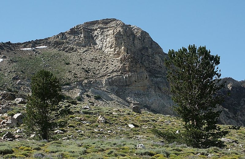
Summit in Nevada. Greys Peak is the northernmost summit of the East Humboldt Range of Elko County in northeastern Nevada about 10 miles southwest of the community of Wells. It rises over 5,000 feet from the Humboldt Valley, making it one of the most visually prominent peaks in the area. To the west are Dennis Flats, Starr Valley, and remote Greys Lake, while to the east are Chimney Rock, Clover Valley, and popular Angel Lake. The summit is the start of a high crest running almost 10 miles to the south.
The peak is named after Enoch Grey, an early homesteader in nearby Starr Valley.[11]
Seitz Canyon
Seitz Canyon is one of the major canyons and valleys within the Ruby Mountains of Elko County, in the northeastern section of the state of Nevada in the western United States. Approximately 5.5 miles in length, it was extensively sculptured by glaciers in previous ice ages. Remote, scenic, and ecologically diverse, it is protected in both the Ruby Mountains Wilderness Area and the Seitz-Echo Research Natural Area.
The main branch of Seitz Canyon begins at the summit of Mt. Silliman, at an elevation of 11,250 feet (3,430 m). This high ridge also includes Mt. Gilbert at 11,120 ft (3,390 m), and an unnamed peak at 11,035 ft (3,363 m). The canyon then drops to the north as a spectacular headwall of over 2,000 ft (610 m) to a nearly level basin that includes Seitz Lake.
It is here that the greatest evidence for glacial sculpturing can be found. The canyon shows a classic U-shaped cross section, and many patches of bare granite still retain the dark patina and striations caused by direct contact with the lower surface of the glacier that once filled this valley.
From Seitz Lake the canyon makes a more gradual descent to its middle section 8,000 ft (2,400 m), an area that includes a dense stand of aspen trees and beaver ponds. It then descends again to its large lower section 7,000 ft (2,100 m), which includes an open forest of aspen and white fir trees, sagebrush flats, and the junction with the south branch of the canyon. Towering 1,500 ft (460 m) above are granite cliffs and pinnacles.
Like its neighbor to the north, Lamoille Canyon, Seitz Canyon is branched. The southern fork begins at the highest point of the range, the north face of Ruby Dome 11,387 ft (3,471 m). Nearby are two other tall peaks known locally as Ruby Pyramid and Seitz Peak. The canyon descends steeply in four steps before merging with the main branch of the canyon.
This southern branch of the canyon may have once drained into the adjacent smaller valley of Thompson Creek. By this theory, early glaciers were able to break through the narrow ridge separating the canyons, and subsequently flow into the deeper main branch of Seitz Canyon. The result is that Thompson Creek is now a 'reverse' hanging valley, with its source perched 1,200 ft (370 m) up the wall of Seitz Canyon. This merger also led to a large area of exposed granite at the bottom of Seitz Canyon, and a steep cascade of the stream nearly 1,000 ft (300 m) long.
The merger of the two branches of Seitz Canyon forms Rabbit Creek, which drains into Pleasant Valley and then meanders across Lamoille Valley before merging with the Humboldt River near the community of Halleck. As the stream exits the range, it passes the last unusual feature of Seitz Canyon, the best examples of lateral moraines in the Ruby Mountains. These ridges were formed as the glaciers dropped the rocks they had scraped from higher slopes. The moraines show the curve the glaciers took as they exited the confines of the rocky canyon, and exhibit multiple secondary ridges produced as the glaciers retreated at the end of the last ice age.
The canyon (and the lake within it) was named after brothers George and Edward Seitz, who were early ranchers in Pleasant Valley. George eventually left the area, but Ed Seitz became the sheriff of Elko County in 1869.[12]
McAfee Peak
Mountain in Nevada. McAfee Peak is the highest mountain in the Independence Mountains of northern Elko County, Nevada, United States. It ranks twenty-first among the most topographically prominent peaks in the state. The peak is located within the Mountain City Ranger District of the Humboldt-Toiyabe National Forest.[13]
Cave Lake State Park
National recreation area in White Pine County, Nevada. Cave Lake State Park is a public recreation area occupying more than 4,000 acres in the Schell Creek Range, adjacent to Humboldt National Forest, in White Pine County, Nevada. The state park is located at an elevation of 7,300 feet five miles southeast of Ely and is accessed via U.S. Route 50 and Success Summit Road. It features a 32-acre reservoir for fishing and flat-wake boating.[14]
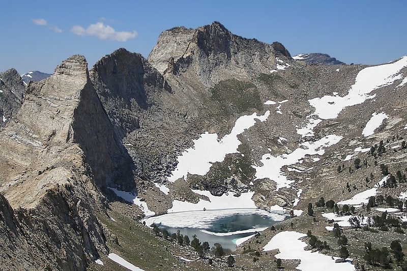
Seitz Lake
Tarn in Nevada. Seitz Lake is a glacial tarn in the Ruby Mountains, in Elko County in the northeastern part of the state of Nevada. It is located near the head of Seitz Canyon at approximately 40°38.2′N 115°27.4′W, and at an elevation of 8915 feet. It has an area of approximately 17 acres, and a depth of up to 20 feet.
Seitz Lake is a major source of flow to Rabbit Creek (formerly known as Seitz Creek), which after exiting the mountains passes near the community of Spring Creek, meanders down Lamoille Valley, and then merges with the main branch of the Humboldt River between Halleck and Elburz, NV.
The lake was named after brothers George and Edward Seitz, who were early ranchers in Pleasant Valley. George eventually left the area, but Ed Seitz became the sheriff of Elko County in 1869.[15]
Address: 11475 Magnolia Ave, Humboldt-Toiyabe National Forest