Discover 15 hidden attractions, cool sights, and unusual things to do in Death Valley National Park (United States). Don't miss out on these must-see attractions: Titus Canyon, Scotty's Castle, and Ubehebe Crater. Also, be sure to include Darwin Falls in your itinerary.
Below, you can find the list of the most amazing places you should visit in Death Valley National Park (California).
Table of Contents
Titus Canyon
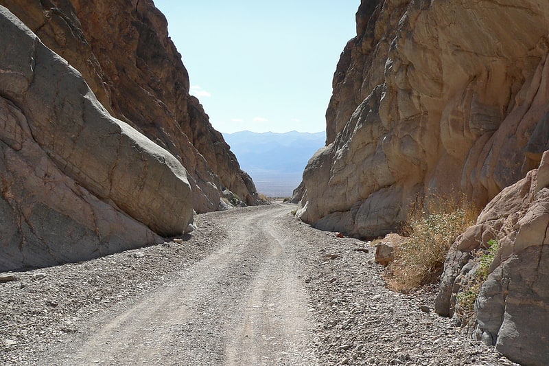
Geographical feature. Titus Canyon is a deep, narrow gorge cut into the steep face of the Grapevine Mountains of the Mojave Desert, within Death Valley National Park in southeastern California and southwestern Nevada. The canyon features limestone rock formations, petroglyphs, and native plants and wildlife.[1]
Scotty's Castle
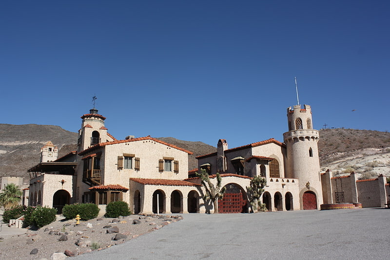
Historical landmark in California. Scotty's Castle is a two-story Mission Revival and Spanish Colonial Revival style villa located in the Grapevine Mountains of northern Death Valley in Death Valley National Park, California, US. Scotty's Castle is named for gold prospector Walter E. Scott, although Scott never owned it, nor is it an actual castle.
The ranch is located about 45 miles north of Stovepipe Wells, California, via California State Route 190 to Scotty's Castle Road, or about a three-hour drive from Las Vegas, Nevada.
The property was severely damaged by flooding in October 2015 and is not currently open to the public.[2]
Ubehebe Crater
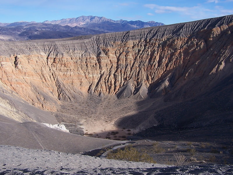
Scenic spot in Inyo County, California. Ubehebe Crater is a large volcanic crater of the Ubehebe Craters volcanic field in the northern half of Death Valley, in Death Valley National Park, California, United States.[3]
Darwin Falls
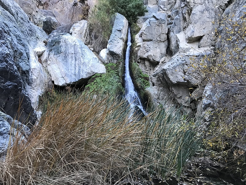
Waterfall in California. Darwin Falls is a waterfall located on the western edge of Death Valley National Park near the settlement of Panamint Springs, California. Although there exists a similarly named Darwin Falls Wilderness adjacent to the falls, the falls themselves are located in and administered by Death Valley National Park and the National Park Service. There are several falls, but they are mainly divided into the upper and lower, with a small grotto in between. At a combined 80 feet, it is the highest waterfall in the park. The canyon is walled by dramatic plutonic rock.
Darwin Creek is one of the four perennial streams in three million-acre (12,000 km²) Death Valley National Park. Darwin Falls and Creek are fed by the Darwin Wash, which is in turn fed by the volcanic tableland of the Darwin Bench between the Inyo Mountains and the Argus Range. The small, narrow valley where the creek and falls are located features a rare collection of riparian greenery in the vast desert and is home to indigenous fauna such as quail. The falls themselves support several small fern gullys.
Darwin Falls, the Darwin Falls Wilderness, the nearby town of Darwin, California, and all other areas named "Darwin" in the vicinity are named after Dr. Darwin French (1822–1902), a local rancher, miner, and explorer.[4]
Oasis at Death Valley
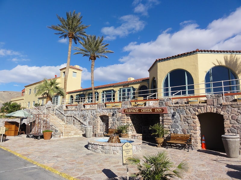
Resort in Inyo County, California. The Oasis at Death Valley, formerly called Furnace Creek Inn and Ranch Resort, is a luxury resort in Furnace Creek, on private land within the boundaries of California's Death Valley National Park. It is owned and operated by Xanterra Parks and Resorts.
The Inn at Death Valley is a member of Historic Hotels of America, the official program of the National Trust for Historic Preservation.[5]
Address: Hwy 190, 92328 Death Valley
Devils Hole

Geological formation in Nevada. Devils Hole is a geologic formation located in a detached unit of Death Valley National Park and surrounded by the Ash Meadows National Wildlife Refuge, in Nye County, Nevada, in the Southwestern United States.
Devils Hole is habitat for the only naturally occurring population of the endangered Devils Hole pupfish (Cyprinodon diabolis). The 40 acres (16 ha) unit is part of the Ash Meadows complex, an area of desert uplands and spring-fed oases that was designated as a National Wildlife Refuge in 1984.[6]
Harmony Borax Works
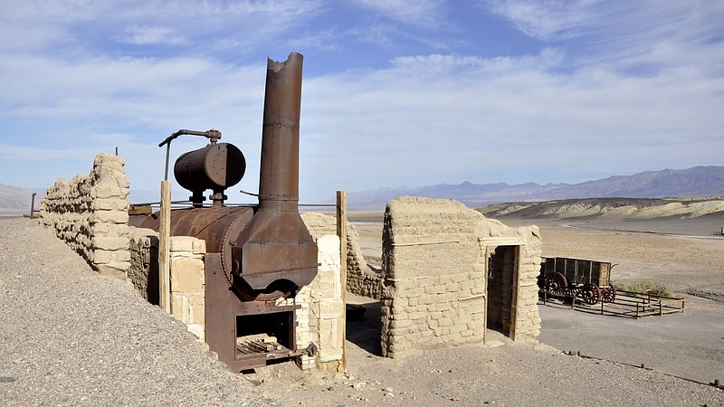
Historical place in the Furnace Creek, California. The Harmony Borax Works is located in Death Valley at Furnace Creek Springs, then called Greenland. It is now located within Death Valley National Park in Inyo County, California. It is on the National Register of Historic Places.[7]
Address: Harmony Borax Works Interpretive Trail, 92328 Furnace Creek
Mosaic Canyon
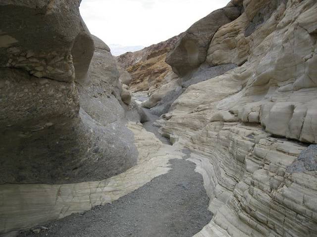
Natural attraction, Canyon, Park
Address: Route 190, 92328 Death Valley National Park
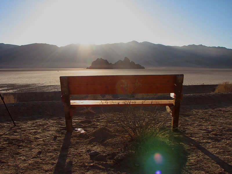
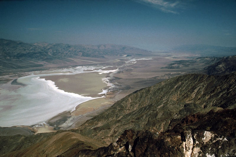
Badwater Basin
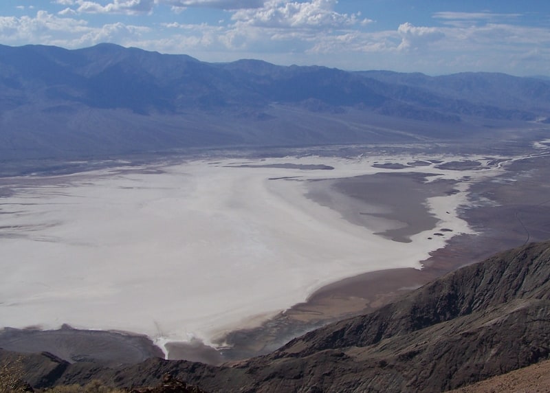
Salty basin sitting below sea level. Badwater Basin is an endorheic basin in Death Valley National Park, Death Valley, Inyo County, California, noted as the lowest point in North America and the United States, with a depth of 282 ft below sea level. Mount Whitney, the highest point in the contiguous 48 United States, is only 84.6 miles to the northwest.
The site itself consists of a small spring-fed pool of "bad water" next to the road in a sink; the accumulated salts of the surrounding basin make it undrinkable, thus giving it the name. The pool does have animal and plant life, including pickleweed, aquatic insects, and the Badwater snail.
Adjacent to the pool, where water is not always present at the surface, repeated freeze–thaw and evaporation cycles gradually push the thin salt crust into hexagonal honeycomb shapes.
The pool is not the lowest point of the basin: the lowest point (which is only slightly lower) is several miles to the west and varies in position, depending on rainfall and evaporation patterns. The salt flats are hazardous to traverse (in many cases being only a thin white crust over mud), and so the sign marking the low point is at the pool instead. The basin was considered the lowest elevation in the Western Hemisphere until the discovery of Laguna del Carbón in Argentina at −344 ft (−105 m).[8]
The Grandstand
Mountain in California. The Grandstand is a natural rock monolith located near the northerly end of Racetrack Playa, north of Death Valley in the Cottonwood Mountains of Death Valley National Park, in Inyo County, California.[9]
Telescope Peak
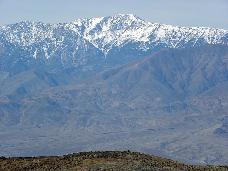
Mountain in California. Telescope Peak is the highest point within Death Valley National Park, in the U.S. state of California. It is also the highest point of the Panamint Range, and lies in Inyo County. From atop this desert mountain one can see for over one hundred miles in many directions, including west to Mount Whitney, and east to Charleston Peak. The mountain was named for the great distance visible from the summit.[10]
Teakettle Junction
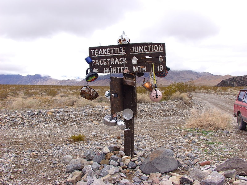
Teakettle Junction is a road junction in Inyo County, California. It lies at an elevation of 4,150 feet in Death Valley near the Racetrack Playa and Ubehebe Crater.
At the junction where the unimproved road from Ubehebe Crater meets roads to the Racetrack Playa and Hunter Mountain, there is a sign reading "Teakettle Junction." While the origin of the name is unknown, it has become a tradition for visitors to attach teakettles to the sign with messages written on them. National Park Service rangers will sometimes remove a number of teakettles when there are too many.
The rock at the junction includes the bedrock sandstone of the Eureka Quartzite strata.[11]
Death Valley
Death Valley is a desert valley in Eastern California, in the northern Mojave Desert, bordering the Great Basin Desert. During summer, it is one of the hottest places on Earth, along with deserts in the Middle East and the Sahara.
Death Valley's Badwater Basin is the point of lowest elevation in North America, at 282 feet (86 m) below sea level. It is 84.6 miles (136.2 km) east-southeast of Mount Whitney, the highest point in the contiguous United States, with an elevation of 14,505 feet (4,421 m). On the afternoon of July 10, 1913, the United States Weather Bureau recorded a high temperature of 134 °F (56.7 °C) at Furnace Creek in Death Valley, which stands as the highest ambient air temperature ever recorded on the surface of the Earth. This reading, however, and several others taken in that period, a century ago, are in dispute by some modern experts.
Lying mostly in Inyo County, California, near the border of California and Nevada, in the Great Basin, east of the Sierra Nevada mountains, Death Valley constitutes much of Death Valley National Park and is the principal feature of the Mojave and Colorado Deserts Biosphere Reserve. It runs from north to south between the Amargosa Range on the east and the Panamint Range on the west; the Grapevine Mountains and the Owlshead Mountains form its northern and southern boundaries, respectively. It has an area of about 3,000 sq mi (7,800 km2). The highest point in Death Valley National Park is Telescope Peak, in the Panamint Range, which has an elevation of 11,043 feet (3,366 m).[12]
Lake Manly
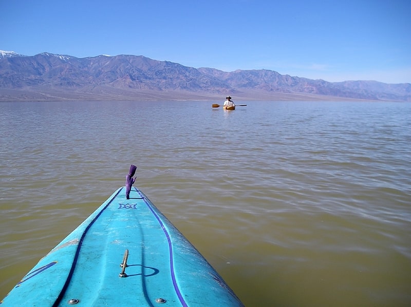
Lake in California. Lake Manly was a pluvial lake in Death Valley, California, covering much of Death Valley with a surface area of 1,600 square kilometres during the so-called "Blackwelder stand". Water levels varied through its history, and the chronology is further complicated by active tectonic processes that have modified the elevations of the various shorelines of Lake Manly; during the Blackwelder stage they reached 47–90 metres above sea level. The lake received water mainly from the Amargosa River and at various points from the Mojave River and Owens River. The lake and its substantial catchment favoured the spread of a number of aquatic species, including some lizards, pupfish and springsnails. The lake probably supported a substantial ecosystem, and a number of diatoms developed there.
In Death Valley, lakes existed during different times in the geological past. After some poorly defined lake stages during the Miocene, Pliocene and early Pleistocene, the first large lake stage occurred about 185,000–128,000 years ago during the Tahoe glacial stage and formed the Blackwelder shorelines. This lake was the largest known Lake Manly; theories that the lake merged with Lake Mojave farther south or even overflowed into the Colorado River close to Ludlow and across several other basins are, however, questionable. After the drying of this lake a later lake stage occurred 35,000–10,000 years ago during the Tioga/Wisconsin glaciation; this lake was smaller than the Blackwelder lake. During the Holocene, the lake disappeared; today only ephemeral lakes occur in Death Valley during strong floods.
This lake is one among many major lakes that formed in the Great Basin, the best researched of which are Lake Lahontan and Lake Bonneville. Decreasing temperatures and thus decreased evaporation rates as well as increased precipitation rates during the ice ages were responsible for the formation of these lake systems. Lake Manly collected the overflow from a number of lakes including Lake Tecopa, Mono Lake, Owens Lake, Searles Lake, Lake Panamint, Lake Mojave, Lake Dumont and Lake Manix. Not all of them existed or drained into Lake Manly simultaneously.[13]
Dante's View
Dante's View is a viewpoint terrace at 1,669 m height, on the north side of Coffin Peak, along the crest of the Black Mountains, overlooking Death Valley. Dante's View is about 25 km south of Furnace Creek in Death Valley National Park.[14]
Address: Dante's View Rd, Death Valley National Park