Discover 11 hidden attractions, cool sights, and unusual things to do in Cape Cod National Seashore (United States). Don't miss out on these must-see attractions: Long Point Light, Race Point Light, and Marconi Beach. Also, be sure to include Marconi Wireless Station Site in your itinerary.
Below, you can find the list of the most amazing places you should visit in Cape Cod National Seashore (Massachusetts).
Table of Contents
Long Point Light
Lighthouse in Provincetown, Massachusetts. Long Point Light Station is a historic lighthouse at the northeast tip of Long Point in Provincetown, Massachusetts. As a navigational aid, it marks the southwest edge of the entrance to Provincetown Harbor. The United States Coast Guard Light List describes it simply as a "white square tower". The light it casts is green, occulting every 4 seconds, and, at a focal height of 35.5 feet above mean sea level, has a visible range of 8 nautical miles. When the weather affords low-visibility, one can hear the station's fog horn – sounding a single blast for two seconds, and repeating every 15 seconds – as it seems to call out for its nearly-identical closest neighbor, the Wood End Light.[1]
Address: Long Point Beach, 02657 Provincetown (Outer Cape)
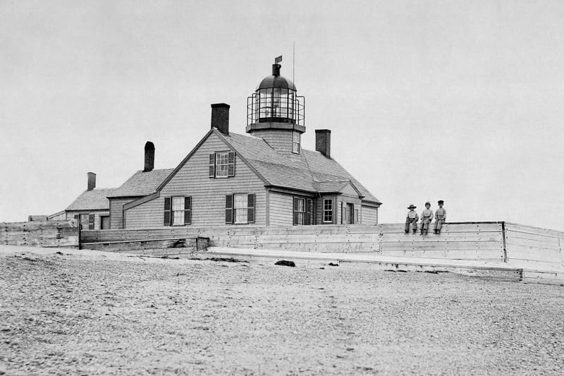
Race Point Light
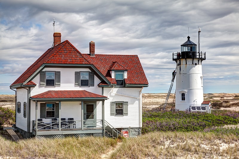
Lighthouse in Provincetown, Massachusetts. Race Point Light is a historic lighthouse on Cape Cod, in Provincetown, Massachusetts; it is on the National Register of Historic Places. The original tower, first illuminated in 1816, was replaced in 1876 with the current 45-foot tall iron-plated tower and a new keeper's dwelling. The American Lighthouse Foundation operates the property and rents out two buildings for overnight stays. The actual light is maintained by the Coast Guard. The site is reached by walking about 45 minutes over sand; with a National Park Service Oversand Permit, a four-wheel-drive vehicle can be used.[2]
Address: Race Point Beach, 02657 Provincetown (Outer Cape)
Marconi Beach
Beach in Wellfleet, Massachusetts. Marconi Beach is part of the Cape Cod National Seashore in Wellfleet, Massachusetts. The beach is named for Italian inventor Guglielmo Marconi. In 1903, the first transatlantic wireless communication originating in the United States was successfully transmitted from nearby Marconi Station; a message from U.S. President Theodore Roosevelt to King Edward VII of the United Kingdom. The beach was also used by the former Camp Wellfleet for artillery and rocket testing.
There is a broad, sweeping view of the Atlantic Ocean and Cape Cod Bay from the overlook atop the steep sand cliff above the beach. The National Park Service has built a display on-site that describes the history of wireless telegraphy, though parts have been removed due to beach erosion. During the summer season, restrooms and outdoor showers are available to beachgoers, along with on-site parking and access from the nearby bike trail via a two-lane road. Admission is charged for vehicles and pedestrians at the rate for all Cape Cod National Seashore beaches.
Marconi Beach is popular among locals and tourists for surfing and boogie boarding. It is one of five Cape Cod national seashore beaches that are on the ocean side of the Cape, generally providing a better surf than beaches on the bay side. Low tide exposes a fairly flat stretch of beach, making it also popular for skimboarding.
Seals can frequently be seen in the waters at Marconi, frequently confounding the efforts of surfcasters to land the bluefish and striped bass cruising beyond the breakers during the summer and fall.[3]
Marconi Wireless Station Site
Historical place in Wellfleet, Massachusetts. The Marconi Wireless Station Site in South Wellfleet, Massachusetts, is the site of the first transatlantic wireless communication between the United States and Europe, on January 18, 1903. At this location, now in the Cape Cod National Seashore, inventor Guglielmo Marconi erected a large antenna array on four 210-foot wooden towers, and established a transmitting station powered by kerosene engines that produced the 25,000 volts of electricity needed to send signals to a similar station in Poldhu, Cornwall, United Kingdom. The first transmission received in North America by Marconi was at Signal Hill, St. John's, Newfoundland and Labrador in 1901; Glace Bay, Nova Scotia was the site of the first such two-way transmission, in 1902. One of the station's most notable roles occurred with the sinking of the RMS Titanic in April 1912. Operators at the station were able to alert the RMS Carpathia so that the rescue of some of the Titanic's passengers could be effected. The station was shut down in 1917 in part over concerns about its use in World War I, but also because its towers were threatened with erosion. In 1920, usable materials and equipment were removed from the site, and it was abandoned. Erosion has taken its toll over the years since then, and there was little left as of the date of the National Park Service brochure. No trace of the site remains as of September 2014; the sea has claimed it all.
Marconi had moved the station to Chatham by 1912 and the Titanic and Carpathia communications were done from there. There is debate of whether the Wellfleet station was ever put into commercial operation.
The site was listed on the National Register of Historic Places in 1975.[4]
Address: Six miles north of Salt Pond Visitor Center, Cape Cod National Seashore (Outer Cape)
Nauset Light
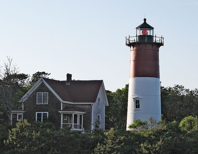
Lighthouse in Eastham, Massachusetts. Nauset Light, officially Nauset Beach Light, is a restored lighthouse on the Cape Cod National Seashore near Eastham, Massachusetts, erected in 1923 using the 1877 tower that was moved here from the Chatham Light. It is listed on the National Register of Historic Places. The tower is a cast-iron plate shell lined with brick and stands 48 feet high. The adjacent oil house is made of brick and has also been restored. Fully automated, the beacon is a private aid to navigation. Tours of the tower and oil house are available in summer from the Nauset Light Preservation Society which operates, maintains and interprets the site. The tower is located adjacent to Nauset Light Beach.[5]
Address: 2 Nauset Light Beach Rd, 02642-1729 Eastham (Outer Cape)
Highland Light
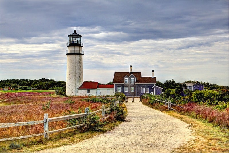
Lighthouse in Truro, Massachusetts. The Highland Light is an active lighthouse on the Cape Cod National Seashore in North Truro, Massachusetts. The current tower was erected in 1857, replacing two earlier towers that had been built in 1797 and 1831. It is the oldest and tallest lighthouse on Cape Cod.
The grounds are open year-round, while the light is open to the public from May until late October, with guided tours available. Highland Light is owned by the National Park Service, and was cared for by the Highland Museum and Lighthouse, Inc. until 2014 when Eastern National, another non-profit group, took over the contract to operate the facility as a tourist attraction. The United States Coast Guard operates the light as an aid to navigation. The United States Navy ship USS Highland Light (IX-48) was named after the light. It is listed on the National Register of Historic Places as Highland Light Station.[6]
Edward Penniman House and Barn
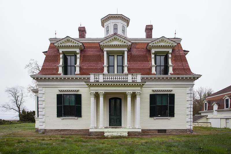
The Edward Penniman House and Barn is a historic site in Eastham, Massachusetts, United States, on Fort Hill, which is currently protected by the Cape Cod National Seashore and home to Indian Rock.
The house was built in 1868 and added to the National Register of Historic Places in 1976.[7]
Address: Fort Hill Road, 02642 Eastham (Outer Cape)
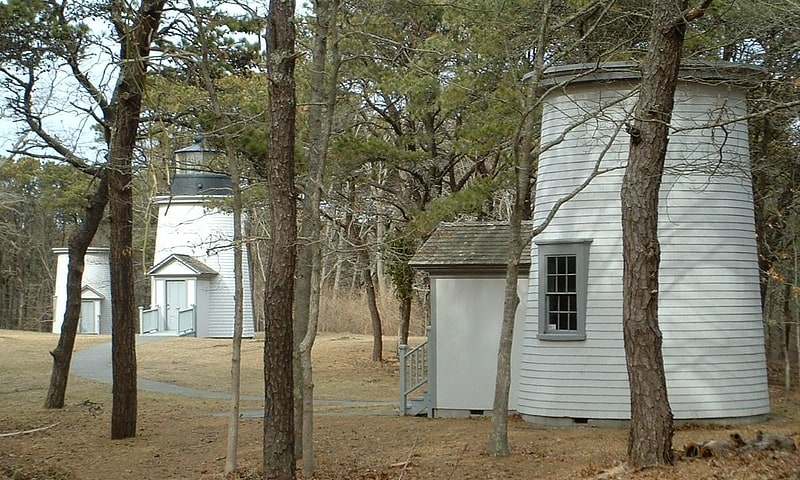
Wood End Light
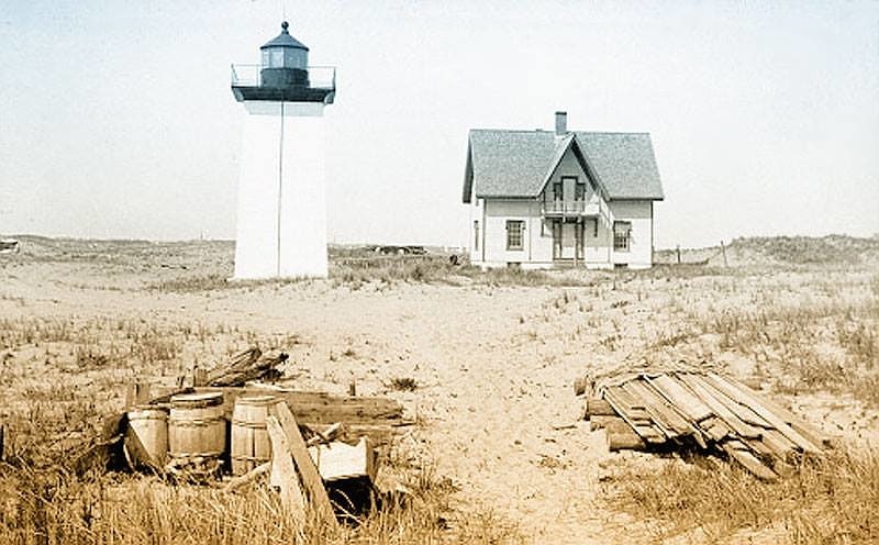
Lighthouse in Provincetown, Massachusetts. Wood End Light Lookout Station is a historic lighthouse, located at the southwest end of Long Point in Provincetown, Massachusetts. It is located at Wood End, near the southernmost extent of the Provincetown Spit, and acts as a navigational aid to vessels on their approach to Provincetown Harbor. The Long Point Light Station, further down the peninsula at the tip of Long Point is an identical design and completed in 1875, three years after Wood End Light.
The light was first illuminated on November 20, 1872, and added to the National Register of Historic Places in 1987. In 1981, Wood End Light became the first Massachusetts lighthouse to be converted to use solar energy to power the light and fog signal equipment.
In 1896 a wooden keeper's house was built, as well as a storage shed and oil house. With the changing times and no need to man the light station, it was decided in 1961 to raze the buildings leaving just the tower and oil house.[8]
Three Sisters of Nauset
Historical landmark in Eastham, Massachusetts. The Three Sisters of Nauset are a trio of historic lighthouses off Cable Road in Eastham, Massachusetts. The original three brick towers fell into the sea due to erosion in 1890 and were replaced with wooden towers on brick foundations in 1892. The Sisters were decommissioned in 1911 but one of them, the Beacon, was moved back from the shoreline and attached to the keeper's house. It continued to operate but was replaced by a new steel tower, the Nauset Light, in 1923.[9]
Jenny Lind Tower
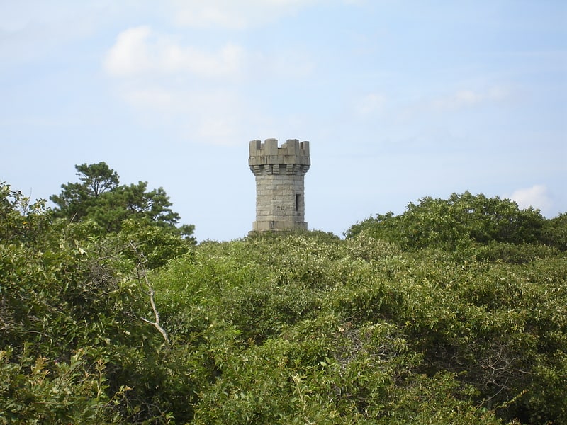
Tower in Truro, Massachusetts. The Jenny Lind Tower is a stone tower located in North Truro, Massachusetts. It is named after the 19th-century opera singer Jenny Lind, who is rumored to have climbed the tower when it was located in Boston to prevent a riot among people who were unable to attend her concert. It is located roughly between the Highland Light lighthouse and North Truro Air Force Station. It is seventy feet tall.[10]
Pine Grove Cemetery
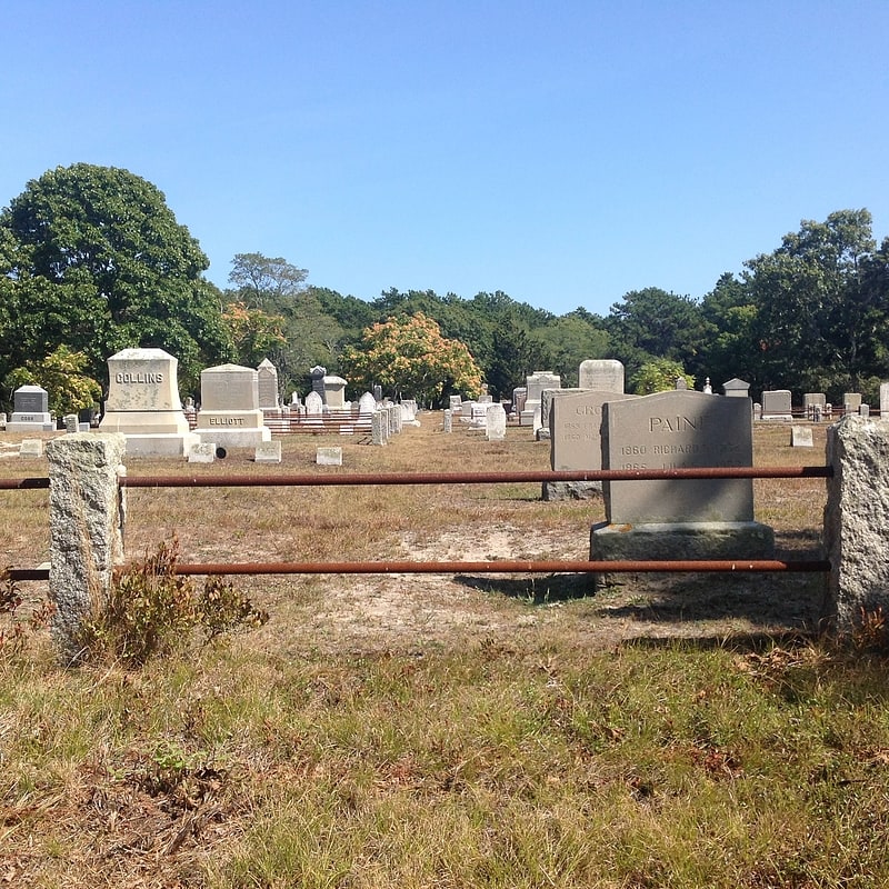
Cemetery in Truro, Massachusetts. The Pine Grove Cemetery is the second oldest cemetery in Truro, Massachusetts. The cemetery was established in 1799; it is located on Cemetery Road in a remote area of the Cape Cod National Seashore. Originally established by Truro's Methodists, the cemetery was located near a church which has not survived. The cemetery is surrounded by a fence made of granite posts connected by iron rails. Access to its interior is via a gravel roadway that roughly bisects the property from east to west; there is also a grassy path to a pedestrian gate on the south side. Burials in the cemetery date from 1799 to the recent past.
The cemetery was added to the National Register of Historic Places in 2013.[11]