Discover 11 hidden attractions, cool sights, and unusual things to do in Andrews Forest (United States). Don't miss out on these must-see attractions: Salt Creek Falls, Koosah Falls, and Hogg Rock. Also, be sure to include Hoodoo Butte in your itinerary.
Below, you can find the list of the most amazing places you should visit in Andrews Forest (Oregon).
Table of Contents
Salt Creek Falls
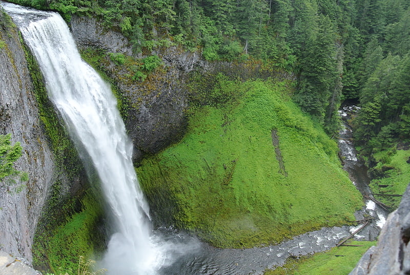
Waterfall in Oregon. Salt Creek Falls is a cascade and plunge waterfall on Salt Creek, a tributary of the Middle Fork Willamette River, that plunges into a gaping canyon near Willamette Pass in the Willamette National Forest, near Oakridge, Oregon. The waterfall is notable for its main drop of 286 feet which makes it the third highest plunge waterfall in Oregon after Multnomah Falls and Watson Falls the second highest, which was re-measured in 2009 and found to be 293 feet rather than an earlier measurement of 272 feet passing Salt Creek Falls. The pool at the bottom of the waterfall is 20 metres deep.[1]
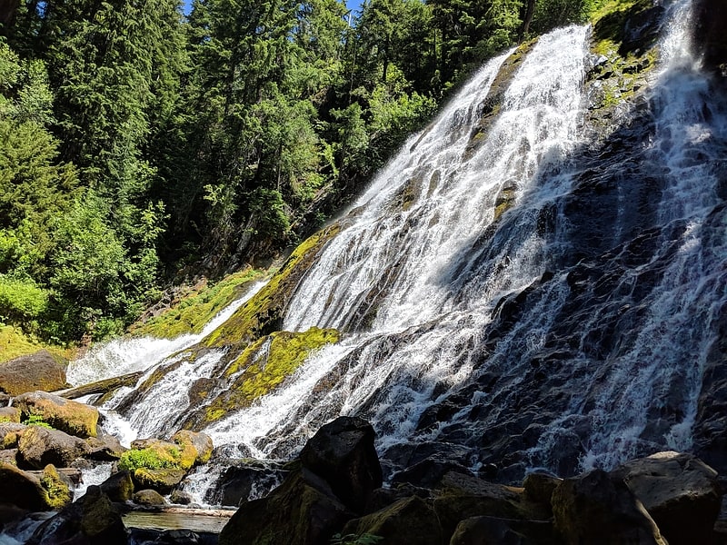
Koosah Falls
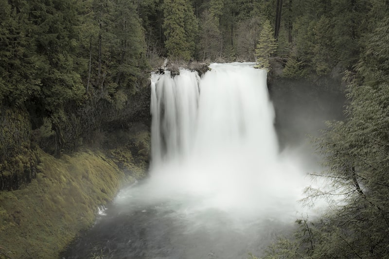
Waterfall in Oregon. Koosah Falls, also known as Middle Falls, is second of the three major waterfalls of the McKenzie River, in the heart of the Willamette National Forest, in Linn County, in the U.S. state of Oregon. The waterfall is notable for its main drop of 64 feet that plunges into a considerable pool, south of Santiam Pass.[2]
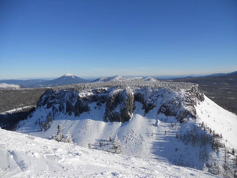
Hogg Rock
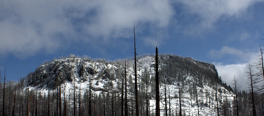
Tuya in Oregon. Hogg Rock is a tuya volcano and lava dome in the Cascade Range of northern Oregon, located close to Santiam Pass. Produced by magma with an intermediate andesite composition, it has steep slopes and thick glassy margins. Hogg Rock exhibits normal magnetic polarity and is probably about 80,000 years old.
Hogg Rock lies south of Three Fingered Jack and north of Hayrick Butte, a somewhat larger tuya of similar age and composition. A tuya is a type of subglacial volcano, formed when lava erupts underneath an overlying glacier or ice sheet and then melts through to the surface and pools, producing the flat plateau on top with near-vertical walls along the ice-contact margin as the lava cools and hardens. It is a historic landmark, with the remnants of Colonel T. Egenton Hogg's Oregon Pacific Railroad, the Santiam Lodge, and a quarry. The mountain offers snowshoe and snowmobile trails, and its summit provides views of the surrounding area including volcanoes like the Black Butte stratovolcano, Mount Washington, Sand Mountain, and Potato Hill.[3]
Hoodoo Butte
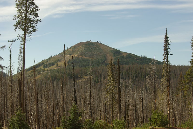
Mountain in Oregon. Hoodoo Butte is a cinder cone butte in the Cascade Range of northern Oregon, located near Santiam Pass. Immediately to the east lies Hayrick Butte, a prime example of a tuya; the two mountains' names were likely mistaken for each other, but stuck with them over time. The area has been subjected to a number of historic fires. Hoodoo is sometimes considered a subfeature of the Mount Washington shield volcano, and it forms part of the Sisters Reach, which extends from South Cinder Peak to Crane Prairie Reservoir, running for 56 miles. This region has a high vent density, with many mafic volcanoes of Pleistocene to Holocene age, such as Hoodoo. While Hoodoo has an intact summit crater that was blocked from erosion by glaciers, it has an irregular topography, giving it an open appearance.
A ski area, also named Hoodoo, is located on the northwest through northeast flanks of the cone, and includes five chairlifts. Other recreational activities popular in the area include snowshoeing and snowmobiling during the winter, and fishing, hiking, camping, mountain biking, windsurfing, and water skiing popular during the summer season.[4]
Tamolitch Falls
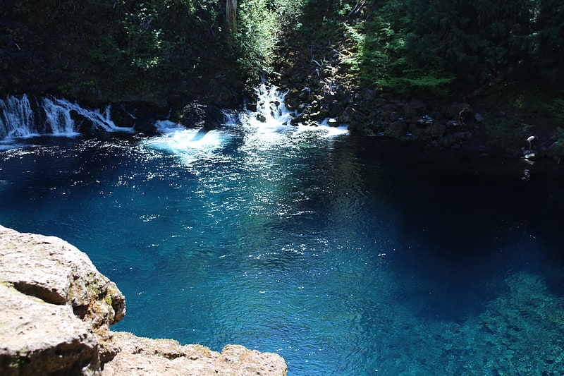
Waterfall in Oregon. The Tamolitch Falls, now a seasonal waterfall, once had a constant flow on the McKenzie River in Lane County, Oregon. The site is located in the Willamette National Forest. In the 1960s, water was diverted for hydroelectric use from the stream above the falls; that section of the stream, as well as the falls, ceased to flow except during periods of heavy runoff or when water was diverted from the dams upstream. When this is not the case, the stream goes underground and now emerges below the falls. At the base of the former falls is the Tamolitch Blue Pool, a small body of water known for its blue color. Elevation: 2,487 feet
The water temperature of the pool is around 38°F which is too cold for even microorganisms to live in. Although the water depth looks to be pretty shallow, the pool is actually 30ft deep.
The pool can be reached from part of the McKenzie River Trail. From the trailhead to the pool, it is a 3.6 mile out and back hike. The trail is heavily trafficked during the spring and summer and parking fills up quickly. The trail welcomes hikers, bikers, runners, and dogs as long as they are on a leash. The beginning of the hike is through an old growth Douglas fir forest. As the McKenzie River flows below, the trail goes up along a cliff which then descends into a dry river bed and from there it eventually goes through an old lava flow. The trail isn’t too strenuous, but it does have an elevation gain of 285ft. The trail also passes by multiple steep cliffs which are hazardous.[5]
Terwilliger Hot Springs
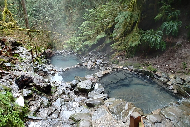
Spring in Oregon. Terwilliger Hot Springs, also known as Cougar Hot Springs, are geothermal pools in the Willamette National Forest in the U.S. state of Oregon, 53 miles east of Eugene. The springs drain into Rider Creek, which in turn drains into Cougar Reservoir. They are about a quarter mile from Forest Service Road 19, also known as Aufderheide Memorial Drive. The hot springs are managed by American Land & Leisure.
Visitors over the years built up four pools out of river stones. The pools' sizes range from 3 to 12 feet (0.9 to 3.7 m) across and 2 to 3 feet (0.6 to 0.9 m) deep. The water source is above the topmost pool where the spring flows from a rock face at approximately 112 °F (44 °C). The pools are on a hillside and cascade from one to the next so that each pool step lower is cooler than the one above it. The pool floors are mostly bedrock but some gravel, sand and debris remain at the bottom of the pools. The pools are closed Thursday mornings for weekly cleaning by the concessionaire.
The pools were renovated in 2009. A group of volunteers, led by a Eugene-based stonemason, removed concrete and built pools using a natural mortar. The new walls will be more stable and easier for volunteers to clean. The renovated pools, the construction of which cost an estimated $40,000, are expected to last for generations.
Access to the springs is subject to a fee. Since 2012, the rates have been $6 per person per day or $60 per person for a seasonal pass to visit. Clothing in the bathing areas is optional, and access is permitted for day use only. Pets are not allowed at the pools, but there is a designated area before the pools where pets can be tied up.
On December 21, 2017 a landslide blocked the road that provides access to the hot springs from the north. The road will be closed indefinitely. At the time, southern access was blocked by winter road conditions and construction, making the hot springs inaccessible to the public.
On August 19, 2018 a fire was reported in the area near Terwilliger Hot Springs. The fire damaged the trail to the springs and the surrounding area. The hot springs were re-opened on July 1, 2019.[6]
Diamond Creek Falls
Scenic spot in Crescent, Oregon. Diamond Creek Falls is a waterfall formed along Gibson Canyon on the north end of Willamette National Forest, east side of the city of Oakridge in Lane County, Oregon. Access to Diamond Creek Falls is located along Oregon Route 58 through trail paths that lead down to the stream and the base of the waterfall.[7]
Clear Lake
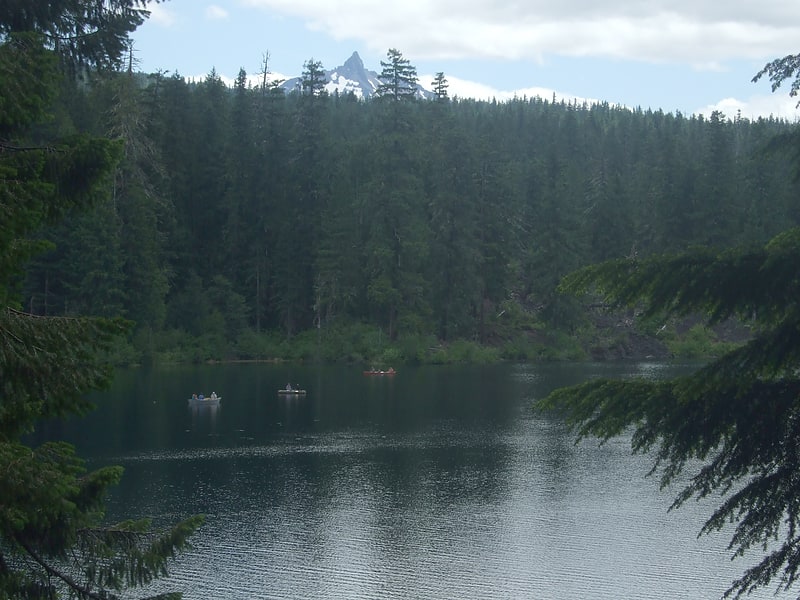
Lake in Oregon. Clear Lake is a mountain lake 86 mi northeast of Eugene, Oregon, United States in Linn County. It has two main bodies connected by a bottleneck. The lake is primarily fed by snow runoff from nearby Mount Washington and the surrounding areas. The runoff filters through caverns for more than 20 years before emptying into Clear Lake. The lake is also fed by two small creeks, which may dry up seasonally, along with Great Spring, the source of the McKenzie River.
Clear Lake is the headwaters of the McKenzie River, which is the sole source of drinking water for Eugene.[8]
Hayrick Butte
Tuya in Oregon. Hayrick Butte is a tuya, a type of subglacial volcano, in Linn County, Oregon. Located in the Willamette National Forest near Santiam Pass, it lies adjacent to the cinder cone Hoodoo Butte, which has a ski area. Hayrick Butte likely formed when lava erupted underneath an overlying glacier or ice sheet, producing the flat top with near-vertical walls along the ice-contact margin as the lava cooled and hardened. Hayrick Butte has a nearly flat plateau about 0.5 miles across and steep walls rising about 700 feet above its surroundings. A cartographer accidentally switched the names for nearby Hoodoo Butte and Hayrick Butte; the word "hoodoo" usually refers to rock piles and pinnacles like those observed at Hayrick Butte.
Compared to Hoodoo, Hayrick is less popular for recreation, though it can be climbed, and there are hiking, snowshoeing, and snowmobile routes surrounding the butte. Its north-facing slope has subalpine forests with mountain hemlock and fir, which are common in the Cascades.[9]
Cougar Reservoir
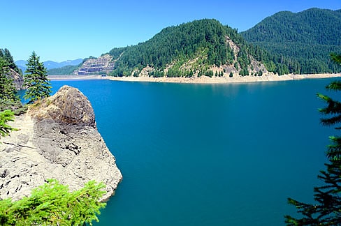
Reservoir in Oregon. Cougar Reservoir is a reservoir on the South Fork McKenzie River in the U.S. state of Oregon. It is in Lane County, 46 miles east of Eugene and about 3 miles south of the community of Rainbow in the Willamette National Forest. In 1963 the United States Army Corps of Engineers built Cougar Dam on the river primarily to generate hydroelectricity and control flooding, and the reservoir formed behind the dam.
The lake is also used for recreation, including boating, fishing, swimming, and waterskiing. The United States Forest Service maintains three campgrounds—Cougar Crossing, Slide Creek, and Sunnyside—near the reservoir, with opportunities for hiking and picnicking as well as camping. Other campgrounds in the general vicinity include French Pete and Delta. Terwilliger Hot Springs is along Rider Creek just west of the lake.
Cougar Reservoir supports populations of stocked rainbow trout and stocked landlocked Chinook salmon as well as naturally reproducing cutthroat trout. Fishing for rainbow trout, especially in winter, is said to be "fair". The lake also supports bull trout, but it is not legal to catch and keep them.[10]
Belknap Bridge
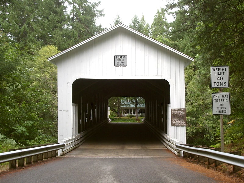
Bridge in Lane County, Oregon. The Belknap Bridge crosses the McKenzie River near the unincorporated community of Rainbow in Lane County, Oregon, United States. It is approximately three miles west of the town of McKenzie Bridge which is named after the bridge. It is the fourth covered bridge built on the site. The bridge is well maintained and open to traffic. The Belknap Bridge is listed on the National Register of Historic Places.[11]