Discover 8 hidden attractions, cool sights, and unusual things to do in Saint George (Bermuda). Don't miss out on these must-see attractions: Fort St. Catherine, St. Peter's Church, and State House. Also, be sure to include Historic Town of St George and Related Fortifications in your itinerary.
Below, you can find the list of the most amazing places you should visit in Saint George (Saint George municipality).
Table of Contents
Fort St. Catherine
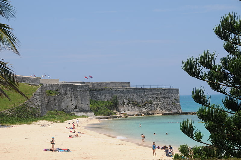
Museum in Bermuda. Fort St. Catherine, or Fort St. Catherine's, is a coastal artillery fort at the North-East tip of St. George's Island, in the Imperial fortress colony of Bermuda. Successively redeveloped, the fort was used first by Bermudian Militia and then by regular Royal Artillery units from 1612 into the 20th century. Today it houses a museum.[1]
Address: 15 Coot Pond Road, GE 03 St. George
St. Peter's Church
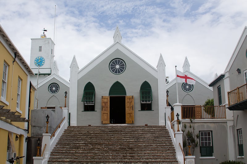
Their Majesties Chappell, St. Peter's Church, in St. George's, Bermuda, is the oldest surviving Anglican church in continuous use outside the British Isles. It is also reportedly the oldest continuously used Protestant church in the New World. A UNESCO World Heritage Site, St. George's Town is the oldest surviving English settlement in the New World, having been settled by the Virginia Company in 1612.[2]
Address: Duke of York St., Saint George
State House
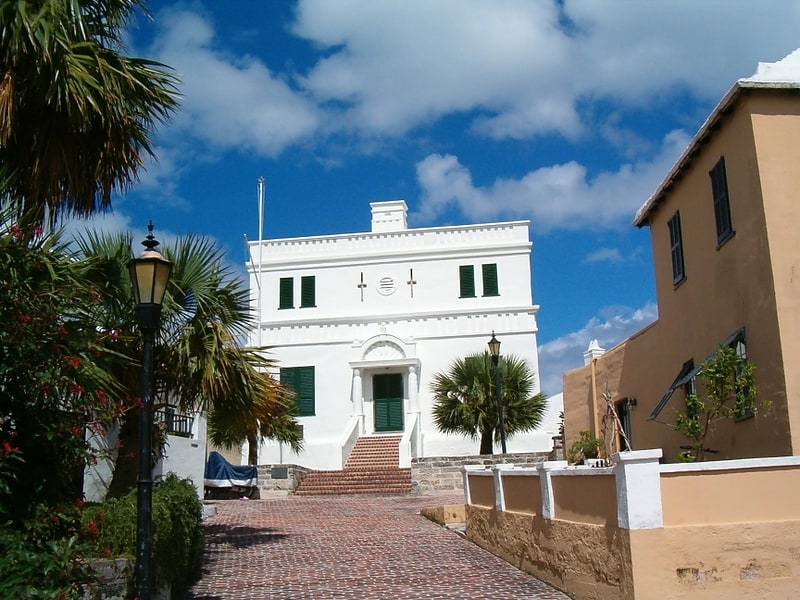
The State House in St. George's was the first purpose-built home of the House of Assembly, which then constituted the only chamber of the Parliament of Bermuda. Other than fortifications, it was Bermuda's first stone building. It is the oldest surviving Bermudian building, again excepting some fortifications, and has been used since 1815 as a Masonic lodge.
Bermuda was settled, unintentionally, in 1609, by the Virginia Company, when its flagship Sea Venture was driven onto the reefs off St. George's Island to prevent her foundering. The survivors, 150 human settlers and crew members and one dog, spent most of the next year on St. George's, before most resumed their voyage to Jamestown, Virginia in two newly constructed ships Deliverance and Patience. The archipelago was officially settled in 1612, when the Virginia Company's Third Charter extended the boundaries of Virginia far enough across the Atlantic to include Bermuda. Settlers and Governor Richard Moore arrived that year aboard Plough to join the three men left behind in 1610. After a brief period on neighbouring Smith's Island, where they found the original three, the settlers moved to St. George's where they founded the town of New London (soon renamed St. George's, like the island). The Virginia Company created a system of government that included the appointed Governor and an elected House Assembly, which held its first session in 1620 (the first assembly having been created in 1619). With no premises of its own, the House of Assembly originally met in St. Peter's Church (the oldest Anglican church outside of the British Isles, having originally been built in 1612, though storms required it to be subsequently rebuilt on several occasions). A purpose-built home was created for the House of Assembly in 1620.
The State House was built along Italian lines, due, reportedly, to then-Governor Nathaniel Butler's conviction that Bermuda shared the same latitude and climate. In fact, Bermuda's Oceanic climate features drastically more rainfall than the Mediterranean climate, and the State House's flat roof proved to be a problem, with many years being spent solving the tendency of water to pool on, and seep through, its porous limestone. The State House was Bermuda's first stone building (other than the open walls of fortifications), but subsequent Bermudian buildings did not follow its design; what became typical Bermudian architecture incorporated stone walls, topped with angled, slate roofs, all made from the local limestone sandstone. The angled roofs were used as a water catchment, and directed the rainfall into gutters leading to tanks, or cisterns.
The State House housed Bermuda's Parliament from 1620 until 1815, when the capital was relocated to the City of Hamilton. Since then, the State House has been leased to the brethren of Lodge St. George No. 200 G.R.S. The token annual rent paid to the Government for the property is one peppercorn. The payment of this peppercorn has developed into an elaborate ceremony involving the Governor and the military.
The State House was one of the sites (the others mostly being military) illustrated on a map of Bermuda (shown at left) published in The Generall Historie of Virginia, New-England, and the Summer Isles, by Captain John Smith in 1624.[3]
Address: 4 Princess Street, Saint George
Historic Town of St George and Related Fortifications
The Historic Town of St George and Related Fortifications is the name used by the United Nations Educational, Scientific and Cultural Organization's World Heritage Committee to identify collectively as a World Heritage Site St. George's Town, founded in 1612, and a range of fortifications, batteries, and magazines built between 1612 and 1939, the last of which was removed from use in 1953.
St. George's, located on the island, and within the parish of the same names, is the oldest surviving English town in the New World. Originally called New London, it was founded by the Virginia Company and was Bermuda's capital until 1815. It contains many historic buildings, including St. Peter's Church (consecrated in 1612, though the oldest parts of the present structure date to 1620), the oldest Protestant church in the New World, the State House, which had housed the Parliament of Bermuda from 1620 until 1815, and many other historical buildings, including the Tucker House, the Globe Hotel, the Mitchell House, Stuart Lodge, the Old Rectory, the Bridge House, the Carriage House, and the Unfinished Church.[4]
St. George's Island
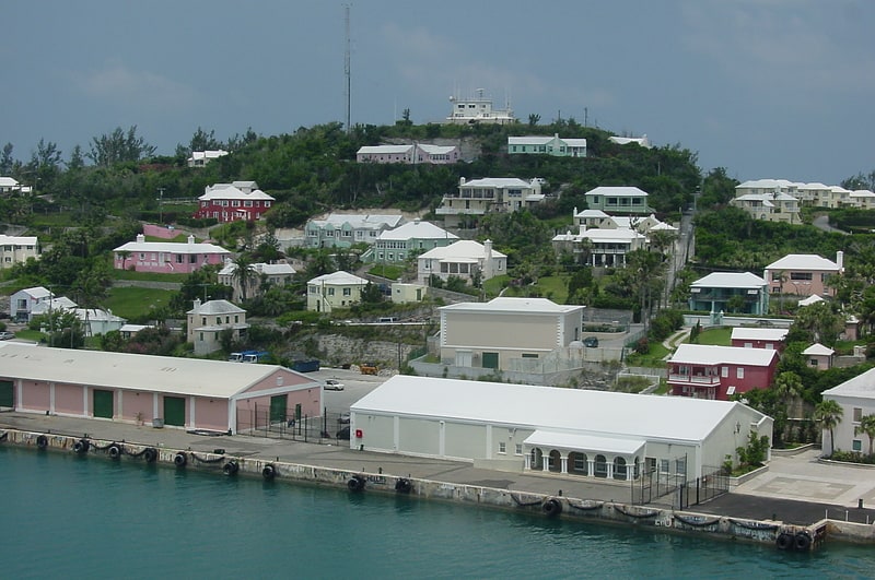
Island in Bermuda. St. George's Island is one of the main islands of the territory of Bermuda and lies within St. George's Parish at the East End of the archipelago. St. George's Town, the original colonial capital, is located on the southern shore near the eastern end of the island. The island covers 703 acres, and is one of the six principal islands of Bermuda.
Originally called King's Island, it was the first part of Bermuda to be extensively colonised, and the town of St. George's contains many of the territory's oldest buildings. Notable among these are St. Peter's Church, and the State House. The island also is the site of the St. George's Garrison and many forts, including Burnt Point Fort, Coney Island Fort, Ferry Point Martello Tower, Gate's Fort, Alexandra Battery, Fort Victoria, Fort Albert, the Western Redoubt, Fort George, and Fort St. Catherine's, the last of which is at St. Catherine's Point, the island's (and the archipelago of Bermuda's) northernmost point, and is a 19th-century construction built upon a 17th-century base. It is beside Gates' Bay, where the first English settlers ship wrecked in the Sea Venture in 1609.
The island is separated from St. David's Island to its south by the St. George's Harbour, and from Coney Island and the Main Island to the south-west by a channel known as Ferry Reach. Bridges and a causeway connect it with the main island via St. David's Island.
The island is nearly split in two by the deep indentation of Mullet Bay, with the western part of the island connected to the rest by a narrow isthmus.[5]
St. George's Harbour
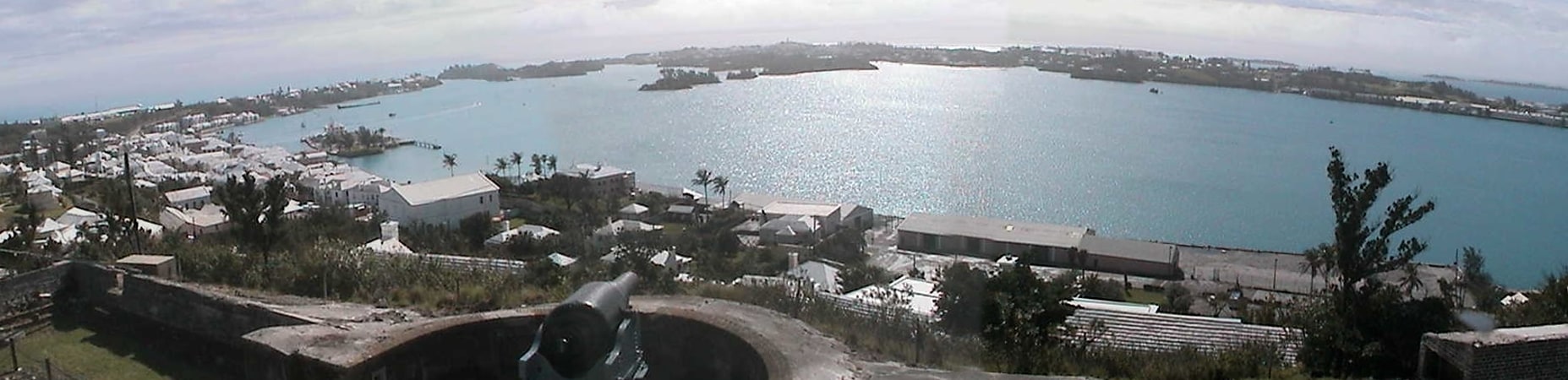
St. George's Harbour is a natural harbour in the north of Bermuda. It serves as the port for the town of St. George's, located on St. George's Island, to its north. To its south is St. David's Island. The harbour and both islands lie within St. George's Parish. It was for two centuries the primary harbour of the British Overseas Territory.[6]
Fort Victoria
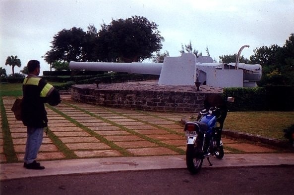
Historical place in Bermuda. Fort Victoria is a disused British Army fort, built to house coastal artillery atop Retreat Hill, within St. George's Garrison, at the North-East of St. George's Island, in the British colony of Bermuda.
The fort shares its hilltop location with Fort Albert, and the pair were named after Her Majesty Queen Victoria and her husband, Prince Albert. Both forts were built in 1842, on the suggestion of Colonel Edward Fanshawe, Royal Engineers, as part of the Bermuda Garrison built up by the British Army to defend the Royal Naval Dockyard and other strategic assets in Bermuda. The only channel through the reefline surrounding the archipelago that is suitable for large vessels passes the North-East ends of St. David's and St. George's Islands, which are at the East End of the archipelago of Bermuda. For this reason, the bulk of the nearly a hundred forts and gun batteries built in Bermuda between 1612 and 1939 are located on the eastern coasts of these two islands, and on Paget Island and the Castle Islands Fortifications, on smaller islands between St. George's and St. David's, and St. David's and the Main Island respectively.
Forts Victoria and Albert overlook Fort St. Catherine's, on the headland below. Fort Victoria is landward of Fort Albert. On the coast to the East is Alexandra Battery. All four of these defence works were placed to fire on enemy ships attempting to enter the Northern Lagoon via Hurd's Channel (also known as The Narrows). On hill tops to the south and southwestward of Retreat Hill, the Western Redoubt (also known as Fort William) and Fort George were built to watch over St. George's Harbour and to defend the forts on Retreat Hill and St. Catherine's Point from attack from the rear. The entire North-Eastern end of the island served as St. George's Garrison, the army base that was initially the headquarters for the Bermuda Garrison. After the infantry component of the garrison and the headquarters were moved to Prospect Camp in the 1860s, St. George's Garrison became primarily a Royal Artillery base, serving the various coastal artillery detachments in the East End forts and batteries.
Fort Victoria was originally armed with eighteen 32 pounder cannon. As with many forts built in this period, the armament was already becoming obsolete by the time it was completed. In the 20th century, the fort was given two Breech-Loading 9.2 inch gun Mk X (although one appears to have been moved to St. David's Battery on St. David's Island, which received two in 1910).
In April 1941 the United States Army Bermuda Garrison was formed under the Destroyers for Bases Agreement enabling the still-neutral United States to aid the British war effort by relieving it of the effort of defending British territory and sealanes in the western North Atlantic. Several military and naval bases were built on Bermuda, and Fort Victoria became the home of some Coast Artillery Corps weapons as part of the Harbor Defenses of Bermuda. These included two 8-inch M1888 railway guns, initially manned by Battery F, 52nd Coast Artillery Regiment (Railway 8-inch gun). Another pair of these guns was at Scaur Hill Fort. Four 90 mm Anti Motor Torpedo Boat (AMTB) guns and a pair of 6-inch guns with a casemated magazine between them (called Battery Construction Number 284) were also installed by 1943. The railway guns were withdrawn in 1944.
St. George's Garrison, with most of the other remaining Admiralty and War Office land in Bermuda was transferred to the colonial government in 1957. Forts Victoria and Albert were included in property leased to a succession of hotel operators (Holiday Inn, Loew's, and Club Med), which were permitted to damage the structures to create recreational areas for guests, including demolishing the keep of Fort Victoria. The hotel building itself, after years of sitting vacant, was removed by explosives in 2008, which badly damaged Fort Victoria.
The sole 9.2-inch gun that had been remaining at Fort Victoria has now been moved to the Royal Naval Dockyard for installation at the Bermuda Maritime Museum in The Keep, the largest fort in Bermuda.
As a result of their historical significance, with fortifications spanning the full four centuries of English settlement in the New World, the forts at the East End of Bermuda, together with St. George's Town (or the Town of St. George), have been made a UNESCO World Heritage Site (the Historic Town of St George and Related Fortifications).[7]
St. David's Island
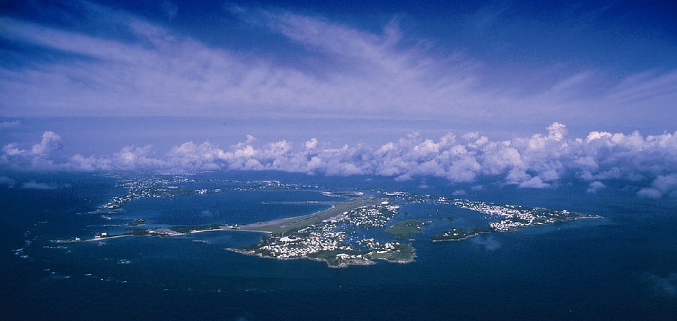
Island in Bermuda. St. David's Island is one of the main islands of the British Overseas Territory of Bermuda. It is located in the far north of the territory, one of the two similarly sized islands that make up the majority of St. George's Parish.
The island was originally 503 acres (2.04 square kilometres) in size. During World War II, in 1942 it was enlarged by reclamation, and by absorbing Long Bird Island and Cooper's Island, to 650 acres (2.63 square kilometres), in order to allow room for a United States military base (originally the US Army's Fort Bell/Kindley Field, operated jointly during the war with the British Royal Air Force). This was later renamed as Kindley Air Force Base and USNAS Bermuda, which occupied more than half the island's land under a 99-year lease.
The base was closed in 1995 and returned to Bermuda. Those parts of the base required for operation of the airfield, along with the Civil air Terminal, became the Bermuda International Airport (subsequently renamed L.F. Wade International Airport by the PLP government). Cooper's Island is now attached physically to southeast St. David's, although the two islands are still widely regarded as if they were separate entities.
The island was named by British colonists in honour of Saint David, the patron saint of Wales, as the similarly sized St. George's Island, to the north, had been named for the patron saint of England. The two islands are separated by two bodies of water - Ferry Reach in the south-west and St. George's Harbor in the north-east. St. David's is separated from the Bermudian mainland by the waters of Castle Harbor in the south, but is joined to it by road via The Causeway.
Notable features of the island include St. David's Head, Bermuda's easternmost point, and the nearby St. David's Battery, on Great Head (Great Head is the more prominent of two headlands that comprise St. David's Head); L.F. Wade International Airport; St. David's Lighthouse; and Annie's Bay on Cooper's Island.
St. David's Island is connected to the United States by an Atlantic fiber optic cable known as 360 Americas.[8]