Discover 20 hidden attractions, cool sights, and unusual things to do in Niagara Falls (United States). Don't miss out on these must-see attractions: Niagara Falls, Horseshoe Falls, and American Falls. Also, be sure to include Cave of the Winds in your itinerary.
Below, you can find the list of the most amazing places you should visit in Niagara Falls (New York).
Table of Contents
Niagara Falls
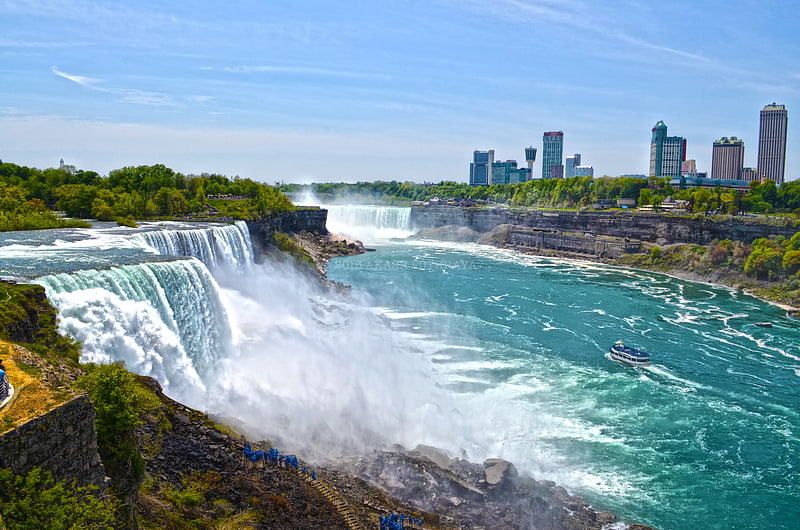
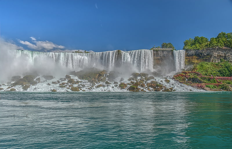
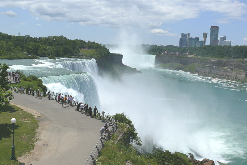
Iconic, monumental group of waterfalls. Niagara Falls is a group of three waterfalls at the southern end of Niagara Gorge, spanning the border between the province of Ontario in Canada and the state of New York in the United States. The largest of the three is Horseshoe Falls, also known as the Canadian Falls, which straddles the international border of the two countries. The smaller American Falls and Bridal Veil Falls lie within the United States. Bridal Veil Falls is separated from Horseshoe Falls by Goat Island and from American Falls by Luna Island, with both islands situated in New York.
Formed by the Niagara River, which drains Lake Erie into Lake Ontario, the combined falls have the highest flow rate of any waterfall in North America that has a vertical drop of more than 50 m (160 ft). During peak daytime tourist hours, more than 168,000 m3 (5.9 million cu ft) of water goes over the crest of the falls every minute. Horseshoe Falls is the most powerful waterfall in North America, as measured by flow rate. Niagara Falls is famed for its beauty and is a valuable source of hydroelectric power. Balancing recreational, commercial, and industrial uses has been a challenge for the stewards of the falls since the 19th century.
Niagara Falls is 27 km (17 mi) northwest of Buffalo, New York, and 69 km (43 mi) southeast of Toronto, between the twin cities of Niagara Falls, Ontario, and Niagara Falls, New York. Niagara Falls was formed when glaciers receded at the end of the Wisconsin glaciation (the last ice age), and water from the newly formed Great Lakes carved a path over and through the Niagara Escarpment en route to the Atlantic Ocean.[1]
Horseshoe Falls
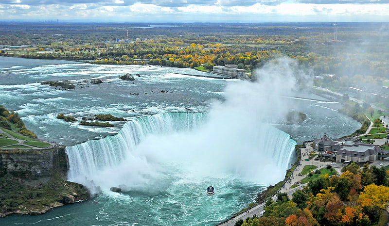
Iconic, monumental waterfall. Horseshoe Falls, also known as Canadian Falls, is the largest of the three waterfalls that collectively form Niagara Falls on the Niagara River along the Canada–United States border. Approximately 90% of the Niagara River, after diversions for hydropower generation, flows over Horseshoe Falls. The remaining 10% flows over American Falls and Bridal Veil Falls. It is located between Terrapin Point on Goat Island in the US state of New York, and Table Rock in the Canadian province of Ontario.[2]
Address: Horseshoe Falls, Niagara Falls
American Falls
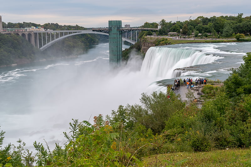
Waterfall in New York State. The American Falls is the second-largest of the three waterfalls that together are known as Niagara Falls on the Niagara River along the Canada–U.S. border. Unlike the much larger Horseshoe Falls, of which approximately 90% is in Ontario, Canada and 10% in the U.S. state of New York, the American Falls is entirely within the United States.[3]
Address: Niagara Falls State Park, 14303 Niagara Falls
Cave of the Winds
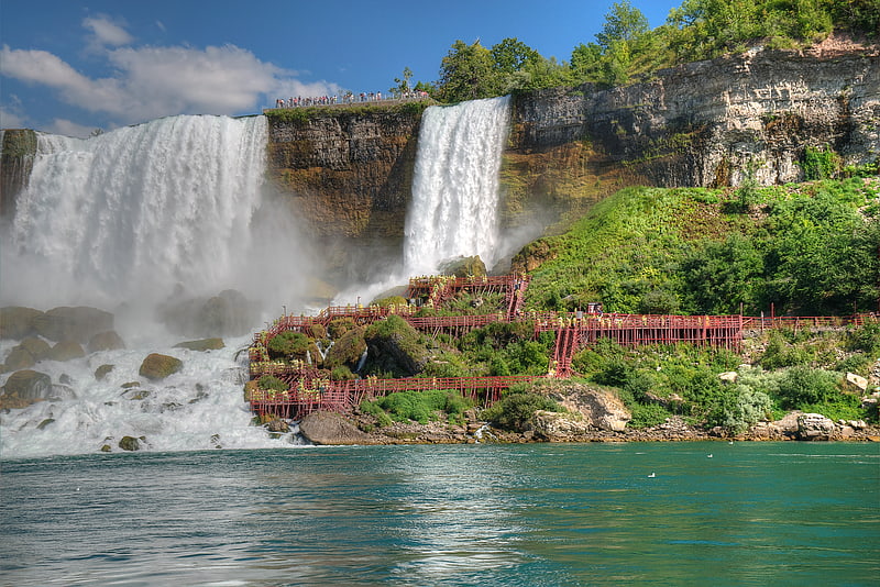
Wooden walkways next to Niagara Falls. The Cave of the Winds was a natural cave behind Bridal Veil Falls at the Niagara Falls. The cave was some 130 feet high, 100 feet wide and 30 feet in depth. It was discovered in 1834, and originally dubbed Aeolus's Cave, after the Greek god of winds.
Guided tours began officially in 1841, through Goat Island and descending down a staircase closer to the falls, into the cave. A rock fall closed the tour in 1920. It officially reopened in 1924, bringing visitors to the front of the Bridal Veil instead of behind it, on a series of decks and walkways. Tropical storm-like conditions can be experienced, as winds can reach up to 68 mph underneath the falls. The cave was obliterated in a massive 1954 rockfall and subsequent dynamiting of a dangerous overhang.[4]
Bridal Veil Falls
Smallest of the 3 Niagara Falls cascades. The Bridal Veil Falls is the smallest of the three waterfalls that make up Niagara Falls. It is located on the American side; Luna Island separates it from the American Falls and Goat Island separates it from the Horseshoe Falls. The Bridal Veil Falls faces to the northwest and has a crest 56 ft wide. Luna Island being very small, the Bridal Veil is similar in appearance to the American Falls, starting with a vertical fall of 78 ft, followed by the water violently descending the talus boulders to the Maid of the Mist pool 103 ft below. The total vertical drop is 181 ft. The crest elevation of the Falls is 508 ft.
The Cave of the Winds attraction allows visitors to walk up to the base of Bridal Veil Falls. A pedestrian bridge crosses from Goat Island to Luna Island several yards upstream from the crest of the falls.
The waterfall has also been known in the past as Luna Falls and Iris Falls.[5]
Address: Niagara Falls, 14303 Niagara Falls
Niagara Falls State Park
City park in Niagara Falls, New York. Niagara Falls State Park is located in the City of Niagara Falls in Niagara County, New York, United States. The park, recognized as the oldest state park in the United States, contains the American Falls, the Bridal Veil Falls, and a portion of the Horseshoe Falls.[6]
Address: 332 Prospect St, Niagara Falls
Love Canal
Neighborhood in Niagara Falls, New York. Love Canal is a neighborhood in Niagara Falls, New York, United States, infamous as the location of a 0.28 km2 landfill that became the site of an enormous environmental disaster in the 1970s. Decades of dumping toxic chemicals harmed the health of hundreds of residents; the area was cleaned up over the course of 21 years in a Superfund operation.
In 1890, Love Canal was created as a model planned community, but was only partially developed. In the 1920s, the canal became a dump site for municipal refuse for the city of Niagara Falls. During the 1940s, the canal was purchased by Hooker Chemical Company, which used the site to dump 19,800 kg (43,700 lb) of chemical byproducts from the manufacturing of dyes, perfumes, and solvents for rubber and synthetic resins.
Love Canal was sold to the local school district in 1953, after the threat of eminent domain. Over the next three decades, it attracted national attention for the public health problems originating from the former dumping of toxic waste on the grounds. This event displaced numerous families, leaving them with longstanding health issues and symptoms of high white blood cell counts and leukemia. Subsequently, the federal government passed the Superfund law. The resulting Superfund cleanup operation demolished the neighborhood, ending in 2004.
In 1988, New York State Department of Health Commissioner David Axelrod called the Love Canal incident a "national symbol of a failure to exercise a sense of concern for future generations". The Love Canal incident was especially significant as a situation where the inhabitants "overflowed into the wastes instead of the other way around". The University at Buffalo Archives house a number of primary documents, photographs, and news clippings pertaining to the Love Canal environmental disaster; many items have been digitised and are viewable online.[7]
Prospect Point Observation Tower
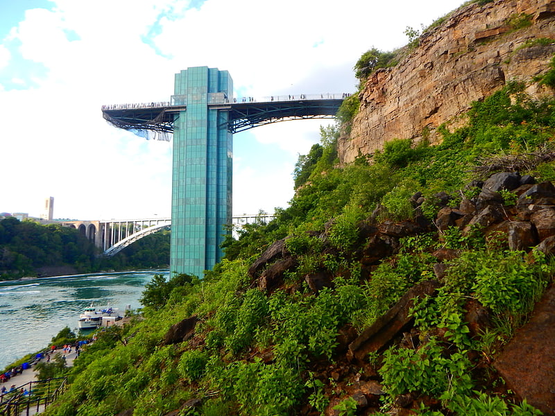
Observation deck above Niagara Falls. The Prospect Point Observation Tower is a tower in Niagara Falls, New York, United States just east of the American Falls.[8]
Address: 333 Prospect St, 14303 Niagara Falls
Aquarium of Niagara
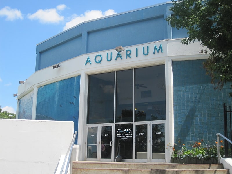
Aquarium in Niagara Falls, New York. The Aquarium of Niagara is a non-profit public aquarium dedicated to education and conservation of aquatic life. Originally privately owned and founded by a group of chemists and other scientists, it opened on June 12, 1965. Ownership was transferred to a non-profit foundation, the Sea Research Foundation, in 1977, and then to the Niagara Aquarium Foundation on February 18, 1994. The Aquarium is located in downtown Niagara Falls, New York, near Niagara Falls State Park. The Aquarium features rescued seals and sea lions, Humboldt penguins, sharks, jellyfish, and over 120 species of fish and invertebrates. The Aquarium of Niagara is accredited by the Association of Zoos and Aquariums.
The Niagara Aquarium Foundation is governed by a Board of Trustees. The Board of Trustees appoints an Executive Director who has immediate charge and control of the administration and operation of the Aquarium. The Aquarium of Niagara is currently under the direction of Gary K. Siddall, who was hired for the role of Executive Director in June 2016.[9]
Address: 701 Whirlpool St, 14301-1094 Niagara Falls
Schoellkopf Power Station
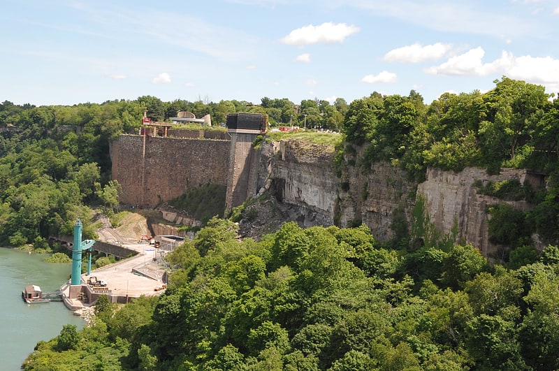
Tourist attraction in Niagara Falls, New York. The Schoellkopf Power Station was built on land owned by Jacob F. Schoellkopf above the Niagara Gorge near the American Falls, 1,600 feet downriver from Rainbow Bridge. Understanding the growing need for electricity and the role of harnessing the Falls, Schoellkopf purchased the land for the hydraulic canal on May 1, 1877 for $71,000. After Schoellkopf Sr.'s death in 1903, his sons took over the operation of the power business. In 1918, Schoellkopf's Niagara Falls Hydraulic Power and Manufacturing Company merged with the Niagara Falls Power Company, which was owned by Edward Dean Adams. Much of the site is, as of 2014, occupied by the Maid of the Mist tour boat company as a maintenance area and off-season boat storage yard. The power station remains form a part of a fully accessible tourist attraction associated with Niagara Falls State Park and is connected with its Niagara Gorge hiking trail system.[10]
Sal Maglie Stadium
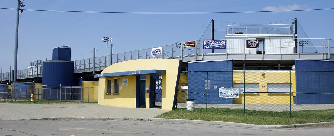
Stadium in Niagara Falls, New York. Sal Maglie Stadium is a stadium in Niagara Falls, New York. It is primarily used for baseball and is currently home of the Niagara Power baseball team.
The ballpark has a capacity of 4,000 people and opened in 1939. Its original name was simply Hyde Park Stadium, and was originally designed primarily for football. It was adapted for baseball in the 1950s and was rebuilt as a proper baseball facility in 1999. In mid-season 1983 it was renamed for Niagara Falls native and former major league player Sal Maglie, who played college ball for Niagara.
Professional clubs occupying the site over the years included the Buffalo Bisons (1967–68), of the International League, as a temporary escape from the deteriorating War Memorial Stadium in Buffalo; the Niagara Falls Pirates (1970–79), later called Niagara Falls Sox (1982–85), Tigers (1989) and Rapids (1989–93), of the New York–Penn League; and Mallards (1995), of the North Atlantic League. The stadium is now home to the Niagara University Purple Eagles Club Baseball team. In the team's first year at the stadium, they won their division title (going 15-2).
Sal Maglie Stadium is located within Hyde Park, on the east side of Hyde Park Boulevard. Robbins Drive bounds the ballpark on the east (right field) side and crosses Gill Creek, which forms the south (first base) boundary of the grounds. Beyond left field are softball and little league diamonds and Linwood Avenue.[11]
Address: 1200 Hyde Park Blvd, Niagara Falls
The Rapids Theatre
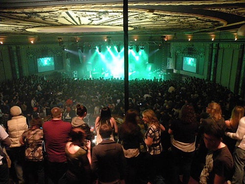
Concert venue in Niagara Falls, New York. The Rapids Theatre is an indoor concert venue and events center situated in downtown Niagara Falls, New York. It hosts a variety of shows and events, including music concerts, comedy acts, wedding receptions, and corporate meetings. Some performances recently held at the Rapids include Passion Pit, Stone Temple Pilots, Pauly Shore, Morrissey, City and Colour, Thirty Seconds to Mars, Snoop Dogg, The Band Perry, Dropkick Murphys, Chevelle, the Headstones, and Eric Church. The venue was also featured on an episode of SyFy's Ghost Hunters that aired on October 19, 2011. The episode was appropriately titled "Stage Fright".
Originally constructed under the name of The Bellevue Theatre in 1921, it opened as a movie theatre and vaudeville stage, complete with a grand balcony and domed ceiling. After a long history of various ownerships and management changes, it most recently reopened as the Rapids Theatre in December 2009 on Main Street, Niagara Falls.[12]
Address: Niagara Falls, 1711 Main Street
Niagara Falls City Hall
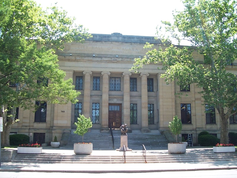
City hall in Niagara Falls, New York. Niagara Falls City Hall is a historic city hall located at Niagara Falls in Niagara County, New York. It was constructed in 1923–1924, in the Beaux-Arts style. The building embodies Neo-Classical Revival architectural details. It features a centrally arranged rectangular form, with a central projecting pavilion, fluted columns with Ionic capitals, and smooth ashlar sandstone walls with pilasters.
It was listed on the National Register of Historic Places in 2001.[13]
Address: 745 Main St, Niagara Falls
Oakwood Cemetery
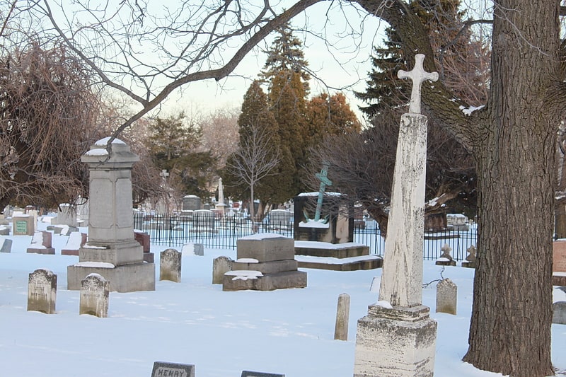
Cemetery in Niagara Falls, New York. Oakwood Cemetery in Niagara Falls, New York was founded in 1852 after land was donated by Lavinia Porter. It covers over 18 acres and over 19,000 are buried there. The cemetery was listed on the National Register of Historic Places in 1984.[14]
Address: 763 Portage Rd, 14301 Niagara Falls
North Grand Island Bridge
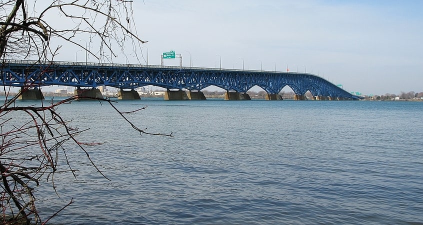
Bridge in Grand Island, New York. The North Grand Island Bridge is a pair of twin two-lane truss arch bridges spanning the Niagara River between Grand Island and Niagara Falls in New York, United States. Each bridge carries one direction of Interstate 190. Both crossings are operated by the New York State Thruway Authority as part of the Niagara Thruway. The northbound span opened in 1935; the southbound span was finished in 1965.
A southbound-only toll is presently collected via open-road cashless tolling. The open-road tolling began operating on March 29, 2018, replacing conventional toll booths which were on Grand Island The tollbooths were dismantled, and drivers are no longer able to pay cash at the bridge. Instead, drivers will travel beneath an overhead gantry where their E-ZPass transponder will be detected and charged. Drivers without an E-ZPass will have a picture of their license plate taken, and the toll will be mailed to them.[15]
Address: NYS Thruway I-190, 14072 Grand Island
Seneca Niagara Casino & Hotel
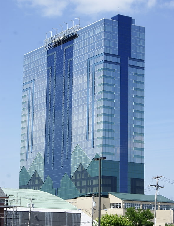
Seneca Niagara Casino & Hotel is a casino in Niagara Falls, New York. It was built by the Seneca Nation to compete with Casino Niagara and Niagara Fallsview Casino Resort in Niagara Falls, Ontario. Formerly known as the Niagara Falls Convention and Civic Center, it was sold to the federally recognized Seneca Nation of New York.
The casino floor has an area of 147,000 sq ft (13,700 m2) with 99 gaming tables and 4,200 slot machines. It is the largest hotel in New York state outside of Manhattan.[16]
Address: 310 4th St, Niagara Falls
First Unitarian Universalist Church of Niagara
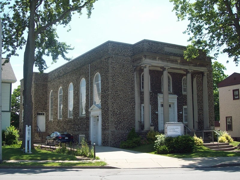
Church in Niagara Falls, New York. First Unitarian Universalist Church of Niagara is a historic church located at Niagara Falls in Niagara County, New York. It was constructed in 1921–1922 in a Classical Revival style. The steel and concrete church is faced with rough, uncut limestone from the bedrock excavated for the building's foundation.
It was listed on the National Register of Historic Places in 2007.[17]
International Control Dam
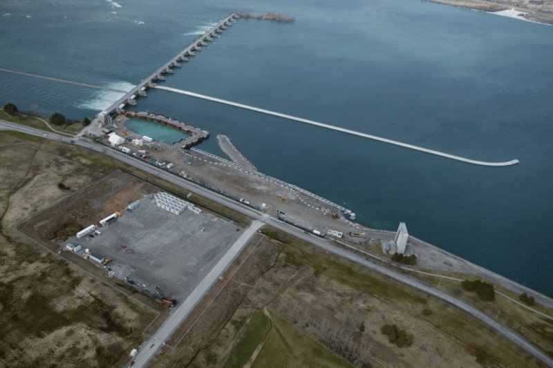
Weir in Niagara Falls, Ontario. The International Control Dam, also known as the International Control Structure, operated by Ontario Power Generation, is a weir that controls the water diversions from the Niagara River and dispatches the water between the New York Power Authority and Ontario Power Generation in accordance with the terms of the 1950 Niagara Treaty. It was completed in 1954.
To preserve Niagara Falls' natural beauty and to ensure an "unbroken curtain of water" is flowing over the falls, the 1950 treaty was signed by the U.S. and Canada to limit water usage by power plants.
The treaty allows higher summertime diversion at night when tourists are fewer and during the winter months when there are even fewer tourists. The treaty states that during daylight time during the tourist season there must be 100,000 cubic feet per second of water flowing over the falls, and during the night and off-tourist season there must be 50,000 cubic feet per second of water flowing over the falls. This treaty is monitored by the International Niagara Board of Control, part of the International Joint Commission, using a NOAA gauging station above the falls.
This weir allows water from the upper river to be diverted into the intakes for the American and Canadian power stations. Two tunnels on the American side take water under the city of Niagara Falls, New York and three tunnels on the Canadian side divert water under the city of Niagara Falls, Ontario. Once past these cities, the water flows into two canals and then into two large reservoirs. Behind the Canadian Sir Adam Beck Power Station is a reservoir covering 300 hectares and a similar reservoir on the US side behind the Robert Moses Power Plant.
A trade off exists between the two main industries of Tourism and Hydroelectric Power. More water is diverted by the International Control Dam at night, between 10:00 pm and 7:00 am, filling the reservoirs over night, and allowing more water over Niagara Falls in the day-time hours for the tourists. As well, during the winter, from Nov. 1 to March 31, when it is not the tourism season, more water is diverted for electrical power during the whole 24 hour period.
The pool of water located immediately upstream of the International Water Control Dam is named the "Chippawa - Grass Island pool".[18]
St. Peter's Episcopal Church
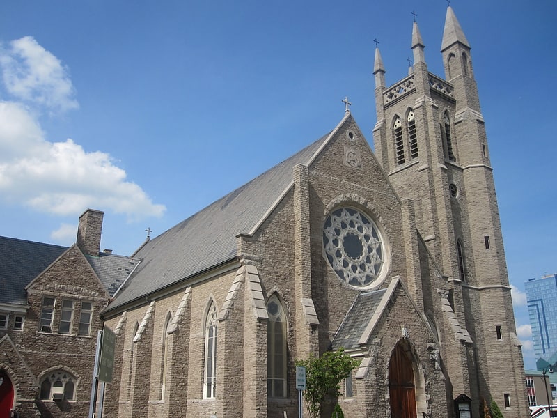
Church in Niagara Falls, New York. St. Peter's Episcopal Church, Niagara Falls, New York, is an Episcopalian church in downtown Niagara Falls, New York.
The first church of the name was built in 1847-49 by George Holley on land given for the purpose from the estate of General Peter Buell Porter; the funeral services of his son Col. Peter A. Porter and other members of his family were held here.
The present church was built in 1873–80 to replace it: the architect was Henry Dudley.[19]
Address: 140 Rainbow Blvd, 14303-1214 Niagara Falls
Mount St. Mary's Hospital
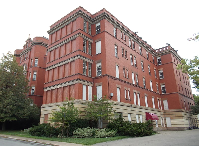
Mount St. Mary's Hospital or St. Mary's Manor is a historic Neoclassical Revival hospital building located at Niagara Falls in Niagara County, New York. It was listed on the National Register of Historic Places in 2015.[20]