Discover 9 hidden attractions, cool sights, and unusual things to do in Mark Twain National Forest (United States). Don't miss out on these must-see attractions: Dillard Mill State Historic Site, Talking Rocks Cavern, and Bell Mountain Wilderness. Also, be sure to include Eleven Point State Park in your itinerary.
Below, you can find the list of the most amazing places you should visit in Mark Twain National Forest (Missouri).
Table of Contents
Dillard Mill State Historic Site
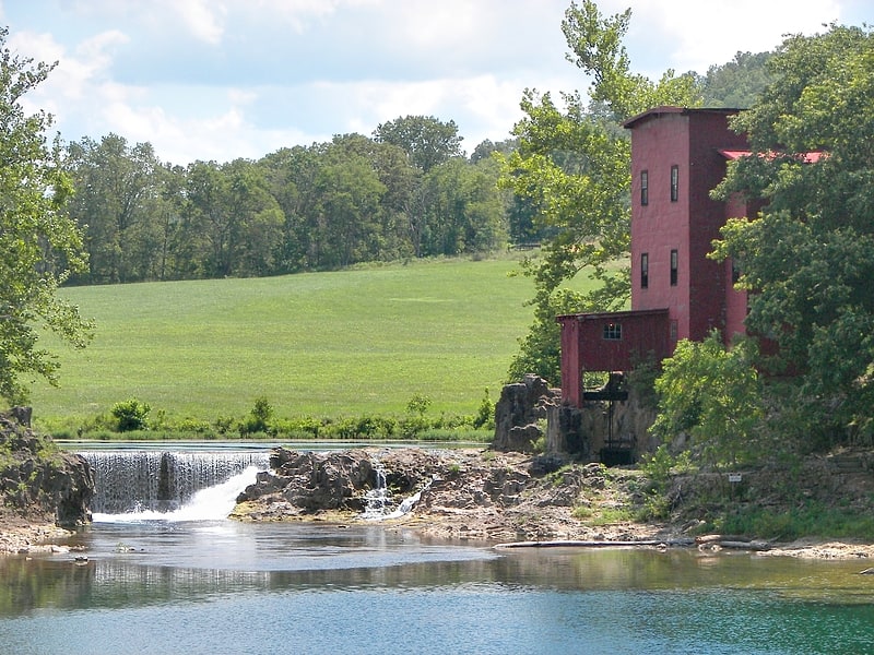
State park in Davisville, Missouri. The Dillard Mill State Historic Site is a privately owned, state-administered property on Huzzah Creek in Crawford County, Missouri, that preserves a water-powered gristmill. The 132-acre site has been operated as a state historic site by the Missouri Department of Natural Resources under a lease agreement with the L-A-D Foundation since 1975. The site was listed on the National Register of Historic Places in 2015.[1]
Address: 142 Dillard Mill Rd, 65456-4014 Davisville
Talking Rocks Cavern
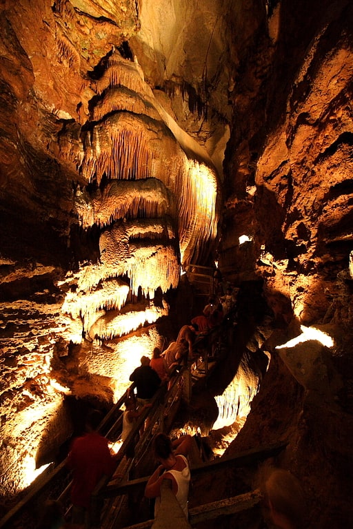
Tourist attraction in Stone County, Missouri. Talking Rocks Cavern is a cavern system located in Stone County, just west of Reeds Spring, in Branson West, in the U.S. state of Missouri. It is privately owned by Herschend Family Entertainment, and operated by Adventure Creations Inc. as a public entertainment/educational attraction.
Guided cave tours are offered at regular intervals throughout each day. Tours take approximately one hour and lead to the floor of the cave, by way of 150 steps going down and 115 steps coming up. There are numerous formations to be viewed up close, including "cave bacon", "curtain", stalagmites, and stalactites. The vertical nature of the cave allows the growth of a formation called "The Cathedral", which is a flowstone and drapery mineral deposit that is approximately 90' tall, and 50' in diameter. The temperature in the cave remains an average 63 degrees throughout the year.
The entrance to the cave is accessed through an entrance inside the Rock and Gift Shop. As there is no outside access, there are no bats living in this cave. There are other living creatures that typically are found in caves, including cave salamanders. Talking Rocks Cavern is considered a living cave, because with the presence of water, the formations continue to grow.
During extremely rainy weather, the cave may be wetter than usual. It rarely floods or interrupts tours.
There are many activities offered at this property, some of them are free. There is an indoor and an outdoor SpeleoBox crawl maze that simulates crawling through a cave. There is a modern children's play area, featuring a large tube slide. There is an oversized outdoor Checkerboard. A 9-hole miniature golf course is available and gemstone sluicing is popular, as well as two nature trails that lead to a 100' lookout tower that offers a panoramic view of the Ozark countryside. The Rock and Gift Shop offers a wide variety of gemstones, fossils, and gift items.
School and Church groups are offered a group rate, and can choose to participate in a SpeleoLab - a cave science program.
Talking Rocks Cavern is open year-round - closing only on Thanksgiving Day and Christmas Day. When inclement weather creates hazardous roads in the area, the cave may close for safety purposes.[2]
Address: 423 Fairy Cave Ln, 65737-8363 Branson West
Bell Mountain Wilderness
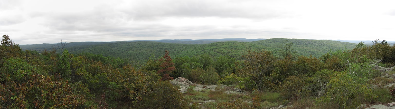
National forest in Belleview, Missouri. The United States Congress designated the Bell Mountain Wilderness in 1980. The wilderness area now has a total of 9,027 acres. Bell Mountain is located within the Potosi-Fredericktown Ranger District of the Mark Twain National Forest, south of Potosi, Missouri in the United States. The wilderness lies in the Saint Francois Mountains and it was named after its highest point, Bell Mountain. The namesake Bell Mountain has the name of Henry Bell, a pioneer settler. The Bell Mountain Wilderness is one of eight wilderness areas protected and preserved in Missouri. The area is popular for hiking as there are 12 miles of trail, including a section of the Ozark Trail.
Bell Mountain Wilderness is part of a large parks-and-wilderness area which includes Johnson's Shut-Ins State Park, Taum Sauk Mountain State Park, and several conservation areas.[3]
Eleven Point State Park
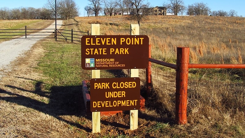
State park. Eleven Point State Park is one of three new Missouri state parks announced in 2016 that is awaiting developments and is unopened. The 4,167 acre state park is located mostly on lands of the historic Pigman Ranch near Riverton in Oregon County on Eleven Point River in the Ozarks of southern Missouri. Plans called for hiking and walking trails, camping, fishing, picnicking, birdwatching, and nature study to be available. In August 2017, the administration of Governor Eric Greitens closed the park indefinitely.[4]
White Cloud Presbyterian Church and Cemetery
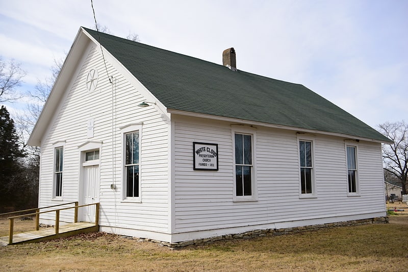
Church in Callaway County, Missouri. White Cloud Presbyterian Church and Cemetery is a historic Presbyterian church and cemetery located at Fulton, Callaway County, Missouri. It was built in 1888, and is a one-story, frame gable front church on a limestone foundation. There are approximately 250 graves in the cemetery dating from about 1840 to the present.
It was listed on the National Register of Historic Places in 2010.[5]
Irish Wilderness
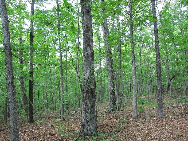
Hiking area in Oregon County, Missouri. The Irish Wilderness is a 16,227-acre wilderness area in the U.S. State of Missouri. The U.S. Congress designated it a wilderness in 1984. The Irish Wilderness is located within the Eleven Point Ranger District of the Mark Twain National Forest, 10 miles northeast of Alton, Missouri. The Irish Wilderness is one of eight wilderness areas protected and preserved in Missouri.
Hiking and horseback riding are popular on the White's Creek Trail, an 18.6 miles trail throughout the wilderness. Attractions include White's Creek Cave (temporarily gated to protect endangered bats), Fiddler and Bliss Springs, traces of old tramway railroads, and overlooks of the Eleven Point River. The karst topography of the area creates very scenic views along this trail. Wildlife present include black bear, mountain lion, whitetail deer, timber rattlesnakes, turkey, and bald eagles.[6]
Black Mountain
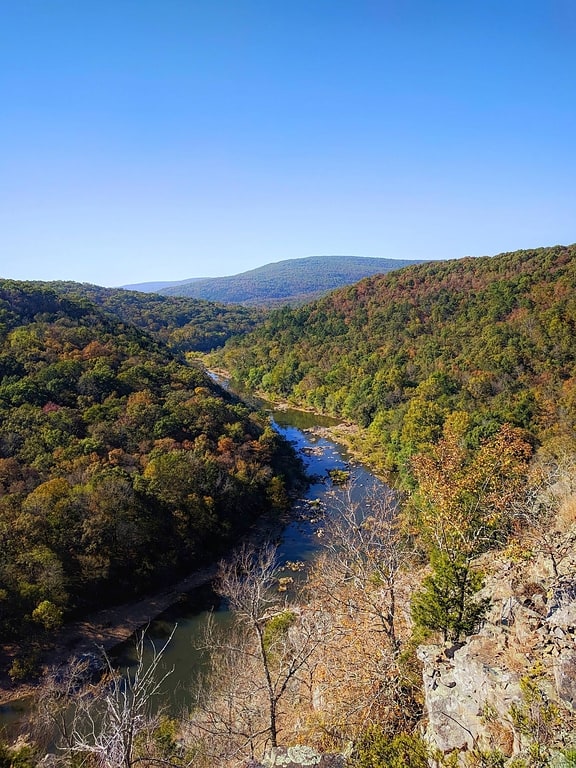
Summit in Missouri. Black Mountain is a summit in western Madison County in the U.S. state of Missouri. The peak has an elevation of 1,503 feet. The St. Francis River flows past the east side of the mountain at an elevation of about 560 feet. Missouri Route E passes the east and south side of the mountain. The community of French Mills lies adjacent to the St. Francis just to the south of the mountain.
Black Mountain has the name of the local Black family.[7]
Lake Wappapello
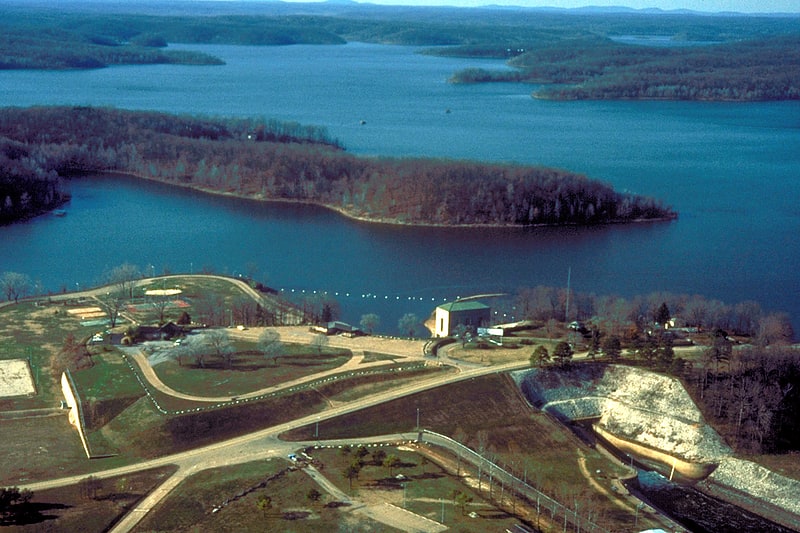
Reservoir in Missouri. Lake Wappapello is a reservoir on the St. Francis River, formed by Wappapello Dam. Created in 1941, this 8,400-acre lake is located 120 miles south of St. Louis, Missouri. The reservoir lies mostly in Wayne County, but its southernmost reaches extend into northern Butler County, both in Missouri. Both the dam and reservoir are owned and operated for the public by the United States Army Corps of Engineers.
Its primary purpose is flood control, although it has been developed as a recreational area with ample opportunities to boat, fish, swim or camp. The fish population of the lake include white bass, largemouth bass, crappie, and bluegill. Lake Wappapello State Park is composed of territory on the southwestern side of the lake.[8]
Bates-Geers House
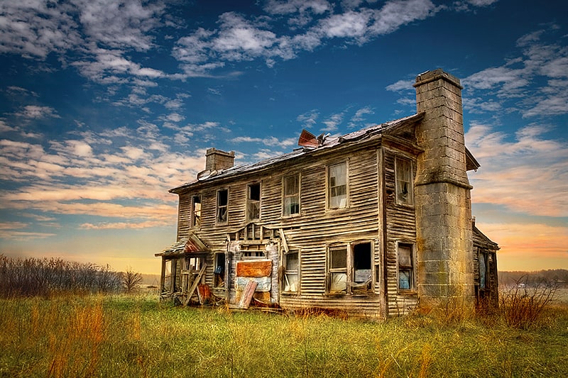
The Bates-Geers House, also known as Geers House, is a historic home located near Plato, Texas County, Missouri. It was built about 1840, and is a two-story, five bay, Greek Revival style frame dwelling with a rear ell. It sits on a sandstone foundation and features massive sandstone end chimneys.
It was listed on the National Register of Historic Places in 1982.[9]