Discover 11 hidden attractions, cool sights, and unusual things to do in Lassen Volcanic National Park (United States). Don't miss out on these must-see attractions: Lassen Peak, Cinder Cone, and Manzanita Lake. Also, be sure to include Lake Helen in your itinerary.
Below, you can find the list of the most amazing places you should visit in Lassen Volcanic National Park (California).
Table of Contents
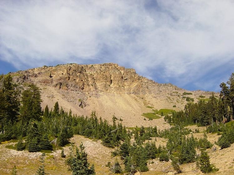
Lassen Peak
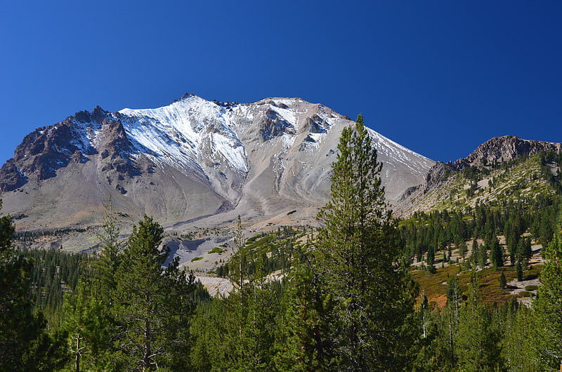
Major volcanic peak with hiking trails. Lassen Peak, commonly referred to as Mount Lassen, is the southernmost active volcano in the Cascade Range of the Western United States. Located in the Shasta Cascade region of Northern California, it is part of the Cascade Volcanic Arc, which stretches from southwestern British Columbia to northern California. Lassen Peak reaches an elevation of 10,457 ft, standing above the northern Sacramento Valley. It supports many flora and fauna among its diverse habitats, which are subject to frequent snowfall and reach high elevations.
A lava dome, Lassen Peak has a volume of 0.6 cu mi (2.5 km3) making it the largest lava dome on Earth. The volcano arose from the former northern flank of now-eroded Mount Tehama about 27,000 years ago, from a series of eruptions over the course of a few years. The mountain has been significantly eroded by glaciers over the last 25,000 years, and is now covered in talus deposits.
On May 22, 1915, a powerful explosive eruption at Lassen Peak devastated nearby areas, and spread volcanic ash as far as 280 mi (450 km) to the east. This explosion was the most powerful in a series of eruptions from 1914 through 1917. Lassen Peak and Mount St. Helens in Washington were the only two volcanoes in the contiguous United States to erupt during the 20th century.
Lassen Volcanic National Park, which encompasses an area of 106,372 acres (430.47 km2), was created to preserve the areas affected by the eruption, for future observation and study, to protect the nearby volcanic features, and to keep away anyone from settling too close to the volcano. The park, along with the nearby Lassen National Forest and Lassen Peak, have become popular destinations for recreational activities, including climbing, hiking, backpacking, snowshoeing, kayaking, and backcountry skiing. Lassen Peak is dormant, meaning the volcano is merely inactive, and it has a functioning magma chamber under the ground still capable of eruptions. Thus it poses a threat to the nearby area through lava flows, pyroclastic flows, lahars (volcanically induced mudslides, landslides, and debris flows), ash, avalanches, and floods. To monitor this threat, Lassen Peak and the surrounding vicinity are closely observed with sensors by the California Volcano Observatory.[1]
Cinder Cone
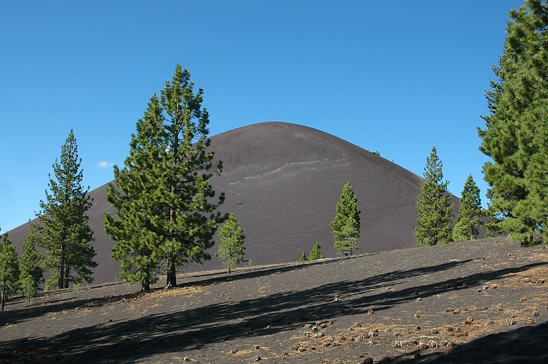
Cinder cone in California. Cinder Cone is a cinder cone volcano in Lassen Volcanic National Park within the United States. It is located about 10 miles northeast of Lassen Peak and provides an excellent view of Brokeoff Mountain, Lassen Peak, and Chaos Crags.
The cone was built to a height of 750 feet (230 m) above the surrounding area and spread ash over 30 square miles (78 km2). Then, like many cinder cones, it was snuffed out when several basalt lava flows erupted from its base. These flows, called the Fantastic Lava Beds, spread northeast and southwest, and dammed creeks, first creating Snag Lake on the south and then Butte Lake to the north. Butte Lake is fed by water from Snag Lake seeping through the lava beds. Nobles Emigrant Trail goes around Snag Lake and follows the edge of the lava beds.
Its age has been controversial since the 1870s, when many people thought it was only a few decades old. Later, the cone and associated lava flows were thought to have formed about 1700 or during a 300-year- long series of eruptions ending in 1851. Recent studies by U.S. Geological Survey (USGS) scientists, working in cooperation with the National Park Service to better understand volcanic hazards in the Lassen area, have firmly established that Cinder Cone was formed during two eruptions that occurred in the 1650s.[2]
Manzanita Lake
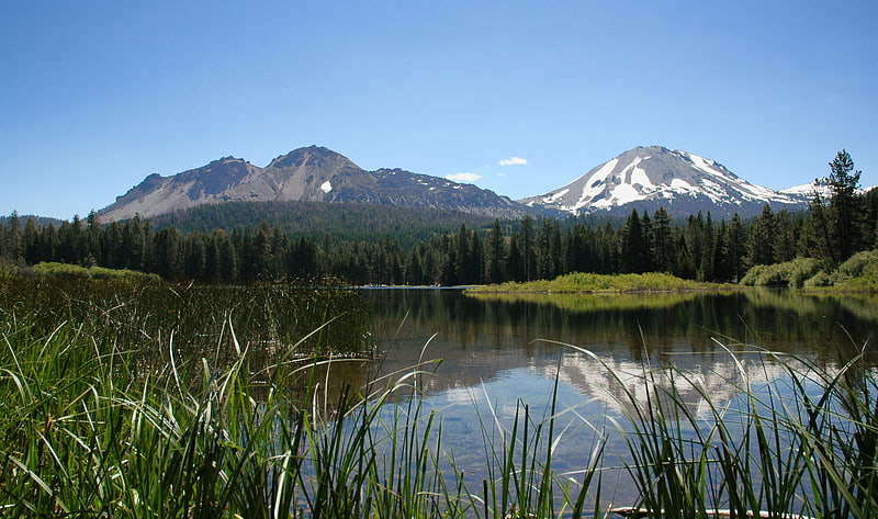
Lake in California. Manzanita Lake is a lake located in Lassen Volcanic National Park. The name means "little apple" in Spanish.
Located near the park entrance, the lake is open for fishing and has rainbow, brown and brook trout.
Manzanita Lake was formed when Manzanita Creek was dammed 300 years ago by a rock avalanche from the northwest slope of the Chaos Crags, which also resulted in the debris formation known as Chaos Jumbles.
The area around the lake features the Loomis Museum, a campground, and the Manzanita Lake Naturalist's Services Historic District.[3]
Lake Helen
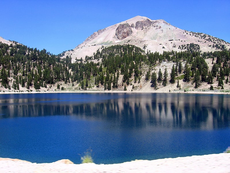
Lake in California. Lake Helen is a glacial lake or a tarn occupying a cirque at around 8,200 feet in Lassen Volcanic National Park. The lake is located to the south of Lassen Peak and west of Bumpass Mountain in the Shasta Cascades region of Northern California. Highway 89 runs along the lake's southern and eastern shore. The lake is named for Helen Tanner Brodt who in 1864 became the first white woman to reach the summit of Lassen Peak.[4]
Mount Tehama
Stratovolcano in California. Mount Tehama is an eroded andesitic stratovolcano in the Cascade Volcanic Arc and the Cascade Range in Northern California. Part of the Lassen volcanic area, its tallest remnant, Brokeoff Mountain, is itself the second highest peak in Lassen Volcanic National Park and connects to the park's highest point, Lassen Peak. Located on the border of Tehama County and Shasta County, Brokeoff's peak is the highest point in the former. The hikers that summit this mountain each year are treated to "exceptional" views of Lassen Peak, the Central Valley of California, and many of the park's other features. On clear days, Mount Shasta can also be seen in the distance.
Brokeoff Volcano was active from 590,000 to 387,000 years ago, during which period it erupted numerous flows with compositions ranging from basaltic andesite to dacite. At its peak, Brokeoff Volcano reached an estimated height of 3,350 meters (11,000 feet) and had a basal circumference of approximately 12 kilometers. At approximately 313,000 years ago volcanism began shifting to the northeast of Brokeoff Volcano, with volcanism currently focused around the modern Lassen Peak. Following the end of volcanism at Brokeoff Volcano, cooling magma beneath the surface continued to drive hot, highly reactive hydrothermal fluids circulating near the central vent of the volcano. These hydrothermal fluids chemically weathered the volcanic rocks near the central vent, making them particularly susceptible to physical erosion. Glaciers and streams were able to rapidly erode the hydrothermally altered rocks near the central vent, creating the deep Mill Canyon and exposing deep into the core of the ancient volcano.
Many of the lava flows along the flanks of Brokeoff Volcano were not as extensively chemically weathered, resulting in the flanks of much of the volcano being preserved. Remnants of the flanks of Brokeoff Volcano include Brokeoff Mountain, Mount Conard, Pilot Pinnacle, Mount Diller, and Diamond Peak.[5]
Loomis Museum
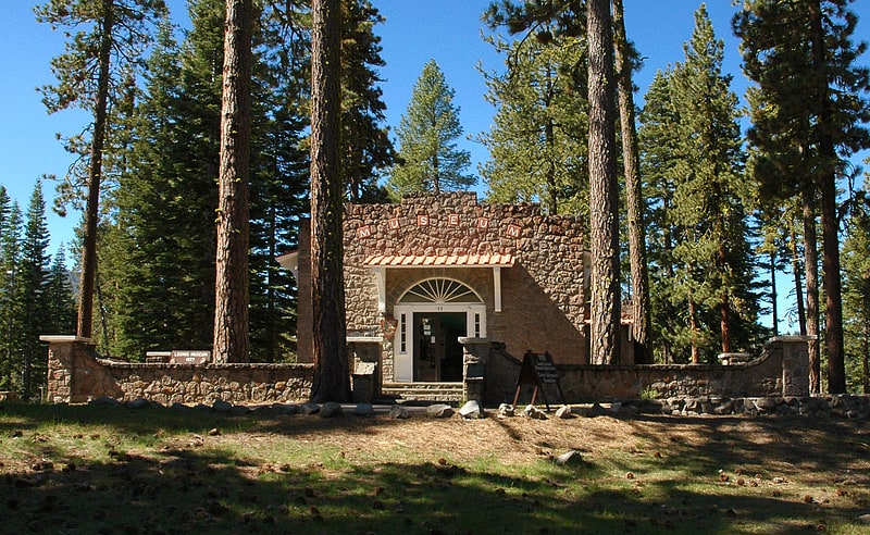
Museum in Shasta County, California. The Loomis Museum, also known as the Loomis Visitor Center, the Manzanita Lake Visitor Center and the Manzanita Lake Museum, was built by Benjamin Franklin Loomis in 1927 near Manzanita Lake, just outside Lassen Volcanic National Park in California, USA. Loomis was a local homesteader and photographer who documented the 1915 eruptions of Lassen Peak, and was instrumental in the 1916 establishment of the national park. In 1929 Loomis donated the museum and 40 acres of surrounding lands to the National Park Service, which since then has used the structure as an interpretational facility.
Loomis had desired that the headquarters of the new park be established at Manzanita Lake, but an alternate site was chosen by the Park Service. Loomis and his wife Estella started building their own museum to exhibit photographs taken by Loomis and others, as well as geological exhibits and artifacts of local Native Americans. The building was dedicated on July 4, 1927 as the Mae Loomis Memorial Museum, named after their only child, Luisa Mae Loomis, who had died in 1920.[6]
Summit Lake
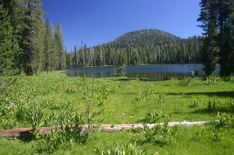
Lake in California. Summit Lake is a lake in the Lassen Volcanic National Park of Shasta County, California, east of California Route 89 at elevation 6,700 ft. Two campgrounds, named Summit Lake North and Summit Lake South, are located adjacent to the lake.[7]
Butte Lake
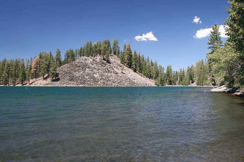
Lake in California. Butte Lake is a lake located in the northeast section of Lassen Volcanic National Park in the U.S. state of California at an elevation of 6,053 ft.[8]
Emerald Lake
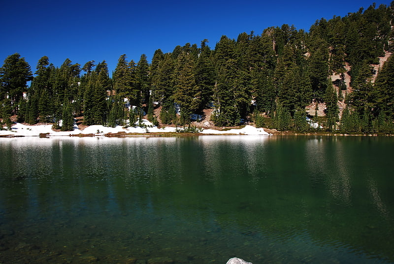
Lake in California. Emerald Lake is a small lake located nearby Lassen Peak in Lassen Volcanic National Park, in Shasta County, California.
The lake is located about 0.3 mi (0.5 km) west of Lake Helen. Highway 89 runs along the eastern shore of the small lake.[9]
Bumpass Mountain
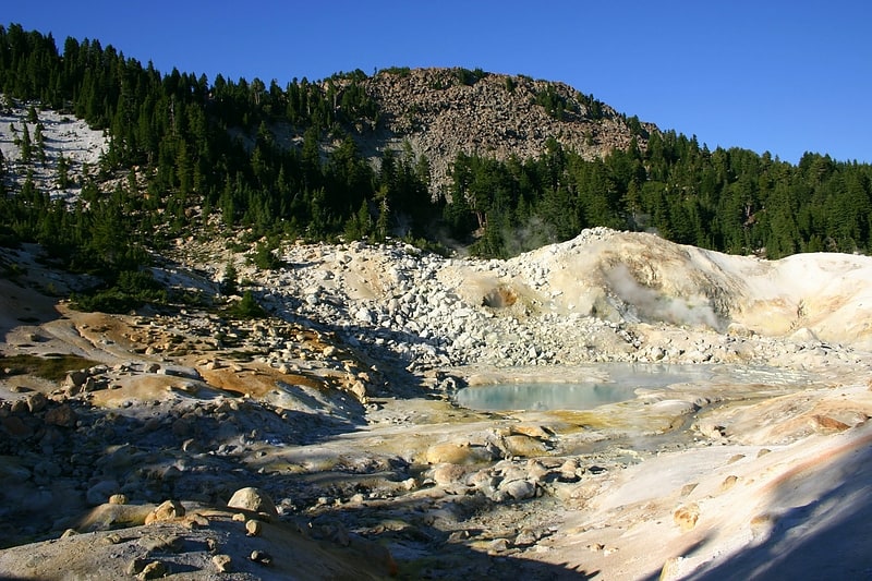
Mountain in California. Bumpass Mountain is a mountain located south of Lassen Peak in Lassen Volcanic National Park, California. It rises to an elevation of 8,753 feet near Bumpass Hell and Lake Helen. The mountain receives heavy snowfall during the winter, which can lead to deep snowpacks of over 300 inches near the mountain.
Both the mountain and Bumpass Hell were named in honor of Kendall V. Bumpass, a hunter, guide and prospector in the area around Red Bluff, California, before 1870.[10]
Mount Harkness Fire Lookout
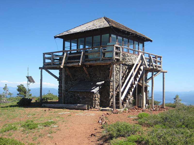
The Mount Harkness Fire Lookout, on Mount Harkness in Lassen Volcanic National Park, in Plumas County, California near Mineral, California, was listed on the National Register of Historic Places in 2017.
It was built in 1931 to a "classic rustic NPS design". It has a 15 by 15 feet (4.6 m × 4.6 m) cab with a log catwalk and railings, upon a 15 feet (4.6 m) stone tower.
It is at elevation 7,985 feet (2,434 m) and is staffed and open during the summer.
It is one of fewer than 40 operating National Park Service (NPS) fire lookouts in 2019.
It was destroyed by the July/August 2021 Dixie Fire.[11]