Discover 15 hidden attractions, cool sights, and unusual things to do in High Peaks Wilderness Area (United States). Don't miss out on these must-see attractions: Mount Marcy, Adirondack High Peaks, and Avalanche Lake. Also, be sure to include Cascade Mountain in your itinerary.
Below, you can find the list of the most amazing places you should visit in High Peaks Wilderness Area (New York).
Table of Contents
Mount Marcy
Mountain in New York State. Mount Marcy is the highest point in New York, with an elevation of 5,344 feet. It is located in the Town of Keene in Essex County. The mountain is in the heart of the Adirondack High Peaks region of the High Peaks Wilderness Area. Its stature and expansive views make it a popular destination for hikers, who crowd its summit in the summer months.
Lake Tear of the Clouds, at the col between Mounts Marcy and Skylight is often cited as the highest source of the Hudson River, via Feldspar Brook and the Opalescent River, even though the main stem of the Opalescent River has as its source a higher point two miles north of Lake of the Clouds, and that stem is a mile longer than Feldspar Brook.[1]
Address: 44°06′45.84″N 73°55′25.41″W, 12942 Keene
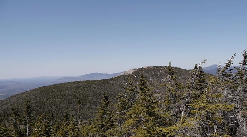
Adirondack High Peaks
The Adirondack High Peaks are a set of 46 mountain peaks in the Adirondack Mountains of New York, United States.[2]
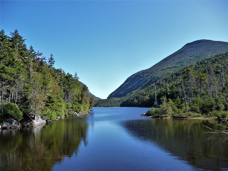
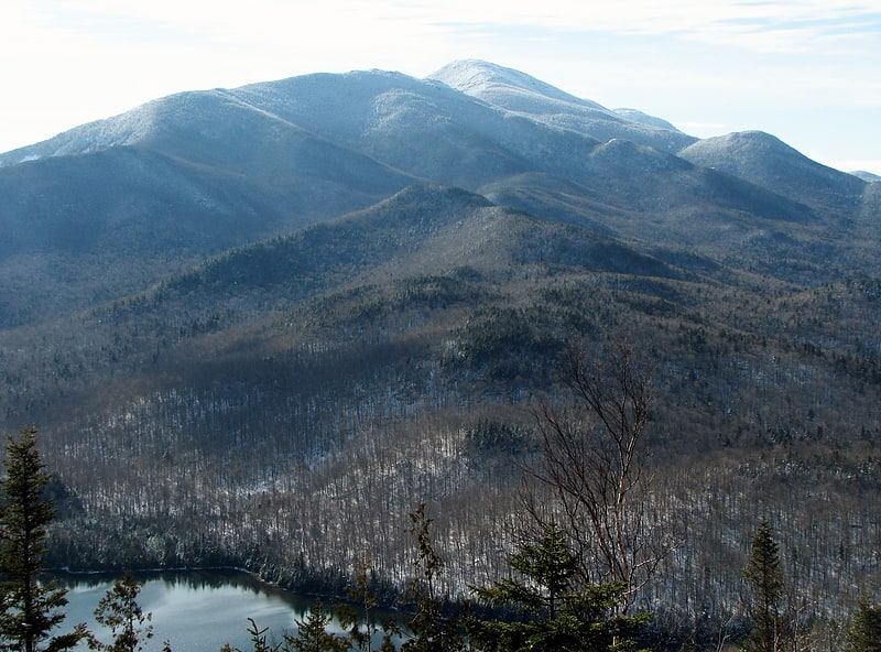
Avalanche Lake
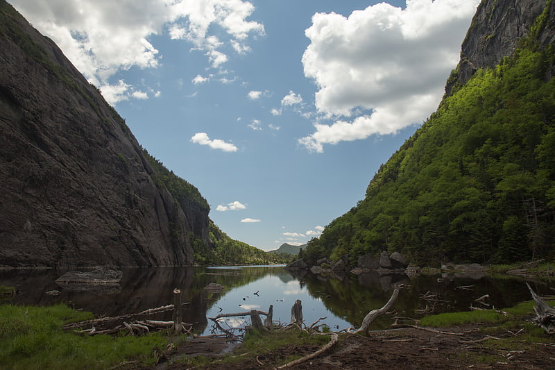
Lake in New York State. Avalanche Lake is a 9-acre mountain lake located in the Adirondack High Peaks in New York. Avalanche Lake sits at 2885 feet between 4,714-foot Mount Colden and-3816 foot Avalanche Mountain. The two mountains rise in vertical cliffs from the surface of the lake. Immediately west of Avalanche Mountain lies the MacIntyre Range— 5,115-foot Algonquin Peak, 4829-foot Boundary Peak, 4,843-foot Iroquois Peak and 4,380-foot Mount Marshall. Mount Marcy is 2.5 miles to the east. Avalanche Lake feeds Lake Colden to the south, in the Hudson River watershed. To the north, the trail to the lake from the Adirondak Loj surmounts Avalanche Pass, which is only slightly above lake level but separates it from the Lake Champlain watershed. Following the lake toward Lake Colden, the trail is choked with large boulders, and a number of wooden ladders have been built to make passage possible. There are also three places where the trail takes to wooden catwalks, first built in the 1920s, that are bolted directly into the cliff face. This section is known as the "Hitch-Up Matilda;" in 1868 when a mountain guide waded to carry one of his clients past a point with no footing on shore, her husband urged her to sit higher on his shoulders.[3]
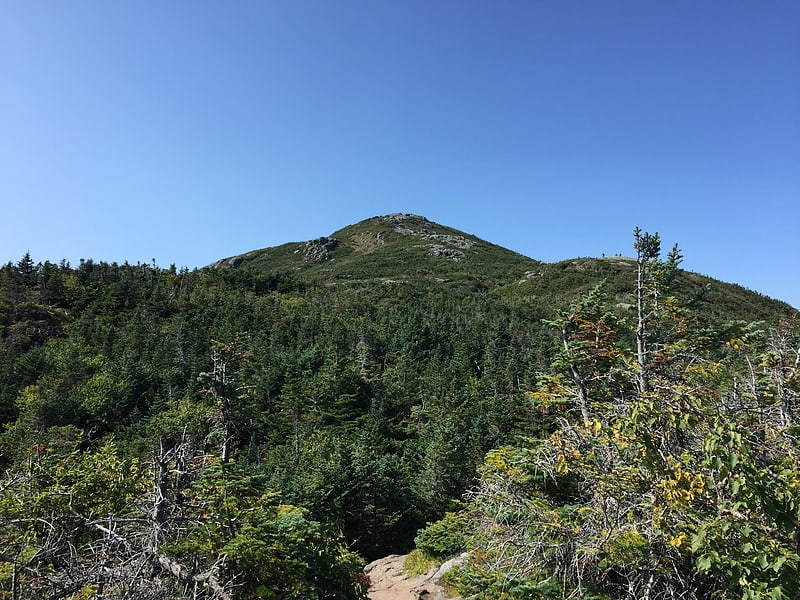
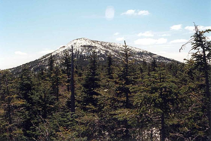
Cascade Mountain
Peak in New York State. Cascade Mountain is in Essex County of New York. It is one of the 46 Adirondack High Peaks and is located in the Adirondack Park. Its name comes from a series of waterfalls on a brook near the mountain's base. The lake it flows into and the pass between Cascade and Pitchoff mountains are also named Cascade.
Cascade Mountain towers over the Van Hoevenberg ski center, the venue for bobsledding at the 1980 Winter Olympics.
Of the 46 Adirondack High Peaks, Cascade is the most accessible and the most frequently climbed. The main trailhead is on Route 73, 6 miles (10 km) east of Lake Placid, at Cascade Pass, overlooking Cascade Lake. The summit is visible from the trailhead, a rare occurrence in the High Peaks.
The well-used trail follows red plastic markers and takes the hiker up 2.2 miles (4.6 km) and almost 2,000 vertical feet (600 vertical m) to the mountain's bare-rock summit, which, while it resembles the alpine summits found on many higher peaks, is instead the result of a 1903 fire.
Views are possible in all directions, and on a clear day with good weather one often finds many hikers on the summit.
Porter Mountain, another of the High Peaks, is an easy side-trip. The summit of Porter Mountains is 0.7 miles from Cascade Mountain Trail. The two summits can be reached together on a 6.2-mile hike.[4]
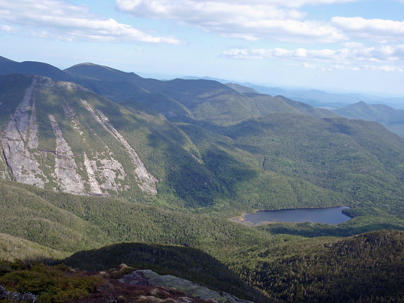
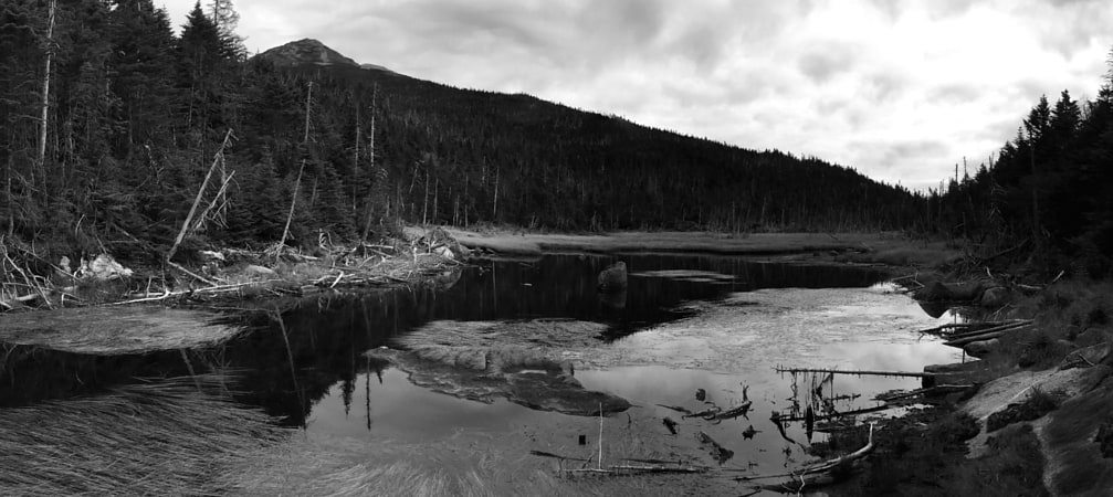
Lake Colden
Lake in New York State. Lake Colden is a 41-acre lake located in the Adirondack High Peaks in New York, United States. Lake Colden sits at 2764 feet at the western base of 4,714-foot Mount Colden. To the northwest lie the MacIntyre Mountains— 5,115-foot Algonquin Peak, 4829-foot Boundary Peak, 4,843-foot Iroquois Peak and 4,380-foot Mount Marshall. Mount Marcy is 2.8 miles to the east. Lake Colden is fed by Avalanche Lake, to the northeast and in turn feeds Flowed Lands, to the southwest.
Being in the heart of the High Peaks, the area is very popular with hikers. The New York State Department of Environmental Conservation maintains an Interior Outpost on the western shore. There are a number of campsites and lean-tos in the area.
Lake Colden was named after David C. Colden in 1836; Colden was an investor in the Tahawus iron works of Archibald MacIntyre.[5]
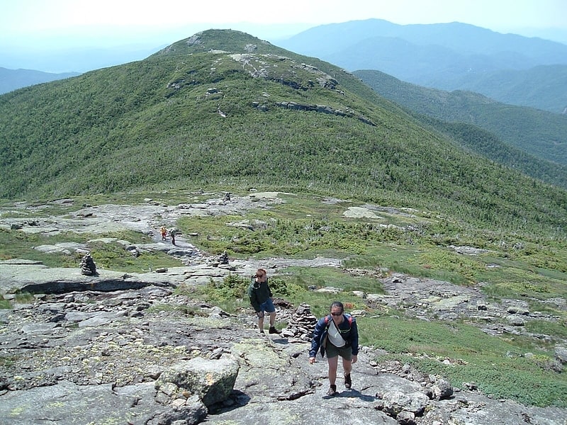
Algonquin Peak
Mountain in New York State. Algonquin Peak is in the MacIntyre Range in the town of North Elba, in Essex County, New York. It is the second highest mountain in New York, and one of the 46 Adirondack High Peaks in Adirondack Park. Its name comes from its reputedly being on the Algonquian side of a nearby informal boundary between the Algonquian and their Iroquois neighbors.
Algonquin is popular with hikers, accessible from the popular Adirondak Loj trailhead near Heart Lake outside Lake Placid for a day trip. While the climb is shorter than that of nearby Mount Marcy, it is steeper, requiring almost as much vertical ascent in a considerably shorter distance.
The usual route is via the blue-blazed Van Hoevenberg Trail 1.0 mile (1.6 km) to its junction with the yellow-blazed MacIntyre Range Trail and following that the remaining 3.3 miles (5 km) to the summit, during which the route gets progressively steeper and rockier, going over many steep rock chutes called "slides".
The mountain's summit is an alpine zone above tree line, and views of the surrounding high peaks are available in all directions. However, the large numbers of hikers on the summit have in the past caused damage to the fragile plant life, and strict regulations have been put in place both at the trailhead and on the summit (all hikers must sign in; no dogs are allowed without a leash) to protect it. On busy days a Summit Steward both reminds hikers of these rules and educates them about the ecosystem.
Less frequently, the mountain is approached from the southeast via the steep, narrow, 2.1-mile (3.4 km) Boundary Trail from Lake Colden. This trail is also dangerous because of the poor markings and steep, slippery slides that streams have formed on.[6]
Ampersand Mountain
Mountain in New York State. Ampersand Mountain is a 3,352 ft mountain in Franklin County in the High Peaks Wilderness Area of the northeastern Adirondacks, west of the High Peaks proper in New York State. The trail up the mountain begins on New York State Route 3 8.1 miles southwest of the village of Saranac Lake, near Middle Saranac Lake; it is a popular day hike. The mountain takes its name from nearby Ampersand Creek, so named because it twists and turns like the ampersand symbol. The summit is bare rock, with extensive views of the High Peaks to the east and the Saranac Lakes to the west. Stony Creek Mountain is located west-southwest of Ampersand Mountain. The mountain is notable as the land surrounding its hiking trail's initial ascent is generally acknowledged as unlogged old growth forest.[7]
Mount Colden
Peak in New York State. Mount Colden is the eleventh-highest peak in the High Peaks of the Adirondack Mountains, New York, United States. The peak was named after David S. Colden, an investor in the McIntyre Iron Works, in 1836. The peak was briefly renamed "Mount McMartin" the next year, but the older name persisted. The mountain is known for its distinctive Trap Dike, a large crevice running up the center of the mountain, which can clearly be seen from Avalanche Lake.
There are two maintained trails up Mount Colden. The first, which approaches from the northeast, passes by Lake Arnold before ascending the summit after crossing over several false summits. This trail was laid out in 1966 to replace a steeper trail which ascended the southeast face of the mountain and which was abandoned by 1975. The second trail, which is steeper, approaches from the southwest, starting from Lake Colden. Both approaches can be reached from the popular Adirondak Loj trailhead. After hiking from the Loj to the Avalanche Lean-Tos, climbers can head southwest through Avalanche Pass and past Avalanche Lake to reach Lake Colden and the trail to Colden from the southwest. Alternatively, they can head southeast to reach Lake Arnold and the northeast approach. Lake Colden and the southwest approach can also be reached from the Upper Works trailhead. Finally, the summit of Mount Colden can be reached by climbing the Trap Dike from Avalanche Lake. This approach leads to a long slide and a short bushwhack to the summit. This last approach does not follow a maintained trail, is extremely steep in places, and should be used with caution.[8]
Wright Peak
Peak in New York State. Wright Peak is the 16th highest peak in the High Peaks of the Adirondack Park, and is located in the MacIntyre Range in the town of North Elba, New York, in Essex County, New York. Named for N.Y. Governor Silas Wright, Wright is the northernmost peak in the MacIntyre Range, and is one of the windiest peaks in the park, as well as one of the best for back-country skiing. There are long slides from the summit that lead to Marcy Dam which are often skied in the winter.
The usual approach to Wright Peak is from the Adirondak Loj, heading 1.3 miles (2.1 km) up the Van Hovenberg trail, then ascending the steep MacIntyre Range Trail to the junction for Algonquin Peak; a left turn takes the climber.4 miles and up the last few hundred feet of elevation through the alpine zone. Wright is often hiked in conjunction with Algonquin and sometimes Iroquois Peak by peakbaggers, making for one of the toughest hikes in the region.[9]
Lake Tear of the Clouds
Tarn in New York State. Lake Tear of the Clouds is a small tarn located in the town of Keene, in Essex County, New York, United States, on the southwest slope of Mount Marcy, the state's highest point, in the Adirondack Mountains. It is the highest pond in the state at 4,293 feet. It is often cited as the highest source of the Hudson River, via Feldspar Brook, the Opalescent River and Calamity Brook.
The Hudson River as named actually begins several miles southwest at the outlet of Henderson Lake in Newcomb, New York.
In 1872 Verplanck Colvin described the lake as part of a survey of the Adirondack Mountains. He wrote:
Far above the chilly waters of Lake Avalanche at an elevation of 4,293 feet lies summit water, a minute, unpretending, tear of the clouds — as it were — a lovely pool shivering in the breezes of the mountains and sending its limpid surplus through Feldspar Brook to the Opalescent River, the well-spring of the Hudson.
On September 14, 1901, then-US Vice President Theodore Roosevelt was at Lake Tear of the Clouds after returning from a hike to the Mount Marcy summit when he received a message informing him that President William McKinley, who had been shot two weeks earlier but was expected to survive, had taken a turn for the worse. Roosevelt hiked down the mountain back to the Upper Tahawus Club, Tahawus, New York, where he had been staying. He then took a 40-mile (64 km) midnight stage coach ride through the Adirondacks to the Adirondack Railway station at North Creek, New York, where he discovered that McKinley had died. Roosevelt took the train to Buffalo, New York, where he was officially sworn in as President. The route is now designated the Roosevelt-Marcy Trail.
In August 2016, scientists from Riverkeeper, CUNY Queens College, and Columbia University's Lamont–Doherty Earth Observatory gathered water samples at the lake to complete a first-of-its kind water quality test along the entire span of the 315-mile-long (507 km) Hudson River.[10]
Mount Haystack
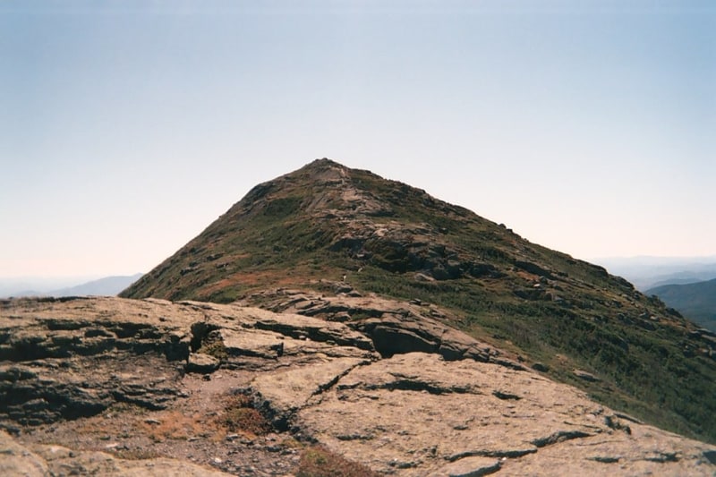
Mountain in New York State. Mount Haystack is a mountain in the Great Range of the Adirondack High Peaks in the Adirondack Mountains of New York. It is the third highest peak in the state, after Algonquin Peak and Mount Marcy. It gets its name from the resemblance of its rounded, conical peak to a haystack.
Despite this and the views offered from its bare, alpine summit, it is not visited by as many hikers outside aspiring members of the Adirondack Forty-Sixers; it is rather remote from the nearest trailhead and the approach from either direction is steep and challenging.
The most frequent approach of Haystack as the main goal is to follow the Johns Brook Trail from the popular Garden parking area in Keene Valley to the Phelps Trail and then use Shorey's Short Cut to get over to the Range Trail. It is possible to combine this with an attempt on Marcy itself, but that makes for a long day and the approach from Panther Gorge is even steeper than that from the north.
Some hikers come along the Great Range itself, making the peak their last stop before Marcy itself, or combine it with neighboring Basin and Saddleback. It can also be approached from privately owned Upper Ausable Lake.
One of the most famous elements of Haystack is the infamous "Devil's Half Mile". This stretch, which is technically three-quarters mile (1.2 km), is the extremely steep last stretch of the trail.[11]
Iroquois Peak
Peak in New York State. Iroquois Peak is the eighth-highest peak in the Adirondack Mountains in New York State, U.S., and is part of the MacIntyre Range, which also includes Wright Peak, Mount Marshall, and Algonquin Peak. Although the mountain does not have an officially maintained trail, a well-maintained "herd path" leads to the summit from the northeast.[12]
Santanoni Peak
Mountain in New York State. Santanoni Peak is a mountain located in Essex County, New York. The mountain is part of the Santanoni Mountains of the Adirondacks. The mountain's name is believed to be an Abenaki derivative of "Saint Anthony"; the first French fur traders and missionaries having named the area for Saint Anthony of Padua. Santanoni Peak is flanked to the north by Panther Peak, and to the southwest by Little Santanoni Mountain.
The east slopes of Santanoni Peak drain into the eastern Santanoni Brook, thence into Henderson Lake, the source of the Hudson River, and into New York Bay. The south end of Santanoni Peak drains into the southern Santanoni Brook, thence into Newcomb Lake, the Newcomb River, and the Hudson River. The southwest side of Santanoni drains into Ermine Brook, thence into Moose Creek, the Cold River, the Raquette River, the Saint Lawrence River in Canada, and into the Gulf of Saint Lawrence. The west slopes of Santanoni drain into Calahan Brook, thence into Moose Creek.
Santanoni Peak is within the High Peaks Wilderness Area of New York's Adirondack Park.[13]
Wallface Mountain
Mountain in New York State. Wallface Mountain is a mountain located in Essex County, New York. The mountain is named after the cliff on its southeastern side. Wallface is flanked to the west by MacNaughton Mountain, and faces Mount Marshall to the southeast across Indian Pass.
The southeast and west sides of Wallface Mountain drain into the southern Indian Pass Brook, thence into Henderson Lake, the source of the Hudson River, which drains into New York Bay. The northern slopes of Wallface Mountain drain into the northern Indian Pass Brook, thence into the West Branch of the Ausable River, into Lake Champlain, thence into Canada's Richelieu River, the Saint Lawrence River, and into the Gulf of Saint Lawrence.
Wallface Mountain is within the High Peaks Wilderness Area of New York's Adirondack Park.[14]
Mount Skylight
Mountain in New York State. Mount Skylight is a mountain in the Adirondack High Peaks in the Adirondack Mountains of New York. It gets its name from its open, bare and relatively flat summit, unusual in the Adirondack High Peaks. Skylight is the fourth highest peak in New York.
A remote summit by any approach, it is nonetheless a favorite of hikers. It is famously distinguished by two large cairns that have grown on either end of the summit over the years, as 46er lore has it that carrying a rock up and placing it on them will ensure good weather.
A single trail goes up to the mountain's summit from the Four Corners junction between Skylight and Mount Marcy, its northern neighbor. As the name suggests, there are three ways to get there. Most commonly, hikers come from the west, via the Feldspar Brook Trail from the campsites at the Flowed Lands and climb the peak in conjunction with a visit to Lake Tear of the Clouds (often considered the source of the Hudson River), and a climb up neighboring, trail-less Gray Peak. The trailhead can also be reached by descending from Marcy to the north, or via Panther Gorge and Elk Lake to the southeast, all very lengthy trips that are usually done via an overnight backpack.[15]