Discover 11 hidden attractions, cool sights, and unusual things to do in Hawaii Volcanoes National Park (United States). Don't miss out on these must-see attractions: Puʻu ʻŌʻō, Kīlauea, and Mauna Loa. Also, be sure to include Kīlauea Iki in your itinerary.
Below, you can find the list of the most amazing places you should visit in Hawaii Volcanoes National Park (Hawaii).
Table of Contents
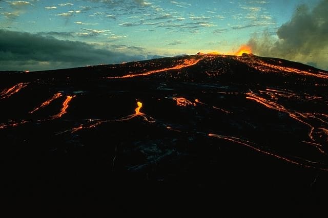
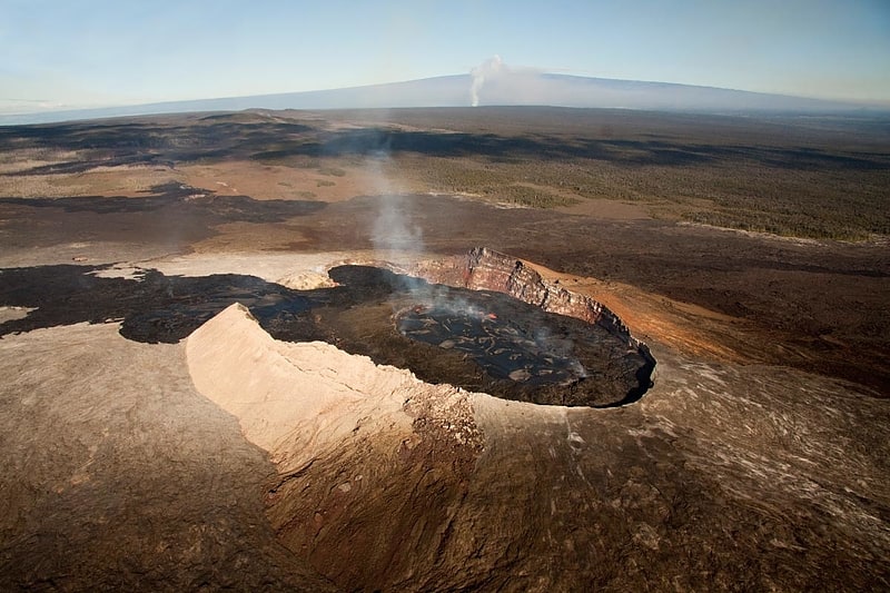
Puʻu ʻŌʻō
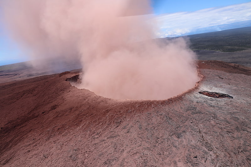
Prominent volcano known for lava outpour. Puʻu ʻŌʻō is a volcanic cone on the eastern rift zone of Kīlauea volcano in the Hawaiian Islands. The eruption that created Puʻu ʻŌʻō began on January 3, 1983, and continued nearly continuously until April 30, 2018, making it the longest-lived rift-zone eruption of the last two centuries.
By January 2005, 2.7 cubic kilometers (0.65 cu mi) of magma covered an area of more than 117 square kilometers (45 sq mi) and added 230 acres (0.93 km2) of land to the southeast coast of Hawaiʻi. The eruption claimed at least 189 buildings and 14 kilometers (8.7 mi) of highways, as well as a church, a store, the Wahaʻula Visitor Center, and many ancient Hawaiian sites, including the Wahaʻula heiau. The coastal highway has been closed since 1987, as parts of the road have been buried under lava up to 35 meters (115 ft) thick.[1]
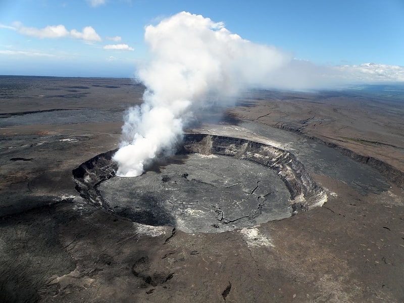
Kīlauea
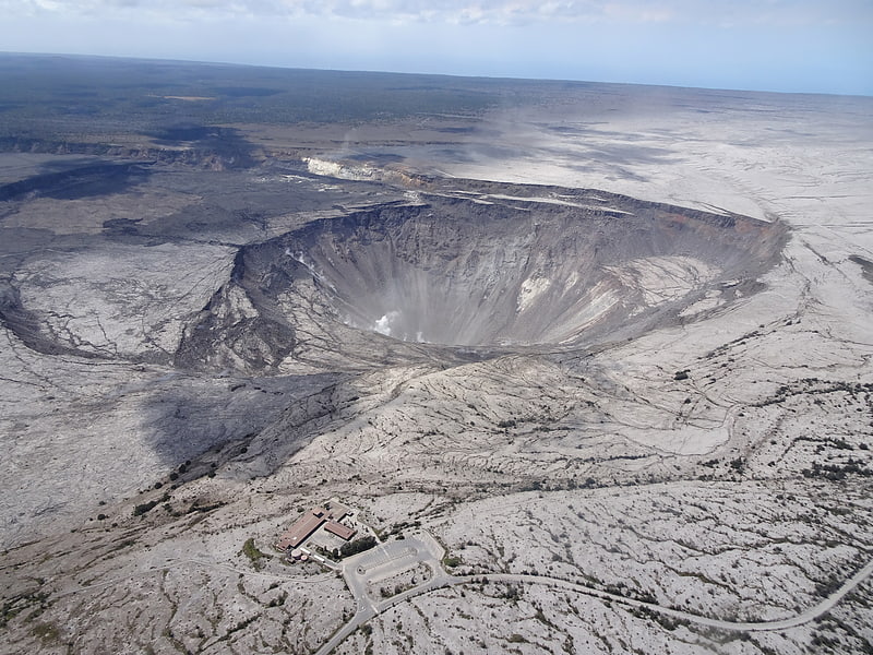
Shield volcano in Hawaii. Kīlauea is an active shield volcano in the Hawaiian Islands. Historically, it is the most active of the five volcanoes that together form the Big Island of Hawaiʻi. Located along the southeastern shore of the island, the volcano is between 210,000 and 280,000 years old and emerged above sea level about 100,000 years ago. Its most recent eruption began on September 29, 2021.
It is the second-youngest product of the Hawaiian hotspot and the current eruptive center of the Hawaiian–Emperor seamount chain. Because it lacks topographic prominence and its activities historically coincided with those of Mauna Loa, Kīlauea was once thought to be a satellite of its much larger neighbor. Structurally, Kīlauea has a large, fairly recently formed caldera at its summit and two active rift zones, one extending 125 km (78 mi) east and the other 35 km (22 mi) west, as an active fault of unknown depth moving vertically an average of 2 to 20 mm (0.1 to 0.8 in) per year.
Between 2008 and 2018, Halemaʻumaʻu, a pit crater in the volcano's summit caldera, hosted an active lava lake. Kīlauea also erupted nearly continuously from vents on its eastern rift zone between January 1983 and April 2018, causing considerable property damage, including the destruction of the towns of Kalapana and Kaimū along with the community's renowned black sand beach, in 1990. Beginning in May 2018, activity shifted further downrift from the summit to the Puna district, during which lava erupted from two dozen vents. The eruption saw vigorous eruptive lava fountains that sent destructive rivers of molten rock into the ocean in three places. The eruption destroyed Hawaii's largest natural freshwater lake, covered substantial portions of Leilani Estates and Lanipuna Gardens, and completely inundated the communities of Kapoho, Vacationland Hawaii, and most of the Kapoho Beach Lots. Lava also filled Kapoho Bay and extended new land nearly a mile into the sea. The County of Hawaii reported that 716 dwellings were destroyed by lava. Concurrent with the activity in Puna, the lava lake within Halemaʻumaʻu drained and a series of explosive collapse events occurred at the volcano's summit, with at least one explosion emitting ash 30,000 feet (9,100 m) into the air. This activity prompted a months-long closure of the Kīlauea section of Hawaii Volcanoes National Park. The eruption ended in September 2018. After more than two years of quiescence, Kīlauea erupted again between December 2020 and May 2021 within Halemaʻumaʻu crater, where lava erupted from several vents boiled off a water lake that had been growing within the crater for more than a year, replacing it with a lava lake 229 metres (751 ft) deep.
A new eruption began on September 29, 2021, when several vents began to erupt lava within Halemaʻumaʻu.[2]
Mauna Loa
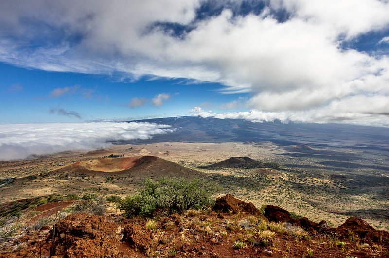
Largest active volcano on the planet. Mauna Loa is one of five volcanoes that form the Island of Hawaii in the U.S. state of Hawaiʻi in the Pacific Ocean. The largest subaerial volcano in both mass and volume, Mauna Loa has historically been considered the largest volcano on Earth, dwarfed only by Tamu Massif. It is an active shield volcano with relatively gentle slopes, with a volume estimated at 18,000 cubic miles, although its peak is about 125 feet lower than that of its neighbor, Mauna Kea. Lava eruptions from Mauna Loa are silica-poor and very fluid, and they tend to be non-explosive.
Mauna Loa has probably been erupting for at least 700,000 years, and may have emerged above sea level about 400,000 years ago. The oldest-known dated rocks are not older than 200,000 years. The volcano's magma comes from the Hawaii hotspot, which has been responsible for the creation of the Hawaiian island chain over tens of millions of years. The slow drift of the Pacific Plate will eventually carry Mauna Loa away from the hotspot within 500,000 to one million years from now, at which point it will become extinct.
Mauna Loa's most recent eruption occurred from March 24 to April 15, 1984. No recent eruptions of the volcano have caused fatalities, but eruptions in 1926 and 1950 destroyed villages, and the city of Hilo is partly built on lava flows from the late 19th century. Because of the potential hazards it poses to population centers, Mauna Loa is part of the Decade Volcanoes program, which encourages studies of the world's most dangerous volcanoes. Mauna Loa has been monitored intensively by the Hawaiian Volcano Observatory since 1912. Observations of the atmosphere are undertaken at the Mauna Loa Observatory, and of the Sun at the Mauna Loa Solar Observatory, both located near the mountain's summit. Hawaii Volcanoes National Park covers the summit and portions of the southeastern and southwestern flanks of the volcano, and also incorporates Kīlauea, a separate volcano.[3]
Kīlauea Iki
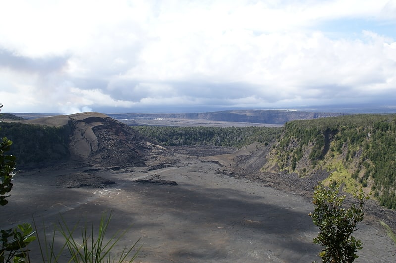
Kīlauea Iki is a pit crater that is next to the main summit caldera of Kīlauea on the island of Hawaiʻi in the Hawaiian Islands. It is known for its eruption in 1959 that started on November 14th and ended on December 20th, producing lava fountaining up to 1900 feet and a lava lake in the crater. Today, the surface of the lava lake has cooled and it is now a popular hiking destination to view the aftermath of an eruption.[4]
Hōlei Sea Arch
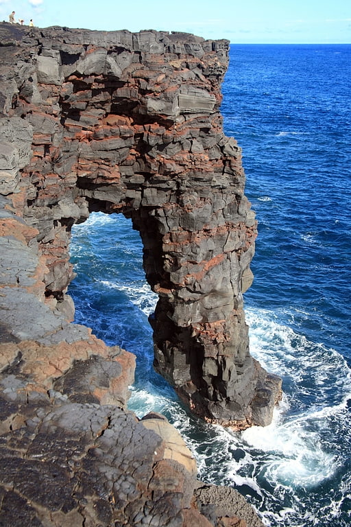
Hōlei Sea Arch is a 90-foot -high natural arch located in Hawaii, on the southern coast of the Big Island, south of Kīlauea. This rock formation was born from marine erosion, in which the waves of the Pacific Ocean create this natural bridge of lava cliffs. The arch is made of basalt. It takes its name from the Hōlei Pali, the escarpment located up on the slopes of the volcano.
Located in the Ka'ū District of Hawaii County and in the Hawaii Volcanoes National Park, it is at the end of the Chain of Craters Road, cut short by the lava flows emitted by Puu Oo Crater since 1990. It thus constitutes a tourist attraction of the national park.[5]
Address: Chain of Craters Road, Hawaii Volcanoes National Park (Puna)
Chain of Craters Road
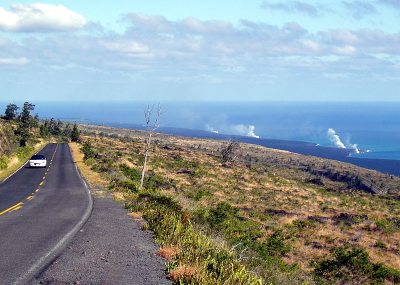
Road in Hawaii County, Hawaii. Chain of Craters Road is a 19-mile long winding paved road through the East Rift and coastal area of the Hawaii Volcanoes National Park on the island of Hawaii, in the state of Hawaii, United States. The original road, built in 1928, connected Crater Rim Drive to Makaopuhi Crater. The road was lengthened to reach the tiny town of Kalapana in 1959. As of 2018, the road has had parts covered by lava in 41 of the past 53 years, due to eruptions of Kīlauea volcano.[6]
Pauahi Crater
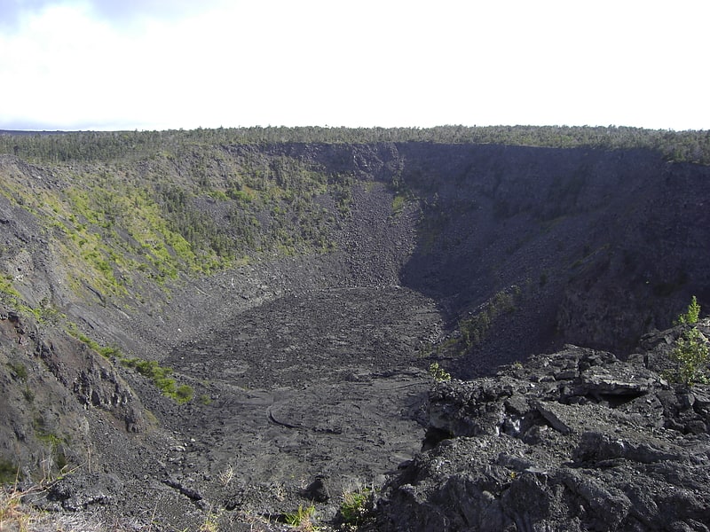
Pauahi Crater is a volcanic crater measuring 2,000 ft long, up to some 1,300 ft across, and 300 ft deep in Hawaii Volcanoes National Park at 19°22′6″N 155°13′21″W. It is about 3 mi from the top of the Big Island of Hawaii's Chain of Craters Road, which follows a "chain" that also includes the Hiʻiaka, Puʻu Huluhulu, Kānenuiohamo, Makaopuhi and Nāpau craters.[7]
Mauna Ulu
Mauna Ulu is a volcanic cone in the eastern rift zone of the Kīlauea volcano on the island of Hawaii. It falls within the bounds of Hawaiʻi Volcanoes National Park. Mauna Ulu was in a state of eruption from May 1969 to July 1974.[8]
Hawaiian Volcano Observatory
Museum. The Hawaiian Volcano Observatory is an agency of the U.S. Geological Survey and one of five volcano observatories operating under the USGS Volcano Hazards Program. Based in Hilo, Hawaii, the observatory monitors six Hawaiian volcanoes: Kīlauea, Mauna Loa, Lōʻihi, Hualālai, Mauna Kea, and Haleakalā, of which, Kīlauea and Mauna Loa are the most active. The observatory has a worldwide reputation as a leader in the study of active volcanism. Due to the relatively non-explosive nature of Kīlauea's volcanic eruptions for many years, scientists have generally been able to study ongoing eruptions in proximity without being in extreme danger.
Prior to May 2018, the observatory's offices were located at Uwekahuna Bluff, the highest point on the rim of Kīlauea Caldera. The summit collapse events during the 2018 eruption of Kīlauea damaged those facilities, so the observatory has since been operating from various temporary offices located in Hilo on the Island of Hawaiʻi.[9]
Kaʻū Desert
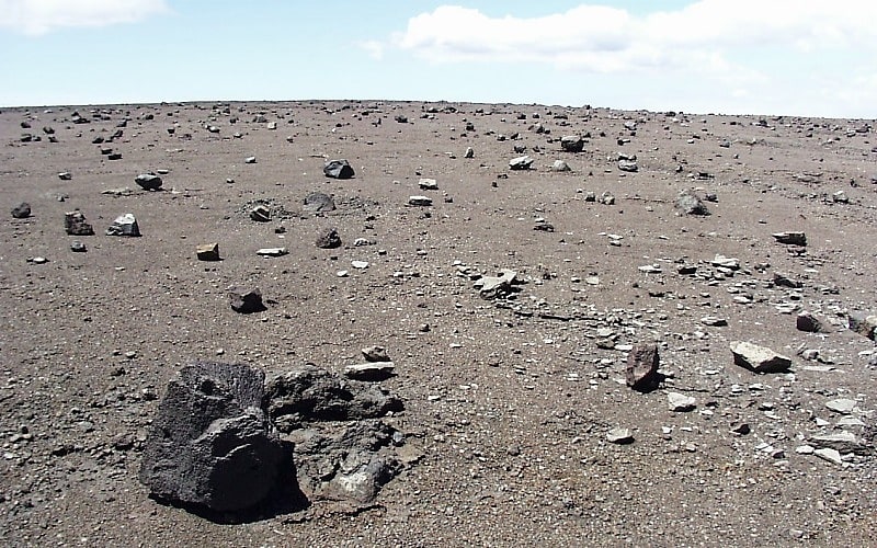
The Kaʻū Desert is a leeward desert in the district of Kaʻū, the southernmost district on the Big Island of Hawaii, and is made up mostly of dried lava remnants, volcanic ash, sand and gravel. The desert covers an area of the Kīlauea Volcano along the Southwest rift zone. The area lacks any vegetation, mainly due to acid rainfall.[10]
Kilauea
Active volcano popular among tourists. Kīlauea is an active shield volcano in the Hawaiian Islands. Historically, it is the most active of the five volcanoes that together form the Big Island of Hawaiʻi. Located along the southeastern shore of the island, the volcano is between 210,000 and 280,000 years old and emerged above sea level about 100,000 years ago. Its most recent eruption began on September 29, 2021.
It is the second-youngest product of the Hawaiian hotspot and the current eruptive center of the Hawaiian–Emperor seamount chain. Because it lacks topographic prominence and its activities historically coincided with those of Mauna Loa, Kīlauea was once thought to be a satellite of its much larger neighbor. Structurally, Kīlauea has a large, fairly recently formed caldera at its summit and two active rift zones, one extending 125 km (78 mi) east and the other 35 km (22 mi) west, as an active fault of unknown depth moving vertically an average of 2 to 20 mm (0.1 to 0.8 in) per year.
Between 2008 and 2018, Halemaʻumaʻu, a pit crater in the volcano's summit caldera, hosted an active lava lake. Kīlauea also erupted nearly continuously from vents on its eastern rift zone between January 1983 and April 2018, causing considerable property damage, including the destruction of the towns of Kalapana and Kaimū along with the community's renowned black sand beach, in 1990. Beginning in May 2018, activity shifted further downrift from the summit to the Puna district, during which lava erupted from two dozen vents. The eruption saw vigorous eruptive lava fountains that sent destructive rivers of molten rock into the ocean in three places. The eruption destroyed Hawaii's largest natural freshwater lake, covered substantial portions of Leilani Estates and Lanipuna Gardens, and completely inundated the communities of Kapoho, Vacationland Hawaii, and most of the Kapoho Beach Lots. Lava also filled Kapoho Bay and extended new land nearly a mile into the sea. The County of Hawaii reported that 716 dwellings were destroyed by lava. Concurrent with the activity in Puna, the lava lake within Halemaʻumaʻu drained and a series of explosive collapse events occurred at the volcano's summit, with at least one explosion emitting ash 30,000 feet (9,100 m) into the air. This activity prompted a months-long closure of the Kīlauea section of Hawaii Volcanoes National Park. The eruption ended in September 2018. After more than two years of quiescence, Kīlauea erupted again between December 2020 and May 2021 within Halemaʻumaʻu crater, where lava erupted from several vents boiled off a water lake that had been growing within the crater for more than a year, replacing it with a lava lake 229 metres (751 ft) deep.
A new eruption began on September 29, 2021, when several vents began to erupt lava within Halemaʻumaʻu.[11]