Discover 15 hidden attractions, cool sights, and unusual things to do in Guatemala. Don't miss out on these must-see attractions: Volcán de Agua (Antigua Guatemala), Antigua Guatemala Cathedral (Antigua Guatemala) or Acatenango (Antigua Guatemala).
Below, you can find the list of the most amazing places you should visit in Guatemala.
Table of Contents
Volcán de Agua, Antigua Guatemala
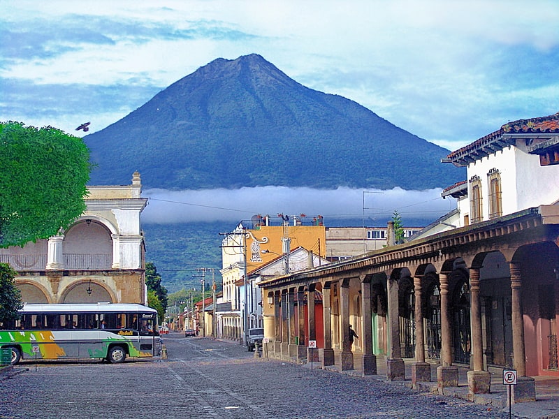
Stratovolcano in Guatemala. Volcán de Agua is a stratovolcano located in the departments of Sacatepéquez and Escuintla in Guatemala. At 3,760 m, Agua Volcano towers more than 3,500 m above the Pacific coastal plain to the south and 2,000 m above the Guatemalan Highlands to the north. It dominates the local landscape except when hidden by cloud cover. The volcano is within 5 to 10 km of the city of Antigua Guatemala and several other large towns situated on its northern apron. These towns have a combined population of nearly 100,000. It is within about 20 km of Escuintla to the south. Coffee is grown on the volcano's lower slopes.[1]
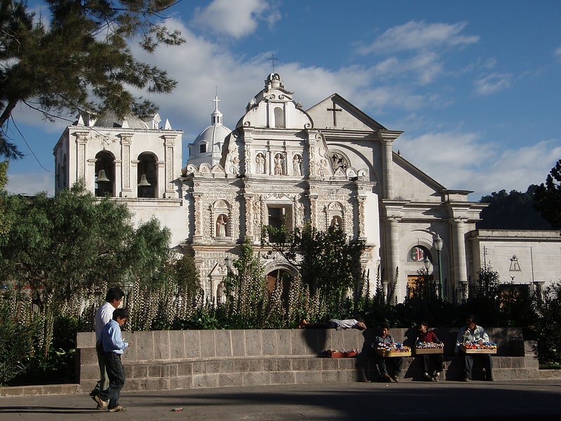
Antigua Guatemala Cathedral, Antigua Guatemala
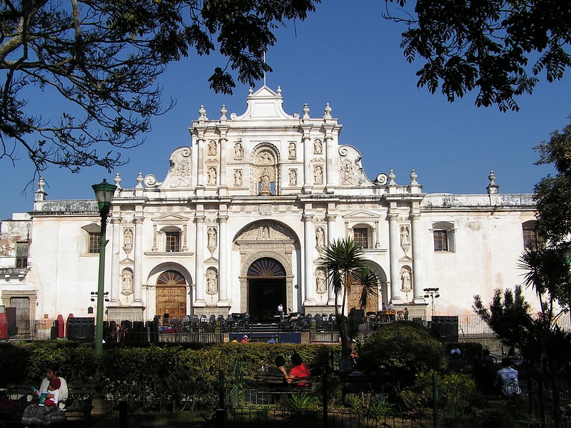
Also known as: Catedral de San José
Remains of an imposing 1540s cathedral. Antigua Guatemala Cathedral is a Latin Catholic church in Antigua Guatemala, Guatemala. The original church was built around 1541, but suffered several earthquakes throughout its history, and the first church building was demolished in 1669. The cathedral was rebuilt and consecrated in 1680. By 1743 the cathedral was one of the largest in Central America. However, the devastating 1773 Guatemala earthquake seriously damaged much of the building, though the two towers at the front remained largely intact. These have undergone restoration work, and the cathedral has been partly rebuilt[2]
Address: 4a. Avenida, Antigua Guatemala
Acatenango, Antigua Guatemala
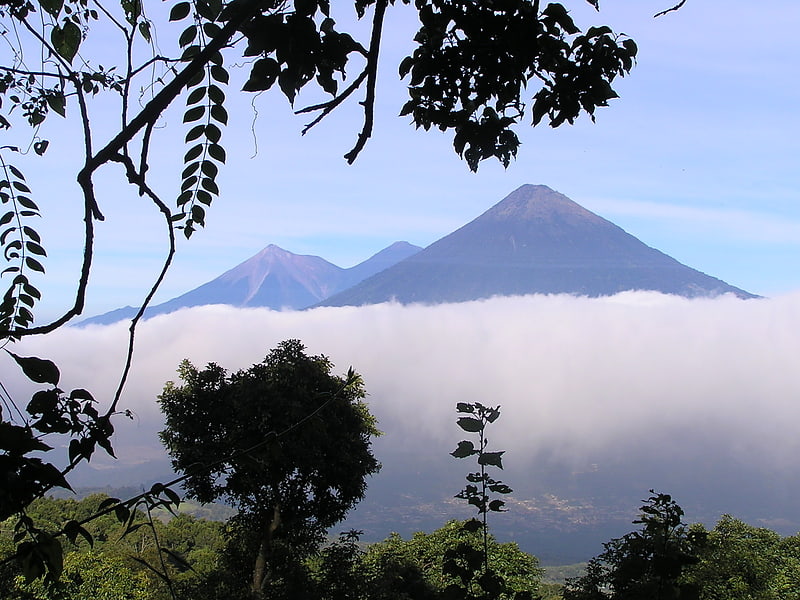
Stratovolcano in Guatemala. Acatenango is a stratovolcano in Guatemala, close to the city of Antigua. The volcano has two peaks, Pico Mayor and Yepocapa which is also known as Tres Hermanas. Acatenango is joined with Volcán de Fuego and collectively the volcano complex is known as La Horqueta.[3]
Address: Volcan Acatenango, 03001 Antigua Guatemala
Zona Viva, Guatemala City
Shopping, Shopping district, Neighbourhood, Sushi
Address: Zona 10, Guatemala City
Palacio Nacional, Guatemala City
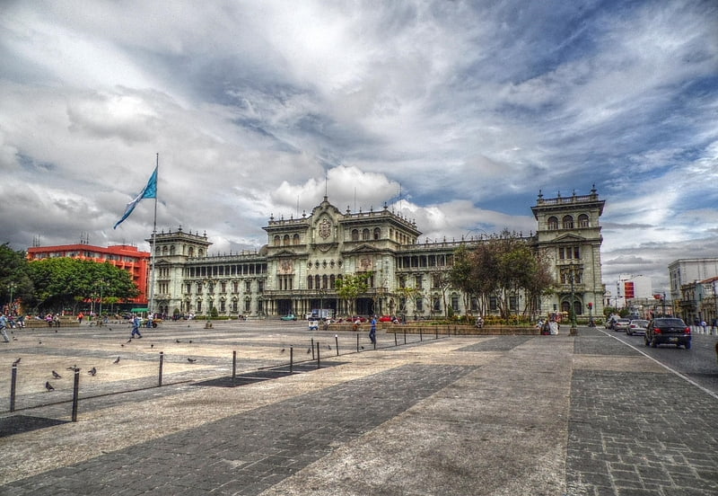
Building in Guatemala City, Guatemala. Known as Palacio Nacional de la Cultura also known colloquially as "Palacio Verde", it is identified as Guatemala City's symbol in its architectural context. It was the most important building in Guatemala and was the headquarters of the President of Guatemala. The building is the origin of all the roads in the Republic and has a spot known as Kilometro Cero. It is presently a museum and is also used for important acts of the government.[4]
Address: 6 Avenida, 01001 Ciudad de Guatemala
Relief map of Guatemala, Guatemala City
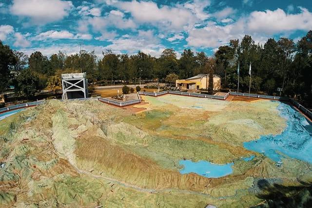
Open air museum in Guatemala City, Guatemala. The Relief Map of Guatemala is a huge relief map of Guatemala erected at ground level on two scales: 1: 10,000 for the horizontal extension and 1: 2,000 for the vertical, on an approximate surface of 1,800 square meters.[5]
Address: Final Avenida Simeón Cañas, zona 2, Guatemala City
Tayasal Archaeological Site, Flores, Petén
Tayasal is a Maya archaeological site located in present-day Guatemala. It was a large Maya city with a long history of occupation. Tayasal is a corruption of Tah Itza, a term originally used to refer to the core of the Itza territory in Petén. The name Tayasal was applied in error to the archaeological site, and originally applied to the Itza capital. However, the name now refers to the peninsula supporting both the archaeological site and the village of San Miguel. The site was occupied from the Middle Preclassic period through to the Late Postclassic.
The site is a protected national monument.[6]
Motul de San José, Flores, Petén
Village in Guatemala. Motul de San José is an ancient Maya site located just north of Lake Petén Itzá in the Petén Basin region of the southern Maya lowlands. It is a few kilometres from the modern village of San José, in Guatemala's northern department of Petén. A medium-sized civic-ceremonial centre, it was an important political and economic centre during the Late Classic period.
The site was first settled between 600 and 300 BC, in the latter portion of the Middle Preclassic period, when it most likely was a fairly small site. This Maya city then had a long and continuous occupational history until the Early Postclassic, up to around AD 1250, with peaks in the Late Preclassic and Late Classic periods. Motul de San José had begun to refer to Tikal as its overlord in the late 4th century AD; by the 7th century it had switched its allegiance to Calakmul, Tikal's great rival, before returning its allegiance to Tikal in the early 8th century. In the late 8th century Motul de San José appears to have been conquered by Dos Pilas, capital of the Petexbatún kingdom.
Most natural resources were easily available in the immediate vicinity of the city. The nearby port at La Trinidad de Nosotros was an important hub for the import of exotic goods and export of local products such as chert and ceramics. Other goods not immediately available were likely to have been provided by the city's satellite sites. The local area provided a number of different soils suitable for varied agricultural use, and the port at La Trinidad de Nosotros provided the city with freshwater products such as turtles, crocodiles and freshwater molluscs. Deer were hunted locally and provided an important source of protein for the upper class, while freshwater snails were the main source of protein for commoners.
Motul de San José has been identified as the source of Ik-style polychrome ceramics bearing painted scenes of the Late Classic Maya aristocracy involved in a variety of courtly activities. The Ik-style was characterised by hieroglyphs painted in a pink or pale red colour, scenes with dancers wearing masks, and the realistic representation of subjects as they appeared in life. The city was the capital of a polity that included various satellite sites of varying importance, including a port on the shore of Lake Petén Itzá.[7]
Tikal Temple V, Maya Biosphere Reserve
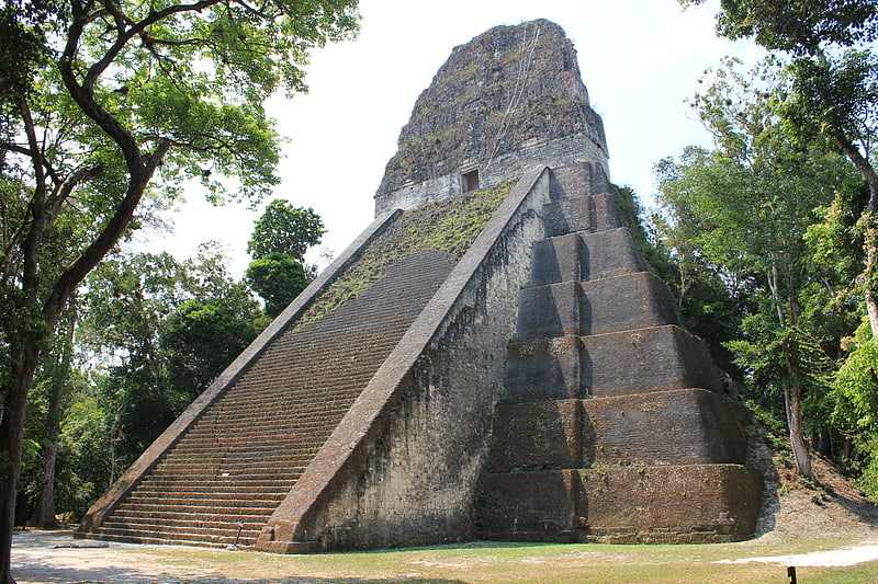
Ruin in Tikal, Guatemala. Tikal Temple V is the name given by archaeologists to one of the major pyramids at Tikal. Tikal is one of the most important archaeological sites of the pre-Columbian Maya civilization and is located in the Petén Department of northern Guatemala.
Temple V stands south of the Central Acropolis and is the mortuary pyramid of an as yet unidentified ruler of the once great city. The temple stands 57 metres (187 ft) high, making it the second tallest structure at Tikal—only Temple IV is taller. The temple has been dated to about AD 700, in the Late Classic period, via radiocarbon analysis and the dating of ceramics associated with the structure places its construction during the reign of Nun Bak Chak in the second half of the 7th century.
The architectural style of the pyramid includes features that were popular during the Early Classic period, such as wide balustrades flanking the main stairway and the rounded corners of the temple. These features indicate the continued influence of earlier traditions.[8]
San Andrés, Flores, Petén
San Andrés is a municipality in the department of El Petén in Guatemala. The municipality is formed by the town of San Andrés, located on the north-western shore of Lake Petén Itzá, and 55 rural communities, with a total population of 20,295 people.
The municipality was created in 1962 and has a territory 8,874 km², equivalent to 25% of the department of El Petén. In the 1990s, more than 93% (8,288 km²) of the municipality's territory was declared protected nature reserve by the central government.[9]
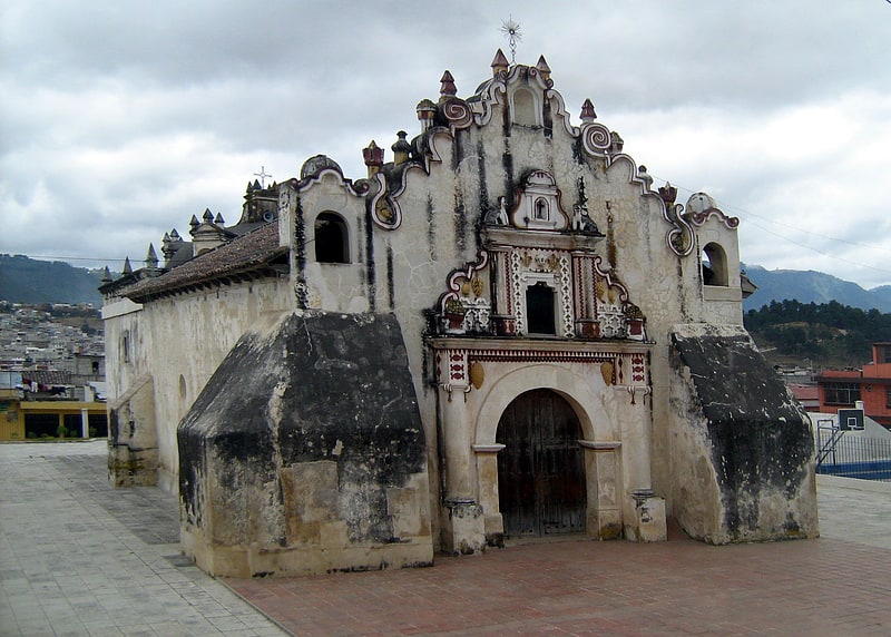
Holy Spirit Cathedral, Quetzaltenango
Also known as: Catedral del Espíritu Santo de Quetzaltenango
Cathedral in Quetzaltenango, Guatemala. The Holy Spirit Cathedral also called Quetzaltenango Cathedral, is a Catholic church in Quetzaltenango, Guatemala. It was founded by the conquistadors, shortly after having defeated the legendary local hero Tecun Uman. The city was dedicated by the Spanish to the Holy Spirit.
This church, one of the first to be founded in Quetzaltenango, contains two of the most revered images of the region: The Divine Just Judge and the Virgin of the Rosary. The two images come out in procession on Good Friday and during the holidays in October respectively.
The present Cathedral suffered at least 3 changes in the last modification remained the facade.[10]
Teatro Roma, Quetzaltenango
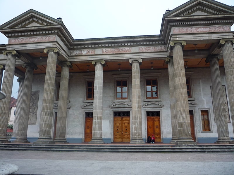
Also known as: Teatro Municipal de Quetzaltenango
Theatre in Quetzaltenango, Guatemala. The Quetzaltenango Municipal Theatre, known as the Teatro Municipal is a theatre in Quetzaltenango, Guatemala.
The historical building still hosts theatrical presentations and is also noted for its jazz performances which attract many visitors to the theatre.[11]
Temple I, Maya Biosphere Reserve
Also known as: Templo del Gran Jaguar
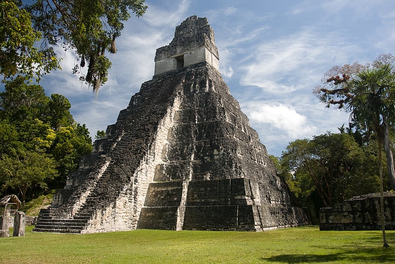
Legendary temple and historical site. Tikal Temple I is the designation given to one of the major structures at Tikal, one of the largest cities and archaeological sites of the pre-Columbian Maya civilization in Mesoamerica. It is located in the Petén Basin region of northern Guatemala. It also is known as the Temple of the Great Jaguar because of a lintel that represents a king sitting upon a jaguar throne. An alternative name is the Temple of Ah Cacao, after the ruler buried in the temple. Temple I is a typically Petén-styled limestone stepped pyramid structure that is dated to approximately 732 AD.
Situated at the heart of a World Heritage Site, the temple is surmounted by a characteristic roof comb, a distinctive Maya architectural feature. Building Temple I on the eastern side of the Great Plaza was a significant deviation from the established tradition of building funerary temples just north of the plaza in Tikal's North Acropolis.[12]
Chapel of San Jacinto, Quetzaltenango
Chapel in Guatemala. The Chapel of San Jacinto is a Roman Catholic chapel located in the town of Salcajá, Guatemala. It is said to have been founded by the Franciscans in 1524, the same year the Maya K'iche' kingdom was conquered by the Spanish conquistadores, and is claimed to be the first church built in Central America. Although there is no historical evidence to support that claim, the chapel can be considered a fine example of early Spanish colonial architecture.[13]
Temple IV, Maya Biosphere Reserve
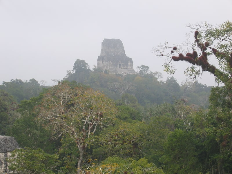
Also known as: Templo de la Serpiente Bicéfala
Historical landmark in Tikal, Guatemala. Tikal Temple IV is a Mesoamerican pyramid in the ruins of the ancient Maya city of Tikal in modern Guatemala. It was one of the tallest and most voluminous buildings in the Maya world. The pyramid was built around 741 AD. Temple IV is located at the western edge of the site core. Two causeways meet at the temple; the Tozzer Causeway runs east to the Great Plaza, while the Maudslay Causeway runs northeast to the Northern Zone. Temple IV is the second tallest pre-Columbian structure still standing in the New World, just after the Great Pyramid of Toniná in Chiapas, Mexico, although Teotihuacan's Pyramid of the Sun may once have been taller.
The pyramid was built to mark the reign of the 27th king of the Tikal dynasty, Yik'in Chan K'awiil, although it may have been built after his death as his funerary temple. Archaeologists believe that Yik'in Chan K'awiil's tomb lies undiscovered somewhere underneath the temple. The summit shrine faces eastward to the site core, with Temple III visible directly in front and Temple I and Temple II beyond it.[14]
Address: Parque Arqueologico Tikal, Maya Biosphere Reserve