Discover 25 hidden attractions, cool sights, and unusual things to do in Bolivia. Don't miss out on these must-see attractions: Valle de la Luna (La Paz), Plaza Murillo (La Paz) or National Mint of Bolivia (Potosí).
Below, you can find the list of the most amazing places you should visit in Bolivia.
Table of Contents
Valle de la Luna, La Paz
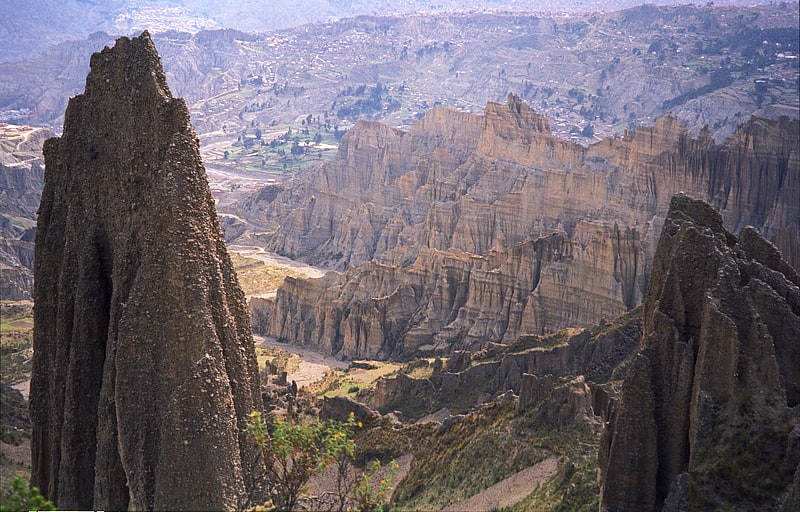
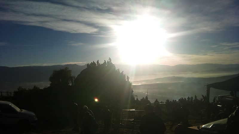
Large rock formations created by erosion. Valle de la Luna, also calling Killa Qhichwa is situated about 10 kilometers from downtown La Paz, in the Pedro Domingo Murillo Province, La Paz Department, Bolivia. It consists of an area where erosion has worn away the majority of a mountain, composed primarily of clay rather than rock, leaving tall spires. It is similar to another zone of La Paz that is known as El Valle de las Animas. It is an important site of the famous holiday, Dias de los Muertos.
Because the mineral content of the mountains varies greatly between individual mountains, the sides of the mountains are different colors, creating striking optical illusions. A majority of them are a clear beige or light brown color, but some are almost red, with sections of dark violet.[1]
Plaza Murillo, La Paz
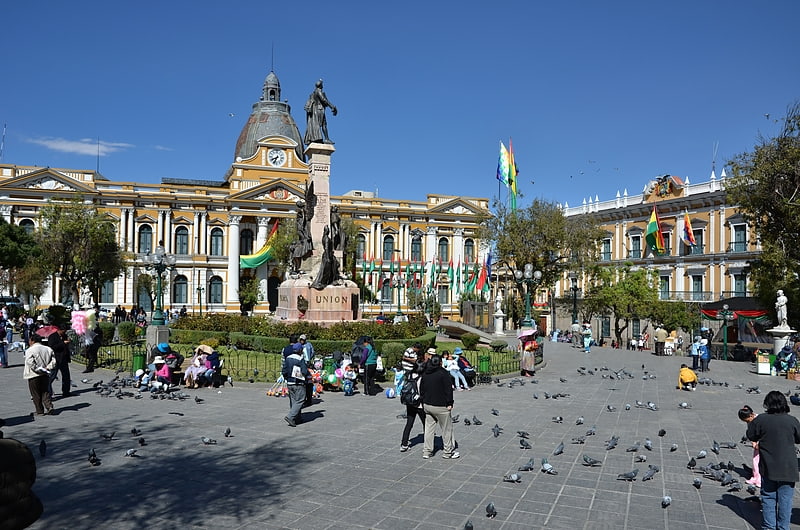
Major square with landmark buildings. The Plaza Murillo is the central plaza of the city of La Paz and the open space most connected to the political life of Bolivia. Prominent buildings on the plaza include the Presidential Palace, National Congress of Bolivia, and the Cathedral of La Paz. It is located in the old town, or Casco Viejo, of the city and is surrounded by Socabaya Street to the west, Ayacucho Street to the east, Comercio Street to the south, and a continuation of Ingavi and Ballivan Streets to the north.[2]
National Mint of Bolivia, Potosí
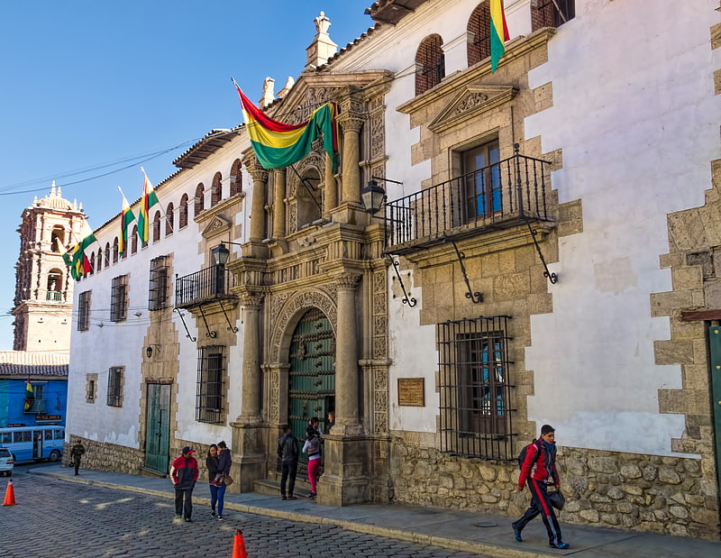
Also known as: Casa de la Moneda de Bolivia
National museum in Potosí, Bolivia. The National Mint of Bolivia or the Mint of Potosí is a mint located in the city of Potosí in Bolivia. It is from this mint that most of the silver shipped through the Spanish Main came.
The coinage minted during its period became so well known in the world that a saying, memorialized by Miguel de Cervantes, came into use: valer un potosí, "to be worth a potosí" (that is, "a fortune").[3]
Address: Calle Ayacucho, Potosí
San Francisco Church, La Paz
Also known as: Basílica de San Francisco
Landmark 1700s church with rooftop views. The Basilica of San Francisco in the city of La Paz, Bolivia, is a Catholic church under the advocation of Francis of Assisi. It is located in the center of the city, in the square that bears its name, Plaza San Francisco.
The building was built between 1743-1772 but its tower was built in the end of the 19th century.[4]
Address: Plaza de San Francisco, La Paz
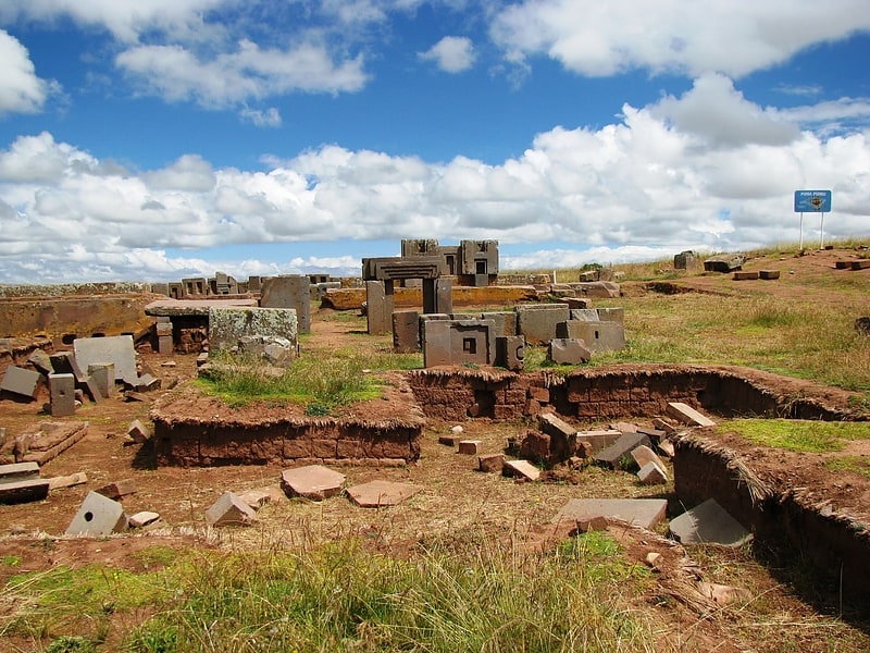
Pumapunku, Tiwanaku
Also known as: Puma Punku
Archeologically significant stone blocks. Pumapunku or Puma Punku is a 6th-century T-shaped and strategically aligned man-made terraced platform mound with a sunken court and monumental structure on top that is part of the Pumapunku complex, at the Tiwanaku Site near Tiwanacu, in western Bolivia. The Pumapunku complex is an alignment of plazas and ramps centered on the Pumapunku platform mound. Today the monumental complex on top of the platform mound lies in ruins.
It is believed to date to AD 536. After Akapana, which is believed to be "Pumapunku's twin", Pumapunku was the second most important construction in Tiwanaku. Among all the names for the areas in Tiwanaku only the names "Akapana" and "Pumapunku" have historical relevance. At Pumapunku several miniature gates which are perfect replicas of once standing full-size gateways were found. Additionally to these miniature gateways, likely, at least five gateways were once integrated into the Pumapunku monumental complex. The foundation platform of Pumapunku supported as many as eight andesite gateways. The fragments of five andesite gateways with similar characteristics to the Gateway of the Sun were found.
Tiwanaku is significant in Inca traditions because it is believed to be the site where the world was created. In Aymara, Puma Punku's name means "Gate of the Puma". The Pumapunku complex consists of an unwalled western court, a central unwalled esplanade, a terraced platform mound that is faced with stone, and a walled eastern court.
At its peak, Pumapunku is thought to have been "unimaginably wondrous," adorned with polished metal plaques, brightly colored ceramic and fabric ornamentation, and visited by costumed citizens, elaborately dressed priests, and elites decked in exotic jewelry. Current understanding of this complex is limited due to its age, the lack of a written record, and the current deteriorated state of the structures due to treasure hunting, looting, stone mining for building stone and railroad ballast, and natural weathering.[5]
Cerro Rico, Potosí
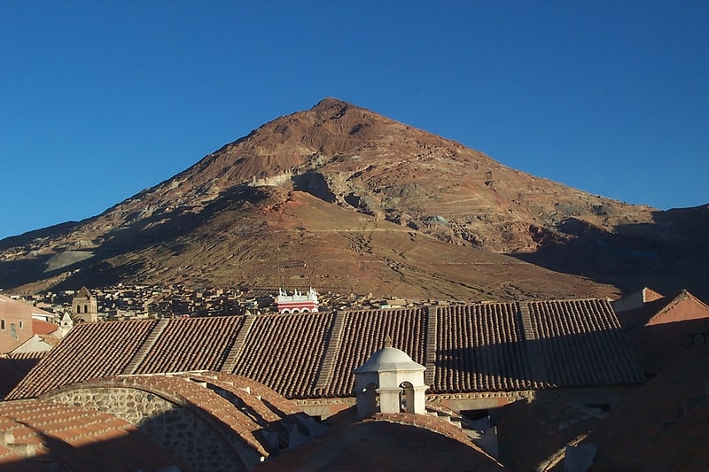
Mountain in Bolivia. Cerro Rico, Cerro Potosí or Sumaq Urqu, is a mountain in the Andes near the Bolivian city of Potosí. Cerro Rico, which is popularly conceived of as being "made of" silver ore, is famous for providing vast quantities of silver for the Spanish Empire, most of which was shipped to metropolitan Spain. It is estimated that eighty-five percent of the silver produced in the central Andes during this time came from Cerro Rico. As a result of mining operations in the mountain, the city of Potosí became one of the largest cities in the New World.[6]
Address: Aycucho # 19, Potosí
Kalasasaya, Tiwanaku
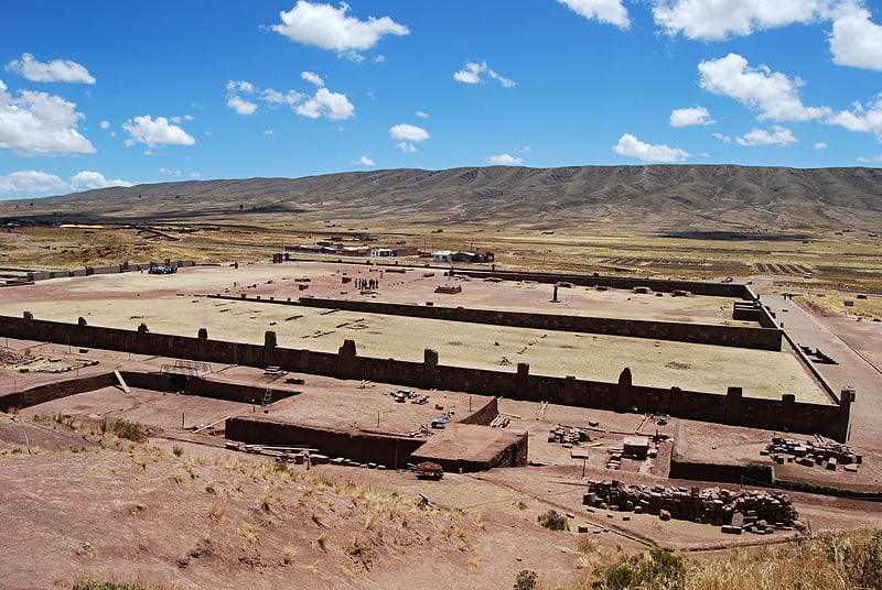
Archaeological site in Tiwanaku, La Paz, Bolivia. The Kalasasaya or Stopped Stones is a major archaeological structure that is part of Tiwanaku, an ancient archeological complex in the Andes of western Bolivia that is designated as a UNESCO World Heritage Site.
The Kalasasaya is a low platform mound with a large courtyard, which is surrounded by high stone walls. The Kalasasaya is about 120 by 130 meters in dimension and aligned to the cardinal directions. Like the other platform mounds within Tiwanaku, it has a central sunken court. This sunken court can be reached by a monumental staircase through an opening in its eastern wall. The walls are composed of sandstone pillars that alternated with sections of smaller blocks of Ashlar masonry. This wall has been reconstructed in modern times. From 1957-1960 excavations took place at the site where all 4 walls were reconstructed along with the entrance gate.
The Kalasasaya dates to at least 200 BCE - 200 CE. It is located to the north of the Akapana and west of the Semi-Subterranean Temple, other structures in the complex.[7]
Gate of the Sun, Tiwanaku
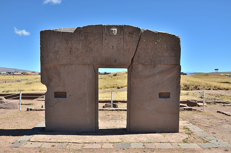
Also known as: Puerta del Sol
Archaeological site in Tiwanaku, La Paz, Bolivia. The Gate of the Sun, also known as the Gateway of the Sun, is a monolith carved in the form of an arch or gateway at the site of Tiahuanaco by the Tiwanaku culture, an Andean civilization of Bolivia that thrived around Lake Titicaca in the Andes of western South America around 500-950 CE.
Tiwanaku is located near Lake Titicaca at about 12,549.2 ft (3,825.0 m) above sea level near La Paz, Bolivia. The Gate of the Sun is approximately 9.8 ft (3.0 m) tall and 13 ft (4.0 m) wide, and was carved from a single piece of stone. Its weight is estimated to be 10 tons. When rediscovered by European explorers in the mid-19th century, the megalith was lying horizontally and had a large crack through it. It presently stands in the location where it was found, although it is believed that this is not its original site, which remains uncertain.
Some elements of Tiwanaku iconography spread throughout Peru and parts of Bolivia. Although there have been various modern interpretations of the mysterious inscriptions found on the object, the carvings that decorate the gate are believed to possess astronomical and/or astrological significance and may have served a calendrical purpose. In addition, scholars have found that the design below the central figure is meant to represent celestial cycles. Being a later monument to the site in which it stands, the Gateway of the Sun could have also represented a transition from lunar religion to a solar religion based on its positioning to the sun to the West.[8]
Parque Cretácico, Sucre
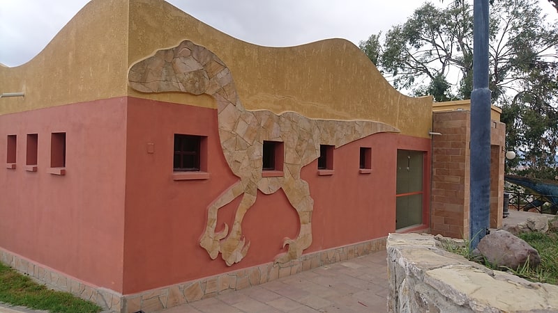
Amusement, View point, Science museum, Amusement park
Address: Avenida Francisco Mendoza Ferrer, Sucre
Cathedral Basilica of St. Lawrence, Santa Cruz
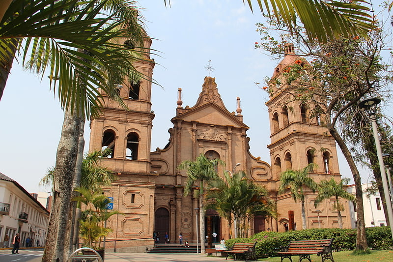
Also known as: Catedral basílica de San Lorenzo
Basilica in Santa Cruz de la Sierra, Bolivia. The Cathedral Basilica of St. Lawrence, also called Santa Cruz de la Sierra Cathedral, is the main Catholic church in the city of Santa Cruz de la Sierra, Bolivia. It is located in the city center, opposite the 24 de Septiembre Square.
The first church was built by the Mercedarian Fray Diego de Porres in times of Viceroy Francisco Álvarez de Toledo. In 1770, Bishop Ramán de Herbosos rebuilt the church, commending the sacristan Antonio Lombardo greatest gift the execution of the works. At the time of Marshal Andrés de Santa Cruz (1838), the old temple was replaced by a new church of eclectic style, designed by the French architect Felipe Bertres. It is notable for its wooden vaults and the pictorial decoration that covers them. In the main altar part of the original carved silver coating of the Jesuit mission of San Pedro de Moxos it is conserved. Four sculptural reliefs from the same mission are also exhibited.[9]
Address: Plaza 24 de Septiembre, Santa Cruz
Metropolitan Cathedral of Sucre, Sucre
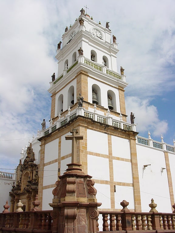
Also known as: Catedral basílica de Nuestra Señora de Guadalupe
Expansive cathedral and 16th-century art. The Metropolitan Cathedral of Sucre, also called Cathedral Basilica of Our Lady of Guadalupe is a cathedral of Sucre, formerly La Plata, Bolivia is the seat of the Roman Catholic Church in Bolivia. It was built between 1559 and 1712.[10]
Address: Plaza 25 de Mayo, Sucre
Cal Orck'o, Sucre
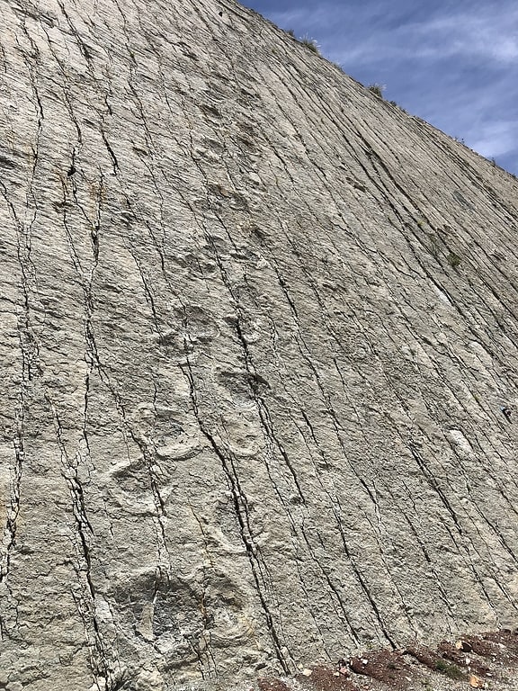
Also known as: Cal Orcko
Archaeological site in Sucre, Bolivia. Cal Orck’o is a fossil bed in Bolivia. It is located in a quarry approximately 4.4 km northwest of Sucre in the Altiplano/Cordillera Oriental, in the El Molino Formation.
The bed is composed of oolitic fossiliferous limestone, associated with large, freshwater stromatolites and nine levels of dinosaur tracks (trace fossils) in the El Molino Formation document an open lacustrine environment.
The main track-bearing level is almost vertical with a surface area of ~ 65,000 m2. The high-resolution mapping of the site from 1998 to 2015 revealed a total of 12,092 individual dinosaur tracks in 465 trackways. Nine different morphotypes of dinosaur tracks have been documented. Amongst them are several trackways of theropods, ornithopods, ankylosaurs and sauropods, with the latter group accounting for 26% of the trackways.[11]
Museo del Convento de Santa Teresa, Potosí
Sacred and religious sites, Museum, Historical place
Address: Calle Santa Teresa 15, Potosí
Cristo de la Concordia, Cochabamba
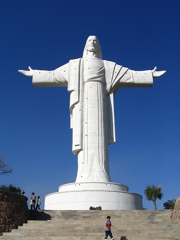
Hilltop statue of Jesus Christ. Cristo de la Concordia is a statue of Jesus Christ located atop San Pedro Hill, to the east of Cochabamba, Bolivia. It is accessible by cable car, or by climbing 2,000 steps. The statue is 34.20 metres tall, on a pedestal of 6.24 metres, for a total height of 40.44 metres.[12]
Metropolitan Cathedral of Saint Sebastian, Cochabamba
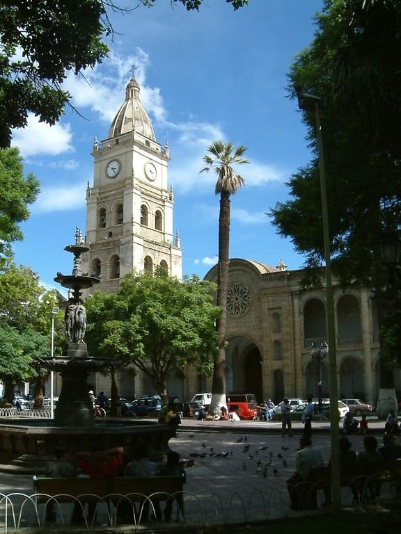
Also known as: Catedral de San Sebastián
Cathedral in Cochabamba, Bolivia. The Metropolitan Cathedral of Saint Sebastian is the cathedral of the Roman Catholic Church in the Archdiocese of Cochabamba. It is located in the Plaza 14 de Septiembre in Cochabamba, Bolivia.[13]
Address: Calle Plaza 14 de Septiembre, Cochabamba
Templo y Convento Santa Teresa, Cochabamba
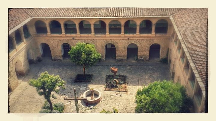
Museum, Historical place, History museum, Church
Address: Calle Babtista entre Ecuador y Mayor Rocha, Cochabamba
Zoologico, Santa Cruz
The Municipal Zoo of South American Fauna Noel Kempff Mercado, is located in the city of Santa Cruz de la Sierra, Bolivia. It is the most important in the country and in South America, for the extensive biodiversity of native species, it is also one of the main tourist attractions of the city.
Its founder was Prof. Noel Kempff Mercado, who in the early 1960s, had already made a career as a naturalist and creator of the Botanical Garden Hortus Amazonicus Tropicalis Boliviensis, located on the banks of the Piraí River (Bolivia). As a result, he conceived the idea of building a zoo dedicated exclusively to South American fauna. It should also be remembered that, simultaneously and as Municipal Director of Parks and Gardens, it was he who initiated the process of urban tree planting that has given the city an unmistakable appearance.
At the entrance of the zoo, you can see a statue of the naturalist mentioned above, in which his figure holds with his hands several animals, this sculpture was made in tribute to the great work he carried out for the conservation of the fauna and flora of South America.
Lomas de Arena Regional Park, Santa Cruz
Lomas de Arena Regional Park is a protected area in Bolivia, located 12 km southeast of the city of Santa Cruz de la Sierra. It is one of the most visited tourist attractions in the region, and has an area of 14,075.9 ha divided between the municipal territories of La Guardia, Santa Cruz de la Sierra and Cabezas. It is famous for having dunes up to 12 meters high, with landscapes that include savannah, forest and a main lagoon. It can be reached from the city of Santa Cruz by car through a road with stretches of asphalt, dirt and sand.
Ch'iyar Qirini, Chacaltaya
Mountain in Bolivia. Ch'iyar Qirini is a 5,363-metre-high mountain in the Cordillera Real in the Bolivian Andes, north-east of La Paz. It lies in the La Paz Department, Murillo Province, La Paz Municipality, near the border with the El Alto Municipality. Ch'iyar Qirini is situated north-east of the mountain Chacaltaya and north of the two Qillwani Lakes.[14]
Laram Quta, Chacaltaya
Lake. Laram Quta is a lake in Bolivia located in the La Paz Department, Pedro Domingo Murillo Province, El Alto Municipality. It lies south of the mountain Chacaltaya, south-east of Milluni Lake, south-west of the Qillwani Lakes and north-west of Qillwani. Laram Quta is situated at a height of about 4,556 metres, about 0,5 km long and 0,17 km at its widest point.[15]
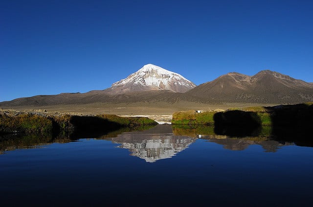
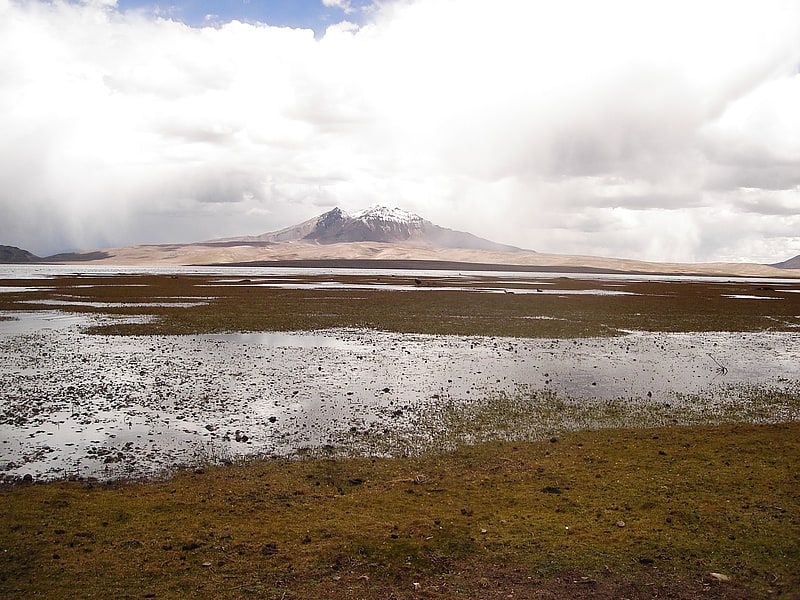
Nevado Sajama, Sajama National Park
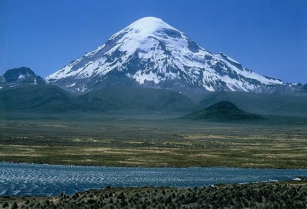
Volcano in Bolivia. Nevado Sajama is an extinct stratovolcano and the highest peak in Bolivia. The mountain is located in the Oruro Department, Sajama Canton. It is situated in Sajama National Park and is a composite volcano consisting of a stratovolcano on top of several lava domes. It is not clear when it erupted last but it may have been during the Pleistocene or Holocene.
The mountain is covered by an ice cap and Polylepis tarapacana trees occur up to 5,000 metres (16,000 ft) elevation.[16]
Milluni Lake, Chacaltaya
Lake in Bolivia. Milluni is a lake on the western side of the Cordillera Real of Bolivia located in the La Paz Department, Pedro Domingo Murillo Province, El Alto Municipality, north of El Alto.
The lake is situated at a height of 4,565 metres (14,977 ft) south of the mountain Wayna Potosí, at the foot of Chacaltaya. It is about 1.83 km long and 1 km at its widest point. The surface is 2.37 km² (0.92 sq mi). At the south side there is a dam.
Milluni Lake is also called Milluni Grande (Spanish for big) in order to distinguish it from a smaller, half moon shaped lake next to it in the north, Milluni Chico (Spanish for small), which is situated at a height of 4,585 m.[17]
Wisalla, Sajama National Park
Mountain in Bolivia. Wisalla is a 5,031-metre-high mountain in the Andes of Bolivia. It is situated in the Oruro Department, Sajama Province, Curahuara de Carangas Municipality. Wisalla lies south-west of the dormant Sajama volcano.[18]
K'isi K'isini, Sajama National Park
Mountain in Chile. K'isi K'isini is a 5,536-metre-high mountain in the Cordillera Occidental in the Andes of Bolivia. It is located in the Oruro Department, Sajama Province, Curahuara de Carangas Municipality, Sajama Canton. K'isi K'isini is situated inside the boundaries of the Sajama National Park, south-east of the Parina Quta and Pomerape volcanoes and north of the Bolivian route 4 that leads to the Chungara–Tambo Quemado mountain pass on the border with Chile.[19]
Inka Raqay, Tunari National Park
Inka Raqay is an archaeological site in Bolivia. It is located in the Cochabamba Department, Quillacollo Province, Sipe Sipe Municipality, near the community of Linku.
Inka Raqay was declared a National Archaeological Monument by Law No. 3479 of September 22, 2006. By Law No. 295 of September 28, 2012, it was declared a Historical and Cultural Heritage of the Bolivian state. It is one of the historical places where Willkakuti, the Andean-Amazonic New Year, is celebrated.[20]