Discover 11 hidden attractions, cool sights, and unusual things to do in Gran Canaria (Spain). Don't miss out on these must-see attractions: Roque Bentayga, Cenobio de Valerón, and Bandama Caldera. Also, be sure to include Four Doors cave site in your itinerary.
Below, you can find the list of the most amazing places you should visit in Gran Canaria (Canary Islands).
Table of Contents
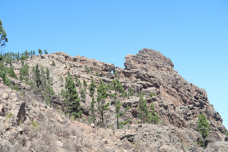
Roque Bentayga
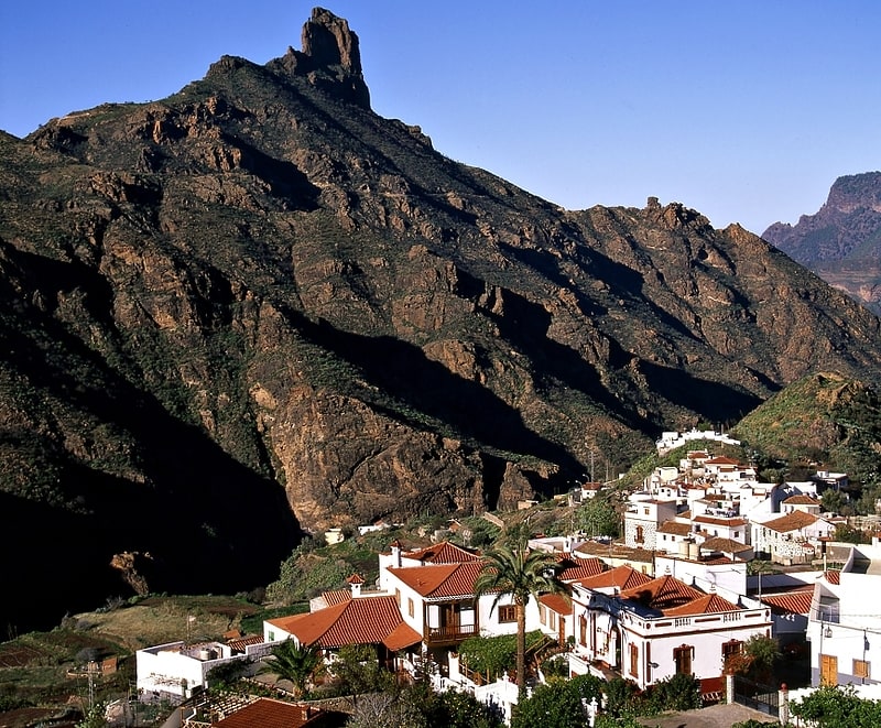
Roque Bentayga is a rock formation on the island of Gran Canaria. It is located within the volcanic caldera of Tejeda, in the municipality of the same name, in the heart of the island. Roque Bentayga is considered an archaeological monument because it contains an "almogarén".[1]
Cenobio de Valerón
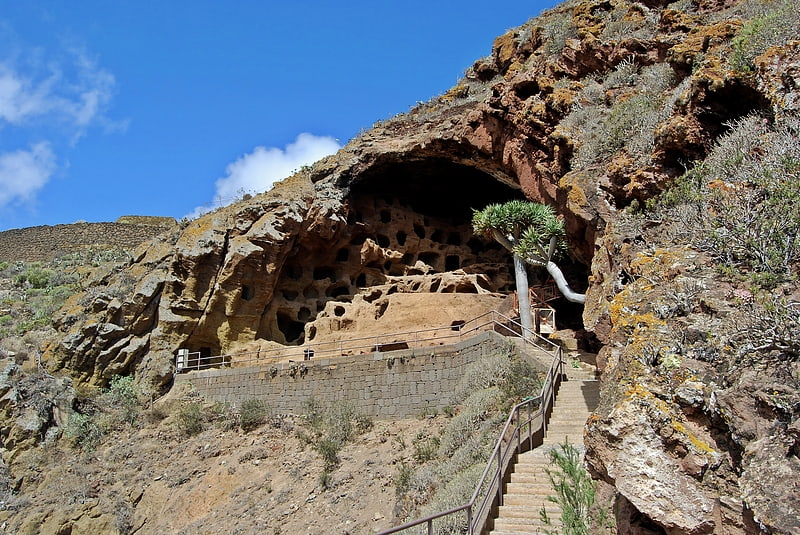
Tourist attraction in Spain. Valerón's "monastery" is an archaeological site on the Spanish island of Grand Canary, in the municipality of Santa Maria de Guia, on Valerón's cliff. It is the largest pre-Hispanic collective granary built before Roman times and used by the island's inhabitants until the conquest of the island at the end of the 15th century.
Close to Gáldar Painted cave, it is one of the emblematic sites of Grand Canary and is listed as a Spanish Property of cultural interest.[2]
Address: Cuesta de Silva S/N, Gran Canaria
Bandama Caldera
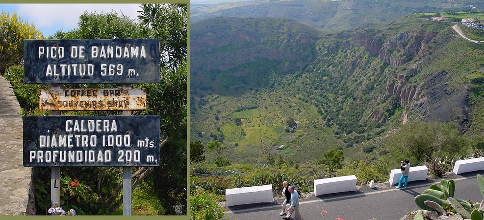
Also known as: Caldera de Bandama
Huge volcanic crater with hiking trails. The Bandama Natural Monument is part of the Tafira Protected Landscape on the island of Gran Canaria in the Canary Islands, Spain. It's considered a point of geological interest, because of the Caldera de Bandama. This volcanic crater, which is geologically a maar rather than a caldera, reaches 569 m above sea level at the highest point on its rim, Pico de Bandama, and is about 1,000 m wide and 200 m deep. The crater was developed during the last heavy eruptions 2000 years ago. It is recorded as the last volcanic activity on Gran Canaria.
The bottom of the caldera contains volcanic ash of different colors, and some botanic species of Canary Islands origin. An endemic bush can be found inside the caldera that doesn’t grow anywhere else; Dama de Bandama (parolinia grabiuscula).
The Caldera de Bandama is located at the meeting point of three municipalities: Las Palmas de Gran Canaria, Santa Brígida and Telde.[3]
Four Doors cave site
Also known as: Cuatro Puertas
Open air museum in Spain. The Four Doors site, also known as Montaña Bermeja, 'Vermillion Mountain', is a complex of caves in the south of the municipality of Telde, Gran Canaria.
The Cuatro Puertas site is named after its most spectacular cave, the most emblematic of Gran Canaria due to its uniqueness and location. The site includes many other caves, some linked with each other. A small village nearby also bears that name, as well as a ravine (barranco de Cuatro Puertas).
The site is listed as Spanish Heritage as a Property of cultural interest.[4]
Morro de la Agujereada
Morro de la Agujereada is the highest altitude of the island of Gran Canaria, Canary Islands, Spain. Located in Pico de las Nieves, it reaches a height of 1,956 meters above sea level, being the highest altitude in the province of Las Palmas. Gran Canaria is the third highest island in the Canary Islands, after Tenerife and La Palma.
Although traditionally Pico de las Nieves was considered to be 1,949 meters high, Morro de la Agujereada actually reaches its highest point at 1,956 meters. Morro de la Agujereada is a rocky promontory at the highest point of Pico de las Nieves, whose slopes cover the central area of the summit, and in which numerous snow pits were dug in the past.[5]
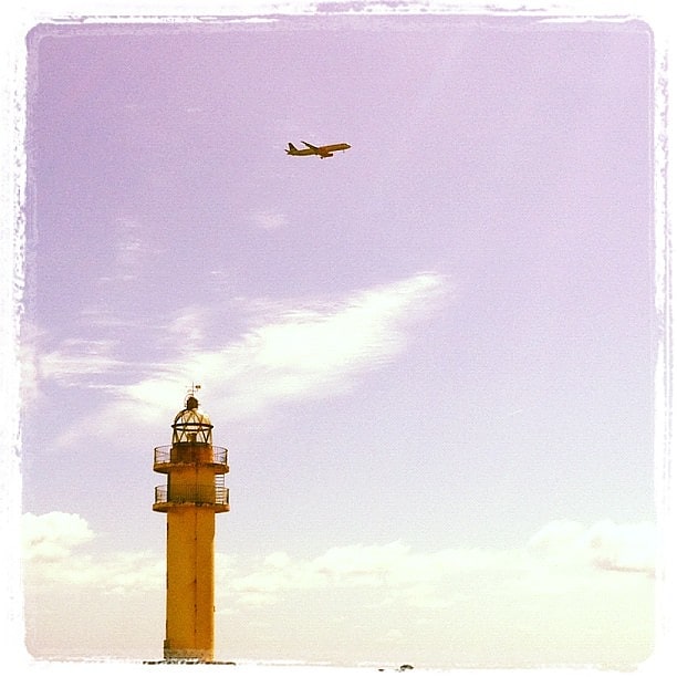
Punta Sardina Lighthouse
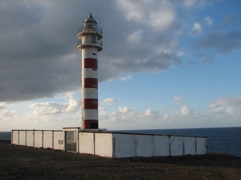
Also known as: Faro de Punta Sardina
Lighthouse. The Punta Sardina Lighthouse is an active lighthouse on the Canary island of Gran Canaria. It is located north of the small town of Sardina, in the municipality of Gáldar. The Punta Sardina light marks the north-western extremity of the island, and lies between the Punta del Castillete lighthouse near Puerto de Mogán to the south and the La Isleta lighthouse of Las Palmas to the east.[6]
Punta de Arinaga Lighthouse
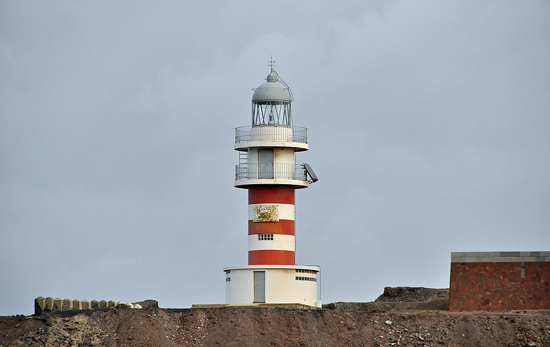
Also known as: Faro de Punta de Arinaga
Lighthouse in Spain. The Punta de Arinaga Lighthouse is an active lighthouse on the Spanish island of Gran Canaria in the Canary islands. The current lighthouse tower is the third to be constructed on the rocky headland of Punta Arinaga, near the town of the same name in the municipality of Agüimes. Arinaga is on the south-east side of the island and marks the coastline between the Maspalomas lighthouse to the south and the Punta de Melenara lighthouse of Telde to the north.[7]
Address: Paseo del Faro, S/N, 35118 Gran Canaria
Punta del Castillete Lighthouse
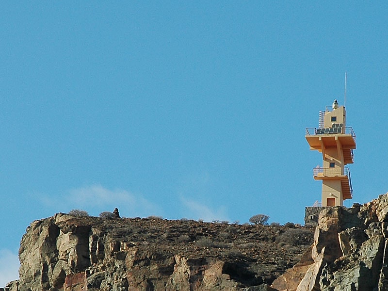
Also known as: Faro de Punta del Castillete
Tourist attraction in Spain. The Punta del Castillete Lighthouse is an active lighthouse on the Canary island of Gran Canaria. It is located on cliffs above the resort and fishing harbour of Puerto de Mogán, in the municipality of Mogán. Punta Castillete is on the south-western side of the island facing the Atlantic Ocean, and lies between Maspalomas Lighthouse to the south and the lighthouse of Punta Sardina to the north.[8]
Punta de Melenara Lighthouse
Also known as: Faro de la Punta de Melenara
The Punta de Melenara Lighthouse also known as the Faro de Taliarte is an active 20th century lighthouse on the Spanish island of Gran Canaria in the Canary islands.
The lighthouse has been constructed on Melenara Point, a rocky headland between the beaches of Playa del Hombre and Playa de Melenara, which lies next to the settlement of Taliarte and its port, in the municipality of Telde. Located on the eastern side of the island, the Punta de Melenara light marks the coastline between the La Isleta lighthouse of Las Palmas to the north and the Punta de Arinaga lighthouse to the south.[9]
Pozo Izquierdo
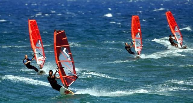
Beach
Address: C/ La Chopa, 1 - Pozo Izquierdo, Gran Canaria
Port of Arinaga
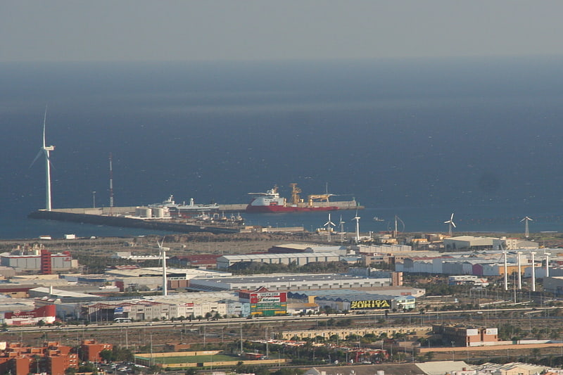
The port of Arinaga is a small seaport off the eastern coast of the Spanish island of Gran Canaria, in the Canary Islands, themselves located in the Mid-Atlantic.
It was not until the later part of the 19th century when the construction of a small harbor in order to facilitate the agricultural exports of the southern part of the island was proposed. Works initiated following the 1917 crisis during World War I and, in 1927, an expansion was commissioned, although it would not take place at the time. Later in the 20th century a mammoth project that would make the port bigger than Las Palmas' was ultimately shelved in the 1970s.
An offshore wind turbine was installed in the harbor, and, in 2013, it broke the national record in Spain for electric production in a single generator, reaching 118,05 MWh.
It is operated by the Port Authority of Las Palmas. As of 2020, its activity focuses on the handling of solid bulk.[10]