Discover 11 hidden attractions, cool sights, and unusual things to do in Crater Lake National Park (United States). Don't miss out on these must-see attractions: Crater Lake, Sinnott Memorial Observation Station, and Mount Scott. Also, be sure to include Watchman Lookout Station in your itinerary.
Below, you can find the list of the most amazing places you should visit in Crater Lake National Park (Oregon).
Table of Contents
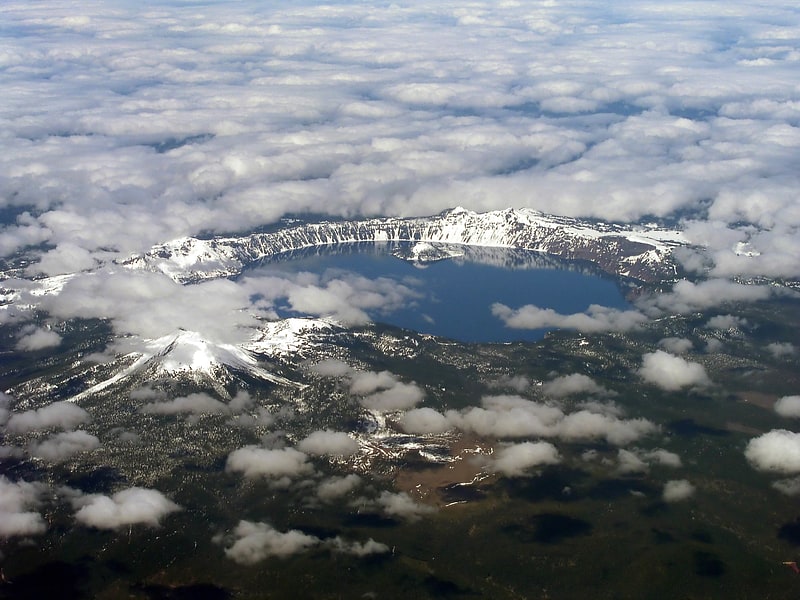
Crater Lake
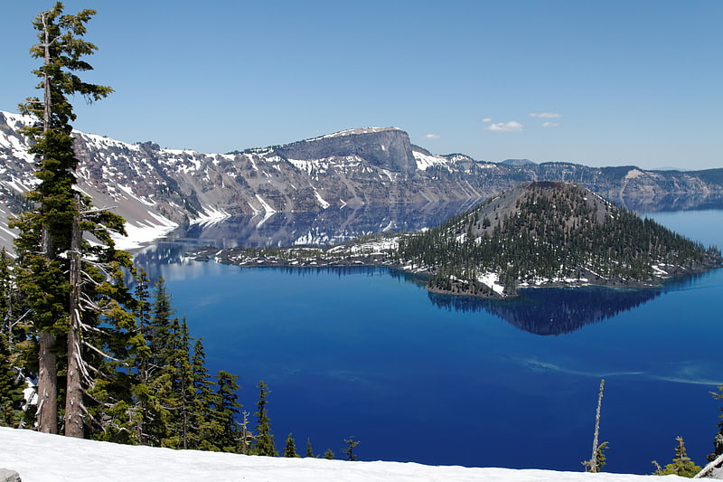
Lake in Oregon. Crater Lake is a volcanic crater lake in south-central Oregon in the western United States. It is the main feature of Crater Lake National Park and is famous for its deep blue color and water clarity. The lake partly fills a 2,148-foot-deep caldera that was formed around 7,700 years ago by the collapse of the volcano Mount Mazama. There are no rivers flowing into or out of the lake; the evaporation is compensated for by rain and snowfall at a rate such that the total amount of water is replaced every 250 years. With a depth of 1,949 feet, the lake is the deepest in the United States. In the world, it ranks ninth for maximum depth, and third for mean depth.
Crater Lake features two small islands. Wizard Island, located near the western shore of the lake, is a cinder cone approximately 316 acres (128 ha) in size. Phantom Ship, a natural rock pillar, is located near the southern shore.
Since 2002, one of Oregon's regular-issue license plate designs has featured Crater Lake and a one-time plate surcharge is used to support the operation of Crater Lake National Park. The commemorative Oregon State Quarter, which was released by the United States Mint in 2005, features an image of Crater Lake on its reverse.
The lake and surrounding park areas offer many recreational activities including hiking, biking, snowshoeing, fishing, and cross-country skiing are available, and during the summer, campgrounds and lodges at Crater Lake are open to visitors.[1]
Sinnott Memorial Observation Station
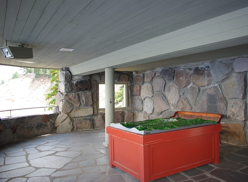
Museum in Klamath County, Oregon. The Sinnott Memorial Observation Station is a sheltered viewpoint built into the caldera cliff 900 feet above Crater Lake in southern Oregon, United States. It is located near the Rim Village Visitor Center in Crater Lake National Park. The structure includes a small natural history museum with exhibits that highlight the geologic history of Mount Mazama and the formation of Crater Lake. The building was officially dedicated as the Nicholas J. Sinnott Memorial Observation Station and Museum; however, it is commonly known as the Sinnott Memorial Overlook or Sinnott Viewing Area. It is architecturally significant because it was the first National Park Service building constructed specifically as a museum and the first structure built in Crater Lake National Park using rustic stone masonry construction. It is listed on the National Register of Historic Places as Sinnott Memorial Building No. 67.[2]
Mount Scott
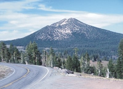
Highest point in Crater Lake Park. Mount Scott is a small stratovolcano and a so-called parasitic cone on the southeast flank of Crater Lake in southern Oregon. It is approximately 420,000 years old. Its summit is the highest point within Crater Lake National Park, and the tenth highest peak in the Oregon Cascades. A small fire lookout tower stands on the summit, at the end of a trail that zigzags approximately 1,500 feet up the mountain. The mountain is named for Oregon pioneer Levi Scott, founder of Scottsburg, Oregon.[3]
Watchman Lookout Station
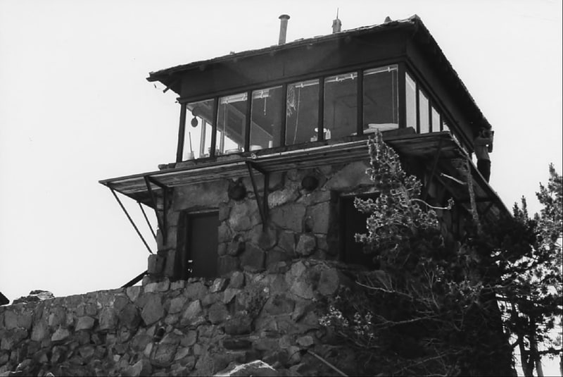
Building. The Watchman Lookout Station No. 168 is one of two fire lookout towers in Crater Lake National Park in southern Oregon. For many years, National Park Service personnel used the lookout to watch for wildfires during the summer months. It is also a common hiking destination because of its views of Crater Lake and the surrounding area. The building is unusual because it serves the dual purpose of fire lookout and museum. The Watchman Lookout Station is listed on the National Register of Historic Places.[4]
Mount Mazama
Collapsed volcano with Crater Lake. Mount Mazama is a complex volcano in the state of Oregon, United States, in a segment of the Cascade Volcanic Arc and Cascade Range. Most of the mountain collapsed following a major eruption approximately 7,700 years ago. The volcano is in Klamath County, in the southern Cascades, 60 miles north of the Oregon–California border. Its collapse formed a caldera that holds Crater Lake. The mountain is in Crater Lake National Park. Mount Mazama originally had an elevation of 12,000 feet, but following its climactic eruption this was reduced to 8,157 feet. Crater Lake is 1,943 feet deep, the deepest freshwater body in the US and the second deepest in North America after Great Slave Lake in Canada.
Mount Mazama formed as a group of overlapping volcanic edifices such as shield volcanoes and small composite cones, becoming active intermittently until its climactic eruption 7,700 years ago. This eruption, the largest known within the Cascade Volcanic Arc in a million years, destroyed Mazama's summit, reducing its approximate 12,000-foot (3,700 m) height by about 1 mile (1,600 m). Much of the edifice fell into the volcano's partially emptied neck and magma chamber, creating a caldera. The region's volcanic activity results from the subduction of the offshore oceanic plate, and is influenced by local extensional faulting. Mazama is dormant, but the US Geological Survey says eruptions on a smaller scale are likely, which would pose a threat to its surroundings.
Native Americans have inhabited the area around Mazama and Crater Lake for at least 10,000 years and the volcano plays an important role in local folklore. European-American settlers first reached the region in the mid-19th century. Since the late 19th century, the area has been extensively studied by scientists for its geological phenomena and more recently for its potential sources of geothermal energy. Crater Lake and Mazama's remnants sustain diverse ecosystems, which are closely monitored by the National Park Service because of their remoteness and ecological importance. Recreational activities including hiking, biking, snowshoeing, fishing, and cross-country skiing are available, and during the summer, campgrounds and lodges at Crater Lake are open to visitors.[5]
Garfield Peak
Mountain in Oregon. Garfield Peak is a mountain peak on the south end of Crater Lake in Crater Lake National Park, Oregon. The top of the peak reaches 7,976 feet above sea level. The peak has a 1,000 feet elevation trail to the summit from the Crater Lake lodge, one of the most popular hiking sites surrounding the lake. The 1.7-mile trail continues east toward Applegate peak. The peak is one of seven peaks on Crater Lake's rim to rise above 8,000 feet.[6]
Union Peak
Shield volcano in Oregon. Union Peak is a heavily eroded shield volcano in the Cascade Range of central Oregon, located along the Cascade Crest less than 7 miles southwest of the rim of Crater Lake. Ice age glaciers eroded away most of the flanks of the volcano, leaving numerous deep cirques surrounding a central glacial horn. This is the same process that formed the summit horns of Three Fingered Jack, Mount Washington, Howlock Mountain, and Mount Thielsen from other shield volcanoes farther north in the Oregon Cascades.
Union Peak is located within Crater Lake National Park, and the summit was used as a post for fire lookouts from the 1930s to the 1950s. A 5.5-mile (8.9 km) trail leads to the summit from the Pacific Crest Trail off Oregon Route 62.[7]
Annie Falls
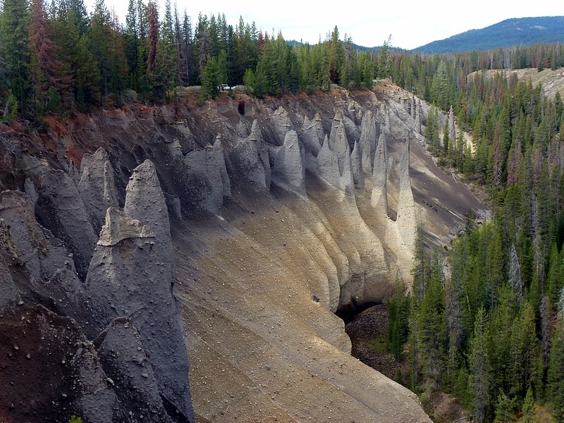
Waterfall in Oregon. Annie Falls, is the tallest of three waterfalls so named, located along Annie Creek in the Crater Lake National Park at the south end of Rim Village Historic District, in Klamath County, in the U.S. state of Oregon. It is located in a steep canyon area surrounded by walls of petrified volcanic ash as a consequence of the Mount Mazama eruption. The location of Annie Creek Falls deep in the Annie Creek canyon makes it very difficult to reach the waterfall. Partial views of the cascade can be seen from a picnic area off the Volcanic Legacy Scenic Byway south of Crater Peak. Access to Annie Creek is available at the USFS snow park, both the creek and the waterfall possess a high water flow.[8]
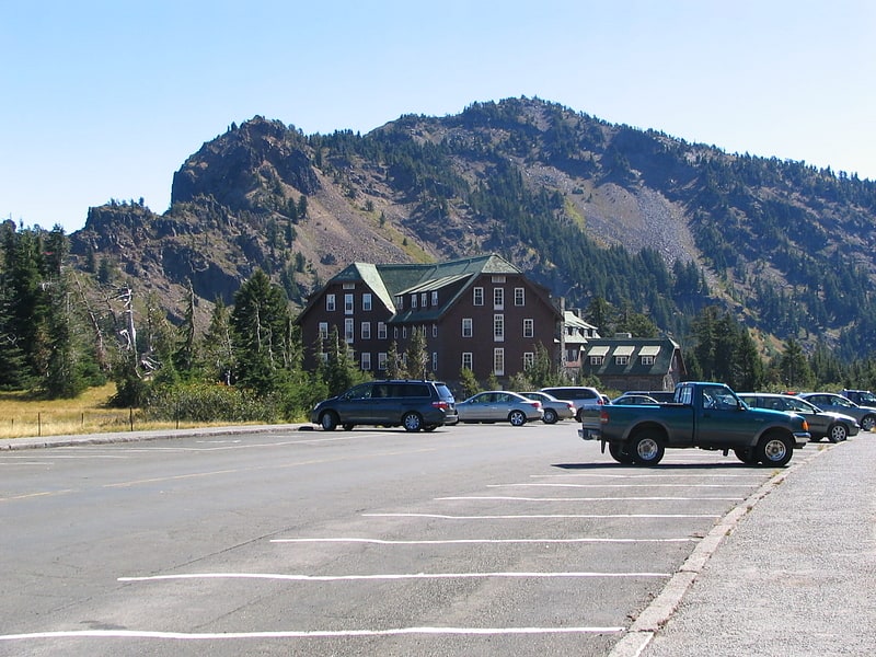
Rim Village Historic District
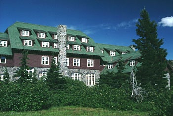
Rim Village is the main area for tourist services in Crater Lake National Park in southern Oregon, United States. It is located on the southwest rim of the caldera overlooking Crater Lake. The National Park Service designed Rim Village to concentrate park services at a location that provided easy access to rim trails and view points. Because of the unique rustic architecture of the Rim Village structures and the surrounding park landscape, the area was listed as Rim Village Historic District on the National Register of Historic Places in 1997.[9]
Old Man of the Lake
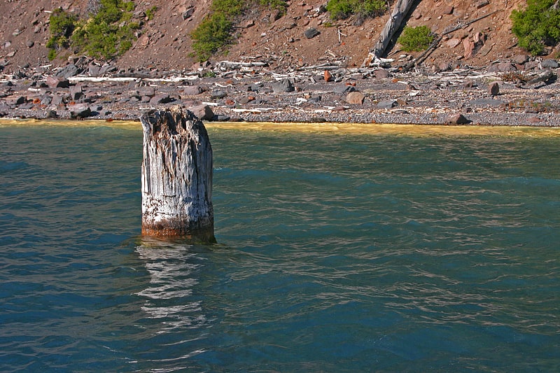
The Old Man of the Lake is a 30-foot tall tree stump, most likely a hemlock, that has been bobbing vertically in Oregon's Crater Lake since at least 1896.
The stump is about 2 feet (61 cm) in diameter at the waterline and stands approximately 4 feet (1.2 m) above the water. Its surface has been bleached white due to photodegradation. The exposed end of the floating tree is splintered and worn but wide and buoyant enough to support a person's weight.
Fontinalis, a moss present in the waters of Crater Lake at a depth of 394 feet (120 m), also grows on the Old Man of the Lake, the only place the moss is found near the surface.[10]
Comfort Station No. 68
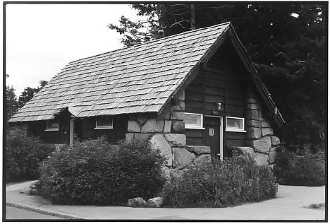
Building in Klamath County, Oregon. Comfort Station No. 68 is a historic visitor services building in Crater Lake National Park in southern Oregon, United States. It was built in 1938 to provide a public toilet and shower facilities for park visitors. It was constructed in the National Park Service Rustic style of architecture, and was listed on the National Register of Historic Places in 1988.[11]