Discover 11 hidden attractions, cool sights, and unusual things to do in Thunder Ridge Wilderness (United States). Don't miss out on these must-see attractions: Linville Falls, Crabtree Falls, and Mabry Mill. Also, be sure to include Flat Top Manor in your itinerary.
Below, you can find the list of the most amazing places you should visit in Thunder Ridge Wilderness (Virginia).
Table of Contents
Linville Falls
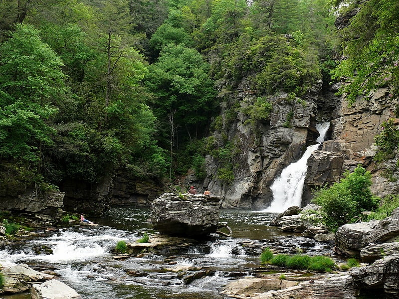
Waterfall in North Carolina. Linville Falls is a waterfall located in the Blue Ridge Mountains of North Carolina in the United States. The falls move in several distinct steps, beginning in a twin set of upper falls, moving down a small gorge, and culminating in a high-volume 45-foot drop. It is named for the Linville River, which goes over the falls. Linville Falls has the highest volume of any waterfall on the Northern Edge of the Blue Ridge Mountains.[1]
Crabtree Falls
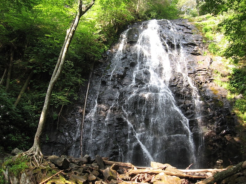
Waterfall in North Carolina. Crabtree Falls is a waterfall located near the boundary of McDowell County and Yancey County, North Carolina.[2]
Address: Blue Ridge Pkwy, 27603 Burnsville
Mabry Mill
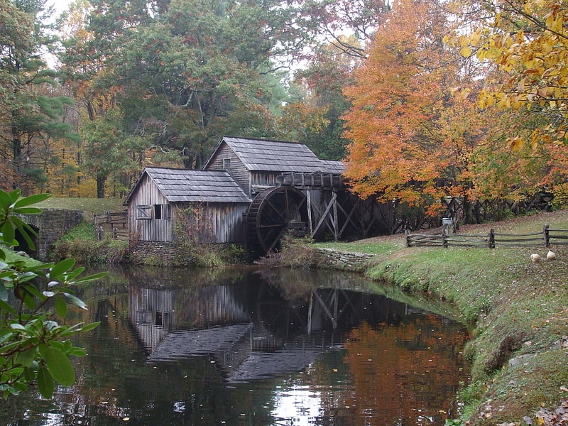
Mabry Mill is a watermill run by the National Park Service located at milepost 176.2 of Blue Ridge Parkway in Floyd County, Virginia. It is a tourist attraction mainly for the picturesque views of the mill itself. A short trail around the mill connects historical exhibits about life in rural Virginia. The trail allows visitors to view the gristmill, sawmill, and blacksmith shop.
Mabry Mill was built by Edwin Boston Mabry (E.B. Mabry). E.B. Mabry returned to Floyd County in 1903 and began the construction of the mill. It was first a blacksmith and wheelwright shop, then became a sawmill. By 1905 it was in operation as a gristmill. By 1910 the front part of the mill was completed and included a lathe for turning out wheel hubs, a tongue and groove lathe, a planer and a jig-saw. Between 1905 and 1914 E.B. Mabry bought adjacent tracts of land, mostly for the purpose of acquiring more water power.
During peak seasons, demonstrations of crafts are given by National Park Service volunteers at Mabry Mill.[3]
Address: 266 Mabry Mill Rd SE, Meadows of Dan, VA 24120, Thunder Ridge Wilderness
Flat Top Manor
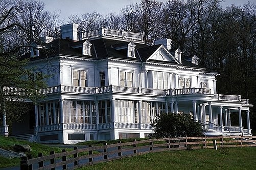
Historical place in Watauga County, North Carolina. Flat Top Manor, as it is most commonly known, is also called the Moses Cone Manor, Moses Cone Estate, and the Moses H. Cone Mansion. It is at Milepost 294 of the Blue Ridge Parkway in Blowing Rock, North Carolina. It was built by American textile entrepreneur Moses H. Cone for his home and based on the idea of replicating George Vanderbilt's Biltmore Estate, the largest privately owned house in the United States. He used his estate to showcase his knowledge of scientific farming and to represent his wealth he had accumulated.
The manor mansion and associated property was donated to the National Park Service and they managed it. The house is referred to as the Parkway Craft Center to those that travel the Blue Ridge Parkway. The Craft Center has a gift shop and a workshop where various arts and crafts are demonstrated. There are tours given by Park Rangers of the second story of the mansion and there are self-guiding trails on the property where a visitor can hike.[4]
Address: Blue Ridge Parkway MP 294, 28605 Blowing Rock
Linn Cove Viaduct
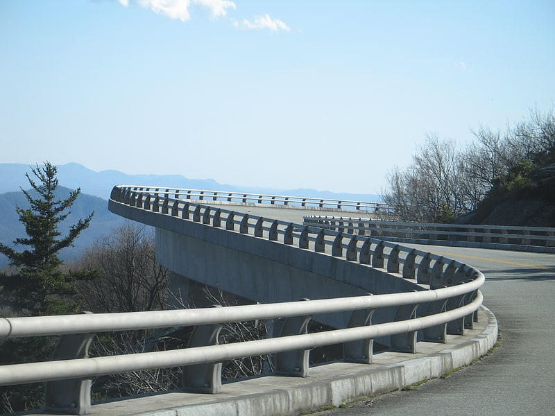
Concrete bridge in Avery County, North Carolina. The Linn Cove Viaduct is a 1,243 feet long, concrete segmental bridge which snakes around Grandfather Mountain in western North Carolina. Completed in 1983 at a cost of $10 million, it was one of the last major construction projects on the Blue Ridge Parkway which runs 469 miles linking Shenandoah National Park to Great Smoky Mountains National Park. Built mostly along the spine of the Blue Ridge, the parkway was fully completed and opened for through traffic in 1987.[5]
Blue Ridge Parkway
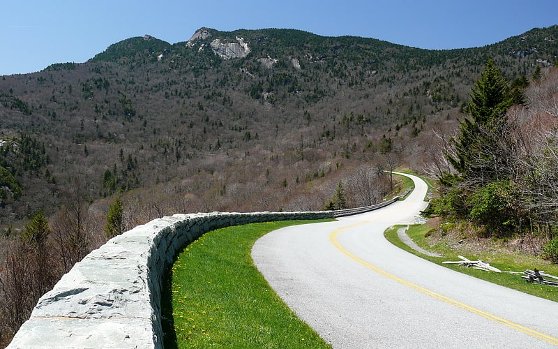
Road in the United States of America. The Blue Ridge Parkway is a National Parkway and All-American Road in the United States, noted for its scenic beauty. The parkway, which is America's longest linear park, runs for 469 miles through 29 Virginia and North Carolina counties, linking Shenandoah National Park to Great Smoky Mountains National Park. It runs mostly along the spine of the Blue Ridge, a major mountain chain that is part of the Appalachian Mountains. Its southern terminus is at U.S. Route 441 on the boundary between Great Smoky Mountains National Park and the Qualla Boundary of the Eastern Band of Cherokee Indians in North Carolina, from which it travels north to Shenandoah National Park in Virginia. The roadway continues through Shenandoah as Skyline Drive, a similar scenic road which is managed by a different National Park Service unit. Both Skyline Drive and the Virginia portion of the Blue Ridge Parkway are part of Virginia State Route 48, though this designation is not signed.
The parkway has been the most visited unit of the National Park System every year since 1946 except four (1949, 2013, 2016 and 2019). Land on either side of the road is owned and maintained by the National Park Service, and in many places parkway land is bordered by United States Forest Service property. There is no fee for using the parkway; however, commercial vehicles are prohibited without approval from the Park Service Headquarters, near Asheville, North Carolina. The roadway is not maintained in the winter, and sections that pass over especially high elevations and through tunnels are often impassable and therefore closed from late fall through early spring. Weather is extremely variable in the mountains, so conditions and closures often change rapidly. The speed limit is never higher than 45 mph (72 km/h) and is lower in some sections.
In addition to the road, the parkway has a folk art center located at mile marker 382 and a visitor center located at mile marker 384, both near Asheville. There are also numerous parking areas at trailheads for the various hiking trails that intersect the parkway, and several campgrounds located along the parkway allow for overnight stays. The Blue Ridge Music Center (also part of the park) is located in Galax, and Mount Mitchell (the highest point in eastern North America) is only accessible via North Carolina Highway 128 (NC 128), which intersects the parkway at milepost 355.4.[6]
Humpback Rock
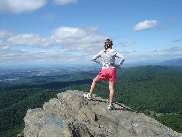
Outcrop in Virginia. Humpback Rock is a massive greenstone outcropping near the peak of Humpback Mountain in the Blue Ridge Mountains of Augusta County and Nelson County, Virginia, United States, with a summit elevation of 3,080 feet. The rock formation is so named for the visual effect of a "hump" it creates on the western face of the mountain.
Located six miles (10 km) south of the northern entrance to the Blue Ridge Parkway near Waynesboro, Virginia, Humpback Rock stands out from many other mountain summits in the Blue Ridge due to its exposed rocky summit, in contrast to the heavily vegetated peaks of surrounding mountains. The location features a well-maintained trail and visitor's center.[7]
Address: Blue Ridge Parkway, 22952 Lyndhurst
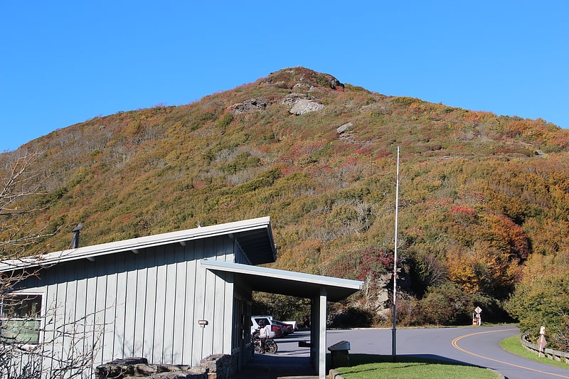
Devil's Courthouse
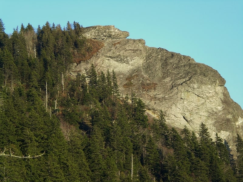
Mountain in North Carolina. Devil's Courthouse is a mountain in the Appalachian Mountains of western North Carolina in the United States of America. The mountain is located at the Western edge of the Pisgah National Forest about 10 miles northwest of Brevard and 28 miles southwest of Asheville. Located at milepost 422.4 of the Blue Ridge Parkway, the Devil's Courthouse has a moderate/strenuous trail climbing a half mile to its peak where panoramic views can be seen.[8]
Great Craggy Mountains
Mountain range in North Carolina. The Great Craggy Mountains, commonly called the Craggies, are a mountain range in western North Carolina, United States. They are a subrange of the Blue Ridge Mountains and encompass an area of approx. 194 sq mi. They are situated in Buncombe County, North Carolina, 14 miles northeast of Asheville. The Black Mountains lie to the northeast, across the upper Cane River valley.
The Blue Ridge Parkway runs along the crest for most of the way between Asheville and Mount Mitchell. Craggy Gardens, an area of 16 km, is covered with purple Catawba rhododendrons in mid-June. The Craggy Pinnacle Overlook trail is a moderate.73 mile hike to a stone wall overlook with 360 degree views. The parking area for the trail is at milepost 361.2 on the Blue Ridge Parkway.
The parkway through the area was closed from late 2012 through early 2013 due to subsidence caused by heavy rains, and had to be closed again during summer 2013 due to a reoccurrence of the same issues. Access to Mount Mitchell was only from the north or via detour from the south.[9]
Brinegar Cabin
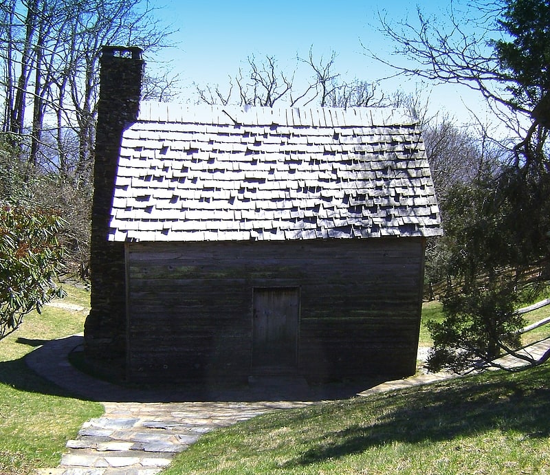
Historical landmark in Traphill, North Carolina. Brinegar Cabin is a historic home located near Whitehead, Alleghany County, North Carolina. It was built about 1880, and is a one-story log house covered with lapped siding and resting on an uncoursed fieldstone foundation. Also on the property is a contributing frame outbuilding. The property is part of the lands comprising the Blue Ridge Parkway, and the cabin houses a display of mountain crafts and weaving.
It was listed on the National Register of Historic Places in 1972.[10]
Tanasee Bald
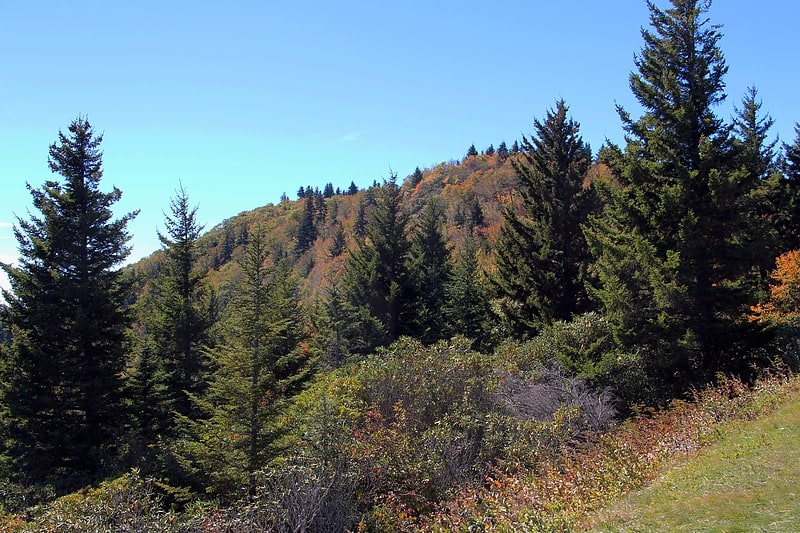
Mountain in North Carolina. Tanasee Bald, also called Tennessee Bald, is a mountain near the Blue Ridge Parkway in western North Carolina, on the Haywood/Transylvania border. It is 5561 feet high. It is in the Great Balsam Mountains within the Blue Ridge Mountains, which is part of the Appalachian Mountains
Tanasee Bald is the southern limit of breeding of the northern saw-whet owl, which is from the boreal forests of Canada.[11]